128 la representaciÓn grÁfica urbana en los …
TRANSCRIPT

128 LA REPRESENTACIÓN GRÁFICA URBANA EN LOS MANUSCRITOS DE LEONARDO DA VINCI
URBAN GRAPHIC REPRESENTATION IN LEONARDO DA VINCI’S MANUSCRIPTS
David Hidalgo García, Sergio García Doménech
doi: 10.4995/ega.2017.7345
En paralelo a la importante producción artística de Leonardo da Vinci, las novedades aportadas a las técnicas y sistemas de representación gráfica por los numerosos dibujos de sus códices, han sido tradicionalmente tratadas en un segundo plano. Dentro de este amplio universo gráfico, todavía resultan menos estudiados sus levantamientos topográficos, cartográficos y urbanos. Esta investigación analiza previamente los sistemas de representación utilizados por Leonardo en sus estudios arquitectónicos, y posteriormente expone su particular aplicación a la forma de representar los levantamientos urbanos. Si bien tanto las técnicas de perspectiva como las de proyección ortogonal ya eran comúnmente empleadas durante el Renacimiento, Leonardo mejoraría su uso mediante la combinación complementaria entre las mismas, el particular desarrollo de la perspectiva a vista de pájaro, y el empleo de diferentes gamas e intensidades cromáticas para reforzar la representación altimétrica y los diferentes elementos urbanos.
PALABRAS CLAVE: RENACIMIENTO. UR-BANISMO. CARTOGRAFíA. SISTEMAS DE REPRESENTACIÓN. LEONARDO DA VINCI
Parallel to the important Leonardo da Vinci’s artistic production, the innovations established to graphic representation systems by the numerous drawings of his manuscripts, have been treated traditionally in the background. Within this broad collection of graphics, his topographical and urban maps are even less studied. Firstly, this research, analyze graphic systems of representation used in Leonardo’s architectural studies. Then, it exposes its particular application to urban mapping. Perspective and orthogonal projection were already commonly used during the Renaissance period, but Leonardo improved its use by complementary mix between them, the particular development of bird’s eye view, and the use of colors and intensities in order to improve the quality of altimetric data and urban elements.
Keywords: renaissance. Urbanism. cartography. graphic representation systems. Leonardo da Vinci

129
expresión gráfica arquitectónica 29
Proyección ortogonal y perspectiva en la representación gráfica de Leonardo da VinciLeonardo da Vinci (1452-1519) en-carna el ideal humanista del saber universal y es considerado como una de las figuras más significativas del Renacimiento. La calidad de su producción artística resulta indiscu-tible y sus estudios e investigaciones en múltiples campos del saber desa-rrollaron ideas muy avanzadas, que han constituido referencias esenciales para posteriores avances de la ciencia moderna, en áreas tan diversas como la anatomía, la óptica o la hidráulica. También realizó aportaciones desta-cables en el campo de la representa-ción gráfica, que aplicó con profusión en el campo de la arquitectura, la car-tografía y la ingeniería.
En los manuscritos de Leonardo aparecen numerosos estudios de re-presentación gráfica arquitectónica en esquemas, anotaciones y encargos de-sarrollados dentro de su extensa pro-ducción. En estos trabajos, Leonardo empleó una combinación de perspec-tivas y proyecciones ortogonales 1. A modo de ejemplo, en el folio 24r del Manuscrito B 2, se aprecia una utili-zación combinada de la perspectiva y la proyección ortogonal (Fig. 1). La representación exterior se adapta a los criterios técnicos de la perspec-tiva caballera, método que pronto acabaría ocupando un papel relevan-te para la representación gráfica de edificios aislados. Si bien “durante el Renacimiento las representaciones téc-nicas fueron utilizadas para describir objetivamente la forma tridimensional partiendo de la síntesis visual de su configuración geométrica” (Grassa-Miranda y Giménez Morell, 2010,
p.156), también era frecuente durante este periodo emplear la doble técnica de representación que combinaba pro-yección ortogonal y perspectiva:
En los periodos iniciales y centrales del Renacimiento, los dos métodos habitua-les de representación utilizados para el espacio interior de los dibujos de arqui-tectura son: la sección perspectiva y la sección con proyección ortogonal (Lotz, 1985, p.1).
Esta circunstancia ya había sido indicada antes por James Ackerman al estudiar los dibujos de Leonardo integrados en el Códice Madrid II: “The drawings in this volume are of two kinds, two dimensional diagrams illustrating the teorical principles of the text, and isometric perspective rendering” (1977, p.48). Pero el método perspectivo utilizado por Leonardo difería considerable-mente del empleado hasta ese mo-mento por otros arquitectos y artis-tas del Renacimiento. La diferencia radicaba fundamentalmente en dos cuestiones: en primer lugar, la eleva-ción del punto de vista por encima
Orthogonal projection and perspective on graphic representation of Leonardo da VinciLeonardo da Vinci (1452-1519) was a role model for universal knowledge and is considered as one of the most significant figures of the Renaissance. The quality of his artist production is indisputable and his studies and investigations in multiple fields of knowledge developed advanced ideas, which have constituted essential references for later advances of modern science, in diverse areas such as anatomy, optics, and hydraulics. He also carried out outstanding contributions in the field of graphic representation, which were profusely applied in the field of architecture, cartography and engineering.In the manuscripts of Leonardo appear numerous studies of architectural graphic representation in schemes, annotations, and outstanding roles within his extensive production. In these works, Leonardo employed a combination of perspectives and perpendicular projections 1. For example, in the document 24r of Manuscript B 2, a combined usage of the prospective and perpendicular projection appears (Fig. 1). The external representation is adapted to the technical critiques of the cavalier projection, method that soon would come to occupy a leading role for the graphic representation of isolated buildings. Even though during the Renaissance the technical
1
1. Representación perspectiva y proyección ortogonal. Manuscrito B, folio 24r (1490)
1. Representation perspective and orthographic projection. Manuscript B, page 24r (1490)

130
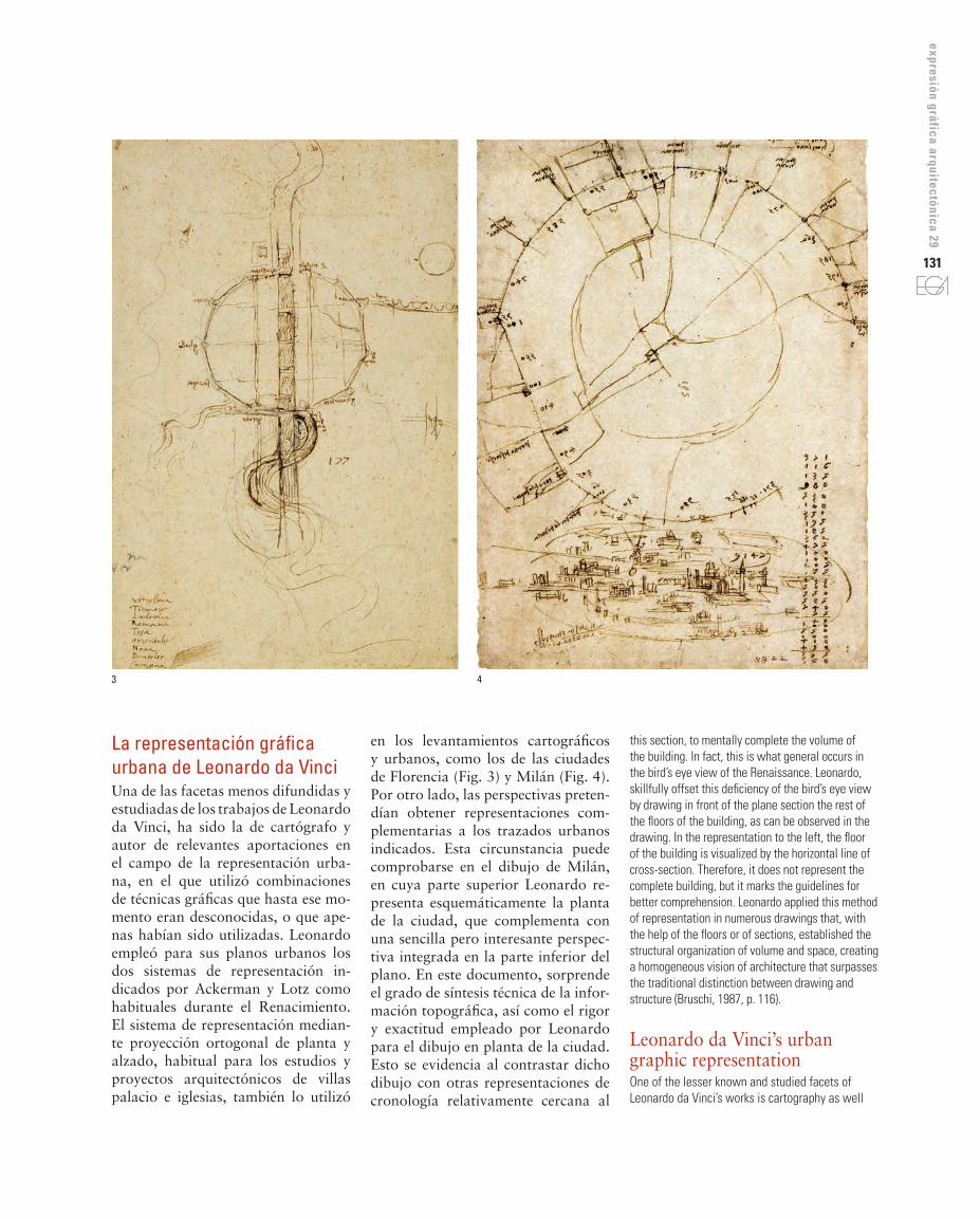
2. Representación a vista de pájaro de un edificio. Códice Atlántico, folio 205v-a (ca. 1505)3. Levantamiento esquemático de Florencia. Códice Windsor, folio RL 12681 (ca. 1515)4. Trabajos de remodelación de la ciudad de Milán. Códice Atlántico, folio 73v-a (1495)
2. Representation bird’s eye view of a building. Codex Atlanticus, page 205V-a (ca. 1505)3. Schematic representation of Florence. Codex Windsor, RL page 12681 (ca. 1515)4. Remodeling of the city of Milan. Codex Atlanticus, page 73v-a (1495)
representations were used to objectively describe the three dimensional reason for visual synthesis and his geometric configuration (Grassa-Miranda and Giménez Morell, 2010, p. 156), it was also frequent during this period to employ a double technique of representation that combined perpendicular projection and perspective:
In the early and central period of the Renaissance, the two usual methods of representation used for the interior space of architectural drawings are: perspective and orthogonal section projection (Lotz, 1985, p.1).
This circumstance had already been indicated before by James Ackerman in the study of the drawings of Leonardo integral in the Madrid Code II: “The drawings in this volume are of two kinds, two dimensional diagrams illustrating the teorical principles of the text, and isometric perspective rendering” (1977, p.48). However, the system of perspective representation used by Leonardo differs considerably from what is employed up until this moment by other architects and artists of the Renaissance. The difference, fundamentally resided in two matters: on one hand, the elevation of the point of view above ground level, what would permit him to obtain the best projection of the structure of the building, subtracts from the importance of the rest of the details; on the other hand, the modification of the centralized perspective toward a lateral perspective or cavalier, as it later came to be named. The first difference was enough to create the term bird”s eye view, and to consider it as one of the “first examples of this method traced systematically” (Lotz, 1985, p.8). In the superior segment of the document 205v-a of the Atlantic Code (Fig. 2), the exterior and interior view of the isolated building are shown by means of the cited method. It is worth giving special attention of that section of the building, represented in the left hand side of the figure. In this, the plane section is represented by the horizontal line that can be found situated at the ground level and is the commissioned to separate the represented part from the part that is not visible, that to the observer appear together. Following Lotz (1985), Alberti described this plane section, in spite of its opacity, outside of glass or other transparent materials, which permit one to see the interior of the building. If we do not take into account the representation of the metric volume places to the left of the figure, it could be perceived as a partial loss of information and result difficult, from only
interior del edificio a su través. Si no contáramos con la representación de la volumetría ubicada a la derecha de la figura, se podría percibir una pérdi-da parcial de información y resultaría difícil, partiendo sólo de la sección, completar mentalmente el volumen del edificio. De hecho, esto es lo que ocurre generalmente en las perspecti-vas a vista de pájaro realizadas en el Renacimiento. Leonardo, muy hábil-mente, compensó esta deficiencia de la perspectiva a vista de pájaro dibu-jando por delante del plano-sección el resto de la planta del edificio, tal y como se puede observar en el dibujo. En la representación de la izquierda se visualiza la planta del edificio por delante de la línea horizontal de sec-ción. De esta forma, no se representa el edificio completo, pero se marcan las directrices para una mejor com-prensión del mismo. Leonardo aplicó este método de representación en nu-merosos dibujos que, con el apoyo de la planta o de secciones, hicieron pa-tente la organización estructural del volumen y del espacio, contribuyendo a favorecer una visión homogénea de la arquitectura que supera la tradicio-nal distinción entre dibujo y estructu-ra. (Bruschi, 1987, p.116).
del nivel del suelo, lo que permitía obtener una mejor proyección de la estructura del edificio, restando importancia al resto de detalles; en segundo lugar, la modificación de la perspectiva centralizada hacia una perspectiva lateral o caballera, tal y como posteriormente se denomina-ría. La primera diferencia marcada fue suficiente para bautizar dicha re-presentación como perspectiva a vista de pájaro, y considerarla como uno de “los primeros ejemplos de este méto-do trazados sistemáticamente” (Lotz, 1985, p.8). En el segmento superior del folio 205v-a del Códice Atlántico (Fig. 2), se muestra la vista exterior e interior de un edificio aislado median-te el citado procedimiento. Conviene poner especial atención en la sección del edificio, representada a la izquier-da de la figura. En ella, el plano sec-ción viene representado por la línea horizontal que se encuentra ubicada a nivel de suelo y que es la encargada de separar la parte representada de la parte no visible, la cual quedaría jun-to al observador. Según Lotz (1985), Alberti describió este plano sección, como si a pesar de su opacidad, fue-ra de vidrio u otro material trans-parente, como permitiendo mirar el
2
131
expresión gráfica arquitectónica 29
this section, to mentally complete the volume of the building. In fact, this is what general occurs in the bird’s eye view of the Renaissance. Leonardo, skillfully offset this deficiency of the bird’s eye view by drawing in front of the plane section the rest of the floors of the building, as can be observed in the drawing. In the representation to the left, the floor of the building is visualized by the horizontal line of cross-section. Therefore, it does not represent the complete building, but it marks the guidelines for better comprehension. Leonardo applied this method of representation in numerous drawings that, with the help of the floors or of sections, established the structural organization of volume and space, creating a homogeneous vision of architecture that surpasses the traditional distinction between drawing and structure (Bruschi, 1987, p. 116).
Leonardo da Vinci’s urban graphic representationOne of the lesser known and studied facets of Leonardo da Vinci’s works is cartography as well
en los levantamientos cartográficos y urbanos, como los de las ciudades de Florencia (Fig. 3) y Milán (Fig. 4). Por otro lado, las perspectivas preten-dían obtener representaciones com-plementarias a los trazados urbanos indicados. Esta circunstancia puede comprobarse en el dibujo de Milán, en cuya parte superior Leonardo re-presenta esquemáticamente la planta de la ciudad, que complementa con una sencilla pero interesante perspec-tiva integrada en la parte inferior del plano. En este documento, sorprende el grado de síntesis técnica de la infor-mación topográfica, así como el rigor y exactitud empleado por Leonardo para el dibujo en planta de la ciudad. Esto se evidencia al contrastar dicho dibujo con otras representaciones de cronología relativamente cercana al
La representación gráfica urbana de Leonardo da VinciUna de las facetas menos difundidas y estudiadas de los trabajos de Leonardo da Vinci, ha sido la de cartógrafo y autor de relevantes aportaciones en el campo de la representación urba-na, en el que utilizó combinaciones de técnicas gráficas que hasta ese mo-mento eran desconocidas, o que ape-nas habían sido utilizadas. Leonardo empleó para sus planos urbanos los dos sistemas de representación in-dicados por Ackerman y Lotz como habituales durante el Renacimiento. El sistema de representación median-te proyección ortogonal de planta y alzado, habitual para los estudios y proyectos arquitectónicos de villas palacio e iglesias, también lo utilizó
3 4

132 as relevant contributions in the field of urban representation, which utilized combinations of graphic techniques that until that point in time were unknown, or were hardly used. In his urban plans, Leonardo employed two systems of representation by means of perpendicular projection of planes and elevation, a method regularly used in architectural studies and projects of town halls and churches, it was also used in cartographic developments and urban areas, like the cities of Florence (Fig. 3) and Milan (Fig. 4). On the other hand, these perspectives act as complementary representations of the urban designs indicated. This circumstance can be supported in the drawing of Milan, in its superior part, Leonardo schematically represents the ground level of the city, that complements with ease and interest the integrated perspective in the inferior part of the plan. In this document, the technique of the topical information is synthesized to a surprising degree, as well as the rigor and exactness employed by Leonardo in the plan of the city. This evidences the contrast between this drawing and other representations that are relatively close chronologically to the plan of Leonardo, but of a much more pictorial character (Chías Navarro, 2009, p. 54) and are similar to and urban ideogram, like the drawing of Pietro del Massaio in 1475 (Fig. 5), or later to the plan of Giulio Ballino in 1567 (Fig. 6).During the period of Cesar Borgia’s service, Leonardo carried out cartographic labors of the conquered regions. This activity served to perfect his system of representation of the bird’s eye view. Well known trades of this period were distinct topographical representations that appear in the Windsor Code 3 and in the Madrid Code II 4. The technicality of execution was created with black and colored ink, although the colors are dated later than the year 1500. These representations were pioneers in the birth of modern cartography 5 since Leonardo revolutionized the oblique view that was developed in the last centuries (Zollner, 2007), the asymmetry started to standout by means of different tones and intensities of color (Fig. 7). However, other researchers such as Mario Docci, sustain that Leonardo did not especially excel in the field of urban rises. For Docci (1987, pg. 75-78), Leonardo’s innovations in the field of graphic representation can be reduced into two groups: the contributions of the theories described in
en el origen de la cartografía moder-na 5 ya que Leonardo revolucionaría el sistema de vista oblicua que venía desarrollándose en los últimos siglos (Zollner, 2007), comenzando a resal-tar la altimetría mediante diferentes tonalidades e intensidades de color (Fig. 7). No obstante, otros investi-gadores como Mario Docci, sostienen que Leonardo no destacó especial-mente en el campo del levantamiento urbano. Para Docci (1987, pp.75-78), las innovaciones de Leonardo en el campo de la representación gráfica se reducen a dos grupos: las aporta-ciones de las teorías descritas en sus Códices, y las nuevas herramientas y métodos de medición empleados.
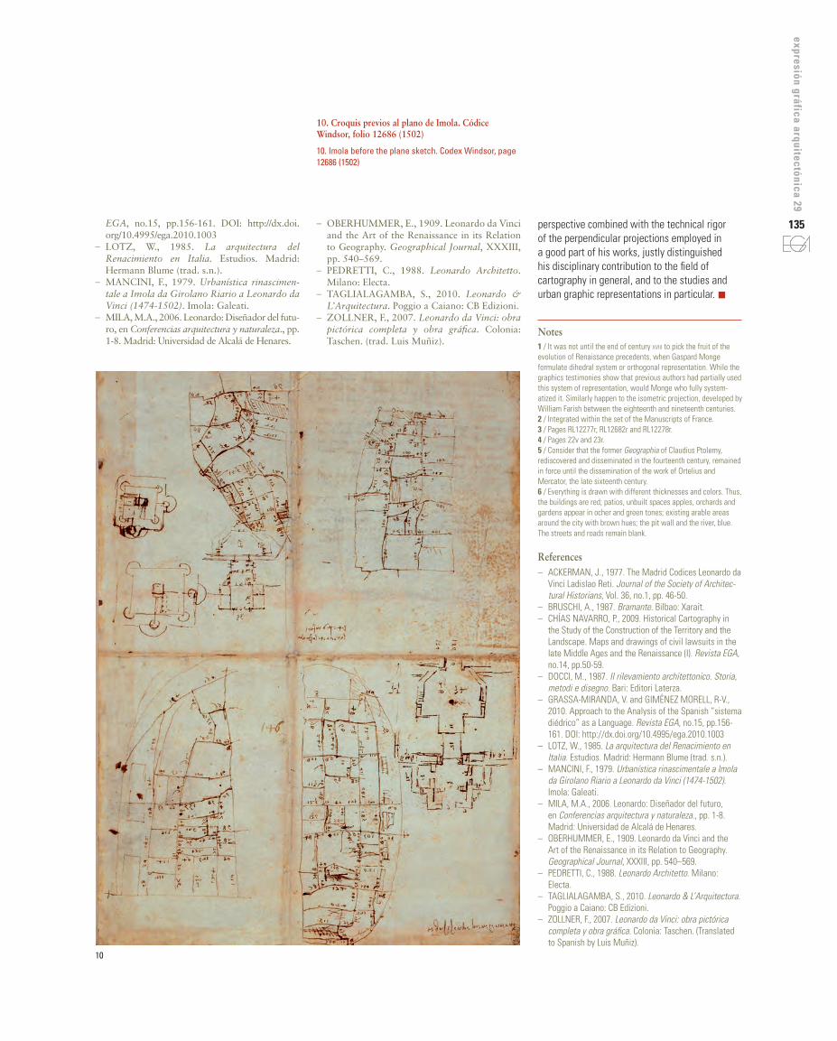
La representación urbana más des-tacable de Leonardo es la de Imola (Fig. 8), estudiada en la primera década del siglo xx por Eugen Oberhummer
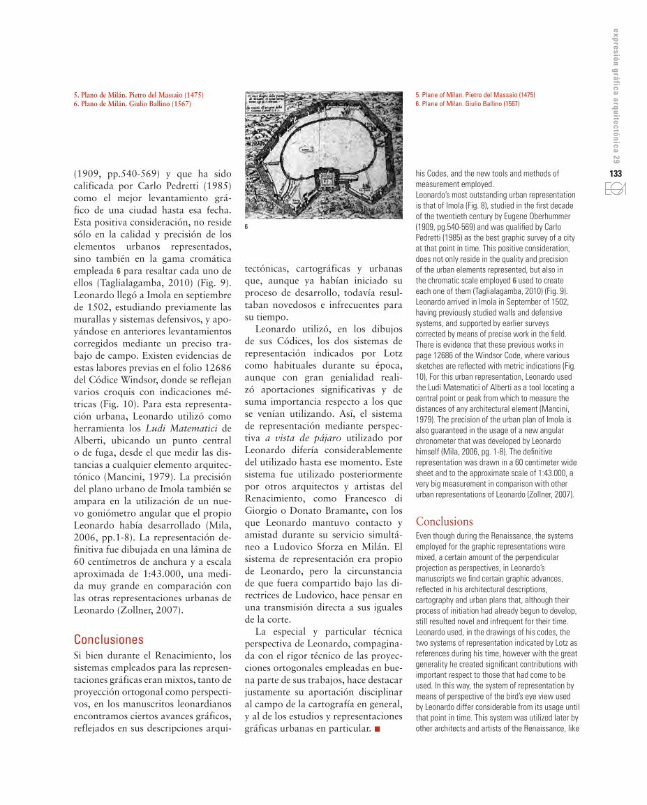
plano de Leonardo, pero de carácter mucho más pictórico (Chías Navarro, 2009, p.54) y aproximado a un ideo-grama urbano, como el dibujo de 1475 de Pietro del Massaio (Fig. 5), o el más tardío plano de Giulio Ballino de 1567 (Fig. 6).
Durante el periodo en que prestó servicio a César Borgia, Leonardo desempeñó labores cartográficas de las regiones conquistadas. Esta acti-vidad propició que perfeccionara su sistema de representación de perspec-tiva a vista de pájaro. Muestras no-torias de este periodo fueron las dis-tintas representaciones topográficas que aparecen en el Códice Windsor 3 y en el Códice Madrid II 4. La téc-nica de ejecución se realizaría con pluma en negro o a color, si bien las de color son posteriores al año 1500. Estas representaciones son pioneras
5
133
expresión gráfica arquitectónica 29
5. Plane of Milan. Pietro del Massaio (1475)6. Plane of Milan. Giulio Ballino (1567)
5. Plano de Milán. Pietro del Massaio (1475)6. Plano de Milán. Giulio Ballino (1567)
his Codes, and the new tools and methods of measurement employed.Leonardo’s most outstanding urban representation is that of Imola (Fig. 8), studied in the first decade of the twentieth century by Eugene Oberhummer (1909, pg.540-569) and was qualified by Carlo Pedretti (1985) as the best graphic survey of a city at that point in time. This positive consideration, does not only reside in the quality and precision of the urban elements represented, but also in the chromatic scale employed 6 used to create each one of them (Taglialagamba, 2010) (Fig. 9). Leonardo arrived in Imola in September of 1502, having previously studied walls and defensive systems, and supported by earlier surveys corrected by means of precise work in the field. There is evidence that these previous works in page 12686 of the Windsor Code, where various sketches are reflected with metric indications (Fig. 10), For this urban representation, Leonardo used the Ludi Matematici of Alberti as a tool locating a central point or peak from which to measure the distances of any architectural element (Mancini, 1979). The precision of the urban plan of Imola is also guaranteed in the usage of a new angular chronometer that was developed by Leonardo himself (Mila, 2006, pg. 1-8). The definitive representation was drawn in a 60 centimeter wide sheet and to the approximate scale of 1:43.000, a very big measurement in comparison with other urban representations of Leonardo (Zollner, 2007).
ConclusionsEven though during the Renaissance, the systems employed for the graphic representations were mixed, a certain amount of the perpendicular projection as perspectives, in Leonardo’s manuscripts we find certain graphic advances, reflected in his architectural descriptions, cartography and urban plans that, although their process of initiation had already begun to develop, still resulted novel and infrequent for their time.Leonardo used, in the drawings of his codes, the two systems of representation indicated by Lotz as references during his time, however with the great generality he created significant contributions with important respect to those that had come to be used. In this way, the system of representation by means of perspective of the bird’s eye view used by Leonardo differ considerable from its usage until that point in time. This system was utilized later by other architects and artists of the Renaissance, like
tectónicas, cartográficas y urbanas que, aunque ya habían iniciado su proceso de desarrollo, todavía resul-taban novedosos e infrecuentes para su tiempo.
Leonardo utilizó, en los dibujos de sus Códices, los dos sistemas de representación indicados por Lotz como habituales durante su época, aunque con gran genialidad reali-zó aportaciones significativas y de suma importancia respecto a los que se venían utilizando. Así, el sistema de representación mediante perspec-tiva a vista de pájaro utilizado por Leonardo difería considerablemente del utilizado hasta ese momento. Este sistema fue utilizado posteriormente por otros arquitectos y artistas del Renacimiento, como Francesco di Giorgio o Donato Bramante, con los que Leonardo mantuvo contacto y amistad durante su servicio simultá-neo a Ludovico Sforza en Milán. El sistema de representación era propio de Leonardo, pero la circunstancia de que fuera compartido bajo las di-rectrices de Ludovico, hace pensar en una transmisión directa a sus iguales de la corte.
La especial y particular técnica perspectiva de Leonardo, compagina-da con el rigor técnico de las proyec-ciones ortogonales empleadas en bue-na parte de sus trabajos, hace destacar justamente su aportación disciplinar al campo de la cartografía en general, y al de los estudios y representaciones gráficas urbanas en particular. n
(1909, pp.540-569) y que ha sido calificada por Carlo Pedretti (1985) como el mejor levantamiento grá-fico de una ciudad hasta esa fecha. Esta positiva consideración, no reside sólo en la calidad y precisión de los elementos urbanos representados, sino también en la gama cromática empleada 6 para resaltar cada uno de ellos (Taglialagamba, 2010) (Fig. 9). Leonardo llegó a Imola en septiembre de 1502, estudiando previamente las murallas y sistemas defensivos, y apo-yándose en anteriores levantamientos corregidos mediante un preciso tra-bajo de campo. Existen evidencias de estas labores previas en el folio 12686 del Códice Windsor, donde se reflejan varios croquis con indicaciones mé-tricas (Fig. 10). Para esta representa-ción urbana, Leonardo utilizó como herramienta los Ludi Matematici de Alberti, ubicando un punto central o de fuga, desde el que medir las dis-tancias a cualquier elemento arquitec-tónico (Mancini, 1979). La precisión del plano urbano de Imola también se ampara en la utilización de un nue-vo goniómetro angular que el propio Leonardo había desarrollado (Mila, 2006, pp.1-8). La representación de-finitiva fue dibujada en una lámina de 60 centímetros de anchura y a escala aproximada de 1:43.000, una medi-da muy grande en comparación con las otras representaciones urbanas de Leonardo (Zollner, 2007).
ConclusionesSi bien durante el Renacimiento, los sistemas empleados para las represen-taciones gráficas eran mixtos, tanto de proyección ortogonal como perspecti-vos, en los manuscritos leonardianos encontramos ciertos avances gráficos, reflejados en sus descripciones arqui-
6

134
7. Mapa del Norte de Italia. Códice Windsor, folio RL 12277r (1502)8. Representación gráfica de la ciudad de Imola. Códice Windsor, folio 12284 (1502)9. Fragmento y detalle cromático del plano de Imola. Códice Windsor, folio 12284 (1502)
7. Map of Northern Italy. Codex Windsor, page 12277r RL (1502)8. Graphical representation of the city of Imola. Codex Windsor, page 12284 (1502)9. Fragment and color detail Imola plane. Codex Windsor, page 12284 (1502)
Francesco di Giorgio or Donato Bramante, with those that maintained contact and friendship with Leonardo during his simultaneous service to Ludovico Sforza in Milan. The system of representation was Leonardo’s own, but the circumstances that were shared under the direction of Ludovico, provoke thought in a direct transmission to his equality in the field.Leonardo’s special and particular technique of
7
8
9
Notas1 / Habría que esperar hasta finales del s. xviii para recoger el fruto de la evolución de los precedentes renacentistas, cuando Gaspard Monge formulara el sistema de representación diédrico u ortogonal. Si bien los testimonios gráficos evidencian que autores anteriores habían empleado parcialmente este sistema de representación, sería Monge quien lo sistematiza-ría plenamente. De forma similar ocurriría con la pro-yección isométrica, desarrollada por William Farish entre los siglos xviii y xix.
2 / Integrado dentro del conjunto de los Manuscritos de Francia.3 / Folios RL12277r, RL12682r y RL12278r.4 / Folios 22v y 23r.5 / Tengamos en cuenta que la antigua Geographia de Claudio Ptolomeo, redescubierta y difundida en el siglo xiv, mantuvo su vigencia hasta la difusión de los traba-jos de Ortelius y Mercator, a finales del siglo xvi.6 / Todo se encuentra dibujado con distintos grosores y colores. Así, los edificios son de color rojo; los pa-tios, espacios no construidos de las manzanas, huer-tos y jardines aparecen en tonos ocres y verdosos; las áreas cultivables existentes alrededor de la ciudad con tonalidades marrones; el foso de la muralla y el río, azul. Las calles y caminos permanecen en blanco.
Referencias– ACKERMAN, J., 1977. The Madrid Codices
Leonardo da Vinci Ladislao Reti. Journal of the Society of Architectural Historians, Vol. 36, no.1, pp. 46-50.
– BRUSCHI, A., 1987. Bramante. Bilbao: Xarait.– CHÍAS NAVARRO, P., 2009. La cartografía his-
tórica en el estudio de la construcción del territo-rio y del paisaje. Mapas y dibujos de los pleitos civiles en la baja edad media y en el Renacimiento (I). Revista EGA, no.14, pp.50-59.
– DOCCI, M., 1987. Il rilevamiento architettonico. Storia, metodi e disegno. Bari: Editori Laterza.
– GRASSA-MIRANDA, V. y GIMÉNEZ MO-RELL, R-V., 2010. Aproximación al análisis del sistema diédrico español como lenguaje. Revista
135
expresión gráfica arquitectónica 29
10. Croquis previos al plano de Imola. Códice Windsor, folio 12686 (1502)
10. Imola before the plane sketch. Codex Windsor, page 12686 (1502)
perspective combined with the technical rigor of the perpendicular projections employed in a good part of his works, justly distinguished his disciplinary contribution to the field of cartography in general, and to the studies and urban graphic representations in particular. n
Notes1 / It was not until the end of century xviii to pick the fruit of the evolution of Renaissance precedents, when Gaspard Monge formulate dihedral system or orthogonal representation. While the graphics testimonies show that previous authors had partially used this system of representation, would Monge who fully system-atized it. Similarly happen to the isometric projection, developed by William Farish between the eighteenth and nineteenth centuries.2 / Integrated within the set of the Manuscripts of France.3 / Pages RL12277r, RL12682r and RL12278r.4 / Pages 22v and 23r.5 / Consider that the former Geographia of Claudius Ptolemy, rediscovered and disseminated in the fourteenth century, remained in force until the dissemination of the work of Ortelius and Mercator, the late sixteenth century.6 / Everything is drawn with different thicknesses and colors. Thus, the buildings are red; patios, unbuilt spaces apples, orchards and gardens appear in ocher and green tones; existing arable areas around the city with brown hues; the pit wall and the river, blue. The streets and roads remain blank.
References– ACKERMAN, J., 1977. The Madrid Codices Leonardo da
Vinci Ladislao Reti. Journal of the Society of Architec-tural Historians, Vol. 36, no.1, pp. 46-50.
– BRUSCHI, A., 1987. Bramante. Bilbao: Xarait.– CHÍAS NAVARRO, P., 2009. Historical Cartography in
the Study of the Construction of the Territory and the Landscape. Maps and drawings of civil lawsuits in the late Middle Ages and the Renaissance (I). Revista EGA, no.14, pp.50-59.
– DOCCI, M., 1987. Il rilevamiento architettonico. Storia, metodi e disegno. Bari: Editori Laterza.
– GRASSA-MIRANDA, V. and GIMÉNEZ MORELL, R-V., 2010. Approach to the Analysis of the Spanish “sistema diédrico” as a Language. Revista EGA, no.15, pp.156-161. DOI: http://dx.doi.org/10.4995/ega.2010.1003
– LOTZ, W., 1985. La arquitectura del Renacimiento en Italia. Estudios. Madrid: Hermann Blume (trad. s.n.).
– MANCINI, F., 1979. Urbanística rinascimentale a Imola da Girolano Riario a Leonardo da Vinci (1474-1502). Imola: Galeati.
– MILA, M.A., 2006. Leonardo: Diseñador del futuro, en Conferencias arquitectura y naturaleza., pp. 1-8. Madrid: Universidad de Alcalá de Henares.
– OBERHUMMER, E., 1909. Leonardo da Vinci and the Art of the Renaissance in its Relation to Geography. Geographical Journal, XXXIII, pp. 540–569.
– PEDRETTI, C., 1988. Leonardo Architetto. Milano: Electa.
– TAGLIALAGAMBA, S., 2010. Leonardo & L’Arquitectura. Poggio a Caiano: CB Edizioni.
– ZOLLNER, F., 2007. Leonardo da Vinci: obra pictórica completa y obra gráfica. Colonia: Taschen. (Translated to Spanish by Luis Muñiz).
– OBERHUMMER, E., 1909. Leonardo da Vinci and the Art of the Renaissance in its Relation to Geography. Geographical Journal, XXXIII, pp. 540–569.
– PEDRETTI, C., 1988. Leonardo Architetto. Milano: Electa.
– TAGLIALAGAMBA, S., 2010. Leonardo & L’Arquitectura. Poggio a Caiano: CB Edizioni.
– ZOLLNER, F., 2007. Leonardo da Vinci: obra pictórica completa y obra gráfica. Colonia: Taschen. (trad. Luis Muñiz).
EGA, no.15, pp.156-161. DOI: http://dx.doi.org/10.4995/ega.2010.1003
– LOTZ, W., 1985. La arquitectura del Renacimiento en Italia. Estudios. Madrid: Hermann Blume (trad. s.n.).
– MANCINI, F., 1979. Urbanística rinascimen-tale a Imola da Girolano Riario a Leonardo da Vinci (1474-1502). Imola: Galeati.
– MILA, M.A., 2006. Leonardo: Diseñador del futu-ro, en Conferencias arquitectura y naturaleza., pp. 1-8. Madrid: Universidad de Alcalá de Henares.
10