33963-papers44 esp ordenado viernes proceso de construcciÓn del arco mediterrÁneo: una calle de...
TRANSCRIPT


8 / Papers 44 / EL PROCESO DE CONSTRUCCIÓN DEL ARCO MEDITERRÁNEO: UNA CALLE DE DOBLE DIRECCIÓN
EL PROCESO DE CONSTRUCCIÓN DEL ARCO MEDITERRÁNEO: UNA
CALLE DE DOBLE DIRECCIÓN
SUMARIO
Introducción
1. Formulación del Arco Mediterráneo: un doble proceso1.1. La construcción europea, factor clave1.2. La nueva regionalización del territorio europeo1.3. La política regional europea: el punto de encuentro de los procesos top-down y las iniciativas bottom-up
2. A modo de conclusión
Bibliografía
Anexo. Iniciativas, estudios y proyectos de planifi cación territorial y de infraestructuras en relación con el Arco Mediterráneo

EL PROCESO DE CONSTRUCCIÓN DEL ARCO MEDITERRÁNEO: UNA CALLE DE DOBLE DIRECCIÓN / PLANIFICACIÓN DE INFRAESTRUCTURAS Y TERRITORIO. EL ARCO MEDITERRÁNEO / 9
Introducción
A lo largo de las últimas décadas, Europa ha sido in-terpretada desde varias visiones espaciales, que com-prenden desde las representaciones basadas en la diferenciación centro-periferia predominantes en los años setenta hasta otras más elaboradas a partir de la identifi cación de ejes, arcos y bananas que cubrían ex-tensas regiones del continente o, fi nalmente, hasta las que se fundaban en un sistema de relaciones en red. La representación de la Europa de las redes, necesaria para entender el creciente grado de complejidad en el que se producen las relaciones territoriales en el conti-nente, no permite obviar, sin embargo, la existencia de unos ejes articuladores, especialmente apropiados en el diseño y la dotación de infraestructuras de transporte y comunicaciones.
En este sentido, buena parte de las iniciativas comuni-tarias tendentes a favorecer el aumento de la compe-titividad territorial y la reducción de los desequilibrios (Estrategia Territorial Europea), de diseño y prioridad de redes transeuropeas de transporte (RTE-T), así como las surgidas de los propios territorios a partir de la cons-titución de ámbitos suprarregionales (eurorregiones, comunidades de trabajo), están enfocadas a responder a unas realidades funcionales que superan las fronteras de los propios Estados. En algunas ocasiones, estas realidades se reconocen y se organizan en forma de eurorregiones. En otras, constituyen simplemente ejes fuertemente integrados que contribuyen a articular el conjunto del territorio europeo desde el punto de vista funcional.
La Europa de los ejes y las eurorregiones se manifi esta, pues, como una realidad necesaria tanto para disponer de territorios con una masa crítica sufi ciente para desar-rollar un sistema de relaciones que requiere escalas más amplias como para articular el espacio europeo. En este contexto, el Arco Mediterráneo deviene, por su volumen de población y actividad económica y por su localización estratégica entre el continente y el Mediterráneo, un elemento clave que necesita ser interpretado como una unidad y ser dotado de las infraestructuras que garanti-cen su funcionamiento como tal. A fi n de comprender
lo que representa el Arco Mediterráneo en la actuali-dad es necesario conocer cuál ha sido su proceso de defi nición y, sobre todo, distinguir qué elementos han actuado como catalizadores de sus oportunidades y de sus potencialidades como espacio articulador del conti-nente europeo.
Como respuesta a esta necesidad se repasarán, en primer lugar, cuáles han sido los orígenes de la formu-lación de la idea de macrorregiones en Europa y, en particular, el papel determinante que han desempeñado en ella las políticas comunitarias, tanto las de responsa-bilidad directa (perspectivas de ordenación del territorio a escala continental, nuevos criterios para la política re-gional y para la asignación de fondos estructurales, etc.) como las de acompañamiento o de reconocimiento de iniciativas bottom-up (signifi cativamente los programas INTERREG). Políticas que, en algunos casos, se han simultaneado con los procesos de descentralización y reorganización político-administrativa de los Estados miembros.
En segundo lugar, se analizarán las posibles respues-tas, desde las escalas regionales y locales, a las nuevas opciones de políticas de desarrollo territorial elaboradas desde las instancias comunitarias. Respuestas que se propondrá articular a partir de la adopción de los para-digmas de la nueva regionalización regional, aproxima-ción conceptual y práctica para la construcción de nue-vas geografías de cooperación.
Las conclusiones terminarán recomendando a los ac-tores territoriales del Arco Mediterráneo la aplicación de los nuevos paradigmas y el desarrollo de las nuevas oportunidades que ofrece la interacción entre estos dos procesos (top-down y bottom-up) para la construcción del espacio macrorregional, a fi n de superar el actual estadio, todavía embrionario y poco articulado, pero en el que ya han aparecido una serie de iniciativas que se describen brevemente en el anexo.
EL PROCESO DE CONSTRUCCIÓN DEL ARCO MEDITERRÁNEO: UNA CALLE DE DOBLE DIRECCIÓN1
FRANCESC CARBONELLJOSEP BÁGUENA
Institut d’Estudis Regionals i Metropolitans de Barcelona
1 Traducido del original catalán.

10 / Papers 44 / EL PROCESO DE CONSTRUCCIÓN DEL ARCO MEDITERRÁNEO: UNA CALLE DE DOBLE DIRECCIÓN
1. Formulación del Arco Mediterráneo: un doble proceso2
El concepto de Arco entendido como eje de desarrollo se formuló por primera vez en 1973 con el nacimiento de la Conferencia de las Regiones Periféricas Maríti-mas, que reunió a 65 regiones europeas con el objetivo común de elaborar estrategias para ejercer de contra-peso a las grandes concentraciones humanas y econó-micas del centro de Europa3. Desde esta declaración de intenciones, no es hasta 19924 que encontramos la concreción del Arco Mediterráneo en los documentos de la Comisión Europea previos a la elaboración de la Estrategia Territorial Europea (Potsdam, 1999) como respuesta a la exigencia de contrapesar la dorsal ur-bana y económica centroeuropea defi niendo nuevos espacios de potencialidad. No obstante, la iniciativa en la formulación de este nuevo espacio no responde ex-clusivamente a un diseño estratégico de reequilibrio te-rritorial por parte de la Comisión Europea. Los estudios realizados desde los años ochenta que habían analizado las dinámicas de desarrollo del sistema urbano europeo ya habían destacado el nacimiento de nuevos ejes de desarrollo alternativos al eje norte-sur de la megalópolis centroeuropea, entre los que se encontraba la dorsal mediterránea5. El Arco Mediterráneo debía tener, de acuerdo con estos estudios, un papel protagonista en Europa6.
En el proceso histórico de materialización del Arco Me-diterráneo se observan, en síntesis, dos procesos y dos realidades paralelas:
1. Por una parte, la voluntad expresa de diferentes regio-nes europeas, y posteriormente de la propia Comisión Europea, de crear polos de desarrollo alternativos al centro (top-down).
2. Por otra, la colaboración de una trama de regiones y ciudades alrededor del Mediterráneo occidental con un claro potencial de desarrollo económico (bottom-up).
Parece, pues, pertinente preguntarse a continuación, más allá de la observación de las realidades y las exis-tencias, cuáles han sido los mecanismos de consolida-ción de potenciales transnacionales y transfronterizos en esta construcción de doble dirección.
1.1. La construcción europea, factor clave
Para las dinámicas top-down, la respuesta es sufi ciente-mente directa. Con la entrada de España, Portugal y Gre-
cia en la Comunidad Europea en los años ochenta, los procesos de integración experimentan una notable ace-leración. La perspectiva del mercado único hace cam-biar radicalmente la visión de la frontera. De la frontera como expresión de límite nacional, más allá del cual no se plantea ningún tipo de política de desarrollo territorial, se pasa a la frontera como espacio de articulación y de génesis de realidades transnacionales7.
A partir de este primer paso y a través de mecanismos de fomento de cooperación territorial, la Unión Europea marcó de forma decisiva el camino para la emergencia del Arco Mediterráneo. Entre las decisiones ratifi cadas por la Unión y por los respectivos ministros de los Es-tados miembros, fue particularmente relevante la adop-ción de unos principios rectores que pasaron a formar parte de la nueva política informal de ordenación del territorio en Europa. Estos principios han dado lugar pro-gresivamente a nuevas confi guraciones espaciales, a nuevos imaginarios geográfi co-económicos, cuya discu-sión ya ha representado por sí misma un ejercicio de co-laboración y construcción europea. Veamos brevemente cuál ha sido el proceso seguido.
Los informes Europa 2000 y Europa 2000+, elaborados por la DG XVI de la Comisión Europea en los años 1992 y 1994, respectivamente, fueron un primer ensayo de pensar la construcción del territorio europeo a una esca-la diferente. A modo de ejemplo, en el primero de am-bos documentos ya se anticipaba que “la creación de una Europa sin fronteras acelerará las transformaciones de los sistemas económicos regionales e intensifi cará las relaciones entre las regiones pertenecientes a Es-tados diferentes. Es preciso anticiparse a este proceso constituyendo redes de cooperación e inscribiendo la ordenación del territorio (de los Estados) en un marco más amplio”. Asimismo, se recomendaba especialmente un nuevo énfasis de esta cooperación en el nivel interre-gional, aunque todavía no se proponían ni delimitaban de antemano agrupaciones regionales fi jadas, sino que se promovía, de entrada, la elaboración de visiones de desarrollo territorial desde abajo (bottom-up), no encor-setadas por los contornos de las fronteras nacionales.
Esta hornada de perspectivas territoriales transnacio-nales, de las que el Arco Mediterráneo tenía que ser un producto natural, consiguió generar un cuerpo de pen samiento innovador sobre lo que debía signifi car, a efectos prácticos, la integración europea y cómo podían participar en ella, de manera casi cotidiana, los niveles regional y local. El segundo documento, Europa 2000+, avanzó propuestas en una doble vertiente: por una par-te, intensifi car las interrelaciones entre los diferentes territorios de la Unión y, por otra, empezar a defi nir los criterios de cooperación con una futura Europa ampliada sobre la base de un planeamiento espacial del continen-te considerado como un todo.
2 Para este trabajo se han considerado las iniciativas o aportaciones en la definición de Arco Mediterráneo planteadas en una lógica de intervención europea y transnacional. No se han considerado, pues, otras aportaciones, españolas o francesas, en las que se definen ejes de desarrollo de las respectivas regiones mediterráneas.
3 Cabodi, 1998.4 Europa 2000 y, posteriormente, Europa 2000+.5 Entre estos estudios hay que destacar los elaborados por R. Brunet, G. Dematteis,
A. Bagnasco, N. Cattan y A. Vanolo.6 Juan, 1994. 7 Balme, 1995.

EL PROCESO DE CONSTRUCCIÓN DEL ARCO MEDITERRÁNEO: UNA CALLE DE DOBLE DIRECCIÓN / PLANIFICACIÓN DE INFRAESTRUCTURAS Y TERRITORIO. EL ARCO MEDITERRÁNEO / 11
Este itinerario de elaboración y discusión de documen-tos-marco sobre la ordenación territorial de Europa con-dujo, fi nalmente, a la adopción, en el verano de 1999, en Potsdam, de la Estrategia Territorial Europea, más conocida por las iniciales de su título en inglés: ESDP (European Spatial Development Perspective). El informe fi jó con más claridad una serie de procesos que seguir para producir las nuevas visiones territoriales de Europa a partir de la constitución de grandes asociaciones ma-crorregionales. Las propuestas de la ESDP se sustentan sobre los tres principios rectores básicos que, como se ha comentado, acabarán siendo decisivos en la orienta-ción de las políticas europeas informales de ordenación del territorio: la cohesión económica y social, el desarro-llo sostenible y la competitividad equilibrada. Tres prin-cipios que en la última documentación comunitaria se han resumido en uno solo, la cohesión territorial, y cuya aplicación concreta se transmite a través de las siguien-tes policy options.
– Fortalecer algunas grandes zonas de integración eco-nómica en la Unión Europea, equipadas con servicios y funciones globales de alta calidad, incluyendo las áreas periféricas mediante estrategias de desarrollo espacial transnacional.
– Fortalecer un sistema más equilibrado y policéntrico de ciudades-regiones metropolitanas, city clusters y redes de ciudades mediante la cooperación entre la política estructural y la política de redes transeuropeas, y la mejora de los vínculos entre redes de transporte internacionales-estatales y regionales-locales.
– Promover estrategias de desarrollo espacial integra-das por las city clusters, dentro de un esquema de cooperación transnacional y transfronteriza, incluyen-do las correspondientes áreas rurales y sus pequeñas ciudades y pueblos.
– Impulsar la cooperación sobre determinados asuntos en el campo del desarrollo espacial a través de las re-des transnacionales y transfronterizas.
– Promover la cooperación en las escalas regionales, transnacionales y transfronterizas, entre ciudades y pueblos de los países del norte, centro y este de Europa y de la región mediterránea, impulsando las relaciones norte-sur en Europa central y las relaciones este-oeste en el norte de Europa.
A partir de esta posición innovadora en materia de coope-ración territorial que propone la ESDP, es cuando se mo-difi can y se amplían los esquemas mentales para pensar nuevas geografías funcionales del espacio europeo, y adquiere todo el sentido la construcción de una visión de conjunto del Arco Mediterráneo. A través de la articulación de estos grandes conjuntos económicos macrorregionales es como se podrá componer, pieza por pieza, el rompeca-bezas territorial de la economía eu ropea.
De este modo, el Arco Mediterráneo, o bien el Arco Alpi-no o el Mediterráneo central, se transformarán en terri-torios transfronterizos en gestación, nuevos territorios posibles basados en solidaridades de carácter geográ-fi co y a los que será preciso facilitar la consolidación8. En síntesis, pues, hemos comprobado que Europa ha desempeñado un papel fundamental en la emergencia del Arco Mediterráneo en tanto que referente (Merca-do Único, ESDP) y en tanto que agente institucional (Dirección General de Política Regional de la Comisión Europea). Veremos a continuación como, siguiendo el principio de acción-reacción, las reglas del juego for-muladas de arriba abajo han sido y pueden ser reformu-ladas de abajo arriba a través de iniciativas renovadas desarrolladas por las instancias políticas o económicas regionales o locales. Es el proceso denominado nueva regionali zación.
1.2. La nueva regionalización del territorio europeo
Tal como explica Josep V. Boira (2002), el concepto de regionalización puede variar en función de la defi nición de región que se emplee. Para entender las nuevas di-námicas territoriales europeas propone que se trabaje con regiones económicas; o sea, con las que están esta-blecidas por la realidad de los fl ujos y de las relaciones. Según Dematteis (2002), estas nuevas unidades econó-micas territoriales son, sobre todo, construcciones inten-cionales. En otras palabras, los espacios de colaboración macrorregionales son una respuesta, una reinvención de los territorios, para incrementar la masa crítica y las oportunidades de interacción en una economía globaliza-da; son los auténticos entes territoriales de futuro para la toma de decisiones, los nuevos sujetos activos de la vida política, pública y económica.
En la creación voluntarista de estos nuevos espacios, las oportunidades de interacción de la escala regional-local con la global son más posibles y directas que nun-ca. Las regiones, las colectividades locales, los empre-sarios, las universidades y las escuelas, los sectores económicos, pueden participar y participan en el juego de relaciones internacionales de la política, la econo-mía, el pensamiento y el mercado, sin pasar por la si-guiente escala administrativa en términos de jerarquía ordinal.
Este nuevo planteamiento de las relaciones territoriales, que supone una nueva forma de pensar y actuar, com-porta haber entendido previamente una serie de nuevos paradigmas y nuevas oportunidades:
– Los territorios, sus gobiernos y sus agentes tienen, cada vez más, la posibilidad de organizarse de forma horizontal o en red. Para responder a los nuevos retos de la globalización y la reestructuración económica que se deriva de ella, el sistema de relaciones entre ciuda-
8 Báguena, 2001.

12 / Papers 44 / EL PROCESO DE CONSTRUCCIÓN DEL ARCO MEDITERRÁNEO: UNA CALLE DE DOBLE DIRECCIÓN
des y regiones se reorganiza con conexiones más di-rectas, no piramidales, entre los diferentes elementos.
– La nueva organización en red se basa fundamental-mente en el potencial de los actores regionales y loca-les, en el desarrollo endógeno.
– Es necesario –ya se ha dicho con otras palabras– ges-tionar las interdependencias entre territorios, sus pro-yectos y estrategias comunes, sus complicidades. En el ámbito del Arco Mediterráneo es preciso, por ejem-plo, superar actitudes demasiado pasivas o meramen-te descriptivas y avanzar hacia otras más proactivas y propositivas.
– Hay que profundizar en las nuevas posibilidades de co-laboración regional y local en todos los ámbitos de la vida pública, social y económica europea e integrar el lobbying como esquema de funcionamiento para de-fender, al mismo tiempo, los intereses particulares y generales de la macrorregión del Arco Mediterráneo.
Así, continúa J. V. Boira, y de acuerdo con las premisas de esta nueva regionalización intencional, la idea de Arco Mediterráneo, “el modelo de este nuevo territorio inmediato, activo y geopolítico”, no debería descansar de forma exclusiva “en procesos de conformación territorial clásicos –en defi nitiva, en procesos de construcción na-cional–, sino en formulaciones más funcionalistas que, en parte, ya se han ensayado en Europa en los últimos años” (Boira, 2002). El problema surge, no obstante, cuando por parte de los agentes que supuestamente tienen que contribuir a construir y a fortalecer las rela-ciones en este nuevo espacio, se desconoce lo que está ocurriendo en Europa “en materia de colaboración regio-nal, de asociación económica y empresarial, de ordena-ción común del territorio” (Boira, 2002). Se desconoce, por ejemplo, que las “nuevas espacialidades” que se es-tán conformando en Europa en diferentes escalas, este nuevo diseño cartográfi co y económico del territorio, se basa, como se ha dicho más arriba, en la interacción en-tre las reglas de un planeamiento espacial europeo por encima y la respuesta de una cooperación económica a escala regional y local que nace desde abajo. Se des-conoce también, se ha olvidado o, sencillamente, se ha ignorado voluntariamente, la necesidad de este doble “esfuerzo creativo en materia de territorio”. Por una par-te, no ha habido el menor indicio de adopción de puntos de vista comunes respecto a la ordenación del territorio y, por otra, por el hecho de no conseguir la materializa-ción efectiva de las nuevas espacialidades, tampoco se ha derivado de ello ninguna forma nueva de cooperación ni de gobernación en esta geografía más amplia. Otra vez en palabras de Boira: no ha aparecido la necesidad de un nuevo (euro)regionalismo regional.
La aparición de este concepto va aparejada al papel de los territorios regionales como unidades de análisis económi-co, de toma de decisiones políticas y de aplicación de los
principios de ordenación y desarrollo territorial. Boira utiliza la defi nición propuesta por Mace y Thérien (1996), en la que regionalismo es entendido como “un proceso que se da en una región geográfi ca determinada por el que diferentes tipos de actores (estados, instituciones regionales, orga-nizaciones sociales) ponen en común y comparten valores fundamentales. Estos actores también participan en un cre-cimiento en red de interacciones económicas, culturales, científi cas, diplomáticas [...]. Aunque la progresión puede no ser automática y puede variar la velocidad en cada uno de los sectores afectados, la combinación de crecientes interacciones y valores compartidos no produciría necesa-riamente una nueva unidad política, sino más bien una más fuerte y más diversifi cada capacidad de gestión y decisión de los problemas regionales”. Los elementos que caracteri-zarían esta nueva acepción de regionalismo serían:
1. Que se trata de un proceso.
2. Que involucra a muchos agentes de distinta proceden-cia, no sólo a las instituciones u órganos de gobierno.
3. Que da prioridad al trabajo en red frente a las relacio-nes jerárquicas.
4. Que combina las interacciones más funcionales o eco-nómicas con los valores compartidos.
5. Que admite ritmos diferentes para los distintos secto-res de la economía o de la vida social.
6. Que preconiza, sobre todo, el aumento y la organiza-ción de la capacidad de afrontar los problemas regio-nales e internacionales antes que la creación de una nueva realidad jurídica y gubernamental superpuesta.
Así, después del regionalismo de escala estatal que conformó la CEE en los años cincuenta del siglo pasado o la UE de los años noventa, y de los procesos más o menos intensos de devolution en el interior de cada Es-tado miembro, nos encontraríamos en una tercera etapa de nuevo regionalismo regional, que habría empezado como una expresión transestatal y transfronteriza, ar-ticulando espacios semiadministrativos, pero que bien podría continuar en cada Estado.
La materialización de esta construcción de nuevos es-pacios de toma de decisiones y de cooperación tendría que transmitirse a través de la adopción de una verda-dera agenda regional. Una agenda regional entendida no como una suma de declaraciones, reuniones y cumbres –que es lo que en buena medida ha sido el centro de actividad de asociaciones como la Comunidad de Traba-jo del Pirineo, la Eurorregión Pirineos Mediterráneo o el Arco Latino, por poner tres ejemplos de ámbitos territo-riales y representaciones institucionales distintas–, sino como la plasmación efectiva de visiones multilaterales sobre la economía, la vida social, la política y la ordena-ción del nuevo territorio por construir.

EL PROCESO DE CONSTRUCCIÓN DEL ARCO MEDITERRÁNEO: UNA CALLE DE DOBLE DIRECCIÓN / PLANIFICACIÓN DE INFRAESTRUCTURAS Y TERRITORIO. EL ARCO MEDITERRÁNEO / 13
Posibles temas de la nueva agenda regional del Arco Mediterráneo –algunos de los cuales, como era de es-perar, ya forman parte de grupos de trabajo constitui-dos, por ejemplo, en el seno del Arco Latino o de la Comisión Intermediterránea de la Conferencia de Re-giones Periféricas y Marítimas (CRPM)– tendrían que ser:
– La gestión del litoral, característica fi siográfi ca compar-tida, que debería ser tratada en coordinación con las políticas de turismo, conservación del medio, pesca y recursos naturales, puertos y transporte marítimo.
– El agua, como factor estratégico en la cuenca medite-rránea.
– Las comunicaciones y las redes de transporte, por su infl uencia en la calidad de vida y la competitividad eco-nómica de los territorios.
– La estructura económica compartida, conjunción tanto de elementos puramente económicos como territoria-les y culturales.
– La construcción de un nuevo espacio geopolítico des-de el que reconsiderar las relaciones con los Estados miembros de los que forma parte el Arco Mediterrá-neo y con Europa.
– La ordenación territorial, la planifi cación de los usos y la preservación de los espacios naturales desde una perspectiva suprarregional.
Además de una gran diversidad de otras cuestiones, cuando menos del mismo grado de importancia, depen-diendo del territorio afectado, como podrían ser: la red de ciudades, la inmigración, el mercado laboral, el apoyo a la internacionalización de las empresas, los sectores industriales compartidos, el modelo comercial, la cons-titución de un frente portuario y de una política aeropor-tuaria común, la presión turística, la política agraria, la cooperación cultural, etc.
Boira, inspirándose en el concepto de spatial suicide, acuñado por Calthorpe y Fulton (2001) –concepto re-ferido por los autores a las áreas metropolitanas nor-teamericanas que han optado por no adherirse a la ne-cesidad de crear una macrorregión económica–, llega a pronosticar problemas graves a medio y largo plazo derivados de la falta de una visión conjunta del Arco Mediterráneo, sensiblemente en el campo económico y material (infraestructuras, ordenación del territorio, etc.). Para completar la descripción del paradigma de la nueva regionalización y para poder juzgar mejor la conveniencia, necesidad o urgencia de la cooperación económica y material entre los diferentes territorios que componen el Arco Mediterráneo, veremos qué aspectos, siempre según los mismos autores, se reco-mienda considerar:
1. Los efectos externos de las decisiones de los territorios vecinos. La creciente integración política y económica de los territorios conduce al aumento de la dependen-cia e interferencia de las dinámicas económicas y so-ciales de unos territorios con las de los otros.
2. La conveniencia de construir infraestructuras en un esquema de red. La accesibilidad es, como se ha di-cho, un factor clave para mejorar la competitividad de un territorio. Es, de pleno derecho, parte constitutiva de lo que la OCDE denomina “capital territorial”. En el caso de unidades territoriales pequeñas como las que componen el mosaico del Arco Mediterráneo, la accesibilidad depende casi siempre de los otros, por lo cual resulta aún más imprescindible la adopción de una política de cooperación.
3. La necesidad de evitar, mediante la cooperación, la competición gravosa con los territorios vecinos. Se tra-ta de practicar lo que algunos autores han denominado co-opetition; esto signifi ca, para territorios pequeños, reservar la competencia sólo para los campos en los que pueden darse situaciones win-win y cooperar, en cambio, en aspectos como las grandes infraestructu-ras de comunicación, elementos de elevado coste que en caso de duplicarse inútilmente podrían conducir a un agotamiento de los recursos fi nancieros para otras necesidades, o bien en determinados sectores econó-micos como el turismo, en los que una competencia encarnizada podría derivar en un impacto negativo so-bre el medio ambiente hasta llegar a comprometer un recurso necesario en el futuro para el propio éxito y la viabilidad de las empresas relacionadas.
4. El incremento probado de la efi ciencia económica de-rivada de la cooperación. El ejemplo de las sinergias económicas derivadas de la constitución del mercado común europeo son la mejor demostración de ello.
5. La necesaria capacidad de presión (lobbying). La co-ordinación de políticas y la colaboración de actuacio-nes públicas y sectores privados permite ensanchar la capacidad de infl uencia ante las instancias de poder estatales y supraestatales.
1.3. La política regional europea: el punto de encuentro de los procesos top-down y las iniciativas bottom-up
La Dirección General de Política Regional de la Comi sión Europea ofrece un reconocimiento ofi cial y un marco organizativo a una dinámica asociativa de impulso de iniciativas de reconocimiento territorial más allá de las fronteras regionales y nacionales en una lógica del ti-po bottom-up. Este reconocimiento se manifi esta con el Programa de Iniciativa Comunitaria INTERREG9. El
9 INTERREG es un programa que se enmarca en los Fondos Estructurales de la Unión Europea destinado a fomentar la cooperación transfronteriza, transnacional e interregional.

14 / Papers 44 / EL PROCESO DE CONSTRUCCIÓN DEL ARCO MEDITERRÁNEO: UNA CALLE DE DOBLE DIRECCIÓN
objetivo fundamental del programa INTERREG es no tanto fomentar el desarrollo de regiones transfronteri-zas como el de acompañar simbólicamente, y en cierta medida fi nancieramente, iniciativas de reconocimiento de intereses comunes10.
El ejemplo de la iniciativa INTERREG u otros programas de los Fondos Europeos de Desarrollo Regional (FEDER) nos permiten afi rmar que los dos procesos de formulación del Arco Mediterráneo mencionados –por una parte, un pro-gresivo reconocimiento de la Unión Europea de realidades transnacionales y, por otra, una articulación de territorios con un potencial de desarrollo transfronterizo que hemos denominado nueva regionalización– han ido convergiendo hasta la creación de mecanismos formales.
2. A modo de conclusión
La pretensión de este artículo ha sido mostrar, por una parte, el proceso histórico de elaboración de unos prin-cipios rectores por parte de la UE para la articulación territorial del continente europeo y, por otra, las posibles vías de respuesta, desde las escalas regionales y loca-les, a estos retos lanzados en las instancias comunita-rias. Respuesta canalizada a través de la adopción de los
nuevos paradigmas para la construcción de geografías de cooperación que hemos convenido en denominar nueva regionalización.
Por parte de los actores territoriales del Arco Medite-rráneo, el desarrollo de las nuevas oportunidades que ofrece la interacción entre estos dos procesos todavía es totalmente embrionario o simplemente se descono-ce. En buena medida por falta de una tradición de largo recorrido por lo que respecta a la cooperación entre ve-cinos; como sería el caso, por ejemplo, de las ciudades y regiones del mar Báltico.
No obstante, las bases conceptuales de la forma de construir estas nuevas territorialidades ya han sido defi -nidas. Existen también, como acabamos de mencionar, buenas prácticas de cooperación en las que refl ejarse. Ha habido, asimismo, un goteo de iniciativas (véase Anexo) que se ha ido desarrollando, aunque hasta ahora de forma poco articulada. Por tanto, parece llegado el momento de hacer de la necesidad virtud y de aplicar los consejos de la nueva regionalización para edifi car la realidad macrorregional del Arco Mediterráneo, para construir la nueva masa crítica que piden tanto los pro-cesos de integración europea como los procesos de in-ternacionalización de la economía.
Bibliografía
Báguena, J. (2001); Les politiques transfrontalières d’aménage-ment du territoire. Politique européenne et dynamiques terri-toriales autour des espaces frontaliers. Mémoire DEA. Institut d’Urbanisme de Grenoble.
Balme, R. (1995); Les politiques du néorégionalisme. Paris, Eco-nomica, Collection Politique Comparée.
Boira, J.V. (2002); Euram 2010. La via europea, València, edi-cions 3i4.
Brunet, R. (1996); “L’Europe des réseaux”, en D. Pumain y Th. Saint-Julien (dir.), Networks in Europe, John Libbey Eurotext.
Cabodi, C. (1998); “L’Arco latino mediterraneo nel contesto eu-ropeo”, a Bonavero, P. y Dansero, E. (eds.) L’Europa delle regioni e delle reti. I nuovi modelli di organizzazione territoriale nello spazio unifi cato europeo, Torino, UTET Libreria.
Calthorpe, P. y W. Fulton (2001); The Regional City: planning for the end of sprawl, Washington, D.C., Island Press.
CRPM (2002); Étude sur la construction d’un modèle de déve-loppement polycentrique et équilibré du territoire européen, CD ROM, www.crpm.org
Dematteis, G. (1996), “Towards a unifi ed metropolitan urban system in Europe”, en D. Pumain y Th. Saint-Julien (dir.), Net-works in Europe, John Libbey Eurotext.
Dematteis, G. (2002); “De las regiones-área a las regiones-red. Formas emergentes de gobernabilidad regional” en J. Subirats (coord.) Redes, territorios y gobierno. Nuevas respuestas lo-cales a los retos de la globalización, Barcelona, Diputación de Barcelona.
ESDP (1999); Towards Balanced and Sustainable Development of the Territory of the European Union (Agreed at the Informal Council of Ministers responsible for Spatial Planning in Pots-dam, mayo, 1999), Bruselas, Comisión Europea.
GIP-RECLUS (1989); Les Villes Européennes, informe para DA-TAR. París, La Documentation Française.
Juan, J.-C. (1994); “L’arc méditerranéen: un espace en devenir”, Mediterranée, 1-2, págs. 7-14.
Mace, G. y J.-P. Thérien (1996); Foreign policies and regionalism in the Americas, Boulder, Lynne Rienner.
Rivière, D. (2005); “L’Arc méditerranéen, un «objet européen» à la recherche de son identité” Actes du Festival International de Géographie, Saint-Dié des Vosges.
10 Rivière, 2005.

EL PROCESO DE CONSTRUCCIÓN DEL ARCO MEDITERRÁNEO: UNA CALLE DE DOBLE DIRECCIÓN / PLANIFICACIÓN DE INFRAESTRUCTURAS Y TERRITORIO. EL ARCO MEDITERRÁNEO / 15
Anexo. Iniciativas, estudios y proyectos de planifi cación territorial y de infraestructuras en relación con el Arco Mediterráneo
Relacionamos a continuación algunas de las aportacio-nes más signifi cativas y a la vez más próximas a la reali-dad catalana en la construcción del Arco Mediterráneo. Son aportaciones que ejemplifi can la génesis, a veces europea, a veces regional y/o local del proyecto; la vo-luntad de materializar un potencial latente de desarrollo y la adaptación de la noción de Arco Mediterráneo a una gran variedad de objetivos.
a) Proyectos e iniciativas comunitarias – Estrategia Territorial Europea – Iniciativa-Programa INTERREG
b) Proyectos compartidos entre comunidades autónomas – Eurorregión Pirineos-Mediterráneo
c) Proyectos compartidos entre administraciones locales – Arco Latino – Red C-6
d) Proyectos e iniciativas de la sociedad civil – FERRMED – Euram
En segundo lugar, para describir y caracterizar some-ramente, así como para permitir una cierta compa-ración entre las diferentes iniciativas se presenta la información sintetizada en una serie de tablas en las que se indica para cada caso: ámbitos territoriales fun-cionales, administraciones impulsoras, contenidos y direccionalidad institucional y reconocimiento de cada iniciativa.
En tercer lugar, para poder verifi car algunos de los ar-gumentos expuestos en el artículo, se adjuntan unas matrices de descripción en las que se conjuga la esfera institucional (columnas) y la esfera operativa (fi las) de cada iniciativa. La planifi cación territorial y de infraestruc-turas centran la atención de la descripción por el hecho de que estos dos ámbitos de actuación son analizados por la mayoría de iniciativas y se convierten, pues, en el denominador común entre las diferentes propuestas de Arco Mediterráneo.
FIGURA 1 Relación entre agentes promotores y ámbitos de actuación
Políticaregional
Planifi caciónterritorial
Planifi cación deinfraestructuras
UniónEuropea
Región/CC.AA
Administraciónlocal
Sociedadcivil
Arco M
editerráneoETE
INTERREG Eurorregión
Pirineos-Mediterráneo
Arco Latino C-6 Euram
FERRMED

16 / Papers 44 / EL PROCESO DE CONSTRUCCIÓN DEL ARCO MEDITERRÁNEO: UNA CALLE DE DOBLE DIRECCIÓN
Fuente: Elaboración propia.
FIGURA 3 Estrategia Territorial Europea (ETE) /European Spatial Development Perspective (ESDP)
Esfera institucional
Nueva política Nuevos marcos Representación Objeto (infraestructura / regional territoriales institucional / política planeamiento)
Origen de la Consejo de Europa
propuesta
Mediterráneo Escala /Ámbito occidental-Alpes latinosterritorial (CC.AA defi nidas por los Estados)
Institución Consejo de Europa en promotora coordinación con de soporte los Estados
Contenido Desarrollo espacial Infraestructura
Policentrismo, Planeamiento Equilibrio territorial territorial Sostenibilidad
Adaptación
Esfera operativa Poca permeabilidad entre políticas nacionales territoriales y de infraestructuras con la ETE Esfera institucional Medidas pressupuestarias
Esfera institucional Propuesta de adaptación de medidas de planeamiento territorial a las políticas nacionales Esfera operativa Programas y ejes de desarrollo transnacionales
Esfe
ra o
pera
tiva
FIGURA 2 Visión transversal de las iniciativas analizadas
Proyecto / Escala / Ámbito Institución Contenido Direccionalidad
Iniciativa territorial
ETE / ESDP Unión Europea Consejo de Europa Estrategia territorial Transversal entre DG europeas
Comisión-DG-REGIO-
Iniciativas de cooperación DG REGIO Estados _
INTERREG Unión Europea CC.AA
interregional CC.AA
(administración regional)
Eurorregión Aragón-Baleares-Cataluña - Cooperación y desarrolloPirineos- Languedoc/Roussillon-
CC.AA regional (ámbito territorial CC. AA. CC.AA.
Mediterráneo Midi Pyrénées (Departamentos-DG)
económico)
Lobby
FERRMED Corredor Algeciras-Metz… (Sector empresarial- Eje ferroviario de Lobby Estado / Lobby _
(Mediterráneo) Cámaras de Comercio- mercancías Comisión Europea Autoridades portuarias…)
Barcelona-Montpellier-C-6 Palma-Zaragoza- Áreas metropolitanas Desarrollo urbano en red
Área urbana Área
Toulouse-Valencia urbana
Provincias del Corredor
Iniciativas de cooperación Administración local _
Arco Latino Algarve-Puglia + islas
Provincias interregional Administración local
(administración local)
Andorra-Aragón-
Euram Baleares-Cataluña- Sociedad civil-sector Desarrollo regional- Sociedad civil _
Languedoc/Roussillon- empresarial cultural Universidad CC.AA Comunidad Valenciana
EL PROCESO DE CONSTRUCCIÓN DEL ARCO MEDITERRÁNEO: UNA CALLE DE DOBLE DIRECCIÓN / PLANIFICACIÓN DE INFRAESTRUCTURAS Y TERRITORIO. EL ARCO MEDITERRÁNEO / 17
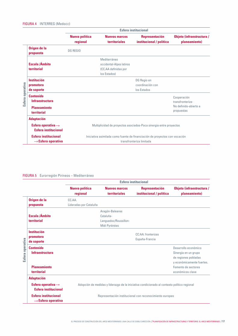
FIGURA 4 INTERREG (Medocc)
Esfera institucional
Nueva política Nuevos marcos Representación Objeto (infraestructura / regional territoriales institucional / política planeamiento)
Origen de la DG REGIO
propuesta
Mediterráneo Escala /Ámbito occidental-Alpes latinosterritorial (CC.AA defi nidas por los Estados)
Institución DG Regio en promotora coordinación con de soporte los Estados
Contenido Cooperación Infraestructura transfronteriza-
Planeamiento No defi nido-abierto a
territorial propuestas
Adaptación
Esfera operativa Multiplicidad de proyectos asociados-Poca sinergia entre proyectos Esfera institucional
Esfera institucional Iniciativa asimilada como fuente de fi nanciación de proyectos con vocación Esfera operativa transfronteriza limitada
Esfe
ra o
pera
tiva
FIGURA 5 Eurorregión Pirineos – Mediterráneo
Esfera institucional
Nueva política Nuevos marcos Representación Objeto (infraestructura / regional territoriales institucional / política planeamiento)
Origen de la CC.AA.propuesta Lideradas por Cataluña
Aragón-BalearesEscala /Ámbito Cataluña- territorial Languedoc/Roussillon- Midi Pyrénées
Institución CC:AA: fronterizas
promotora España-Francia
de soporte
Contenido Desarrollo económico Infraestructura Sinergia en un grupo de regiones pobladas y económicamente fuertes. Planeamiento Fomento de sectores territorial económicos clave
Adaptación
Esfera operativa Adopción de medidas y liderazgo de la iniciativa condicionado al contexto político regional Esfera institucional
Esfera institucional Representación institucional con reconocimiento europeo Esfera operativa
Esfe
ra o
pera
tiva

18 / Papers 44 / EL PROCESO DE CONSTRUCCIÓN DEL ARCO MEDITERRÁNEO: UNA CALLE DE DOBLE DIRECCIÓN
FIGURA 6 FERRMED
Esfera institucional
Nueva política Nuevos marcos Representación Objeto (infraestructura / regional territoriales institucional / política planeamiento)
Origen de la Sector empresarial
propuesta
Corredor Escala /Ámbito mediterráneoterritorial occidental-Ródano- Rin (difícil cohesión)
Institución Lobby empresarial sinpromotora representación de soporte territorial
Contenido Flujos económicos de Infraestructura mercancías
Corredor ferroviario de Planeamiento altas prestaciones territorial para mercancías
Adaptación
Esfera operativa Acuerdo y proyecto conjunto entre representantes del ámbito empresarial Esfera institucional (lobby empresarial europeo)
Esfera institucional Esfera operativa Difi cultad para coordinar una representación institucional conjunta
Esfe
ra o
pera
tiva
FIGURA 7 Red de ciudades C-6
Esferainstitucional
Nueva política Nuevos marcos Representación Objeto (infraestructura / regional territoriales institucional / política planeamiento)
Origen de la Área metropolitanapropuesta de Barcelona
Barcelona- Escala /Ámbito Montpellier-Palma- territorial Zaragoza-Toulouse- Valencia
Institución Ayuntamientos- promotora Entidadesde soporte metropolitanas
Contenido Desarrollo urbano Infraestructura
Planeamiento Planifi cación territorial estratégica
Adaptación
Esfera operativa Intercambio de experiencias y estrategias conjuntas de desarrollo urbano estratégico Esfera institucional
Esfera institucional Esfera operativa Desarrollo urbano policéntrico en contraposición a una política de cooperación autonómica
Esfe
ra o
pera
tiva

EL PROCESO DE CONSTRUCCIÓN DEL ARCO MEDITERRÁNEO: UNA CALLE DE DOBLE DIRECCIÓN / PLANIFICACIÓN DE INFRAESTRUCTURAS Y TERRITORIO. EL ARCO MEDITERRÁNEO / 19
FIGURA 8 Arco Latino
Esfera institucional
Nueva política Nuevos marcos Representación Objeto (infraestructura / regional territoriales institucional / política planeamiento)
Origen de la Associación de
propuesta administraciones
locales NUTS III
NUTS III entre AlgarveEscala /Ámbito
y Puglia (ámbitoterritorial
mediterráneo) + islas
Institución Lobby de Administraciones
promotora NUTS III. Ofi cina propia
de soporte
Contenido Desarrollo territorial Infraestructura Cooperación interterritorial Estrategia integrada Planeamiento Lobby frente a los territorial Estados y a Europa
Adaptación
Esfera operativa Lobby de administraciones locales en repuesta a políticas de alcance europeo Esfera institucional
Esfera institucional Representación de administraciones locales en interlocución Esfera operativa por programas de carácter europeo
Esfe
ra o
pera
tiva
FIGURA 9 EURAM
Esfera institucional
Nueva política Nuevos marcos Representación Objeto (infraestructura / regional territoriales institucional / política planeamiento)
Origen de la Sociedad civil propuesta Sector empresarial
Andorra-Aragón-Escala /Ámbito Baleares-Cataluña-territorial Languedoc/Roussillon- Comunidad Valenciana
Institución Institut Ignasi Villalonga
promotora d’Economia i Empresa
de soporte
Contenido Flujos económicos Infraestructura Necesidad de un corredor mediterráneo Planeamiento efi ciente en el transporte territorial de mercancías
Adaptación Esfera operativa Entendimiento parcial entre territorios (redes sectoriales) Esfera institucional
Esfera institucional Distanciamiento entre las escalas nacional y regional Esfera operativa Distanciamiento / acercamiento desiguales entre CC.AA
Esfe
ra o
pera
tiva
20 / Papers 44 / LAS INFRAESTRUCTURAS DE TRANSPORTE CONCEBIDAS COMO OBRAS TERRITORIALES
LAS INFRAESTRUCTURAS DE TRANSPORTE CONCEBIDAS COMO OBRAS TERRITORIALES.
Exigencias y estrategias de territorialización
SUMARIO
Introducción
1. Territorialidad transescalar de las infraestructuras de transporte
2. Del espacio-soporte al territorio
3. Más allá de los impactos y de los efectos territoriales de las infraestructuras de transporte3.1. Impactos y efectos 3.2. Tres simplifi caciones3.3. Redes y nudos: dos puntos de vista, dos estrategias, muchos confl ictos
4. Refl exionar nuevamente sobre la relación entre infraestructuras y territorio4.1. Perspectiva de la congruencia territorial4.2. Interconexión y territorialización de las intervenciones infraestructurales
5. Políticas para la interconexión y la territorialización de las infraestructuras: el reto de la multilevel governance
6. Conclusiones

LAS INFRAESTRUCTURAS DE TRANSPORTE CONCEBIDAS COMO OBRAS TERRITORIALES / PLANIFICACIÓN DE INFRAESTRUCTURAS Y TERRITORIO. EL ARCO MEDITERRÁNEO / 21
LAS INFRAESTRUCTURAS DE TRANSPORTE CONCEBIDAS COMO OBRAS TERRITORIALES.Exigencias y estrategias de territorialización1
FRANCESCA GOVERNA Departamento Interuniversitario Territorio
(Politécnico de Turín y Universidad de Turín)
Introducción
Las intervenciones infraestructurales generan en el te-rritorio modifi caciones invasivas y profundas, que deben ser planifi cadas, programadas y gestionadas. Sin embar-go, la necesidad de planifi car, programar y gestionar las transformaciones territoriales derivadas de las interven-ciones infraestructurales se enfrenta con notables difi -cultades, ya sean de orden teórico, ya de orden práctico. Estas difi cultades han de vincularse principalmente con la relación, difícil y con frecuencia confl ictiva, entre las lógicas sectoriales y los intereses supralocales, a los que responden las intervenciones infraestructurales, y las lógicas territoriales y los intereses locales de los lu-gares en donde van a tener lugar dichas intervenciones. Algunos casos recientes de la crónica, en particular la protesta del valle de Susa, en Italia, contra la línea de alta velocidad / alta capacidad ferroviaria que debería atrave-sar el valle para enlazar Turín con Lyon en el marco del Corredor V que une Kiev con Lisboa, nos hablan de las difi cultades de actuar para conseguir que se resuelvan estos confl ictos. Paralelamente, evidencian la urgencia de afrontarlos en el seno de un sistema de gobierno de las dinámicas territoriales cada vez más abierto y frag-mentado. Por consiguiente, el problema no radica tanto en el proyecto europeo o nacional de la alta velocidad ferroviaria o de los macrocorredores a escala continen-tal como en el signifi cado que asume la localización de estas intervenciones en determinados contextos regio-nales y locales (Albrechts y Coppens, 2003; Priemus y Zonneveld, 2003).
De cualquier forma, para perseguir este objetivo es im-prescindible refi nar las metodologías de análisis y de interpretación que permitan superar una visión de las infraestructuras de transporte como intervenciones de tipo puramente técnico o relativas a éste, a favor de una interpretación de las mismas como obras territoriales no sólo en relación con la escala geográfi ca que justifi ca su realización, sino también en función de la acción estruc-turante que la obra misma puede desarrollar a escalas jerárquicamente inferiores. Cambiar el modo de inter-pretar la infraestructura de transportes exige asimismo
una nueva visión de la relación entre las infraestructuras y el territorio con respecto a las interpretaciones más consolidadas, en las que la infraestructura se considera una intervención puramente técnica relacionada con el transporte, y los territorios son vistos como una panta-lla neutra en la que se proyectan estas intervenciones. Contrariamente, la intervención infraestructural puede ser interpretada como una posibilidad de transformación por parte de los diferentes niveles territoriales (Banister y Berechman, 2001).
Por lo demás, la hipótesis de concebir las intervenciones infraestructurales no como una necesidad con la que los territorios de nivel local o regional que las albergan de-ben convivir más o menos positivamente, minimizando los daños y maximizando las ventajas, sino como poten-cialidades para la recalifi cación y el desarrollo incluso a escala local y regional –aunque deba profundizarse en buena parte en sus implicaciones teóricas y prácticas–, empieza a abrirse paso en numerosos países europeos. No es ajeno a esta apertura el papel desempeñado por la política común de los transportes en el ámbito eu-ropeo, la cual ha introducido en el léxico de las políticas públicas nuevas palabras clave tales como integración, coordinación e interoperabilidad (EC, 2001). De igual ma-nera, el amplio debate internacional relativo al tema de la gobernanza (ESPON, 2006), en donde se subraya el cambio de las formas y de las modalidades de la acción colectiva en el ámbito urbano y territorial, identifi ca algu-nas direcciones de cambio también por lo que respecta a las políticas infraestructurales y de los transportes2. La superación del acercamiento tradicional a la planifi cación y a la consolidación, incluso en la práctica, de modelos de sociedad y formas de cooperación entre instituciones parece prefi gurar efectivamente el paso hacia procesos
1 Traducido del original italiano.2 Sobre las posibilidades y los límites de los modelos de governanza, entendidos
como modelos de políticas públicas en las que se enfatiza la coordinación horizontal y vertical de proyectos, actores y niveles territoriales en la gestión de las infraestructuras de red, véase Offner (2000). La situación del marco institucional relativo a la programación, al proyecto y a la gestión de las intervenciones infraestructurales en algunos países europeos se describe en Dematteis y Governa (2001).

22 / Papers 44 / LAS INFRAESTRUCTURAS DE TRANSPORTE CONCEBIDAS COMO OBRAS TERRITORIALES
negociados en los que, mediante la apertura de los foros de decisión, intervienen una pluralidad de sujetos perte-necientes a diferentes niveles de la jerarquía territorial (desde el más estrictamente local hasta la UE) y a una pluralidad de intereses.
Con este artículo, que se inserta en el seno de este de-bate, se pretende presentar y discutir una posible línea interpretativa a través de la cual pueda llevarse a cabo una reinterpretación de la relación entre infraestructuras y territorio que supere las lógicas, con frecuencia reduc-cionistas y deterministas, del estudio de los impactos y/o de los efectos territoriales de las realizaciones. La tesis central del artículo podría resumirse así: las infra-estructuras de transportes se interpretan normalmente como intervenciones de tipo puramente técnico y rela-cionadas con el transporte, defi nidas por una racionali-dad sectorial (el hecho de conectar). Sin embargo, este modo de ver las infraestructuras de transporte plantea numerosos problemas, de orden teórico y práctico. Para afrontarlos, es necesario cambiar de perspectiva, es de-cir, ver las infraestructuras como una posibilidad también a escala local y regional, una oportunidad para replantear las políticas sectoriales, en particular las relativas a las infraestructuras de transporte, como políticas integradas y destinadas a programar recorridos de desarrollo local. En otras palabras, las preguntas a las que intentaremos dar respuesta pueden resumirse de la siguiente forma: ¿Pueden convertirse las intervenciones infraestructura-les, aunque respondan a lógicas sectoriales e intereses supralocales, en posibilidades para los territorios de nivel local/regional en los que van a localizarse dichas inter-venciones? ¿Cómo podemos replantear la relación entre infraestructuras y territorio para superar una concepción de infraestructura como intervención puramente técni-ca y relacionada con el transporte, impuesta por el nivel supralocal al nivel local, al territorio, al medio ambiente, a los ciudadanos, a las estrategias de desarrollo de los lugares, y llegar a la territorialización de las infraestructu-ras? ¿Cómo debe actuarse para lograr que esto ocurra? Es decir, ¿qué tipo de políticas deben adoptarse? En los siguientes párrafos intentaremos dar una primera res-puesta a estas cuestiones.
1. Territorialidad transescalar de las infraestructuras de transporte
Empecemos, pues, por el modo de considerar las infra-estructuras y, en particular, por preguntarnos qué quiere decir considerar las infraestructuras de transporte como obras territoriales. El primer paso para aventurarnos por esta dirección consiste en abandonar una lógica de ca-rácter puramente funcional y relacionada con el trans-porte arraigada en la concepción de las infraestructuras de transporte e interpretar, por el contrario, los territo-rios que éstas atraviesan o sobre los que éstas insisten como una variable clave de las intervenciones infraes-tructurales. Se plantea, no obstante, otro interrogante.
¿Cuál es la escala, el nivel de territorio en que se defi ne el carácter territorial de la infraestructura? En efecto, la infraestructura es una obra territorial no sólo a la esca-la geográfi ca que justifi ca su realización, por lo general supralocal (por ejemplo, la Unión Europea para las TEN –Trans European Networks), sino también en el ámbito regional y más estrictamente local. De hecho, la obra infraestructural no sólo dota de infraestructuras el terri-torio a su nivel, sino que también instaura relaciones en los niveles territoriales inferiores: basta únicamente con pensar en los lugares “atravesados” por la red de alta velocidad/alta capacidad ferroviaria o en aquéllos en don-de se localizan los nudos de dicha red.
Este aspecto, aparentemente banal, ha sido descuida-do largo y tendido. En efecto, de acuerdo con la racio-nalidad jerárquico-funcional que describe las relaciones entre territorios a diferente escala (desde la Unión Eu-ropea al barrio), cada obra infraestructural tiene un nivel territorial propio, que es el que justifi ca la existencia y la conformación espacial en relación con su función te-rritorial predominante. De esta forma, por ejemplo, las redes de transporte transeuropeas pertenecen al nivel territorial de la UE, mientras se descuida la relación que estas redes instauran con el resto de niveles territoriales implicados en su realización.
Normalmente, por tanto, las obras infraestructurales se consideran obras territoriales en relación con el nivel al que se deciden, puesto que derivan de razones funcio-nales, geoeconómicas y geopolíticas que tienen sentido a estos niveles. En realidad, las intervenciones infraes-tructurales son, siempre y de cualquier forma, obras territoriales incluso en el ámbito local y regional. Sus trazados y sus nudos se presentan como oportunidades y amenazas para dichos niveles, esto es, para los territo-rios atravesados por las redes, para aquellos en que se están localizados los nudos o que acaban fagocitados en los campos de externalidad generados o modifi cados por las intervenciones infraestructurales. Por tanto, con-cebir las intervenciones infraestructurales como obras territoriales signifi ca verlas no sólo en relación con la es-cala geográfi ca que justifi ca su realización (por ejemplo, la red de trenes de alta velocidad como factor de co-hesión territorial a escala europea), sino también por la acción (directa e indirecta, querida y no querida, actual y potencial) que dichas obras pueden desarrollar a escalas jerárquicamente inferiores. Esto signifi ca que las obras infraestructurales ganan interés no sólo en sí mismas, ni en función de las razones técnicas y funcionales que las justifi can en su propio ámbito territorial, sino tam-bién en relación con el signifi cado que asume su loca-lización en los diversos contextos regionales y locales (Preston, 2001). Si consideramos las infraestructuras de transporte como obras territoriales, también debemos considerar así, en consecuencia, la multiplicidad de los territorios, de diferente nivel, a los que éstas hacen refe-rencia. El territorio de las infraestructuras es, por tanto, un territorio abierto y transescalar que, como subraya el

LAS INFRAESTRUCTURAS DE TRANSPORTE CONCEBIDAS COMO OBRAS TERRITORIALES / PLANIFICACIÓN DE INFRAESTRUCTURAS Y TERRITORIO. EL ARCO MEDITERRÁNEO / 23
geógrafo francés G. Di Méo (2000, pág. 41), «se refi ere a varias escalas del espacio geográfi co: desde el campo de la localidad al del Estado-nación o de las entidades supranacionales».
2. Del espacio-soporte al territorio
Si concebimos las infraestructuras de transporte como obras territoriales en la perspectiva transescalar deli-neada antes, resulta conveniente preguntarse cuál es la concepción de territorio más pertinente para entender la relación entre las infraestructuras y el territorio en térmi-nos no deterministas. En términos más explícitos, adop-tar una concepción compleja de infraestructura exige asimismo adoptar una concepción compleja de territorio. Por consiguiente, es necesario superar una concepción de territorio como simple soporte, pantalla neutra sobre la que se aplican exógenamente paquetes estandariza-dos de intervenciones, de tipo infraestructural y/o indus-trial, prescindiendo de los problemas y de las oportuni-dades específi cas de transformación, o como conjunto de recursos para explotar mediante intervenciones que, en lugar de valorizarlos, conducen a la destrucción de las especifi cidades de los lugares.
En el debate internacional, el reconocimiento de la cre-ciente importancia asumida por el nivel local-regional en diferentes ámbitos (económico, político-institucio-nal, cultural, etc.) ha desembocado en la afi rmación de una concepción compleja de territorio3. Con respecto a los estudios relativos a los niveles locales y regionales de los años setenta y ochenta del siglo XX, los actuales presentan algunas diferencias relevantes; en particu-lar, el reconocimiento de estos niveles como unidades territoriales en la competición global y la importancia alcanzada por las políticas relativas a la competitividad territorial (regional competition) (Cheshire y Gordon, 1996); la emergencia de las global city-regions; es decir, de sistemas locales-regionales capaces de pre-sentarse como nudos de la red global de la economía mundial (Scott, 1998), incluso desvinculados de la me-diación del nivel estatal (Le Galès, 2002); la concepción evolutiva de región, entendida como unidad histórica y geográfi camente específi ca (Allen et al. 1998; Paasi, 2002). En conjunto, este debate, incluso con énfasis di-ferentes, ha conducido al reconocimiento de la centrali-dad asumida por lo local y por los lugares en el seno de los procesos de la globalización, centrando la atención sobre el papel del territorio como actor de los procesos del desarrollo (Cox, 1997; Amin, 2002; Dematteis y Go-verna, 2005).
El territorio, por tanto, se ha convertido en una clave in-terpretativa central para entender los procesos de trans-formación y de desarrollo. Pero, ¿cómo ha sido concep-tualizado? Si hacemos referencia al debate italiano, las concepciones predominantes consideran el territorio como patrimonio territorial (Magnaghi, 2000) subrayan-do, en particular, los valores que caracterizan el territorio, y como capital territorial, que reconoce principalmente los recursos de los que está dotado un territorio, enten-didos, no obstante, como bienes comunes, que no pue-den caer en manos privadas, sino ser compartidos por una comunidad (Dematteis y Governa, 2005).
Las concepciones de patrimonio territorial y de capital territorial son en muchos sentidos similares, pero no coinciden perfectamente. Sin adentrarnos en el análisis de las semejanzas y diferencias, lo importante consiste en subrayar que éstas permiten interpretar el territorio como un conjunto multidimensional en donde se entre-tejen recursos y valores, el sentido del lugar, subjetivo y simbólico, y la concepción del lugar, relativamente obje-tiva y naturalista (Entrikin, 1991). Estas interpretaciones explicitan, pues, la naturaleza relacional del territorio; por consiguiente, para comprender el territorio es necesario apostarse en la encrucijada de dichas relaciones (Demat-teis, 1999). Esto nos obliga a abandonar la interpreta-ción de territorio como una realidad dada, rigurosamente reconocible y delimitable en los mapas, y a concebirlo como un ámbito dinámico y activo, una estructura so-cial que deriva de la interacción entre los sujetos y las características específi cas y fi jas (fi xed assets; cf. Amin, 2000), materiales e inmateriales, de los diferentes es-pacios.
En general, por consiguiente, a pesar de las diferencias entre las múltiples interpretaciones, se reconocen como ingredientes centrales de los procesos de transforma-ción y de desarrollo unas especifi cidades territoriales y unos actores locales. De esta forma, el territorio es el centro de las preocupaciones analíticas y operativas; es la referencia a partir de la cual se construyen y respecto a la que se deben evaluar las políticas y las acciones; en defi nitiva, es el elemento cardinal con respecto al cual emergen los confl ictos y las posibilidades de un poten-cial tratamiento.
3. Más allá de los impactos y de los efectos territoriales de las infraestructuras de transporte
La relación entre las infraestructuras y el territorio puede interpretarse de modos diversos; en primer lugar, en re-lación con la concepción de infraestructura (infraestruc-tura como obra pública, como obra pública en funciona-miento, como obra territorial, como red y/o como nudo) y de territorio que adoptemos. El cambio en el modo de interpretar tanto las infraestructuras de transporte como el territorio sobre el que se apoyan o en donde se locali zan las intervenciones exige asimismo un cambio
3 Baste pensar en el debate relativo al papel de las economías locales y regionales en los procesos del desarrollo (Storper, 1997; Crouch et al., 2001; Scott y Storper, 2003), en el debate inherente a la crisis de legitimidad y de eficacia de los niveles centrales de decisión en muchos países europeos, con la consiguiente puesta en marcha del llamado “renacimiento” regional (Keating, 1998; Le Galès y Lequesne, 1997) o, incluso, en el debate relativo a la redefinición de los niveles de la territorialidad inducida por los procesos de la globalización (Brenner, 1999).
24 / Papers 44 / LAS INFRAESTRUCTURAS DE TRANSPORTE CONCEBIDAS COMO OBRAS TERRITORIALES
en el modo de analizar la relación entre ambos términos. ¿Cómo podemos refl exionar, por tanto, sobre la relación entre infraestructuras y territorio si las infraestructuras se consideran obras territoriales y el territorio como un conjunto inextricable de recursos y valores? Para res-ponder a este interrogante, sin embargo, es necesario antes que nada superar una serie de lugares comunes relativos al modo habitual de considerar la relación entre infraestructuras y territorio.
3.1. Impactos y efectos
Por lo general, la relación con el territorio de las políticas de sector, en particular de las políticas de las infraes-tructuras de transporte, se trata en términos de efectos y/o de impactos (Governa, 2001)4. Más allá de la separa-ción entre impactos y efectos, aquéllos se subdividen en económicos, sociales, ambientales, energéticos, etc., y los efectos en acumulativos, distributivos, difundidos, o, incluso, en efectos directos e indirectos; a corto y a largo plazo; estructurantes y no estructurantes.
El estudio de los impactos y de los efectos territoriales de las infraestructuras de transporte se afi rma y se conso li da con la difusión de las redes técnicas modernas a fi nales del siglo XIX. A lo largo de los años, los impactos y los efectos han sido analizados de formas diferentes, lo cual ha dado origen a una evolución de los enfoques, los cua-les han redefi nido y complicado el objeto de estudio: de los efectos directos sobre las variables económicas a las consecuencias socioeconómicas-territoriales.
Hoy en día, los efectos originados en el territorio a raíz de la realización de nuevas intervenciones infraestructu-rales se conocen sufi cientemente y su estudio remite a un marco teórico-metodológico que puede considerarse consolidado. En realidad, la claridad y la precisión del marco teórico-metodológico de referencia remite sobre todo al análisis de los efectos directos, aunque no mo-difi ca una situación de incertidumbre general por lo que respec ta al carácter y la entidad de los efectos territoriales indirectos y de largo plazo (Banister y Berechman, 2001).
La evolución de las aproximaciones al estudio de los im-pactos y de los efectos territoriales de las intervencio-nes infraestructurales no ha modifi cado, sin embargo, el esquema teórico de referencia. Éste se refi ere principal-mente a un esquema de causalidad directa del tipo es-tímulo/respuesta. Las infraestructuras de transporte se consideran causa de las transformaciones esperadas, ya sean éstas un aumento de la riqueza, una modifi cación de los comportamientos de los individuos y de los esti-los de vida, ya sean transformaciones espaciales (Plas-
sard, 1997). Por consiguiente, la introducción de una nueva infraestructura de transporte es vista como causa de transformaciones territoriales, sociales y económicas reconocibles y evaluables a priori, mediante procedi-mientos de tipo exclusivamente técnico que relacionan un antes (abstracto) y un después (hipotético).
La interpretación de la relación infraestructuras/territorio como una relación de causa/efecto recibe críticas desde más de una vertiente. J. M. Offner (1993), por ejemplo, subraya la inconsistencia teórica y la inaplicabilidad prác-tica5. Esta crítica resalta, en particular, la imposibilidad de considerar la relación entre infraestructuras y terri-torio en términos de causalidad y de aislar la variable infraestructura de transporte del contexto y de las condi-ciones sociales, políticas y económicas que han permiti-do su realización. Para Offner (2000), asimismo, el papel desempeñado por una infraestructura en la evolución de un territorio debería ser estudiado no tanto comparando el antes y el después como el después real y el después virtual, incorporando de esta forma la contribución de otros procesos y cambios.
3.2. Tres simplifi caciones
El estudio de los impactos y/o de los efectos territoriales de las infraestructuras de transporte permite subrayar el papel que desempeña la intervención infraestructural en las dinámicas económicas y sociales, así como aclarar, por ejemplo, cuáles son las principales consecuencias que pueden derivarse de la realización de un determinado pro-yecto en un contexto particular. Sin embargo, éste se basa en algunas simplifi caciones y presenta algunos límites.
Una primera simplifi cación se refi ere al punto de vista adoptado. Tomar únicamente el punto de vista de las infraestructuras obliga a descuidar el punto de vista del territorio o, mejor dicho, a omitir la posibilidad de adoptar alternativamente ambos puntos de vista. Esto induce a considerar solamente los impactos/efectos de las infraestructuras sobre el territorio y no, al revés, las consecuencias que el territorio puede tener sobre las in-fraestructuras; no se tiene en cuenta que los modos de organización económica, social y política infl uyen más sobre las intervenciones infraestructurales de lo que es-tas últimas puedan hacerlo sobre los primeros (Joignaux, 1997). Además, considerar únicamente el punto de vista de las infraestructuras lleva a desatender el estudio de las estrategias empleadas por los actores implicados en el proceso relativo a la realización de las intervenciones, y de esta forma se desatiende uno de los aspectos cen-trales de la relación entre inversiones en infraestructuras de transporte y desarrollo económico en el ámbito local y regional (Banister y Berechman, 2001).
4 La diferencia entre impactos y efectos no es estricatamente terminológica. Según Offner (1993), los impactos son las consecuencias directas, negativas, causantes de la detonación y explosión de un equilibrio precedente; por el contrario, los efectos deben relacionarse con unas determinadas elecciones, ya que son las consecuencias, las recaídas colaterales, ya sean positivas o negativas, ya deseadas o indeseadas, de una acción, una política, una intervención.
5 La relación local /global no es, sin embargo, el único terreno de conflicto. Baste recordar la multiplicidad de intereses diversos y, en última instancia, conflictivos presentados por los actores locales involucrados, más o menos directamente, en la realización de las intervenciones, a raíz de lo que se abren posibles conflictos también en el marco local y entre los diferentes territorios implicados.
LAS INFRAESTRUCTURAS DE TRANSPORTE CONCEBIDAS COMO OBRAS TERRITORIALES / PLANIFICACIÓN DE INFRAESTRUCTURAS Y TERRITORIO. EL ARCO MEDITERRÁNEO / 25
La segunda simplifi cación atañe a la concepción de territorio que participa en el análisis y evaluación de las intervencio-nes. De hecho, el territorio se concibe simplemente como un soporte sobre el que se proyectan políticas y proyectos, se localizan funciones y actividades o, en última instancia, como el lugar en donde se experimenta, a posteriori, una difícil recomposición de los confl ictos. Esta visión limita la posibilidad de entender las interacciones que se establecen entre las intervenciones infraestructurales y el territorio, y se reduce a la lectura de las consecuencias, sean positivas o ne-gativas, de una intervención en un contexto que se presenta fi jo e inmutable, considerado, de una vez por todas, incapaz de interactuar con dinámicas externas al mismo, un contexto que, consiguientemente, sólo se modifi ca a partir de un pro-yecto intencional, infravalorando ampliamente los efectos no deseados, imprevistos e imprevisibles de cualquier acción humana y, en particular, de las políticas y de los proyectos que transforman el territorio (Crosta, 1995; 1998).
La tercera y última simplifi cación atañe a los argumentos empleados para analizar las intervenciones con el obje-tivo de legitimar la realización. De hecho, la realización de una infraestructura de transporte se considera una fuente de ventajas para el territorio en donde se loca-liza, capaz de garantizar su competitividad y desarrollo. Esta forma de plantear el problema tiende a ocultar, sin embargo, la compleja distribución de las ventajas y de las desventajas, así como los confl ictos de tipo social y territorial potenciales, derivados de la realización de cualquier intervención en el territorio y, en particular, de intervenciones importantes como las infraestructu-rales (Graham, 2000). Aunque las intervenciones infraes-tructurales funcionan positivamente porque aumentan las posibilidades de los sujetos y favorecen las dinámicas del desarrollo, no lo hacen de la misma forma para todos los sujetos, a todos los niveles y en todos los ámbitos territoriales implicados en el proceso.
3. 3. Redes y nudos: dos puntos de vista, dos estrategias, muchos confl ictos
La posibilidad de considerar las infraestructuras de trans-porte como obras territoriales choca con otras difi cul-tades, aparentemente conocidas y banales, pero con importantes consecuencias en la práctica.
La primera difi cultad hace referencia al empleo del con-cepto de red. Este concepto está muy arraigado en los estudios urbanos y territoriales, en donde se usa para indicar y describir cosas muy diferentes: el desarrollo de los asentamientos en determinados períodos, los modelos de localización de las actividades, las relacio-nes interurbanas y la defi nición de políticas cooperativas entre sistemas urbanos o, en fi n, los mecanismos de la acción colectiva que se defi nen en la acción de una mul-tiplicidad de actores de acuerdo con modelos de tipo, justamente, reticular (policy networks) (Lippi, 2001). Asimismo, en el análisis territorial, el término red puede adoptar signifi cados diferentes: uno literal y otro metafó-
rico. En sentido literal, las redes son esencialmente las «infraestructuras físicas continuas (líneas ferroviarias y viales, canales, electroductos, líneas telefónicas cablea-das, etc.) o puntuales (puertos, aeropuertos, telepuer-tos, emisores de radio y televisión y ondas hertzianas, etc.) que son la vía de fl ujos materiales (bienes, per-sonas) o inmateriales (informaciones) entre lugares» (Dematteis, 1996, pág. 229). Por lo que se refi ere a este tipo de redes técnicas, podemos localizar los recorridos y cuantifi car los fl ujos. En sentido metafórico, la red pierde gran parte de su materialidad y se convierte en una modalidad abstracta para representar relaciones y conexiones entre sujetos. En este caso, las redes «son estructuras de relaciones e interacciones estables entre sujetos (económicas, sociales, culturales, de servicios, de control, etc.) entendidas como relaciones entre los lugares (nudos) ocupados de forma estable por éstos (independientemente del trazado geográfi co de los fl u-jos que los enlazan)» (ibidem, págs. 229-230).
La superabundancia de usos y de signifi cados del concep-to de red tiene importantes consecuencias también por lo que se refi ere al asunto de las redes infraestructurales. De hecho, cuando se habla de la Europa de las redes, el empleo del término red es tanto de tipo literal como me-tafórico (Bobbio y Morisi, 2001). Desde el punto de vista literal, la expresión Europa de las redes indica que las in-fraestructuras, a escala continental, están organizadas de forma reticular (las infraestructuras de transporte, la pro-ducción y distribución de la energía, las telecomunicacio-nes, etc.). Desde el punto de vista metafórico, en cambio, la expresión indica que es posible describir el conjunto de las relaciones en la UE como una red y, más en particular, que la red no es sólo la característica de algunas infraes-tructuras europeas, sino también de los procesos a través de los cuales se formulan las políticas europeas. Tal como suponen Bobbio y Morisi (2001) parafraseando a Sraffa, en el marco de las infraestructuras podemos preguntar-nos si cabe la posibilidad de hablar de “gobierno de las redes mediante las redes”.
El segundo escollo hace referencia al asunto de los con-fl ictos. La realización de las intervenciones infraestruc-turales altera el statu quo y hace emerger las típicas formas del confl icto que derivan de la realización de las obras de interés colectivo: local frente a global; intereses difundidos frente a intereses concentrados; aspectos económicos frente a aspectos ambientales (Bobbio y Zeppetella, 1999)6. Los confl ictos derivados de las inter-venciones infraestructurales pueden explicarse conside-rando las “apuestas” de las políticas infraestructurales (Bobbio y Morisi, 2001): la fl uidez de las redes (es decir, cómo ha de producirse la comunicación, el transporte, el intercambio) y la morfología territorial (es decir, dónde
6 El efecto estructurante se considera un verdadero “mito operativo” que ”autoriza y legitima la acción de la persona que toma las decisiones; esto permite la elaboración de proyectos sectoriales, a pesar de la evidencia de las interrelaciones entre políticas públicas” (Offner, 1993, pág. 241).

26 / Papers 44 / LAS INFRAESTRUCTURAS DE TRANSPORTE CONCEBIDAS COMO OBRAS TERRITORIALES
deben producirse). Desde el punto de vista territorial, la segunda apuesta tiene consecuencias muy importan-tes en virtud del carácter espacialmente selectivo de las intervenciones infraestructurales, las cuales, necesaria-mente, privilegian algunos nudos y recorridos.
En cuanto a los actores y los marcos de decisión, las relaciones entre ambas apuestas son escasas, y sólo raramente se ven empujadas al confl icto. Desde el pun-to de vista de los actores implicados, el marco de las políticas europeas se activa sobre todo para la primera apuesta (cómo); el de los actores nacionales, regionales y locales, para la segunda (dónde).
La segunda apuesta presenta, a su vez, una importante diferencia: la forma territorial de la red asume un sig-nifi cado distinto si se concibe desde el punto de vista de los nudos o de los segmentos, de la misma ma-nera que son diferentes las estrategias que llevan a la práctica los lugares-nudo y los lugares-segmento. En efecto, todos los lugares anhelan alcanzar el estatus de nudo o incrementar su peso en la jerarquía de los nu-dos. Como es obvio, en éstos también se crean exter-nalidades nega tivas, como, por ejemplo, la congestión, pero en conjunto las ventajas superan a las desventajas. Respecto a una red infraestructural, los ámbitos territo-riales (de diferente nivel: nacional, regional, local) acaban compitiendo entre sí para obtener, consolidar o mejorar el estatus de nudo y, al mismo tiempo, se ven inducidos a establecer alianzas (a crear red) con otros ámbitos ter-ritoriales que podrían encontrarse en la misma directriz. Desde el punto de vista del nudo, en defi nitiva, el proble-ma consiste en atraer la red, conformarla o deformarla, respecto a sus propias exigencias.
En cuanto a los segmentos, la situación es radicalmente diferente. Ningún lugar ambiciona convertirse en un seg-mento: la condición del segmento es la de ser atravesa-do, algo que comporta muchos inconvenientes y ningu-na o poquísimas ventajas. Por consiguiente, los ámbitos territoriales intentan resistir el destino de convertirse en segmentos bloqueando u obstaculizando los fl ujos en la red, aumentando los costes y/o dilatando los tiempos de las intervenciones.
Por consiguiente, los nudos y los segmentos tienen in-tereses opuestos, de la misma forma que son opuestas las estrategias que éstos ponen en práctica: esquemá-ticamente, tenemos una estrategia de apertura de los lugares-nudo y una estrategia de cierre, con frecuencia considerada de forma reduccionista como localismo, de los lugares-segmento.
4. Refl exionar nuevamente sobre la relación entre infraestructuras y territorio
Si la infraestructura de transporte se defi ne como una obra territorial en la perspectiva transescalar delineada
antes y el territorio en donde ésta se localiza se consi-dera un operador activo a diferentes niveles, dotado de especifi cidad y racionalidad propias, refl exionar sobre la relación infraestructuras/territorio no signifi ca tanto llevar a cabo una evaluación más o menos atenta de los efec-tos y/o de los impactos, abandonando la causalidad de los esquemas interpretativos más consolidados, como descubrir las modalidades de interacción entre lógicas de red (tendencialmente sin contexto) y lógicas de nudo (locales y contextuales) (Dematteis, 1996).
4.1. Perspectiva de la congruencia territorial
Para llevar a cabo dicho cambio, Offner (1993) propone sustituir el concepto de efecto estructurante, sustancial-mente inadecuado para concebir la relación entre infra-estructuras y territorio en términos de interacciones no deterministas y no lineales, por el de congruencia territo-rial (congruence). Con este concepto el autor entiende el conjunto de cambios de una determinada organización económica y territorial que derivan de la unión entre dos sistemas, el de transporte y el socioterritorial, conside-rados ambos en toda su complejidad. De esta forma, el problema de la relación infraestructuras/territorio pue-de verse con una luz totalmente diferente respecto a las interpretaciones simplistas y al triple determinismo (tecnológico, económico y sociológico) que las apoya (Offner, 2000). En la perspectiva de la congruencia ter-ritorial, la relación entre infraestructuras y territorio deja de ser susceptible de descripción en términos de causa-lidad directa para ser considerada principalmente como un proceso de emparejamiento estructural en el que «las redes posibilitan la creación o el fortaleci miento de las interdependencias entre lugares, que pueden consi derarse pertenecientes a un territorio. En otras pa-labras, gracias a las redes los territorios componen un sistema» (Offner, 2000, pág. 170). Asimismo, éste deja de ser interpretado adoptando únicamente el punto de vista de la infraestructura y estudiando después, a pos-teriori, los impactos o los efectos sobre el territorio, sino que lo es a partir de los procesos, de las secuencias de acciones que se encuentran en el origen de la interven-ción in fraestructural y de su anclaje en el territorio. De esta forma, la relación entre infraestructura y territorio se estudia desde una óptica procesal que subraya tanto las relaciones, potencialmente confl ictivas, entre lógicas de red y lógicas de nudo como las interacciones que mantienen las intervenciones infraestructurales con la multiplicidad de los ámbitos territoriales, de diferente nivel, afectados por la intervención y dotados cada uno de ellos de una pluralidad de lógicas y de intereses.
4.2. Interconexión y territorialización de las intervenciones infraestructurales
Si se adopta la perspectiva de la congruencia territo-rial, la relación que las intervenciones infraestructurales mantienen con el territorio, ya sea ésta de tipo pura-mente técnico-organizativo, político-social o urbanístico-
LAS INFRAESTRUCTURAS DE TRANSPORTE CONCEBIDAS COMO OBRAS TERRITORIALES / PLANIFICACIÓN DE INFRAESTRUCTURAS Y TERRITORIO. EL ARCO MEDITERRÁNEO / 27
territorial, se presenta más compleja respecto al modo habitual de considerarla. Para intentar minimizar esta complejidad, y entender algo mejor en qué consiste la congruencia territorial de las infraestructuras de trans-porte, podemos descomponer la relación entre éstas y el territorio en dos procesos diferentes: uno en el que las infraestructuras de transporte establecen una re lación con las redes territoriales –es decir, el proceso de in-terconexión– y otro en el que las infraestructuras de transporte establecen una relación con los contextos ter ritoriales, o territorialización.
En un primer momento, el concepto de interconexión se ha empleado para describir el modo en que una nueva intervención infraestructural establece una relación –in-terconectándose o no– con el sistema infraestructural preexistente (Margail, 1995). A partir de esta concepción, que estudia la relación con lo existente desde un punto de vista sobre todo técnico-organizativo, el concepto de interconexión ha sufrido una profunda evolución. Se han multiplicado los enfoques relativos a este concepto y ha aumentado progresivamente la complejidad de los fenó-menos que éste permite describir. Fundamentalmente, se han introducido dos elementos de innovación: las multiplicaciones del tipo y del nivel de las redes que se interconectan y la atención al resultado que un proceso de estas características ha tenido sobre el territorio (Puc-ci, 1996). En esta reciente acepción, la interconexión no se entiende únicamente en un sentido técnico –es decir, como conexión intermodal o entre redes de transporte de diferente alcance territorial (por ejemplo, el tren de alta velocidad y los ferrocarriles regionales)–, sino tam-bién de conexión entre las redes técnicas y las redes inmateriales que actúan en un determinado nudo (por ejemplo, redes comerciales y de servicios, redes logís-ticas, redes de empresas, etc.). Éste abarca asimismo tanto la conexión horizontal entre redes pertenecientes al mismo nivel territorial como la vertical entre redes de diferentes niveles (local, supralocal y global). En defi niti-va, éste no da origen a la simple fusión o conexión de redes, sino sobre todo a una modifi cación global de los sistemas infraestructurales y territoriales que se inter-conectan (Governa, 2001). Entendido de esta forma, el proceso de interconexión describe la articulación espa-cial de una multiplicidad de redes, técnicas y territoria-les, una multiplicidad de sujetos, una multiplicidad de lógicas y principios organizativos.
Para defi nir el proceso de territorialización es útil refe-rirse a distintos modos de considerar la relación con los contextos territoriales. Una primera forma de entender la territorialización es la intuitiva: la territorialización es el proceso de localización de la intervención infraestructural en un territorio determinado y específi co. En este caso, la intervención infraestructural establece una relación con el territorio exclusivamente desde un punto de vis ta físico y se limita a la explotación de los factores de loca lización (por ejemplo, la presencia de áreas) presentes en el mis-mo. Una segunda forma de considerar la territorializa-
ción es aquella en que la intervención infraestructural se territorializa en un contexto local no simplemente situán-dola en su interior, sino vinculándose con los proyectos y con las intencionalidades expresadas por los sujetos lo-cales, estableciendo con los mismos sinergias e interac-ciones, reconociendo y valorando el capital territorial local incluso por lo que se refi ere a sus componentes in-materiales (conocimientos contextuales, capital social, capacidad institucional, etc.) (Governa, 2001; Dematteis y Governa, 2005). La intervención infraestructural, aun-que deriva de lógicas externas a cada contexto parti-cular, entra a formar parte de las lógicas territoriales, se arraiga en las especifi cidades del lugar, pone en marcha potencialidades territoriales específi cas, contribuye a la construcción de nuevas territorialidades (en parte en los mismos lugares y en los mismos territorios en donde se localiza, en parte no).
5. Políticas para la interconexión y la territorialización de las infraestructuras: el reto de la multilevel governance
El objetivo de los procesos de interconexión y de terri-torialización de las intervenciones infraestructurales con-siste en integrar las lógicas sectoriales de las interven-ciones infraestructurales, la de la planifi cación urbana y territorial y las del desarrollo local. Integración, así como coordinación e interoperabilidad, son las palabras clave de la política común relativa a los transportes en el ámbito europeo (EC, 2001). Sin embargo, cabe tener en cuenta que estas palabras han sido interpretadas de diferentes formas. En las políticas de transporte, el potencial de la integración puede ser entendido haciendo referencia a la integración entre entes, diferentes modos de transpor-te, distintas acciones, varias políticas (infraestructurales, de los transportes, de los usos del suelo, ambientales, educativas, para la salud, etc.) (Hull, 2005). Las múltiples dimensiones de la integración, y en particular las más complejas que, según A. Hull (2005), connotan los esca-lones más altos de la escala de la integración (que va del grado mínimo de la integración física y operativa de los transportes al grado máximo de la integración intersecto-rial entre políticas y medidas), no se alcanzan de manera espontánea y no pueden derivar de automatismos de mercado; exigen, sin embargo, acciones de gobernanza territorial que permitan entrelazar las estrategias adopta-das por los diferentes actores (ESPON, 2006).
Por consiguiente, la interconexión y la territorialización de las intervenciones infraestructurales no se llevan a cabo espontáneamente; ambas se verifi can al menos por dos motivos. El primer motivo está relacionado con la naturaleza de las intervenciones infraestructurales: para realizar las infraestructuras de transporte, no debe actuarse de forma aumentativa, a partir de pruebas y erro-res; se imponen, en cambio, elecciones de carácter terri-torial de consecuencias irreversibles. El segundo motivo atañe al hecho de que las intervenciones infraestructura-

28 / Papers 44 / LAS INFRAESTRUCTURAS DE TRANSPORTE CONCEBIDAS COMO OBRAS TERRITORIALES
les no se limitan a evaluar situaciones territoriales dadas, como, por ejemplo, la presencia de un sistema produc-tivo local o de recursos territoriales e inmobiliarios, sino que pueden activar procesos acumulativos de desarrollo (Dematteis, 2001).
La convergencia de las lógicas sectoriales, caracterís-ticas de las infraestructuras, con la lógica territorial de los contextos locales es un problema presente en todas las escalas; por tanto, no sólo existe en el ámbito local, sino también por lo que respecta al apoyo institucional y a la dirección organizativa de los entes territoriales in-termedios y la coordinación del gobierno estatal. Con el objetivo de que las intervenciones infraestructura-les, aun respondiendo a lógicas sectoriales e intereses supralocales, puedan interconectarse y territorializarse convirtiéndose en recursos para el desarrollo y la recali-fi cación a escala local, es necesario construir sinergias e interacciones con los proyectos y los recursos activos y activables a estas escalas, en el seno de un proceso en el que interviene una multiplicidad de sujetos e in-tereses7. Así pues, para favorecer la interconexión y la territorialización de las intervenciones es imprescindi-ble una política de infraestructuras de transporte que responda a las lógicas de la multilevel governance. En el seno de esta lógica, se modifi ca el papel del sujeto público que, aun teniendo la misión de desempeñar un papel de pilotage, de direction o de acompañamiento de las interacciones entre los sujetos, más que de regu-lación y control directo de las transformaciones, sigue siendo fundamental.
Frente al proyecto de una intervención infraestructural, el sujeto público muestra una gama variada de reacciones, que derivan obviamente del modo en que dicha interven-
ción ha sido pensada, programada y gestionada (fi g. 1). Estos comportamientos van de una actitud totalmente negativa y defensiva a una actitud creativa y activa. En el primer caso, el proyecto infraestructural se considera un input externo con efectos deterministas sobre el con-texto local en donde se aplica. El papel del sujeto público es, en este caso, el de prever y gestionar dichos efectos, intentando minimizar los negativos, conseguir eventua-les compensaciones monetarias y redistribuir los efec-tos positivos, en un juego equilibrado, sin pérdidas ni ganancias. Por el contrario, la actitud creativa y activa rechaza una visión del territorio como máquina banal y lo considera un sistema complejo, capaz de autoorgani-zarse y, por ello, capaz de interactuar con los sujetos su-pralocales promotores o mediadores de la intervención infraestructural. Esta última se considera un estímulo y una ocasión para evaluar la especifi cidad del territorio, mediante la movilización de los recursos de proyecto y autoorganizativos característicos de los sujetos locales y la puesta en práctica de visiones estratégicas y accio-nes de integración interna (construcción de la red local de los sujetos para la territorialización de la intervención) y de integración externa (negociación de las condiciones de interconexión con los promotores supralocales)8. 6. Conclusiones
Para fi nalizar, puede ser de utilidad intentar resumir las lecciones derivadas del cambio de perspectiva en la for-ma de considerar y, por tanto, de programar, proyectar y gestionar, las obras de infraestructuras. De hecho, hemos delineado diferentes modos de describir e in-terpretar la relación entre infraestructuras y territorio, cuyas diferencias dependen, en primer lugar, de la dis-tinta forma de defi nir los dos conceptos claves. Si se adoptan diversas concepciones de infraestructura y de territorio, será posible entender la diversidad de proce-sos y de resultados que se defi nen en esta relación. La concepción de infraestructura como obra territorial, y de la multiplicidad de ámbitos territoriales en que ésta se inserta como entidades dinámicas y activas, describe la relación entre infraestructuras y territorio en términos interactivos: un proceso de interconexión y territorializa-ción de las intervenciones cuyo resultado puede confi -gurar un juego con ganancia.
Este modo de considerar el problema modifi ca la interpre-tación habitual de las infraestructuras de transporte y de su relación con el territorio, así como los procedimientos usuales de análisis y valoración de las intervenciones. Si dejamos de considerar las intervenciones infraestructura-les como obras sectoriales, derivadas de una racionalidad técnica y relativa a los transportes, para concebirlas como
FIGURA 1 Papel del sujeto público en las intervenciones infraestructurales
Fuente: Dematteis (2001), modifi cado.
7 Por lo demás, el Esquema de desarrollo del espacio europeo (CEC, 1999) también dedica a este problema uno de los capítulos iniciales y destaca la importancia de la oportuna coordinación de las políticas sectoriales de connotación territorial a diferentes escalas.
8 Entre las principales dimensiones de una acción de gobernanza territorial, Le Galès (1998) reconoce el cambio de papel de la acción pública, la integración interna, la integración externa y la orientación hacia la estrategia, todas ellas dimensiones fundamentales para llevar a cabo la territorialización de las intervenciones infraestructurales.
LAS INFRAESTRUCTURAS DE TRANSPORTE CONCEBIDAS COMO OBRAS TERRITORIALES / PLANIFICACIÓN DE INFRAESTRUCTURAS Y TERRITORIO. EL ARCO MEDITERRÁNEO / 29
obras territoriales dentro de una perspectiva transescalar, debemos aprender a considerar los caracteres técnico-funcionales de las infraestructuras no como invariables, sino como datos que deben hacerse interactuar con las racionalidades y los proyectos específi cos de los contex-tos. De hecho, considerarlos invariables lleva a plantear el problema de la relación con el territorio sólo a posteriori y, por tanto, a tratarlo en términos de mitigación de los impactos. Asimismo, si adoptamos esta interpretación, la racionalidad de sector no puede imponerse a los con-textos locales (aunque sólo sea por razones de efi ciencia y de velocidad de los procesos de toma de decisiones, en la realidad totalmente desatendidas), pero las carac-terísticas específi cas de los lugares y las racionalidades presentes en su seno sí deben ser incorporadas entre las variables iniciales de los proyectos. La implicación y el acuerdo sobre las elecciones estratégicas de los actores involucrados exigen encontrar formas y procedimientos claramente defi nidos y actuar en las fases iniciales del proceso de toma de decisiones. Esta forma de ver y tratar la relación con el territorio de las infraestructuras de trans-porte modifi ca asimismo las modalidades de evaluación de las intervenciones infraestructurales. Ésta no debe entenderse como un cierre del proceso de toma de deci-siones, como palabra fi nal que permite validar o falsifi car
elecciones ya efectuadas, como una herramienta de mi-tigación a posteriori de los impactos de una obra ya deci-dida con antelación, sino como un momento del proce so de defi nición y de realización de las intervenciones. De esta manera, el esquema estimativo ya no se construye como un procedimiento de conformidad respecto a pará-metros defi nidos de antemano, sino que se confi gura como un procedimiento relativo a las prestaciones, que, tal como escribe A. Zeppetella (1999), «renuncia (…) a defi nir reglas de toma de decisiones generales y abstrac-tas y sitúa en el centro del razonamiento el contexto con-creto y sus especifi cidades» (pág. 158).
Como es obvio, estas sugerencias no son defi nitivas; todavía son muchos los problemas abiertos, sobre todo si el objetivo consiste en responder a las necesidades prácticas de cómo programar y proyectar infraestructu-ras de transporte interconectadas y territorializadas, en el seno de una relación constructiva con las caracterís-ticas, las especifi cidades y los actores de los contextos en que van a introducirse. Por consiguiente, la necesi-dad de confrontarse con las prácticas es cada vez más prioritaria para responder a preguntas muy urgentes y desvelar los aspectos operativos de la relación entre in-fraestructuras y territorio.
Bibliografía
Albrechts, L., y T. Coppens (2003); “Megacorridors: striking a balance between the space of fl ows and the space of places”, Journal of Transport Geography, 11, págs. 215-224.
Allen, J.; A. Cochrane y D. Massey (1998); Rethinking the re-gion, Routledge, Londres.
Amin, A. (2000); “The economic base of contemporary city”, en G. Bridge y S. Waston (eds.), A companion to the city, Black-well, Oxford, págs. 115-129.
Amin, A. (2002); “Spatialities of globalisation”, Environment and planning A, 34, págs. 385-399.
Banister, D., e Y. Berechman (2001); “Transport investment and the promotion of economic growth”, Journal of Transport Geo-graphy, 9, págs. 209-218.
Bobbio, L., y A. Zeppetella, eds. (1999); Perché proprio qui? Grandi opere e opposizioni locali, Angeli, Milán.
Bobbio, L., y M. Morisi (2001); “Reti infraestructurales, reti decisionali e rappresentanza nell’Unione Europea”, Teoria Politica, XVII, 1, págs. 65-86.
Brenner, N. (1999); “Globalisation as Reterritorialisation: The Re-scaling of Urban Governance in the European Union”, Urban Studies, 36, 3, págs. 431-451.
CEC. Comisión de las Comunidades Europeas (1999); ESDP.European Spatial Development Perspective. Towards Balanced and Sustainable Development of the Territory of the EU, aproba-do por los ministros responsables del Regional/Spatial Planning of the European Union, Luxemburgo.
Chesire, P. C., e I. R. Gordon, eds. (1996); Territorial competition in an integrating Europe, Avebury, Aldershot.
Cox, K. R., ed. (1997); Spaces of globalization. Reasserting the power of the local, The Guilford Press, Londres.
Crosta, P. L. (1995), La politica del piano, Angeli, Milán.
Crosta, P. L. (1998); Politiche. Quale conoscenza per l’azione te-rritoriale?, Angeli, Milán.
Crouch C.; P. Le Galès; C. Trigilia y H. Voelzkow, eds. (2001); Local Production Systems in Europe. Rise or demise?, Oxford University Press, Oxford.
Dematteis, G. (1996); “Grandi opere e contesti territoriali locali”, en A. Clementi (ed.), Infrastrutture e piani urbanistici, Fratelli Pa-lombi Editori, Roma, págs. 229-245.
Dematteis, G. (1999); “Sul crocevia della territorialità urbana”, en G. Dematteis; F. Indovina; A. Magnaghi; E. Piroddi; E. Scandurra y B. Secchi, I futuri della città. Tesi a confronto, Angeli, Milán, págs. 117-128.
Dematteis, G. (2001); “Introduzione. Tema, articolazione e risul-tati della ricerca”, en G. Dematteis y F. Governa (eds.), op. cit., págs. 7-19.
Dematteis, G., y F. Governa, eds. (2001); Contesti locali e grandi infraestructuras. Politiche e progetti in Italia e in Europa, Angeli, Milán.
Dematteis, G., y F. Governa (2005); “Il territorio nello sviluppo locale. Il contributo del modello SLoT”, en G. Dematteis y F. Go-verna (eds.), Territorialità, sviluppo locale, sostenibilità: il mode-llo SLoT, Angeli, Milán, págs. 15-38.

30 / Papers 44 / LAS INFRAESTRUCTURAS DE TRANSPORTE CONCEBIDAS COMO OBRAS TERRITORIALES
Di Méo, G. (2000); ”Que voulons-nous dire quand nous par-lons d’éspace?”, en J. Lévy y M. Lussault (eds.), Logique de l’éspace, esprit des lieux, Belin, París, 37-48.
EC. –Comisión Europea (2001); European transport policy for 2020: Time to decide, Ofi cina de Publicaciones Ofi ciales de las Comunidades Europeas, Luxemburgo.
Entrikin, J. N. (1991); The betweenness of place. Towards a Geography of Modernity, Macmillan, Londres.
ESPON. European Spatial Planning Observation Network (2006); Governance of Territorial and Urban Policies form EU to Local Level (2004-2006), tercer informe provisional, ESPON Project 2.3.2. (http://www.espon.lu/).
Governa, F. (2001); “Ripensare il rapporto infraestructuras/ter-ritorio. Il valore aggiunto territoriale delle infraestructuras di transporte”, en G. Dematteis y F. Governa (eds.), op. cit., págs. 23-44.
Graham, S. (2000); “Introduction: Cities and Infrastructure Net-works”, International Journal of Urban and Regional Research, 24, 1, págs. 114-119.
Hull, A. (2005); “Integrated Transport Planning in the UK: from con-cept to reality”, Journal of Transport Geography, 13, págs. 318-328.
Joignaux, G. (1997); “L’approche des relations entre infra-structure et territoires: retours sur la théorie et les méthodes”, en A. Burmeister y G. Joignaux (eds.), Infrastructures de trans-port et territoires. Approches de quelques grands projets, L’Harmattan, París, págs. 19-38.
Keating, M. (1998), The new regionalism in Western Europe, Elgar, Cheltenham.
Le Galès, P. (1998); “La nuova political economy delle città e delle regioni”, Stato e Mercato, 52, págs. 53-91.
Le Galès, P. (2002); European cities, Oxford University Press, Oxford.
Le Galès, P., y C. Lequesne, eds. (1997); Les paradoxes des régions en Europe, La Découverte, París.
Lippi, A. (2001); “La ‘rete’ come metafora e come unità di anali-si del policy making”, Teoria Politica, XVII, 1, págs. 87-114.
Magnaghi, A., (2000); Il progetto locale, Bollati Boringhieri, Turín.
Margail, F. (1995); “Connessione, interconnessione, interfaccia: elementi semantici”, Archivio di Studi Urbani e Regionali, 53, págs. 7-21.
Offner, J. M. (1993); “Les effets structurants du transport: mythe politique, mystifi cation scientifi que”, L’espace géographi-que, 3, págs. 233-242.
Offner, J. M. (2000); “Territorial Deregulation: Local Authorities at Risk from Technical Networks”, International Journal of Urban and Regional Research, 24, 1, págs. 165-182.
Paasi, A. (2002); “Place and Region: regional worlds and words”, Progress in Human Geography, 26, 6, págs. 802-811.
Plassard, F. (1997); “Les effets des infrastructures de transport. Modèles et paradygmes”, en A. Burmeister y G. Joignaux (eds.), Infrastructures de transport et territoires. Approches de quel-ques grands projets, L’Harmattan, París, págs. 41-54.
Preston, J. (2001); “Integrating transport with socio-economic activity: a research agenda for the new millennium”, Journal of Transport Geography, 9, págs. 13-24.
Priemus, H., y W. Zonneveld (2003); “What are corridors and what are the issues? Introduction to special issue: the gover-nance of corridors”, Journal of Transport Geography, 11, págs. 167-177.
Pucci, P. (1996); I nodi infraestructurales: luoghi e non luoghi metropolitani, Angeli, Milán.
Scott, A. J. (1998); Regions and the world economy: the com-ing shape of global production, competition and political order, Oxford University Press, Oxford.
Scott, A. y M. Storper (2003); “Regions, globalization, develop-ment”, Regional Studies, 37, 6-7, págs. 579-593.
Storper, M. (1997); The Regional World. Territorial Development in a Global Economy, The Guilford Press, Nueva York y Lon-dres.
Zeppetella, A. (1999); “Le valutazioni ambientali tra routine am-ministrativa e dialogo negoziale”, en L. Bobbio y A. Zeppetella (eds.), op. cit., págs. 131-184.

32 / Papers 44 / PLANIFICACIÓN DE INFRAESTRUCTURAS Y PLANIFICACIÓN TERRITORIAL
PLANIFICACIÓN DE INFRAESTRUCTURAS Y PLANIFICACIÓN TERRITORIAL.
Gobernanza y gestión de dinámicas multiescalares
SUMARIO
1. Infraestructuras, elemento básico permanente de las políticas de fomento y desarrollo regional a cualquier escala
2. Reinterpretando las relaciones entre ordenación del territorio y planifi cación de infraestructuras: apuntes desde el enfoque de la gobernanza territorial
3. Gestión de dinámicas multiescalares para la cohesión en una UE ampliada: infraestructuras transeuropeas para nuevas áreas y ejes de desarrollo
4. Arco Mediterráneo occidental, crónica para un desbloqueo
Bibliografía

PLANIFICACIÓN DE INFRAESTRUCTURAS Y PLANIFICACIÓN TERRITORIAL / PLANIFICACIÓN DE INFRAESTRUCTURAS Y TERRITORIO. EL ARCO MEDITERRÁNEO / 33
PLANIFICACIÓN DE INFRAESTRUCTURAS Y PLANIFICACIÓN TERRITORIAL. Gobernanza y gestión de dinámicas multiescalares
JOAQUÍN FARINÓS DASÍDepartamento de Geografía e
Instituto Interuniversitario de Desarrollo Local (Universidad de Valencia)
1. Infraestructuras, elemento básico permanente de las políticas de fomento y desarrollo regional a cualquier escala
Por infraestructuras entendemos la parte del capital glo-bal de una economía que, al presentar características de bien público, no es suministrada por el mercado o lo es de forma inefi ciente, motivo por el que su provisión ha estado liderada por el sector público. Resulta un factor clave para y en el desarrollo territorial sostenible, motivo por el que debe tener tratamiento de bien público y par-ticipado por la ciudadanía.
Existen muy diversos tipos de infraestructuras. De acuer-do con la clasifi cación en árbol planteada por Gil, Pascual y Rapún (1998; págs. 462-463) hay dos grandes tipos de infraestructuras: las naturales (derivadas del medio físico, como un río, un valle, etc.) y las derivadas de la ac-tuación antrópica. De entre las segundas cabe distinguir entre la infraestructura institucional y la física. La infraes-tructura física se divide a su vez entre la social (educati-va, sanitaria, centros asistenciales y culturales, edifi cios y equipamientos utilizados por la Administración) y la económica, también denominada infraestructura básica. Ésta se compone de los servicios públicos (distribución de agua, electricidad y gas natural, recogida de basuras y depuración de residuos), los servicios de telecomunica-ciones (telefonía, correo, cable, etc.), la gestión del suelo (mejora de drenajes, prevención de inundaciones y otros riesgos naturales o tecnológicos) y, fi nalmente, las infra-estructuras de transporte (carreteras, ferrocarriles, vías fl uviales, puertos y aeropuertos). El presente texto se centra en las últimas.
No hace falta insistir demasiado en la idea de que las in-fraestructuras de transporte siguen siendo consideradas elemento estratégico de primer orden para el objetivo del desarrollo y la cohesión territorial, a escala europea o regional. Condición necesaria pero no sufi ciente, han sido elemento clave de la política regional surgida de la reforma de los fondos estructurales de 1988, del docu-mento de la Estrategia Territorial Europea –como segun-da de sus tres directrices fundamentales1– y del objetivo
de la integración territorial en una Unión Europea (UE) ampliada, tratando de hacer compatible el crecimiento y la cohesión. Las infraestructuras no generan desarro-llo por sí solas, pero su carencia (su inexistencia o su cantidad y calidad inadecuadas) puede impedir el efi caz aprovechamiento del potencial de cada territorio (Biehl y Muenzer, 1986).
La atención prestada a las infraestructuras, o mejor a la movilidad y a la accesibilidad en el territorio de la UE, no sólo no ha dejado de tener actualidad, sino que éstas siguen siendo consideradas elemento de primer orden, hasta el punto de constituir una prioridad para el Banco Europeo de Inversiones y para la Comisión, pero tam-bién para el conjunto de los Estados miembros2. Tam-bién el documento Principios directores para el desarro-llo territorial sostenible del continente europeo (CEMAT, 2000; pág. 16) señala en su recomendación (35) que una política de ordenación territorial más equilibrada debe asegurar una mejor interconexión de las ciudades pe-queñas y medianas así como de los espacios rurales y de las regiones insulares con los principales ejes y cen-tros de transporte (vías férreas, autopistas, puertos, ae-ropuertos, centros intermodales) y la eliminación de las carencias en materia de enlaces intrarregionales3.
Sin duda, la actual consideración de las infraestructuras presenta nuevas componentes, como es la atención prestada a la sostenibilidad, asociada ahora a la intermo-dalidad, como forma de aliviar la congestión del tráfi co rodado, y de paso el consumo de energías fósiles y los niveles de emisión de gases contaminantes a la atmós-fera en la línea del protocolo de Kioto; de reducir los costes y aumentar la calidad de vida en los espacios en forma de malla (incentivando el uso del ferrocarril como medio de transporte para viajeros y mercancías); e in-cluso de promover alternativas de desarrollo para áreas costeras en declive mediante la recuperación del papel de los puertos4. La importancia que los Estados siguen otorgando a las infraestructuras de transporte quedaban recogidas en un reciente informe fi nal del proyecto ESPON 2.4.2

34 / Papers 44 / PLANIFICACIÓN DE INFRAESTRUCTURAS Y PLANIFICACIÓN TERRITORIAL
Integrated analysis of transnational and national territo-ries based on ESPON results. En un intento de aproxi-marse a las relaciones existentes entre las políticas terri-toriales desarrolladas a escala estatal y comunitaria, se preguntaba a los expertos nacionales participantes en el proyecto, pero también a los representantes de los pro-pios Estados en el Comité de Seguimiento (Monitoring Committee –MC–) del programa ESPON –generalmente técnicos de la Administración o próximos a ella–, cuá-les eran las prioridades políticas, actuales y futuras, de cada Estado para el objetivo del desarrollo territorial. El resultado se muestra claramente en las fi guras 1 y 2. Es la cuestión de la accesibilidad y el transporte, con gran diferencia, la que ocupa y preocupa a los Estados para el objetivo del desarrollo territorial, mucho más que otros elementos del sistema territorial como los asentamien-tos, la planifi cación de los usos del suelo o las cuestio-nes medioambientales.
2. Reinterpretando las relaciones entre ordenación del territorio y planifi cación de infraestructuras: apuntes desde el enfoque de la gobernanza territorial
Como ya señalábamos en una anterior publicación para re-ferirnos al ámbito europeo (Farinós, 2004), en línea con lo apuntado por Tarroja (2000), se está produciendo un giro territorial de las políticas sectoriales, que quieren avanzar hacia el objetivo de un desarrollo territorial sostenible, hacia una mayor sostenibilidad ambiental, una mayor co-hesión social y un desarrollo socioeconómico endógeno. Precisamente el objetivo de la planifi cación territorial es asegurar y mejorar el funcionamiento socioeconómico y socioecológico de los territorios teniendo en cuenta los principios del desarrollo sostenible. La planifi cación terri-
torial se encuentra vinculada con un amplio abanico de políticas locales, regionales, nacionales y comunitarias, entre ellas especialmente las de desarrollo regional, ur-banismo y vivienda, así como de infraestructuras.
Redes e infraestructuras de transporte tienen una in-fl uencia cada vez más relevante tanto para las estruc-turas y los modelos territoriales como para las visiones de futuro, en tanto que impiden o promueven transfor-maciones radicales en la organización territorial poten-ciando dinámicas o contribuyendo a contrarrestar los desequilibrios territoriales (fi gs. 3 y 4).
Aunque la cooperación horizontal entre políticas no se refi ere únicamente al sector de las infraestructuras, lo cierto es que su impacto sobre la organización territorial es de primerísimo orden, hasta el punto de que en el caso español, en el que de acuerdo con la STC 61/1997 el Gobierno central no tiene competencias para diseñar ni desarrollar un plan español de ordenación del territo-rio, el Plan Nacional de Infraestructuras viene a ocupar su lugar. De esta forma se supedita la ordenación terri-torial a la planifi cación de infraestructuras, a su vez poco conectada con la planifi cación económica regional salvo en las regiones objetivo 1, para las que es preceptiva la preparación de su Plan de Desarrollo Regional en cada comunidad autónoma; por cierto, sin tomar en conside-ración otro tipo de redes de infraestruturas distintas de las intrarregionales. Es ésta una situación bastante aleja-da de lo que debe reclamarse para el buen gobierno del territorio o, dicho de otro modo, para la gobernanza del desarrollo territorial sostenible.
En uno de los encuentros técnicos celebrados a lo lar-go del proceso de elaboración del Plan Estratégico de
FIGURA 2 Futuras prioridades de las políticas nacionales de desarrollo territorial
*Nota: las traducciones de los conceptos se encuentran al fi nal del artículo.Fuente: Proyecto ESPON 2.4.2, Informe Final, pág. 317.
FIGURA 1 Prioridades actuales de las políticas nacionales de desarrollo territorial
*Nota: las traducciones de los conceptos se encuentran al fi nal del artículo.Fuente: Proyecto ESPON 2.4.2, Informe Final, pág. 317.

PLANIFICACIÓN DE INFRAESTRUCTURAS Y PLANIFICACIÓN TERRITORIAL / PLANIFICACIÓN DE INFRAESTRUCTURAS Y TERRITORIO. EL ARCO MEDITERRÁNEO / 35
FIGURA 3 Elementos con infl uencia sobre las tendencias territoriales actuales
*Nota: las traducciones de los conceptos se encuentran al fi nal del artículo.Fuente: Proyecto ESPON 2.4.2, Informe Final, págs. 305-306.
Infraestructuras de Transporte (Ministerio de Fomento, 2005), concretamente en el apartado titulado “Infraes-tructuras, territorio y paisaje”, Benabent (2005) abordaba las relaciones entre la planifi cación de infraestructuras y la ordenación del territorio. Apoyándose en un preciso análisis de las distintas normativas relacionadas con los transportes (ley 16/1987, de 30 de julio de Ordenación de los Transportes Terrestres, ley 25/1988 de 29 de ju-lio de Carreteras, ley 27/1992, de 24 de noviembre, de Puertos del Estado y de la Marina Mercante) refería la prevalencia del interés y las competencias sectoriales sobre las horizontales territoriales5. La ordenación del territorio pretende, tras el pertinente análisis territorial, defi nir un modelo territorial cuyo resultado, en opinión del autor, ”… es la suma de una propuesta de distribu-ción de los usos del suelo… y de determinación de las infraestructuras que van a propiciar el funcionamiento del conjunto”. Y continúa: ”… Si no existe conjunción de las políticas sectoriales con la OT [organización territo-rial] el resultado es que el impacto de las infraestructu-ras territoriales lleva al fracaso de la política territorial” (Benabent, 2005; pág. 12); y viceversa, cabría añadir.
No son pocas las voces –en un momento en el que va cobrando vigor la idea de la necesidad de una planifi -cación territorial estratégica, a pesar de la reticencia de quienes siguen considerando el plan como instrumento supremo sufi ciente– que hacen la misma interpretación pero invirtiendo los términos. La pregunta entonces es si se puede diseñar un plan de infraestructuras de trans-porte sin haber defi nido previamente la planifi cación territorial. Si se diera primacía al objetivo de la coheren-cia, la respuesta resulta obvia. Pero si se atiende, como sucede, a razones más pragmáticas (peso de grandes grupos de presión con importantes intereses económi-
cos; abandono hasta hoy por el legislador estatal de la pretensión de dotar al sistema de un régimen general de las relaciones interadministrativas y reproducción de este modelo en las comunidades autónomas, salvo muy contadas excepciones, además con una concepción distinta de la ordenación del territorio en cada caso), el orden de la secuencia, tal como hoy en día aparece defi -nido, resulta fácil de explicar. A ello cabe añadir el hecho de que la presencia de las políticas sectoriales resulta imprescindible; eso sí, con una visión que respete los principios generales de actuación, lo que aquí se ha lla-mado coherencia de las actuaciones. Se considera la planifi cación territorial como la mejor vía para conseguir ese objetivo de coherencia de las actua-ciones, entendida la planifi cación del desarrollo territorial sostenible tal como lo hace la CEMAT en cuanto expre-sión geográfi ca de las políticas económicas, sociales, ecológicas y culturales de la sociedad. Al mismo tiempo, es una disciplina científi ca, una técnica administrativa y política de desarrollo en la que el acercamiento interdis-ciplinario y comprehensivo dirige hacia un desarrollo re-gional equilibrado y orienta a una organización física del espacio según una estrategia total.
La planifi cación del desarrollo territorial presenta natura-leza integral o comprehensiva y requiere la articulación de las distintas políticas sectoriales con impacto territo-rial. Esta planifi cación precisa tanto de relaciones inter-institucionales verticales (multinivel) como horizontales (multisectoriales, entre territorios y entre actores). Es aquí donde el desarrollo de nuevas prácticas de gober-nanza territorial pueden resultar especialmente útiles, con el objetivo de mejorar no sólo la coherencia, sino la efectividad de las actuaciones; en suma, para mejorar
FIGURA 4 Elementos con infl uencia sobre las tendencias territoriales futuras
*Nota: las traducciones de los conceptos se encuentran al fi nal del artículo.Fuente: Proyecto ESPON 2.4.2, Informe Final, págs. 305-306.
36 / Papers 44 / PLANIFICACIÓN DE INFRAESTRUCTURAS Y PLANIFICACIÓN TERRITORIAL
los rendimientos de las políticas e inversiones públicas. Los párrafos siguientes que cierran este segundo apar-tado se dedican a reinterpretar las relaciones entre la OT y las infraestructuras de transportes desde la óptica de la planifi cación territorial estratégica, dejando para el siguiente tercer apartado las implicaciones de una nueva gobernanza territorial.
La cuestión clave en las nuevas relaciones entre la planifi ca ción de infraestructuras y la planifi cación terri-torial con un enfoque estratégico reside en saber si la plani fi cación de infraestructuras de transporte, físicas, por defi nición una planifi cación de tipo duro, puede ser efectuada con un enfoque estratégico, más blando, o no; si en el caso de las infraestructuras es posible la pla-nifi cación fl exible, aceptando que pueda serlo en otros campos. Esto nos acerca a la discusión sobre la nece-sidad y pertinencia del plan o, en palabras de Indovina (2004; pág. 6), del tránsito del plan a la planifi cación, en-tendida esta última como el elemento de coordinación del plan con el resto de las políticas.
La efi cacia de los planes no depende estrictamente del fi el cumplimiento de la norma y del programa de actua-ciones, sino de la posibilidad de ajustarlos a las condicio-nes cambiantes del entorno durante su realización en función de los resultados de la evaluación continua. Planifi car, como dice Indovina, signifi ca construir el fu-turo, y eso no resulta fácil en una situación en la que los cambios ocurren de forma acelerada. Si el plan debe ser fl exible para adaptarse a los cambios, pierde su vo-cación de construir el futuro; pero en caso de no hacerlo se incurre en la contradicción técnica y política de dejar los problemas del presente para el futuro. Es éste un confl icto de difícil solución. En otros campos distintos de la planifi cación de infraestructuras de transporte se dice que hoy en día planifi car es gobernar las transfor-maciones desde la óptica del interés general y con una visión de futuro, en lugar de producirlas. Pero ¿es esto posible en su caso, dado el carácter de bien público que éstas presentan?
La planifi cación de transportes es de una fl exibilidad limitada, con largos plazos de ejecución (se trata de actuaciones prolongadas para las que se requieren in-versiones muy elevadas), secuencial en el tiempo (no todas pueden construirse a la vez) y selectiva sobre el territorio (en toda decisión sobre trazados y tiempos de ejecución siempre hay ganadores y perdedores), y con unos efectos muy duraderos en el tiempo. Si, por tanto, responde más a la fi losofía del plan que de la planifi ca-ción antes enunciada, entonces habría que incardinar el plan de infraestructuras con la planifi cación territorial6, y en el proceso de elaboración del plan, incrementar la participación (conciliar las distintas visiones u opciones) con el objeto de asegurar la mejor opción7.
Esta misma carencia de fl exibilidad hace todavía más necesaria en el caso de las infraestructuras la evaluación
ex-ante y conceder una importancia capital a las redes secundarias que conectan con las vías principales na-cionales y transeuropeas, lo que nos lleva a la dimen-sión vertical, multinivel, de la gobernanza territorial. En estas redes secundarias el rediseño es más fácil y la autosufi ciencia mayor; por tanto, también su nivel de fl exibilidad8.
3. Gestión de dinámicas multiescalares para la cohesión en una UE ampliada: infraestructuras transeuropeas para nuevas áreas y ejes de desarrollo
En el nuevo marco del territorio-red, entendido como conjunto de la estructura espacial formada por nodos y canales (materiales y no) de circulación de fl ujos, cada territorio, cada espacio local, cada ciudad, debe diseñar su propia estrategia para constituirse en un anclaje de las nuevas redes. No hay red sin infraestructuras, sin corredores de transporte y telecomunicaciones, pero tampoco sin relaciones entre actores. Así pues, las in-fraestructuras y la gobernanza (nuevo gobierno del terri-torio) aparecen interconectados en el nuevo contexto de la globalización.
Ya se ha hecho referencia a la importancia capital de las redes de transportes para las estructuras territoriales, im-pidiendo o promoviendo transformaciones radicales en la organización territorial, al potenciar dinámicas existentes o contrarrestar desequilibrios territoriales para contribuir a alcanzar de este modo el objetivo de la cohesión te-rritorial. También se ha citado su carácter secuencial (no todas pueden ser construidas al mismo tiempo), sus lar-gos plazos de ejecución y que requieren importantes in-versiones. Pero una vez defi nidas y ejecutadas, también presentan riesgos, tanto desde el punto de vista de la sostenibilidad (incrementando el tráfi co, los niveles de emisión de gases contaminantes y los costes, provocan-do un encarecimiento del transporte) como de la efectivi-dad (por ejemplo, el llamado efecto túnel).
En el primer caso, la intermodalidad se plantea como el método más adecuado para lograr un modelo territorial equilibrado, policéntrico y sostenible. La combinación de los modos es diferente según el objetivo. Esto es especialmente importante en el caso del transporte de cargas. Pero, de acuerdo con el objetivo de la accesibi-lidad y la reducción del carácter periférico, ¿qué tipo de infraestructuras resultan más efectivas… o más estra-tégicas? A este respecto, los resultados de los informes realizados son bastante explícitos. Desde una dimen-sión continental europea, los efectos más importantes para la Península Ibérica los tiene el transporte aéreo. En segundo lugar, aunque con mucho menor impacto, el ferrocarril, mientras que la carretera se muestra muy poco relevante en esta escala (MOPTMA, 1996).
La misma conclusión se obtiene de la observación de la cartografía presentada por Hervé et al. (2003; págs.

PLANIFICACIÓN DE INFRAESTRUCTURAS Y PLANIFICACIÓN TERRITORIAL / PLANIFICACIÓN DE INFRAESTRUCTURAS Y TERRITORIO. EL ARCO MEDITERRÁNEO / 37
103, 105, 107 y 110). Por tanto, desde un punto de vis-ta estratégico, de accesibilidad a escala continental, la intermodalidad más efi ciente es la del avión-ferrocarril. Lógicamente tiene sus limitaciones, al corresponderse fundamentalmente con el transporte de viajeros y, en menor medida, para mercancías de escaso volumen y alto valor por unidad de producto. Para cargas, como es sabido, el medio más utilizado es la carretera, aunque el ferrocarril, y su conexión con los puertos, puede recu-perar protagonismo atendiendo a las recomendaciones que la Comunidad ha realizado en documentos como la ETE o el Libro Blanco de los Transportes (CE, 2002).
En suma, la intermodalidad más efi ciente en el caso del transporte de pasajeros es la que combina avión y ferrocarril, mientras que para el caso de mercancías es la de puertos y ferrocarril. El tráfi co rodado es sin duda más efi ciente desde el punto de vista de la cobertura territorial. Para el transporte (intermodal) de cargas, el espacio regional suele considerarse de forma conjunta con el obje to de ofrecer los servicios necesarios que garanticen el sufi ciente nivel de tráfi co (umbral de mer-cado)9. Para el transporte de viajeros, en cambio, los más re levantes son los espacios urbanos y suburbanos (Hervé et al., 2003; pág. 49). La nueva estructura territo-rial que se derivará de la implantación de nuevos modos y nuevas conexiones intermodales abre un campo de importantes posibilidades en el que cada espacio local deberá tratar de situarse. No parece exagerado afi rmar que el momento actual resulta comparable, desde el punto de vista de los efectos sobre el modelo territorial, al que en su día supusieron para el conjunto español la división provincial y, más recientemente, el Estado de las autonomías.
En el segundo caso, el de la efectividad, la solución pasa por una mayor integración de las infraestructuras en el territorio, lo cual nos traslada al concepto de desarrollo local territorial (véase el artículo de Francesca Governa en este mismo volumen), caracterizado por la coordina-ción de las políticas territoriales y de infraestructuras, la cooperación entre territorios y sus agentes. Estos territo-rios y actores comparten necesidades y estrategias co-munes mediante la cooperación territorial, la formación de asociaciones y la implicación de los agentes locales y regionales, incluidos los poderes públicos, en el diseño, la evaluación y la fi nanciación de las infraestructuras10. Esta cooperación territorial y ciudadana, acordando por ejemplo itinerarios, paradas, puntos de ruptura o nodos potenciales, contribuye a anclar la infl uencia de las infra-estructuras en los territorios que atraviesan, amortiguan-do la excesiva polarización y las discontinuidades entre puntos bien comunicados, en tanto que se promueve una integración de los distintos niveles de las redes, de la local a la supranacional, combinándolas para compartir ganancia.
Como señala el proyecto ESPON 1.2.1 (Hervé, B. et al., 2003), las redes transeuropeas de transporte son ante
todo unas redes interregionales. Esto nos lleva, de nue-vo, a recordar la necesidad de que los territorios lleguen a establecer redes de colaboración territorial, tanto hori-zontal como vertical (CE, 1999; pág. 39). Para el territorio comunitario Davoudi (2003a) tipifi ca como cooperación vertical la que se establece entre la Unión Europea, los Estados miembros, las regiones y los poderes locales; mientras que la horizontal se produce entre ciudades, regiones o Estados vecinos. Ambas cooperaciones de-ben considerarse simultáneamente, con una perspectiva integrada, porque independientemente de su titularidad, toda infraestructura forma parte de la red, lo cual a su vez plantea la necesidad de la cooperación interadministrati-va (la ya referida gobernanza multinivel). Así es reconoci-do por parte de los propios estados europeos, tal como muestra la fi gura 5. Las visiones compartidas tienen la doble ventaja de encontrar menos barreras de entrada, lo cual incrementará su efectividad, y ser más duraderas o, al menos, menos vulnerables a los cambios de ciclo polí-tico, lo que redundará no sólo en una mayor efi cacia, sino también en la efi ciencia de las inversiones. Debe tenerse en cuenta además que, en materia de redes transeuro-peas de transporte, el papel que pueden desempeñar los propios territorios (Estados y regiones) es el más impor-tante desde el punto de vista fi nanciero.
Así pues, la cooperación territorial se constituye como elemento clave para la cohesión territorial11. El Tercer In-forme de la Cohesión (CE, 2004), así como también las posteriores Directrices estratégicas comunitarias para la cohesión 2007-2013 (CE, 2005) prevén la cooperación territorial como una de las prioridades para la política de cohesión. Esta cooperación se ajusta de forma explícita
FIGURA 5 Asuntos en los que la coordinación entre los niveles comunitario y estatal se considera más necesaria
*Nota: las traducciones de los conceptos se encuentran al fi nal del artículo.Fuente: ESPON Project 2.4.2, Final Report, pág. 321.

38 / Papers 44 / PLANIFICACIÓN DE INFRAESTRUCTURAS Y PLANIFICACIÓN TERRITORIAL
al objetivo del desarrollo territorial a escala europea, a través de la idea de petites Europes (fi g. 6) y en un hori-zonte a largo plazo. La cooperación territorial ha llegado a convertirse en uno de los tres objetivos de la futura po-lítica de cohesión para el próximo período de programa-ción, junto con los de convergencia (tradicional objetivo 1) y de competitividad (objetivo 2)12.
A la luz de los objetivos de Lisboa, el reto clave para reforzar la cohesión territorial es incrementar el capital territorial de todas las regiones de la UE y promover la integración entre ellas; es decir, promover sinergias trans-europeas y conjuntos (clusters) de actividades compe-titivas e innovadoras. La agrupación de regiones con un adecuado nivel de infraestructuras contribuirá a propor-cionar la masa crítica necesaria para competir en una economía global.
En términos prácticos, la cohesión territorial implica, en-tre otras cosas, una mejor posición de las regiones de Europa reforzando su perfi l y facilitando su conectividad e integración territorial mediante la cooperación transeu-ropea. En realidad, lo que quiere decirse desde los do-cumentos europeos es que debe reforzarse la perspec-tiva de la UE en las estrategias nacionales y regionales, teniendo en cuenta la identidad, la especialización y la posición territoriales. Dicho de otro modo, cada territorio debe identifi car su desarrollo potencial único y su posi-ción en el territorio europeo, y situar las estrategias de desarrollo territorial en un contexto de desarrollo trans-nacional y europeo. Para ello, y pensando en losobjetivos de la Agenda de Lisboa y Gotemburgo, debiera asegurarse una implicación activa de las autoridades de
planifi cación nacional y regional. Para ello se pretende potenciar un ”… mayor uso de la cooperación transna-cional para la planifi cación y toma de decisiones a es-cala regional y nacional, así como para los programas estructurales; y una mayor base jurídica para la coopera-ción transnacional y transfronteriza combinada con una gestión de la UE más apropiada” (Consejo Europeo de Rotterdam, 2004; págs. 16, 19)13.
4. Arco Mediterráneo occidental, crónica para un desbloqueo
Cuando se llega a la aplicación de una estrategia mediante la cual una amplia serie de ciudades periféricas de Europa pretenden incrementar sus posibilidades de competir en un mercado global a través de la integración policéntrica de sus pueblos y ciudades vecinas, el reto más difícil es de sarrollar vínculos económicos, la especialización funcional, porque sin ellos una región urbana policéntrica quedará reducida a mera imagen simbólica y no será un espacio funcional integrado (Davoudi 2003b). Para ello, las infraestructuras constituyen un elemento fundamental.
Como señala la autora, hay dos áreas clave en las que la intervención política es particularmente útil: el desarrollo de infraestructuras físicas (redes efi caces de transporte y de telecomunicaciones) y de infraestructuras blandas, en especial la capacidad normativa (infraestructuras ins-titucionales) y la identidad regional. Precisamente éste es el doble reto que tiene planteado el espacio medite-rráneo occidental europeo (conocido también como Arco Latino), especialmente en la parte española del Arco Me-diterráneo y su conjunción con la parte francesa. Aunque la cooperación es más fácil entre los territorios dinámi-cos capaces de encontrar más intereses en común, las opciones territoriales de los políticos pueden caminar en otro sentido. Así por ejemplo, y desde una perspectiva exclusivamente española, pese a las evidentes diferen-cias desde el punto de vista policéntrico y del sistema de ciudades, demográfi co y económico, entre los ejes Murcia-Valencia-Girona y Alicante/Valencia-Madrid, y de que la cooperación es más fácil entre territorios dinámi-cos capaces de encontrar más intereses en común, la prioridad de un modelo radial ha prevalecido desde muy antaño. Sin embargo, en el nuevo contexto de los terri-torios en red no existen motivos, sino más bien todo lo contrario, para las estrategias territoriales monopólicas, que signifi quen excluir otras alternativas presentes o cualesquiera otras posibles que se demuestren con po-tencialidades para el conjunto de territorios implicados.
Puede decirse por tanto, que el Arco Mediterráneo occi-dental no ha sido una prioridad real de los diferentes pla-nes a escala de los Estados, y tampoco en consecuencia para la UE14. De hecho, pese a que aparece claramente refl ejado en los mapas del policentrismo15 y se reconoce como una de las nuevas megalópolis del siglo XXI (Boi-ra, 2006 –citando a Richard Florida–), lo cierto es que el
FIGURA 6 Petites Europes en una Europa policéntrica
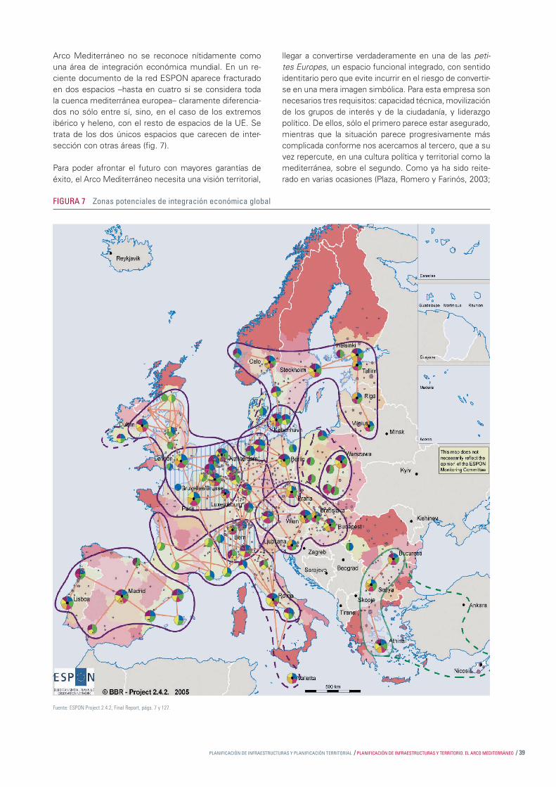
PLANIFICACIÓN DE INFRAESTRUCTURAS Y PLANIFICACIÓN TERRITORIAL / PLANIFICACIÓN DE INFRAESTRUCTURAS Y TERRITORIO. EL ARCO MEDITERRÁNEO / 39
Arco Mediterráneo no se reconoce nítidamente como una área de integración económica mundial. En un re-ciente documento de la red ESPON aparece fracturado en dos espacios –hasta en cuatro si se considera toda la cuenca mediterránea europea– claramente diferencia-dos no sólo entre sí, sino, en el caso de los extremos ibérico y heleno, con el resto de espacios de la UE. Se trata de los dos únicos espacios que carecen de inter-sección con otras áreas (fi g. 7).
Para poder afrontar el futuro con mayores garantías de éxito, el Arco Mediterráneo necesita una visión territorial,
llegar a convertirse verdaderamente en una de las peti-tes Europes, un espacio funcional integrado, con sentido identitario pero que evite incurrir en el riesgo de convertir-se en una mera imagen simbólica. Para esta empresa son necesarios tres requisitos: capacidad técnica, movilización de los grupos de interés y de la ciudadanía, y liderazgo político. De ellos, sólo el primero parece estar asegurado, mientras que la situación parece progresivamente más complicada conforme nos acercamos al tercero, que a su vez repercute, en una cultura política y territorial como la mediterránea, sobre el segundo. Como ya ha sido reite-rado en varias ocasiones (Plaza, Romero y Farinós, 2003;
FIGURA 7 Zonas potenciales de integración económica global
Fuente: ESPON Project 2.4.2, Final Report, págs. 7 y 127.

40 / Papers 44 / PLANIFICACIÓN DE INFRAESTRUCTURAS Y PLANIFICACIÓN TERRITORIAL
Farinós y Payá, 2006), la implicación y el liderazgo, o me-jor el compromiso, de los diferentes niveles político-admi-nistrativos, especialmente de los subestatales, resultan imprescindibles. Deben ensayarse nuevas formas de co-operación territorial a todas las escalas (regional, estatal, transfronteriza), sin exclusividad (es posible llegar a esta-blecer acuerdos múltiples de asociación), pero con una clara defi nición de objetivos y de las prioridades compar-tidas. El marco que ha supuesto INTERREG IIIB, o mejor la fi losofía que lo impregna, debería ser la base sobre la
que seguir profundizando en el ensayo de nuevas formas compartidas de información territorial e intercambio de experiencias que conduzcan fi nalmente a una estrategia territorial de conjunto construida sobre las de cada uno de los territorios que lo integran (Farinós, 2006). Sólo así, con la introducción y puesta en práctica de nuevas formas de gobernanza territorial, o si se prefi ere de las nuevas prác-ticas de la gobernanza en la planifi cación territorial y de infraestructuras, se nos antoja viable, en el medio plazo, desbloquear la situación actual.
Bibliografía
Benabent, M. (2005); ”La ordenación del territorio y su relación con la planifi cación de infraestructuras y servicios de transpor-te”, Encuentro técnico Infraestructuras, territorio y paisaje, Ce-dex, Madrid, 18 págs.
Biehl, D. y U. A. Muenzer (1986); Resume du rapport: ‘L’Impact de l’infrastructure sur le développement régional’. Étude relati-ve a l’Espagne et Portugal, Ofi cina de Publicaciones Ofi ciales de las Comunidades Europeas, Luxemburgo.
Boira, J. V. (2006); ”Mapas para el siglo XXI”, Levante, 17 de julio, pág. 3.
CE (Comisión Europea) (1999); ETE. Estrategia Territorial Europea. Hacia un desarrollo equilibrado y sostenible de la UE, Ofi cina de Pu-blicaciones Ofi ciales de las Comunidades Europeas, Luxemburgo.
CE (Comisión Europea) (2002); Libro Blanco. La política europea de transportes de cara al 2010: la hora de la verdad, Ofi cina de Pu-blicaciones Ofi ciales de las Comunidades Europeas, Luxemburgo.
CE (Comisión Europea) (2004); Una nueva asociación para la cohesión. Convergencia, competitividad, cooperación. Tercer in-forme sobre la cohesión económica y social. Ofi cina de Publica-ciones Ofi ciales de las Comunidades Europeas, Luxemburgo.
CE (Comisión Europea) (2005); Non paper on the Strategic Community Guidelines fo Cohesión 2007-2013, CE, 27 de abril de 2005, 23 págs. (más anexo de mapas).
CE (Comisión Europea) (2006a); Por una Europa en movimiento. Movilidad sostenible para nuestro continente. Revisión interme-dia del Libro Blanco del transporte de la Comisión Europea de 2001. Comunicación de la Comisión al Consejo y al Parlamento Europeo, COM (2006) 314 fi nal, Bruselas, 22 de junio de 2006.
CE (Comisión Europea) (2006b); Posición común aprobada por el Consejo con vistas a la adopción del Reglamento del Par-lamento Europeo y del Consejo relativo a la creación de una agrupación europea de cooperación territorial (AECT), Comuni-cación de la Comisión al Parlamento Europeo, de conformidad con el artículo 251, apartado 2, párrafo 2º, del Tratado CE, COM (2006) 308 fi nal, Bruselas, 13 de junio de 2006.
CEMAT (2000); Principios directores para el desarrollo territo-rial sostenible del continente europeo, documento preparado por el Comité de Altos Funcionarios, Conferencia Europea de Ministros responsables de Ordenación del Territorio, Hannover, 7-8 de septiembre,
CEMAT (2003); Implementation of strategies and visions for sustainable spatial development of the European continent, de-claración de Liubliana, 16-17 de septiembre,
Consejo europeo de ministros de ordenación del territorio (2004); Explotar la diversidad territorial europea para el creci-miento económico sostenible, documento de discusión para la reunión informal de ministros de la UE sobre cohesión territo-rial, Rotterdam, 29 de noviembre de 2004, 20 págs.
Davoudi, S. (2003a); ”Planifi cación territorial: la experiencia in-glesa”, en J. Romero y J. Farinós (eds.), Ordenación del territo-rio y desarrollo territorial. El gobierno del territorio en Europa: tradiciones, contextos, culturas y nuevas visiones, TREA, Gijón, págs. 173-190.
Davoudi, S. (2003b); ”Polycentricity in European Spatial Plan-ning: From an Analytical Tool to a Normative Agenda”, European Planning Studies, 11(8), págs. 979-999.
Farinós, J. (2004); ”La Ordenación del Territorio en Europa y su repercusión en el Arco Mediterráneo”, en Diputación de Valencia (ed.), La ordenación del territorio en las administraciones públi-cas, Diputación de Valencia, Valencia, págs. 29-56.
Farinós, J. (2005); ”La cohesión territorial: en busca de una mixtura entre competitividad, modelo social europeo, soste-nibilidad y nuevas formas de gobernanza”, en J. Mora Aliseda y F. Dos Reis Condesso (coords.), Políticas urbanas y territoriales en la Península Ibérica, 2 vols., vol. 1, págs. 63-80.
Farinós, J. (2006); Infl uencia potencial / Perspectivas de infl uencia de los procesos de gobernanza sobre el desarrollo espacial en el sur de Europa, conferencia pronunciada en el Seminario Transna-cional Punto Focal ESPON (ECP), Dimensiones críticas para una gestión territorial sostenible en el sur de Europa: tendencias, situa-ción y perspectivas de futuro, organizado por el Observatorio de la Sostenibilidad en España, Alcalá de Henares, 11-12 de mayo.
Farinós, J., y M. Payá (2004); ”El papel de la cooperación inter-regional y transfronteriza como instrumento de equilibrio terri-torial”, comunicación presentada en la XXX Reunión de Estudios Regionales, La política regional en la encrucijada, Barcelona, 18-19 de noviembre, 25 págs.
Farinós, J., y M. Payá (2005); ”Cooperación territorial transfronte-riza y cohesión territorial. España y Portugal ante la futura política regional europea”, comunicación presentada en el X Coloquio Ibé-rico de Geografía, La geografía ibérica en el contexto europeo (eje temático A: ”Nuevas estrategias y reorganización territorial en una Europa ampliada”), Évora, del 22 al 24 de septiembre, 20 págs.
Farinós, J., y M. Payá (2006); ”La experiencia de las comarcas centrales valencianas”, en J. Romero y J. Farinós (eds.), Gober-nanza territorial en España. Claroscuros de un proceso a partir del estudio de casos, Publicacions de la Universitat de València/Instituto Interuniversitario de Desarrollo Local, Colección Desa-rrollo Territorial nº 1, Valencia, págs. 193-218.

PLANIFICACIÓN DE INFRAESTRUCTURAS Y PLANIFICACIÓN TERRITORIAL / PLANIFICACIÓN DE INFRAESTRUCTURAS Y TERRITORIO. EL ARCO MEDITERRÁNEO / 41
* Conceptos implicados en las evaluaciones de prioridades e influencias
Accessibility-transport Accesibilidad-transporteAgricultural development Desarrollo agrícolaCultural heritage Patrimonio culturalDemography DemografíaEnvironment Medio ambienteGeographical handicaps Desventajas geográficasHRD Desarrollo de los recursos humanosICT infrastructure Infraestructura de comunicacionesInnovation Innovación Land use Usos del sueloLabour market Mercado de trabajoLisbon performance Estrategia de LisboaNatural hazards Desastres naturalesNatural heritage Patrimonio naturalPolycentric development Desarrollo policéntricoR & D I + DRural development Desarrollo ruralSettlement structure Estructura de poblamientoTechnical hazards Desastres técnicosUrban-rural relations Relaciones urbano-ruralesUnemployment Desempleo
1 Acceso equivalente a las infraestructuras y el conocimiento, a través del ”… Fo-mento de estrategias integradas de transporte y comunicación que sirvan de ayuda para el desarrollo policéntrico del territorio comunitario, constituyendo una condición necesaria para la participación activa de las ciudades y regiones europeas en la UEM. Deberán conseguirse paulatinamente unas condiciones equitativas de acceso a las infraestructuras y al conocimiento, para lo que será necesario encontrar soluciones adaptadas a las diferentes regiones” (CE, 1999; pág. 21).
2 En 2005 la DG Regio editaba, como número 18 de la publicación Inforegio panorama, un monográfico titulado ”Transport, a driving force for regional development”, 27 págs. El 22 de junio de 2006 se adoptaba la comunicación Europa en marcha: una política de transportes para la movilidad sostenible (CE, 2006a), revisión a medio plazo del Libro Blanco sobre el transporte de 2001, que incluye las nuevas directrices de la futura política de transporte. Las acciones previstas en el citado Libro Blanco, como potenciar las conexiones ferroviarias y marítimas en el transporte de mercancías a larga distancia, se complementarán con otras nuevas (la incorporación de nuevas tecnologías, de nuevos sistemas inteligentes que mejoren la eficacia, una mayor interoperabilidad de los equipamientos, fomento del consumo de los combustibles verdes, revisión del modelo de movilidad en las ciudades, etc.) para ayudar a reducir las negativas consecuencias de la dependencia energética y la calidad del medio ambiente. Y todo ello sin olvidar que la movilidad es motor de la prosperidad y la libertad de movimientos de los ciudadanos europeos y las mercancías en un espacio común. Puede concluirse por tanto que los transportes no han dejado de ser parte importante de la agenda política de la UE, como también lo han venido siendo de la política regional y de los fondos estructurales, especialmente en las regiones objetivo 1. Hay que recordar que el Fondo de Cohesión Territorial
está reservado exclusivamente a las redes de transporte y a las infraestructuras medioambientales.
3 Textualmente dice: ”(35) Para el logro de un desarrollo regional más equilibrado es necesario mejorar las conexiones de las ciudades pequeñas y medias, de los espacios rurales y de las regiones insulares con los principales ejes y centros de transporte (ferrocarriles, autovías, puertos, aeropuertos, o centros intermodales). La accesibilidad regional puede también mejorarse resolviendo las conexiones interregionales que faltan. Dado el aumento continuo del volumen de tráfico, son necesarias estrategias integradas que tengan en cuenta, simultáneamente, las características de los diferentes modos de transporte y los requisitos de ordenación territorial. En este sentido debe tenerse en cuenta el menor impacto medioambiental del ferrocarril, las vías fluviales y el transporte marítimo…”.
4 La consideración intermodal de los medios de transporte, especialmente en el transporte de mercancías, puede contribuir mejor al objetivo de un modelo territorial equilibrado, policéntrico y sostenible.
5 Resulta de gran interés el repaso que hace, citando las aportaciones de ilustres juristas interesados por el territorio como Luciano Parejo y Pérez Andrés, de las importantes limitaciones para el desarrollo de las relaciones horizontales y verticales de cooperación y coordinación entre políticas, y entre los tres niveles del Estado. Como se apunta en el texto, los mecanismos de colaboración y coordinación interadministrativa es una cuestión no resuelta y de escaso desarrollo en España.
Sobre los problemas de la coordinación de las políticas con impacto territorial y acerca de las expectativas limitadas a las que se enfrenta el modelo de Estado compuesto que es España, también resultan de gran interés dos lecturas: Romero 2005 y 2006.
6 La política territorial es una función pública con la finalidad de procurar un modelo territorial (una configuración física del territorio) acorde con las necesidades y querencias de la población. La concreción de esta política debe corresponder principalmente a los instrumentos propios de la planificación territorial, pero también a otros tipos de planes, fundamentalmente los planes de desarrollo regional, de infraestructuras y medio ambiente. La planificación territorial estratégica, tras la realización de un diagnóstico y definir entre los distintos actores la visión territorial deseada para el futuro, debe definir las líneas de actuación generales y los medios de alcanzarlas y evaluarlas. Por su parte, los planes son los instrumentos con los que perseguir unos objetivos específicos sobre ciertos aspectos fundamentales (por ejemplo, las infraestructuras como forma de asegurar el funcionamiento del pretendido modelo de asentamientos y de usos del suelo) que contribuirán a la consecución de la meta global. En el caso de planes territoriales, con un carácter más integral, su naturaleza es más táctica, pues renuncian a ser más operativos y a detallar sus propuestas: es un nivel de concreción que está mucho más presente en el caso de los planes sectoriales.
7 Cuando hablamos de mejor opción no nos estamos refiriendo a la que técnicamente pueda resultar la más recomendable, sino a la que conjugue y ponga de acuerdo a los diferentes intereses, aunque la Administración sea la que lidere y asegure el proceso. Si desde la lógica matemática la distancia más corta entre dos puntos es la línea recta, obviamente la orografía y, de forma hasta ahora menos considerada, los intereses de los habitantes de los territorios por los que debe atravesar la
Gil, C., P. Pascual y M. Rapún (1998); ”La política de infraes-tructuras y equipamiento de la Unión Europea”, en J. Mª. Mella Márquez (coord.), Economía y política regional en España ante la Europa del siglo XXI, Akal Ediciones, Madrid, págs. 461-483.
Hervé, B. et al. (2003); Transport Services and Networks: Terri-torial Trends and Basic Suppy of Infrastructure for Territorial Co-hesion, Second interim report, ESPON Project 1.2.1, 145 págs.
Indovina, F. (2004); Per què el planejament avui?, Territori i Ciu-tat 17, boletín digital de la Ofi cina Técnica de Cooperación, Dipu-tación de Barcelona, Barcelona, págs. 1-7.
Ministerio de Fomento (2005); Plan Estratégico de Infraestruc-turas de Transporte (PEIT). Documento de Propuesta, Dirección General de Planifi cación y Coordinación Territorial, Secretaría de Estado de Infraestructuras y Planifi cación, Ministerio de Fo-mento, Madrid, diciembre de 2004, 160 págs.
MOPTMA (1996); Balance de la Presidencia Española de la Unión Europea en materia de ordenación del territorio, Secreta-
ría de Estado de Política Territorial y Obras Públicas, Ministerio de Obras Públicas, Transportes y Medio Ambiente, Madrid.
Plaza, J.I., J. Romero y J. Farinós (2003); ”Nueva cultura y go-bierno del territorio en Europa”, Ería, nº 61, págs. 227-249.
Romero, M. (2005); ”El gobierno del territorio en España. Ba-lance de iniciativas de coordinación y cooperación territorial”, en J. Romero y J. Farinós (coords.), Boletín de la Asociación de Geógrafos Españoles, 39, págs. 59-86.
Romero, J. (2006); España inacabada, Universidad de València, Valencia.
Serra, A. (2006); ”Ad calendas grecas”, El País, edición Cataluña, de 30 de junio.
Tarroja, A. (2000); ”Per un discurs socioambiental en les estra-tègies de desenvolupament del territori”, Elements de Debat Territorial, 1998-1999, Diputación de Barcelona, Barcelona.

42 / Papers 44 / PLANIFICACIÓN DE INFRAESTRUCTURAS Y PLANIFICACIÓN TERRITORIAL
infraestructura pueden hacer que un trazado técnicamente perfecto sea inviable. Un buen ejemplo lo constituyó la polémica surgida a la hora de decidir el trazado del último tramo que cerraba la autovía Madrid-Valencia, que enfrentó al Gobierno central con algunos gobiernos autónomos (castellano-manchego y valenciano) y locales. El conflicto retrasó la finalización de la autovía en exceso y tuvo también sus repercusiones políticas (en el seno de los partidos y en las elecciones).
8 ”Las inversiones realizadas en las redes secundarias y sus conexiones a las RTE –Redes Transeuropeas de Transporte (N.A.)– corren el riesgo de efectuarse con retraso, o incluso de no hacerse, si se concede mayor prioridad a la terminación de las grandes redes. Para evitar un deterioro relativo de la calidad del servicio en los espacios de la UE que no se conecten directamente a las RTE, el desarrollo de las redes secundarias no debe considerarse de importancia menor. Esto incluye también la modernización de los servicios regionales de transporte, adaptando los modos de transporte (red ferroviaria convencional, autobuses, aeropuertos regionales, etc.) a las condiciones locales específicas. Además, las redes secundarias pueden contribuir a hacer converger los flujos de transporte hacia las RTE para que alcancen la masa crítica necesaria para los transportes de larga distancia. A este respecto, el momento en el que se efectúe la conexión de las redes secundarias a las RTE puede ser crucial para su desarrollo” (recomendación (113) de la Estrategia Territorial Europea –ETE-, pág. 29).
El mismo documento definía sobre esta cuestión dos claras opciones políticas: 24. Refuerzo de las redes de transporte secundarias y sus interconexiones con las RTE, incluyendo el desarrollo de sistemas regionales eficaces de transporte público y 28. Mejora de la cooperación entre las políticas de transporte a escala comunitaria, nacional y regional (documento de la ETE, pág. 30).
9 En las redes de transporte los nodos se convierten en referencia tanto para las estrategias industriales (en cuanto a producción y logística) como de organización territorial por parte de las autoridades competentes en materia de ordenación del territorio.
10 El asunto de la financiación de los planes de infraestructuras abre otras cuestiones de gran calado como son el papel que debe ejercer la iniciativa privada, las relaciones entre el sector público y el privado, y también, en el campo de lo público, de las relaciones entre los distintos niveles de gobierno (modelos de financiación, federalismo fiscal, etc.).
11 Para un mayor detalle sobre las iniciativas de cooperación territorial a escala europea, véase Farinós y Payá (2004). Sobre las relaciones entre la cooperación y la cohesión territoriales, véase Farinós y Payá (2005). Para el concepto de cohesión territorial, véase Farinós (2005).
12 Si bien el objetivo de la Cooperación territorial europea: fomentar un desarrollo armonioso y equilibrado del territorio de la Unión (CE, 2004), futuro objetivo 3, únicamente supone el 4% de los fondos (para repartir entre la cooperación trans-fronteriza, transnacional e interregional), significa tanto la oportunidad de recibir financiación adicional en el nuevo período de programación como la posibilidad de ajustar no sólo el objetivo, sino los métodos de planificación del desarrollo territorial. Si se recuerda que una de las directrices de la ETE era precisamente consolidar este tipo de espacios promoviendo la cooperación territorial, especialmente
transnacional, y se relaciona esta idea con el objetivo de la competitividad territorial, podemos entender mejor la naturaleza del futuro objetivo 3.
En el caso de la cooperación transfronteriza, y en regiones en las que ya existen condiciones para ella, los fondos habrán de concentrarse en atender las prioridades que pudieran generar un valor añadido a las actividades transfronterizas, originando la transición desde la simple penetración económica de actividades a ambos lados de la frontera hasta un verdadero sistema económico transfronterizo. Para ello se considera necesaria la mejora de la competitividad gracias a la innovación, la I+D, la configuración de redes materiales (infraestructuras) e inmateriales (servicios), y el desarrollo del sentimiento de pertenencia a una comunidad transfronteriza (rediseñando los mapas mentales). La conectividad y la integración territorial resultan variables relacionadas positivamente con la cohesión territorial.
Por su parte, la cooperación transnacional presenta un carácter estratégico para el logro de los grandes objetivos territoriales de la Unión, que contribuye a una mejor integración territorial de la misma. Una de las tareas de la UE es facilitar la integración territorial transeuropea estimulando el desarrollo o la conservación de zonas y redes de importancia europea. La evaluación intermedia de INTERREG IIIB, realizada en el año 2004, ya insistía en el papel esencial que los programas y proyectos de cooperación transnacional tenían para la integración y la cohesión territorial en Europa. También se ha constatado que ciudades y regiones utilizan la cooperación transnacional como factor de localización, atrayendo inversiones e integrándose en redes (Conferencia sobre Cooperación Transnacional, Berlín, noviembre de 2004). En estos espacios se desarrollarían una serie de proyectos estructurantes, entre los que la Comisión propone: corredores de transporte transeuropeos, prevención de riesgos naturales, gestión del agua a nivel de cuenca fluvial, cooperación marítima integrada y redes de I+D/Innovación.
13 Para lograr esa mayor base jurídica a la que se refiere el documento, el Tercer Informe de la Cohesión (CE, 2004) preveía la creación de dos nuevos instrumentos, el Nuevo Instrumento de Vecindad y la Autoridad Regional Transfronteriza, después renombrada como Agrupación Europea de Cooperación Territorial (AECT) para dejar claro que no sólo aborda la cooperación transfronteriza, sino también la transnacional e interregional. La AECT se concibe ”… como instrumento de cooperación a escala comunitaria que permita crear en la Comunidad agrupaciones cooperativas entre las autoriades locales y regionales dotadas de personalidad jurídica… La AECT podrá actuar para aplicar programas de cooperación cofinanciados por la Comunidad… o bien para llevar a cabo actividades de cooperación por iniciativa exclusiva de las autoridades regionales y locales, con o sin intervención financiera de la Comunidad…” (CE, 2006b; págs. 2, 3).
14 Un buen ejemplo lo constituye la reciente decisión del Gobierno francés de posponer hasta el año 2030 las obras de enlace que permitirían conectar los trenes de alta velocidad a ambos lados de los Pirineos (Serra Ramoneda, 2006), pese a los múltiples, diversos y reiterados esfuerzos (Arco Latino, Comunidad de los Pirineos, reuniones y acuerdos entre ciudades de ambos países) por desatascar la situación.
15 Véase el informe final del proyecto ESPON 1.1.1

44 / Papers 44 / EL EJE MEDITERRÁNEO Y LAS REDES TRANSEUROPEAS DE TRANSPORTE (RTE-T): HISTORIA DE UN DESENCUENTRO
EL EJE MEDITERRÁNEO Y LAS REDES TRANSEUROPEAS DE TRANSPORTE (RTE-T):
HISTORIA DE UN DESENCUENTRO. De la cumbre de Essen (1994) a la dimensión exterior (2006)
SUMARIO
Introducción
1. Las Redes Transeuropeas de Transporte y el eje mediterráneo
2. Del primer documento sobre redes ferroviarias europeas de alta velocidad (1990) a los proyectos prioritarios de Essen (1994)
3. De la decisión 1.692 (1996) al grupo de alto nivel De Palacio (2006)
4. Reacciones a los informes de los grupos de alto nivel de 2003 y 2005
5. Consecuencias del diseño de las RTE-T: las inversiones entre 1986 y 2002
6. Conclusión: el cambio de la metodología “ascendente” y el horizonte de revisión de 2010
Bibliografía

EL EJE MEDITERRÁNEO Y LAS REDES TRANSEUROPEAS DE TRANSPORTE (RTE-T): HISTORIA DE UN DESENCUENTRO / PLANIFICACIÓN DE INFRAESTRUCTURAS Y TERRITORIO. EL ARCO MEDITERRÁNEO / 45
EL EJE MEDITERRÁNEO Y LAS REDES TRANSEUROPEAS DE TRANSPORTE (RTE-T): HISTORIA DE UN DESENCUENTRO. De la cumbre de Essen (1994) a la dimensión exterior (2006)
JOSEP VICENT BOIRA MAIQUES Departamento de Geografía,
Universidad de Valencia
Introducción
Este artículo está dirigido a repasar críticamente el papel que el eje mediterráneo, conformado esencialmente por el País Valenciano, Cataluña y Baleares, junto a los aña-didos de Murcia, Andalucía y la región francesa de Lan-guedoc-Roussillon, ha desempeñado en el mapa general de las Redes Transeuropeas de Transporte (RTE-T, cono-cidas también como TEN-T por sus siglas en inglés), su función y su encaje, si existe. Además, se evalúa la reac-ción de algunas entidades privadas y públicas de estas regiones ante los planes de la Unión Europea de exten-der las redes transeuropeas a los países vecinos.
Por ello, efectuaremos una presentación de las redes de transporte europeas y de su evolución desde mediados de la década de 1990, para concluir analizando la relación entre ambas, especialmente a la luz de su último epi-sodio: la dimensión exterior de RTE-T (2006) —esto es, su extensión a los países periféricos de la Unión— y los documentos de alegaciones y opiniones que suscitaron entre actores específi cos del eje mediterráneo.
Ciertamente, debemos decir que el eje mediterráneo no existe como tal. No existe desde el punto de vista administrativo o burocrático, aunque cuenta con bases económicas reales, con fl ujos de intercambio demos-trables y con intereses geoeconómicos compartidos (Boira, 2003 a, b, c). Esta diferenciación entre un territo-rio “imaginado” pero con bases “tangibles”, por una par-te, y territorio “potencial” con una dinámica económica “real”, por otra, es una de las debilidades del mismo y, tal vez, una de las explicaciones de su escaso papel y de su reducido peso en el mapa que dibuja la propuesta de las Redes Trans europeas de Transporte RTE-T, al menos hasta el año 2010, cuando se lleve a cabo su revisión. Esta es la explicación de un hecho (la exclusión del eje mediterráneo de la red de transporte transeuropeo),
pero también es su drama. El hecho de no poder ar ticular una respuesta conjunta al diseño de unas redes que no tienen en cuenta las necesidades de esta ma crorregión econó mica se ha demostrado por el conjunto de alega-ciones y de informes que diferentes instancias de las comunidades autónomas implicadas —especialmente la valenciana y la catalana, pero también otras como la murciana o la andaluza— han dirigido a Europa, como se verá. El eje mediterráneo se materializa por agregación de testimonios, pero no hay estructuras estables, ni si-quiera coyunturales, que le den cuerpo y soporte.
1. Las Redes Transeuropeas de Transporte y el eje mediterráneo
El concepto de Red Transeuropea (RTE) aparece ya re-conocido en el Tratado de Maastricht de 1992 como un instrumento destinado a incrementar la cohesión eco-nómica y social y permitir la libre circulación de bienes y personas (más tarde fue retomado en el Tratado de Ams-terdam de 1997 y de Niza de 2001, así como en otros textos que modifi caban el tratado básico de la Unión).
En 1993, el Consejo Europeo de Copenhague dio un fuerte impulso político a las RTE al reconocer su efecto potencial en la creación de empleo y en el crecimiento económico. Las áreas en las que se decidió impulsar las redes transeuropeas fueron tres: energía, teleco-municaciones y transporte. La política europea siguió otorgando importancia a las RTE mediante orientacio-nes comunitarias revisadas periódicamente y en 2003 lanzó la iniciativa de crecimiento con el fi n de acelerar las inversiones públicas y privadas en infraestructuras de redes, con el programa Quick-Start para proyectos prioritarios. Por lo que se refi ere a las redes de trans-porte (RTE-T), su cronología es relativamente sencilla de establecer (tabla 1), al menos en sus hitos más rele-

46 / Papers 44 / EL EJE MEDITERRÁNEO Y LAS REDES TRANSEUROPEAS DE TRANSPORTE (RTE-T): HISTORIA DE UN DESENCUENTRO
vantes. Si en 1990 ya se exploró la posibilidad de coor-dinar las líneas ferroviarias de alta velocidad en Europa adoptando los primeros planes de redes de transporte combinado, transporte por carreteras y vías navegables,
no fue hasta el Consejo de Essen de 1994 cuando se redactó una lista de 14 grandes proyectos prioritarios en este campo. A partir de entonces, el camino se ha ido desarrollando con cierta difi cultad, y se han ido suce-diendo acuerdos de la Comisión e informes de grupos ad-hoc creados por la misma.
2. Del primer documento sobre redes ferroviarias europeas de alta velocidad (1990) a los proyectos prioritarios de Essen (1994)
El 17 de diciembre de 1990, el Consejo de las Comu-nidades Europeas aprobó una resolución1 en la que se recogían diversas consideraciones sobre la red europea de trenes de alta velocidad, se estimaba positiva la nece-sidad de confi gurar una red interoperativa y se indicaban por vez primera los tramos que se consideraban claves en esta nueva red europea (tabla 2). Para la Penínsu-la Ibérica se recogían 2 de los 14 tramos propuestos: Madrid-Barcelona-Perpiñán más Oporto-Lisboa-Madrid y Vitoria-Dax (dos opciones del mismo tramo). Según Ellwanger y Wilckens (1994), junto a esta propuesta fue aprobado un Master Plan for the European High-speed rail Network 2010, del que forma parte el mapa 1.
1 Diario Oficial nº C033 de 8 de febrero de 1991, págs. 1-3.
TABLA 1 Principales hitos en la confi guración de las RTE-T (1990-2006)
Fuente: Elaboración propia.
Año Principales hitos 1990 La Comisión adopta un primer plan de redes transeuropeas relacionadas con la alta velocidad ferroviaria.
1993 Las RTE-T adoptan una base legal mediante el Tratado de Maastricht de 1992.
1993 El Consejo Europeo (diciembre) crea el grupo de alto nivel de Christophersen para la elaboración de proyectos
prioritarios de transporte y energía.
1994 Consejo de Corfú (junio): asunción de 11 proyectos estratégicos provenientes del Grupo Christophersen más 3 proyectos
procedentes de los miembros nórdicos, Irlanda y Reino Unido.
1994 Consejo de Essen (diciembre): confi rmación de los 14 proyectos prioritarios de transporte con horizonte fi nal en 2010.
1995 Las RTE-T reciben regulación fi nanciera.
1996 Consejo de Dublín: revisión y confi rmación de los proyectos prioritarios de RTE-T.
1996 Decisión nº 1.692/96/EC sobre “Pautas Comunitarias para el desarrollo de la RTE de Transportes”.
1998 Primer TEN-T Implementation Report para los trabajos efectuados en el período 1996-1997.
2001 Libro Blanco de los Transportes: “La política europea de transportes de cara a 2010: la hora de la verdad”.
2001 Revisión de las “Pautas Comunitarias para el desarrollo de la RTE de Transportes” de 1996, con mayor defi nición
de prioridades, seis nuevos proyectos e inclusión de infraestructuras portuarias y marítimas.
2002 Decisión de Loyola de Palacio, vicepresidenta de la Comisión a cargo de Transportes y Energía de crear un grupo
de alto nivel para la revisión de los RTE-T (GAN de Van Miert).
2003 Informe fi nal del grupo presidido por K. Van Miert sobre las RTE-T.
2003 Lanzamiento del programa Quick-Start también para las RTE-T.
2004 Basándose en el informe de Van Miert, la Comisión aprueba 30 proyectos estratégicos (incluidos los 14 de Essen)
que deberían iniciarse antes de 2010, con un coste de 225.000 millones de euros.
2004 La Comisión crea el grupo de alto nivel con Loyola de Palacio para estudiar la extensión de las RTE-T a los Estados
miembros incorporados recientemente y a los países vecinos de la Unión.
2005 Presentación del informe del grupo de Loyola de Palacio.
2006 Período de consulta pública sobre el informe del grupo de alto nivel de Loyola de Palacio sobre la extensión de la RTE-T.
Fuente: Resolución del Consejo de 17 de diciembre de 1990.
TABLA 2 Ejes prioritarios de alta velocidad (1990)
Tramo Descripción 1 Hamburgo-Copenhague
2 Belfast-Dublín-Holyhead-Crewe
3 Utrecht-Arnhme-Emmerich-Duisburgo 4 Interconexiones en las cercanías de Estrasburgo y Sarrebruck
5 Londres-túnel
6 Bruselas-Luxemburgo
7 Rin-Ródano
8 Lyon-Turín
9 Madrid-Barcelona-Perpiñán 10 a) Oporto-Lisboa-Madrid b) Vitoria-Dax
11 Milán-Basilea
12 Eje del Brennero
13 Tarvisio-Viena
14 Enlaces hacia y en el interior de Grecia

EL EJE MEDITERRÁNEO Y LAS REDES TRANSEUROPEAS DE TRANSPORTE (RTE-T): HISTORIA DE UN DESENCUENTRO / PLANIFICACIÓN DE INFRAESTRUCTURAS Y TERRITORIO. EL ARCO MEDITERRÁNEO / 47
Aunque este documento y esta lista sólo hacían referen-cia a vías de alta velocidad de ferrocarril, algunas de ellas pasaron a engrosar las listas posteriores que manejaron los grupos de alto nivel y los consejos. De este modo se consolidó un hecho: la infl uencia de la alta velocidad en los mapas de infraestructuras europeos posteriores, tal vez a costa de un cierto olvido de infraestructuras menos vistosas pero claves en el transporte de viajeros y mercancías y, en el caso del eje mediterráneo, más útiles incluso que la alta velocidad de pasajeros.
El siguiente paso se dio en el Consejo Europeo de Bru-selas de diciembre de 1993, cuando fueron creados dos grupos de alto nivel (GAN): uno dedicado a las redes de información, presidido por el comisario Bangemann, y otro destinado a las redes de transporte y energía, bajo el mandato del vicepresidente Henning Christophersen. Este último grupo elaboró un informe que sirvió para de-fi nir la primera lista formal de proyectos estratégicos de
las redes de transporte transeuropeas, lista que los Con-sejos Europeos de Corfú (junio) y de Essen (diciembre) certifi caron en 1994. Efectivamente, en este año, en la isla de Corfú, se dio el visto bueno a 11 proyectos estra-tégicos para Europa más otros 3 provenientes de iniciati-vas ya iniciadas o a punto de serlo en países nórdicos de la Comunidad Europea más Irlanda y Reino Unido. Los 11 proyectos aprobados en Corfú —y posteriormente en Essen— provenían, pues, de un antecedente de los GAN de 2003 y 2005, el conocido como Grupo Chris-tophersen. El recurso a este tipo de comisiones ad-hoc (3 en 10 años) ha sido una característica del desarrollo de las RTE-T.
Efectivamente, este grupo de alto nivel —cuya última reunión se celebró el 3 de junio de 1994 — redactó un informe que sirvió de base y modelo para la estructu-ración de proyectos en años posteriores. Creado a ins-tancias de la petición del Consejo Europeo de 1993 a la
MAPA 1 Proyectos de alta velocidad planifi cados en Europa a principios de la década de 1990
Fuente: Ellwanger and Wilckens, 1994.

48 / Papers 44 / EL EJE MEDITERRÁNEO Y LAS REDES TRANSEUROPEAS DE TRANSPORTE (RTE-T): HISTORIA DE UN DESENCUENTRO
Comisión, el grupo reunió a un representante de cada Estado miembro; en nombre de España participó J. A. Zaragoza, secretario de Estado de Política Territorial y Obras Públicas cuando era ministro José Borrell (en la cartera de Obras Públicas desde 1991). En aquel informe se recogieron 34 proyectos clasifi cados en tres grupos según la maduración de los mismos. En el primero (11 proyectos) se hallaban los que ya estaban casi fi naliza-dos o que iban a ser iniciados en menos de dos años. El segundo (10 proyectos) recogía iniciativas cuya acelera-ción parecía posible y no se demoraría más allá de 1997, mientras que el último grupo (13 proyectos) estaba for-mado por planes que necesitarían una maduración ma-yor o incluso estudios posteriores. Por lo que respecta a España, en esta lista fi guraban tres proyectos: la alta velocidad Madrid-Barcelona-Perpiñán y Madrid-Vitoria Dax y la autopista Lisboa-Valladolid (ambos del primer gru po) y el corredor Valencia-Zaragoza-Somport (tercer gru po). Es preciso recordar que el proyecto referido a la alta velocidad ya aparece recogido en el año 1990 en el documento del Consejo relativo al desarrollo de la red europea de trenes de alta velocidad. La importancia del documento de Christophersen es, a nuestro entender, esencial, pues la inclusión de la alta velocidad con ori-gen en Madrid tanto hacia el Mediterráneo como hacia el Atlántico —junto a la autopista también central de Valladolid—, ambos en el máximo nivel de prioridad, ha condicionado posteriormente todas las listas de priorida-des de la Unión Europea en materia de RTE-T en España hasta prácticamente 2006.
Como el propio informe de Christophersen asegura, la lista fi nal provino tanto de una pequeña relación ela-borada en el Libro Blanco de 1993 sobre crecimiento, competitividad y empleo como, sobre todo, de las prio-ridades de los Estados miembros2. En el Libro Blanco sobre crecimiento de 1993, efectivamente, aparecen recogidas de forma sucinta algunas prioridades: “nue-vos enlaces transfronterizos de carácter estratégico en el sector ferroviario (eje del Brennero, Lyon-Turín, París-Barcelona-Madrid) o de autopistas (Berín-Varsovia-Mos-cú); mejorar la combinación entre los diferentes modos de transporte...; aumentar la interoperabilidad y la efi ca-cia de las redes...”3.
A partir del informe de Christophersen, los Consejos Eu-ropeos de Corfú y Essen (ambos en 1994) certifi caron las listas de prioridades, como ya se ha dicho; eso sí, limitándolas a las seleccionadas en el grupo primero y, por tanto, centrándose, en el caso español, en las co-nexiones de alta velocidad desde Madrid y en la autopis-ta Lisboa-Valladolid. El eje Valencia-Aragón desapareció, a partir de Corfú 1994, de los papeles ofi ciales que pu-blicaba la Unión.
3. De la decisión 1.692 (1996) al grupo de alto nivel De Palacio (2006) En 1996, se dieron dos momentos importantes para entender la evolución de las RTE-T. En primer lugar, en julio de ese año, el Parlamento Europeo y el Consejo adoptaron la decisión número 1.692/96/EC sobre guías estratégicas de la Comunidad para el desarrollo de la red transeuropea de transportes, en la que se recogió una amplia lista de proyectos de interés común. Esta deci-sión fue reformada en mayo de 2001 para incorporar los puertos interiores de Europa y las terminales intermo-dales, así como para modifi car algún proyecto prioritario concreto. Nuevamente la decisión 1.692 se sometió a reforma en octubre de 2001 y en abril de 2004.
Entre los proyectos de 1996 modifi cados fi gura el núme-ro 8, que afecta a España. En diciembre de 1996, en el Consejo Europeo de Dublín, y a petición de los gobiernos de Portugal y de España —ésta gobernada ya por José María Aznar desde mayo de aquel año—, el proyecto prioritario número 8 —autopista Lisboa-Valladolid— se transforma en “enlace multimodal entre Portugal y Es-paña y el resto de Europa”, de modo que aumentan su ambición y su envergadura.
La decisión 1.692 de 1996 amplía el número de proyectos por vez primera desde Essen hasta 30, con numerosas ramifi caciones interiores en cada uno de ellos. Por lo que respecta a España (tabla 3), se encuentran los ya conoci-dos proyectos número 3 (alta velocidad desde Madrid con el Atlántico y el Mediterráneo) y número 8 (antigua co-nexión Lisboa-Valladolid modifi cada ampliamente). En el primer caso, aparecen especifi cadas nuevas conexiones, como la de Lisboa/Oporto-Madrid. El eje mediterráneo como tal —entendido en su longitud desde la frontera francesa hasta Murcia o Andalucía— sólo apunta con una nota genérica a las autopistas del mar y a la interoperabili-dad del ferrocarril de alta velocidad en la Península Ibérica, Madrid-Levante y Mediterráneo, sin más referencias.
Como ya se ha señalado, la decisión 1.692 de 1996 fue reformada en 2001 (mayo y octubre) y en 2004. En mayo de 2001 fueron añadidos puertos de mar, puertos interio-res y terminales intermodales en la lista de proyectos y se modifi caron algunos criterios de defi nición de priorida-des. En octubre de 2001, la Comisión volvió a proponer algunas modifi caciones a la vista del Libro Blanco sobre los Transportes y del Consejo de Europa de Gotemburgo. En el documento aprobado, se incorporó defi nitivamente, como proyecto específi co, la travesía ferroviaria de gran capacidad de los Pirineos, la transformación de la red ibé-rica en ancho europeo y la incorporación al proyecto nú-mero 3 (Madrid-Barcelona-Montpellier) de una línea mixta de transporte de mercancías y ferrocarril de alta velocidad entre Montpellier y Nimes. La argumentación de la Comi-sión no dejaba duda acerca de la idea de confi gurar un eje ferroviario al margen del corredor mediterráneo: “Esta am-pliación (…) mejorará la rentabilidad del proyecto núm. 3 y
2 Trans-European networks. Informe del grupo Christophersen en el Consejo Europeo de Corfú (1994).
3 Libro Blanco sobre Crecimientto, competitividad y empleo. COM (43) 700. Final. 5 de diciembre de 1993.

EL EJE MEDITERRÁNEO Y LAS REDES TRANSEUROPEAS DE TRANSPORTE (RTE-T): HISTORIA DE UN DESENCUENTRO / PLANIFICACIÓN DE INFRAESTRUCTURAS Y TERRITORIO. EL ARCO MEDITERRÁNEO / 49
TABLA 3 Proyectos prioritarios en la decisión 1.692 de 1996 referidos a España
Fuente: Decisión 1.692 de 1996. Anexo III.
Número Proyecto general Iniciativa 3 Eje ferroviario de alta velocidad del sudeste de Europa
8 Eje multimodal Portugal/España- resto de Europa
16 Eje ferroviario de mercancías Sines/Algeciras-Madrid-París
19 Interoperabilidad del ferrocarril de alta velocidad en la Península Ibérica 21 Autopistas del mar
Lisboa/Oporto-MadridMadrid-Barcelona Barcelona-Figueres-PerpiñánMadrid-Vitoria-Irún/HendayaIrán/Hendaya-DaxFFCC La Coruña-LisboaFFCC Lisboa-ValladolidAutopista Lisboa-ValladolidAutopista La Coruña-LisboaAutopista Sevilla-LisboaNuevo eje por PirineosFFCC Sines-BadajozFFCC Algeciras-BobadillaMadrid-Andalucía-NoresteMadrid-Levante y MediterráneoCorredor Norte/Noroeste ExtremaduraAM Europa occidental a través del arco atlántico AM Europa suroccidental España-Italia
acabará el estrangulamiento ferroviario entre Montpellier y Nimes, lo que permitirá garantizar la continuidad de una autopista ferroviaria entre Sevilla y el norte de Europa” (la cursiva es nuestra)4 (mapa 2). En abril de 2004, la decisión 1.692 fue modifi cada nuevamente, trasladó a 2020 el plazo de ejecución de algunos proyectos (donde antes se indi-caba 2010) y defi nió 30 proyectos prioritarios a la luz del informe de Van Miert, que se verá inmediatamente.
Efectivamente, la revisión de las RTE-T más importante se produjo cuando a fi nales de 2002 y principios de 2003 la comisaria Loyola de Palacio creó un segundo grupo de alto nivel sobre infraestructuras de transporte, presidido por el ex comisario Karel Van Miert. Su objetivo era claro: “Identifi car los proyectos prioritarios para las redes trans-europeas de transporte en una Unión ampliada”.
El resultado del trabajo del Grupo Van Miert fue presen-tado en el verano de 2003 y estructuraba las prioridades en cuatro grandes apartados: Lista 0, Lista 1, Lista 2 y Lista 3. En el primer grupo, Lista 0, fi guraban los proyec-tos en proceso de realización cuya fi nalización estaba prevista antes de 2010 (esencialmente, los proyectos defi nidos en Essen 1994 y Dublín 1996). En la Lista 1, los proyectos prioritarios de inicio previsto antes de 2010 (incluido el proyecto Galileo de comunicación por satélite). En la Lista 2, los proyectos prioritarios a largo plazo y en la Lista 3, otros proyectos importantes para la cohesión territorial de Europa. En ninguna lista fi gu-
raba el corredor mediterráneo en cuanto tal (mapa 3). Como se ha señalado anteriormente, en abril de 2004, el Parlamento Europeo y el Consejo modifi caron la de-cisión 1.692 de 1996 para establecer los 30 proyectos defi nitivos, aprobados a partir de las recomendaciones del Grupo Van Miert. Era la confi rmación de los proyec-tos prioritarios surgidos más de 10 años antes, en los que el eje mediterráneo no se encontraba representado en forma unitaria y cohesionada.
El último paso hasta hoy que afecta al eje mediterrá neo y a las RTE-T es la propuesta de extensión de las redes europeas a los países vecinos de 20055. Realmente, no se trata de una modifi cación de las prioridades, pero sí de una indudable reafi rmación de las mismas basada en el pen samiento estratégico que proyecta estas redes hacia los países limítrofes de la Unión. La Comisión Europea adoptó la decisión de crear un nuevo grupo de alto nivel —el tercero, tras el de Christophersen de 1994 y el de Van Miert de 2002-2003— a partir de un seminario mi-nisterial en Santiago de Compostela en junio de 2004. El grupo fue creado en septiembre de ese año con la misión de estudiar “la extensión de los principales ejes transeu-ropeos de transporte hacia las regiones y países vecinos”. La presidencia fue encargada a la ex comisaria de Trans-portes Loyola de Palacio. Aunque, como hemos señalado, el Grupo De Palacio no tenía la misión de reformar las RTE-T, el establecimiento de ejes de comunicación entre la Unión y sus países vecinos —especialmente el norte de África por lo que afecta al eje mediterráneo— supu-
5 “Redes para la paz y el desarrollo. Extensión de las principales ejes de transporte transeuropeos a los países y regiones vecinas”, noviembre de 2005.
4 Propuesta de decisión del Parlamento Europeo y del Consejo por la que se modifica la decisión núm. 1.692/96/CE. Bruselas, 2 de octubre de 2001. COM (2001) 544 final. 2001/0229 (COD), pág. 18

50 / Papers 44 / EL EJE MEDITERRÁNEO Y LAS REDES TRANSEUROPEAS DE TRANSPORTE (RTE-T): HISTORIA DE UN DESENCUENTRO
so una consolidación del mapa que defi ne el futuro del transporte en Europa y certifi có el escaso papel que el eje mediterráneo ha desempeñado en el mismo desde los años noventa del siglo XX. El Grupo De Palacio pre-sentó su informe el 7 de diciembre de 2005 y estableció claramente unas conexiones de los proyectos de la RTE-T con iniciativas para realizar en el norte de África a fi n de mejorar la comunicación. Los mapas que acompañaban al informe volvían a dejar al descubierto el nulo papel que el eje mediterráneo ejercía en ellos (mapa 4). Dentro de los trabajos de este grupo, en abril de 2005 se convocó una reunión con los agentes externos para evaluar las líneas estratégicas de este informe, pero, una vez presentado el mismo, cuando se dispuso un segundo período de infor-mación pública (enero-marzo 2006), se abrió una oleada de críticas procedentes de diferentes estamentos de las sociedades que componen el eje mediterráneo.
4. Reacciones a los informes de los grupos de alto nivel de 2003 y 2005
La publicación de los informes de los GAN Van Miert y De Palacio generaron una reacción desigual. En verano de 2003, la prensa valenciana —especialmente el pe-riódico Levante-El Mercantil Valenciano y la revista El Temps— dedicó artículos a tratar el asunto, recogió opi-
niones de expertos sobre la materia y destacó el riesgo que comportaba la marginación del eje mediterráneo en los informes publicados6. La polémica generada, por ejemplo, en el semanario en catalán El Temps promovió incluso el envío y publicación de una carta aclaratoria de Gilles Gantelet, portavoz de Loyola de Palacio, en la que trataba de demostrar que el informe Van Miert no mar-ginaba al eje mediterráneo7. Es preciso reconocer que no hubo grandes reacciones entre las administraciones afectadas ni entre las asociaciones de empresarios, a diferencia, por cierto, de lo que pasó en 2005 con el in-forme del GAN De Palacio y, sobre todo, de lo ocurrido en el plazo de exposición pública de 2006.
En este caso, es importante señalar que en 2005, res-pecto al informe sobre la extensión de las RTE-T a los países vecinos de la Unión, tan sólo seis personas pro-cedentes de España –que representaban a cinco institu-ciones o asociaciones– participaron en las sesiones de debate público sobre el informe que el Grupo De Palacio estaba elaborando en aquellas fechas. Es curioso señalar
6 Pueden verse, como ejemplo y entre otros, las noticias aparecidas en Levante-El Mercantil Valenciano (2, 16 y 17 de julio de 2003), El País (3 de julio de 2003), El Temps (semanas del 8 al 14, del 15 al 21 y del 22 al 28 de julio de 2003) y El Temps d’Economia (20-26 de enero de 2004).
7 Esta carta motivó una contestación de quien suscribe, publicada la semana siguiente en esta misma revista.
MAPA 2 Proyectos de las RTE-T (adoptados en 1996 y nuevas propuestas de 2001)
Fuente: UE - DG Transportes.

EL EJE MEDITERRÁNEO Y LAS REDES TRANSEUROPEAS DE TRANSPORTE (RTE-T): HISTORIA DE UN DESENCUENTRO / PLANIFICACIÓN DE INFRAESTRUCTURAS Y TERRITORIO. EL ARCO MEDITERRÁNEO / 51
MAPA 3 Proyectos prioritarios recomendados de la red de transporte transeuropea
Fuente: Informes del GAN Van Miert (2003).

52 / Papers 44 / EL EJE MEDITERRÁNEO Y LAS REDES TRANSEUROPEAS DE TRANSPORTE (RTE-T): HISTORIA DE UN DESENCUENTRO
Cámara de Comercio de Valencia, la Comunidad de Mur-cia, la asociación FERRMED, diversas instancias de la Generalitat Valenciana, el Gobierno de la Generalitat de Cataluña, el Consejo de Cámaras de Comercio de la Co-munidad Valenciana, la Autoridad Portua ria de Alicante, el Gobierno de las Islas Baleares, la Junta de Andalucía, la Autoridad Portuaria de Valencia, la Autoridad Portuaria de Castellón, Puertos de Andalucía, etcétera.
Pero más interesantes que las personas e instituciones con-cretas que asistieron a aquel debate fueron las alegaciones o informes que diferentes instituciones enviaron a Bruselas dentro del período de información pública abierto por la Co-misión sobre el informe De Palacio8. Una sencilla relación de quienes presentaron alegaciones proporciona una visión real de la reacción producida en el arco mediterráneo. En la tabla 4 se muestra el detalle de la procedencia de quie-nes presentaron alegaciones. Puede verse que, de los 19 informes enviados a Bruselas dentro del período de opinión pública, sólo uno (el remitido por la Autoridad Portuaria de
que las seis personas provenían de comunidades del eje mediterráneo: Cataluña, Comunidad Valenciana y Murcia. De hecho, las instituciones o asociaciones que estuvieron presentes en el debate de abril de 2005 fueron la Auto-ridad Portuaria de Tarragona, la Diputación de Barcelona, el Gobierno de la Comunidad Valenciana —a través de su delegación en Bruselas—, la región de Murcia —también con su representante en la capital europea— y la aso-ciación privada FERRMED, que defi ende un corredor fe-rroviario de mercancías de alta capacidad a lo largo de la costa mediterránea y hasta el corazón de Europa.
Es interesante observar que menos de un año después, y con el informe de De Palacio ya publicado y aprobado, fueron 32 las personas que intervinieron directamente en el debate organizado el 28 de marzo de 2006 después del cierre del período de información pública el 10 de ese mismo mes, de las que 27 procedían de regiones del Arco Mediterráneo: Cataluña, País Valenciano, Baleares, Murcia y Andalucía. Es indudable que, tal vez demasiado a deshora, el eje mediterráneo reaccionaba. Esta reacción fue evidentemente tardía, aunque intensa. Aquellas 30 personas que acudieron a las sesiones que se celebraron en Bruselas representaban a distintas institu ciones: la
MAPA 4 Detalle de la Península Ibérica con las propuestas de extensión de las RTE_T
Fuente: Informes del GAN De Palacio (2005).
8 Al tiempo de redactar este artículo (julio de 2006), pueden encontrarse los documentos en http://ec.europa.eu/ten/transport/external_dimension/hlg/2006_02_17_tent_consultation/index_en.htm

EL EJE MEDITERRÁNEO Y LAS REDES TRANSEUROPEAS DE TRANSPORTE (RTE-T): HISTORIA DE UN DESENCUENTRO / PLANIFICACIÓN DE INFRAESTRUCTURAS Y TERRITORIO. EL ARCO MEDITERRÁNEO / 53
Gijón) provino de instituciones, asociaciones o ciudadanos de regiones que no conforman el eje mediterráneo.
Para una mejor clarifi cación, aparecen agrupados por co-munidades autónomas (fi g. 1) y por tipo de organización de los informantes (fi g. 2).
Del análisis de los informes se deducen algunas con-clusiones. La primera es la preocupación manifestada por todos los documentos provenientes de regiones del eje mediterráneo por la marginación del mismo en el in-forme De Palacio, excepto el de la Junta de Andalucía que, a diferencia del Consejo Andaluz de Cámaras de Comercio, no expresaba ninguna demanda específi ca al respecto. Permítasenos un sencillo ejercicio de citas ex-traídas de los documentos remitidos a Bruselas ante la petición de la Comisión Europea:
“... No se incorpora una conexión fundamental: el co-rredor mediterráneo, que actualmente comunica de forma directa el norte de África (a través de Algeciras) con la red transeuropea de transportes, recorriendo toda la franja costera del Mediterráneo de la Península Ibérica hasta Francia, para continuar hacia el resto de Europa” (Cámara de Comercio de Barcelona).
“... han olvidado totalmente el eje mediterráneo (...) in-cide y agrava el carácter radial de las comunicaciones españolas (...) descarta las posibilidades que ofrece la multimodalidad” (Cámara de Comercio de Murcia).
“... no se comprende que no se desarrolle un eje me-diterráneo que desde Barcelona llegue hasta Algeci-ras pasando por Valencia, Alicante, Almería, Granada y Málaga (...) no se justifi ca que las RTE tengan un solo eje de penetración en Andalucía, el que va de Madrid a Sevilla, cuando en Portugal hay tres líneas de pe-netración de las redes y en el Benelux otras tantas” (Consejo Andaluz de Cámaras de Comercio).
“... el corredor mediterráneo no tiene importancia para la Unión Europea (...) El Grupo ha infravalorado el co-rredor mediterráneo en su papel para el desarrollo y la cooperación con los países del norte de África (…) no proporciona soluciones para la macrorregión del Arco Mediterráneo español (…) las propuestas del Grupo no son buenas para los intereses de la macrorregión mediterránea”9 (Consejo de Cámaras de Comercio de la Comunidad Valenciana).
“... la no inclusión del proyecto [de eje mediterráneo ferroviario] supondría una amenaza para la competiti-vidad territorial de las regiones que atraviesa...” (CIER-VAL-CEOE).
“Continuando con los ejes prioritarios ferroviarios, en el informe se interrumpe la continuidad de esta red por el Mediterráneo español, desviándose hacia el centro
TABLA 4 Instituciones que presentaron su opinión en el período de información pública de 2006
Fuente: Elaboración propia a partir de los documentos de trabajo del GAN De Palacio (véase nota 8).
Cámaras de Comercio
Ciudadanos
Asociaciones empresariales
Organizaciones modales
Autoridades locales y regionales
Cámara de Comercio de BarcelonaCámara de Comercio de MurciaConsejo Andaluz de Cámaras de ComercioConsejo de Cámaras de Comercio de la Comunidad Valenciana Josep Vicent Boira. Departamento de Geografía de la Universidad de ValenciaConfederación de Organizaciones Empresariales de la Comunidad Valenciana (CIERVAL-CEOE)Confederación Nacional de la ConstrucciónAutoridad Portuaria de AlicanteAutoridad Portuaria de CastellónAutoridad Portuaria de GijónAutoridad Portuaria de ValenciaFERRMEDSpanish Road Association and European Union Road FederationGobierno de CataluñaFundación Comunidad Valenciana-Región EuropeaGobierno de ValenciaJunta de AndalucíaJunta de MurciaAyuntamiento de Valencia
9 Texto original en inglés consultable en la web (véase nota 8).
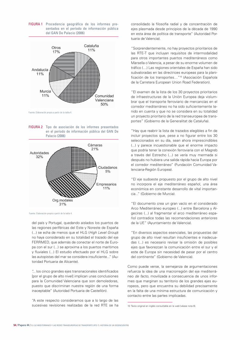
54 / Papers 44 / EL EJE MEDITERRÁNEO Y LAS REDES TRANSEUROPEAS DE TRANSPORTE (RTE-T): HISTORIA DE UN DESENCUENTRO
del país y Portugal, quedando aislados los puertos de las regiones periféricas del Este y Noreste de España (...) se echa de menos que el HLG (High Level Group) no haya considerado en su totalidad el trazado del eje FERRMED, que además de conectar el norte de Euro-pa con el sur (...) se aproxima a los puertos marítimos y fl uviales (...) El estudio efectuado por el HLG sobre las autopistas del mar se considera insufi ciente...” (Au-toridad Portuaria de Alicante).
“... los cinco grandes ejes transnacionales identifi cados [por el grupo de alto nivel] implican unas conclusiones para la Comunidad Valenciana que son demoledoras, puesto que discriminan nuestra región de una forma inaceptable” (Autoridad Portuaria de Castellón).
“A este respecto consideramos que a lo largo de las sucesivas revisiones realizadas de la red RTE se ha 10 Texto original en inglés consultable en la web (véase nota 8).
consolidado la fi losofía radial y de concentración de ejes plasmada desde principios de la década de 1990 en esta área de política de transporte” (Autoridad Por-tuaria de Valencia).
“Sorprendentemente, no hay proyectos prioritarios de las RTE-T que incluyan requisitos de intermodalidad para otros importantes puertos mediterráneos como Marsella o Valencia, a pesar de su enorme volumen de tráfi co (…) Las regiones orientales de España han sido subvaloradas en las directrices europeas para la plani-fi cación de los transportes…”10 (Asociación Española de la Carretera European Union Road Federation).
“El examen de la lista de los 30 proyectos prioritarios de infraestructuras de la Unión Europea deja vislum-brar que el transporte ferroviario de mercancías en el corredor mediterráneo no ha sido sufi cientemente te-nido en cuenta y que no se considera en su totalidad un proyecto prioritario de la red transeuropea de trans-portes” (Gobierno de la Generalitat de Cataluña).
“Hay que reabrir la lista de trazados elegibles a fi n de incluir proyectos que, pese a no fi gurar entre los 30 seleccionados en su día, sean ahora imprescindibles (...) y parece incuestionable que el enorme impacto que podría tener la conexión ferroviaria con el Magreb a través del Estrecho (...) se vería muy mermada si después no hubiera una salida rápida hacia Europa por el corredor mediterráneo” (Fundación Comunidad Va-lenciana-Región Europea).
“El eje sudoeste propuesto por el grupo de alto nivel no incorpora el eje mediterráneo español, una área económica en constante desarrollo de vital importan-cia...” (Gobierno de Murcia).
“El documento crea un gran vacío en el considerado Arco Mediterráneo europeo (...) entre Barcelona y Al-geciras (...) al fragmentar el arco mediterráneo espa-ñol contradice todas las recomendaciones anteriores de la UE” (Ayuntamiento de Valencia).
“En diversos aspectos esenciales, las propuestas del grupo de alto nivel resultan insufi cientes e inadecua-das (...) es necesario revisar la omisión de posibles ejes que favorezcan la comunicación entre el sur y el este de Europa sin necesidad de pasar por el centro del continente” (Gobierno de Valencia).
Como puede verse, la semejanza de argumentaciones refuerza la idea de una macrorregión del eje mediterrá-neo de facto, movilizada a consecuencia de unos infor-mes que marginan su territorio de los grandes ejes eu-ropeos, pero que encuentra su debilidad precisamente en la falta de una mínima estructura de comunicación y contacto entre las partes implicadas.
FIGURA 1 Procedencia geográfi ca de los informes pre-sentados en el período de información pública del GAN De Palacio (2006)
Fuente: Elaboración propia a partir de la tabla 4.
FIGURA 2 Tipo de asociación de los informes presentados en el período de información pública del GAN De Palacio (2006)
Fuente: Elaboración propia a partir de la tabla 4.

EL EJE MEDITERRÁNEO Y LAS REDES TRANSEUROPEAS DE TRANSPORTE (RTE-T): HISTORIA DE UN DESENCUENTRO / PLANIFICACIÓN DE INFRAESTRUCTURAS Y TERRITORIO. EL ARCO MEDITERRÁNEO / 55
De forma lógica, prácticamente todos los informes reco-gidos señalan la necesidad de:
1. Incorporar a los proyectos prioritarios defi nidos por la Unión Europea un eje ferroviario de ancho internacio-nal y altas prestaciones a lo largo de la costa medi-terránea desde Barcelona hasta Algeciras, bien como integrante de un eje de superior dimensión Rin-Róda-no-Mediterráneo occidental (defendido por CIERVAL-CEOE y FERRMED, por ejemplo), bien como prolon-gación del proyecto número 3 hacia el sur (Gobierno de la Generalitat de Cataluña).
2. Concretar en mayor medida el proyecto de las autopis-tas del mar con referencias explícitas a la intermodali-dad, a la conexión de los puertos mediterráneos con la red terrestre de comunicaciones y a las relaciones con el norte de África. Otras propuestas destacables fueron la defensa del eje Kiev-Lisboa como continuación oeste del corredor mediterráneo (puerto de Alicante y Ayun-tamiento de Valencia) y la conexión Valencia-Madrid-Lis-boa con el corredor mediterráneo (puerto de Valencia).
Ante este aluvión de informaciones y alegaciones, la Comi-sión Europea ha ido contestando de forma individual a las personas e instituciones implicadas (junio de 2006). En la respuesta de la Comisión se especifi ca que el informe De Palacio no podía en modo alguno “intervenir sobre las Redes Transeuropeas de Transporte que habían sido defi ni-das en la decisión nº 884/2004/CE del 29 de abril de 2004, del Parlamento Europeo y del Consejo”11, aunque señala que “la Comisión Europea toma, sin embargo, nota de sus argumentos con motivo de las orientaciones de las redes transeuropeas que deberá realizarse en el año 2010”.
Realmente, y en términos estrictos, es cierta la conside-ración de que la extensión de las RTE-T a países vecinos (materia del informe del GAN De Palacio) no podía refor-mar la propia RTE-T, pero es también cierto que, como se-ñala la alegación que la Generalitat de Cataluña dirigió a la Comisión en marzo de 2006, ambos documentos podrían haber sido abordados de forma distinta y matizada: “... la CE alega en un principio que el documento sólo refl eja los 30 proyectos prioritarios ya defi nidos en su día por Eu-ropa. Puesto que el eje mediterráneo español ferroviario no está incluido, tampoco aparece en la proposición de extensión de la red. No obstante, consideramos que los principales ejes europeos de transporte para el comer-cio internacional no corresponden forzosamente a los 30 proyectos prioritarios de la red transeuropea”12. El do-cumento aportado por el Gobierno de Cataluña acertaba al proponer que se ampliara la consideración del asunto:
11 Carta de Edgar Thielmann de fecha 12 de junio de 2006. Director de la Oficina de las RTE y desarrollo tecnológico. Dirección B-Redes Transeuropeas de Energía y Transportes. Dirección General de Energía y Transportes. Comisión Europea.
12 “Contribución del Gobierno de la Generalitat de Cataluña a la consulta pública a propósito del informe del GAN sobre la extensión de los grandes ejes de transporte transeuropeos. El eje mediterráneo español ferroviario y la viabilidad de las autopistas del mar”. Barcelona, 1 de marzo de 2006.
13 “Consulta pública sobre la extensión de los grandes ejes transeuropeos. Aportación de la Fundación Comunidad Valenciana-Región Europea”, Bruselas, 1 de marzo de 2006.
“Consideramos que, de esta manera, el documento re-fl eja una falta de coherencia por el hecho de que para Europa los proyectos en cuestión están fundamentados en relaciones internas europeas, mientras que para los países del sur los ejes considerados son los que están al servicio de las relaciones con sus países vecinos. Esta incoherencia podría ser corregida defi niendo proyectos europeos que contribuyesen realmente a la extensión de la red transeuropea y a la relación con países terceros. El eje ferroviario mediterráneo español de mercancías sería entonces una opción que tener en cuenta”. Ciertamente, el hecho de que el corredor mediterráneo no se hallase entre los 30 de la lista RTE-T difícilmente puede justifi car que no se considere idóneo para otras funciones, como la conexión con el norte de África. Este mismo argumen-to fue esgrimido por el Gobierno valenciano a través de su Fundación Comunidad Valenciana-Región Europea en Bruselas, en su propio documento: “Cuando ahora se in-tenta diseñar un eje intercontinental que enlace el norte de África y Europa, surge la limitación de que el corredor mediterráneo, al no contarse entre los 30, no es elegible. Esto nos lleva a la situación absurda de que los trenes que lleguen a Algeciras desde Marruecos (...) tendrían que en-caminarse hacia Figueres a través de la meseta”13.
5. Consecuencias del diseño de las RTE-T: las inversiones entre 1986 y 2002
El diseño de las RTE-T ha tenido, además de la margina-ción del eje mediterráneo observada en los mapas y en las listas de proyectos, un añadido preocupante, aunque lógico: la concentración de la inversión proveniente de Europa y destinada a las RTE-T en regiones españolas ajenas al eje mediterráneo, especialmente Madrid. De acuerdo con los cálculos efectuados en un documento interno elaborado en 2003 en el seno de la cátedra Igna-si Villalonga, del Institut d’Economia i Empresa Ignasi Villalonga, pudimos concluir que el 43% de los fondos y las subvenciones relacionadas con las RTE-T dedicados a España en el período 1986-2002 fueron a parar de for-ma exclusiva a proyectos relacionados con infraestructu-ras de la Comunidad de Madrid, por el 7,8% a Cataluña y el 5,6% a Madrid. Por extensión, el 37% de las subven-ciones RTE-T para España fueron a parar a ejes ferrovia-rios radiales (Madrid-Valencia o Madrid-Barcelona) y sólo el 6,5% al corredor ferroviario mediterráneo, el Valencia -Barcelona. En resumen, la Comunidad de Madrid se encontró, directa o indirectamente, recompensada con el 80% de los fondos promovidos por las RTE-T para Es-paña en el período 1986-2002. En estas cantidades diri-gidas de forma extraordinaria hacia el centro peninsular primaron tanto los ejes de alta velocidad Madrid-Sevilla como los radiales hacia Valladolid, Valencia y Zaragoza. Indudablemente, la política de RTE-T ha aumentado la

56 / Papers 44 / EL EJE MEDITERRÁNEO Y LAS REDES TRANSEUROPEAS DE TRANSPORTE (RTE-T): HISTORIA DE UN DESENCUENTRO
concentración de fondos en operaciones que, ni de le-jos, han suavizado la tradicional radialidad del diseño de las infraestructuras españolas.
6. Conclusión: el cambio de la metodología “ascendente” y el horizonte de revisión de 2010
Como se ha visto, la construcción de la Red Transeuro-pea de Transportes se ha ido conformando lentamente desde 1990 hasta 2006 con una metodología que ha refl ejado fi elmente el espíritu del proceso de unifi ca-ción europea en los últimos decenios: un intento de in-crementar la cohesión —territorial, en este caso— de Europa, pero desde bases y con métodos en los que el peso de los Estados miembros ha sido determinan-te y condicionante. La evolución de la RTE-T y de las sucesivas listas de proyectos prioritarios ha respondido a un pensamiento práctico “confederal” más que a un espíritu federal. La decisión de Essen (1994) y de la Co-misión (en 2004, 10 años después) de establecer una serie de proyectos prioritarios (14 en el primer caso, 30 en el segundo) ha marcado el proceso posterior hasta la actualidad. La prioridad, como se ha evidenciado, se asentaba sobre aspectos que, pese a las declaraciones y los criterios esgrimidos, respondía mucho más a los intereses de los Estados y a refl ejar su particular visión del territorio nacional que a construir una auténtica cohe-sión territorial a escala europea. Sólo así se entiende la marginación por parte de las RTE-T de un espacio como el eje mediterráneo, que concentra una gran actividad económica a la que se suma su papel de fachada marí-tima de relación con el norte de África. Esta crítica no la rea lizamos solamente nosotros a la vista de los mapas y del reparto de fondos ligados a las RTE-T. El propio informe Van Miert de 2003 (página 72 de la versión en castellano) aconsejaba la modifi cación de la metodolo-gía de defi nición de prioridades, en un párrafo que ha pasado, desgraciadamente, sin excesiva repercusión: “En vista de la integración de la Red Transeuropea de Transportes, el enfoque ascendente ya no es sufi ciente en sí mismo para determinar los proyectos prioritarios. Ningún Es ta do miembro puede afi rmar tener una ima-gen global de las necesidades de transporte a escala de la Unión ampliada” (la cursiva es del autor). En conse-cuencia, se abogaba por la creación de un Observatorio Europeo de Transportes que, entre otras funciones, “ayudaría a la Comisión (...) formulando propuestas para la elección de los proyectos prioritarios...” .
La perspectiva estatal, la propia de cada Estado-miem-bro –lo que el informe Van Miert defi ne como “enfoque ascendente”–, ha sido la que ha tenido prioridad en este proceso y la que ha marginado al eje mediterráneo de las RTE-T. Y no solamente en los Consejos Europeos, hasta cierto punto una cuestión lógica dado que se tra-ta de reuniones precisamente de Estados miembros, sino en las iniciativas de la propia Comisión. Signifi ca-tivamente, los tres grupos de alto nivel (GAN) creados
entre 1994 y 2004 para tratar el asunto de las RTE-T, se formaron mediante la agregación de representantes de los Estados. En el caso del GAN Van Miert (creado a fi nales de 2002), el representante español fue Antonio López-Corral, director general de Programación Econó-mica del Ministerio de Fomento, que por entonces tenía como ministro a Francisco Álvarez Cascos (del Partido Popular). A cada Estado miembro le correspondió un representante, a los que se sumaron observadores de los países aspirantes, más un representante del Banco Europeo de Inversiones. De igual forma, para la concre-ción del GAN De Palacio (otoño de 2004), fue designado nuevamente un representante por cada Estado miem-bro, más otros de países en vías de incorporación o con relaciones geográfi cas de proximidad con la Unión Europea. Otra vez, un representante del Ministerio de Fomento, en esta ocasión ya bajo el ministerio de Mag-dalena Álvarez (del PSOE) –en concreto Pablo Vázquez (director de Prospectiva y Estudios de Transporte)–, fue el elegido para representar a España, a quien acompañó Pilar Castro, jefa de servicio del propio ministerio. Con esta metodología, incluso las iniciativas de la Comisión se dejaron en manos de los Estados miembros y, con-secuentemente, de su lógica territorial. No es preciso señalar que en Estados como España, con fuerte tra-dición centralista y una óptica radial de las infraestructu-ras, la transposición a escala europea de estos mismos principios fue bastante fi el. De otra manera no se explica que ni siquiera en la Lista 2 de Van Miert —recordemos, aquella confi gurada por proyectos con “un valor añadido europeo muy alto”— se incluyera el corredor mediterrá-neo de Algeciras a Francia —e incluso más allá, tanto por el sur como por el norte—, enlazado con los dinámicos puertos del Mediterráneo occidental.
En realidad, la tan perseguida cohesión económica, social y territorial de la Unión Europea, y que la RTE-T pretendía alcanzar, ha descansado en la articulación, a veces forzada, de proyectos individuales presentados por sus diferentes Estados miembros. Siempre que Europa ha propuesto una lista de proyectos prioritarios o ha confeccionado un mapa, lo ha hecho a partir del material proporcionado por altos funcionarios o cargos políticos provenientes de los órganos centrales de los Estados. A nuestro entender, este hecho revela, por una parte, la debilidad de la Unión Europea para conseguir una estructuración que no sea la mera agregación de Estados —y de sus intereses— y, por otra, explica la escasa relevancia que el eje mediterráneo ha tenido en esta historia de las RTE-T. En defi nitiva, las RTE-T han ido confi gurándose de forma relacionada y ligada es-trechamente a la visión que cada Estado aportaba a las comisiones, los consejos europeos o los grupos de alto nivel. De esta forma, en el caso español, como se ha visto tanto en el análisis de los proyectos seleccionados como de las inversiones realizadas hasta 2002, las RTE-T han supuesto marginación del eje mediterráneo —con el consiguiente riesgo de que su ya de por sí elevado ca-rácter periférico respecto al centro de gravedad eu ropeo

EL EJE MEDITERRÁNEO Y LAS REDES TRANSEUROPEAS DE TRANSPORTE (RTE-T): HISTORIA DE UN DESENCUENTRO / PLANIFICACIÓN DE INFRAESTRUCTURAS Y TERRITORIO. EL ARCO MEDITERRÁNEO / 57
se incremente en el futuro—, transposición a escala europea de los principios de radialidad de la tradicional concepción española en materia de infraestructuras e incremento del propio “carácter radial de las comunica-ciones españolas, aumentando la fuerte concentración existente en los transportes españoles” (como afi rmaba textualmente el documento de la Cámara de Comercio de Murcia14 ante el período de exposición pública del in-forme de De Palacio en 2006). Sólo así se entiende que el eje mediterráneo, que concentra una gran parte de la actividad económica, logística y de transportes de Espa-ña, no haya sido previsto en ninguno de los proyectos prioritarios emanados de las RTE-T desde 1990 hasta 2006, exceptuando las menciones genéricas a las auto-pistas del mar y a la convertibilidad en alta velocidad de la red ferroviaria de España, cuestiones que, no siendo
menores, no alcanzan la concreción de otros proyectos mucho más singularizados.
Con vistas a la revisión de 2010, nadie podrá ya argu-mentar la falta de objetivos estratégicos por lo que res-pecta al eje mediterráneo. Se necesita una coordinación de esfuerzos entre gobiernos, asociaciones e institucio-nes de todo tipo del eje mediterráneo, de Andalucía a Cataluña en este caso, pasando por el Comunidad Va-lenciana, Murcia y las Islas Baleares —y sin descartar las regiones francesas afectadas— para que esta ma-crorregión económica cuente, a partir de esa fecha, con proyectos prioritarios para la cohesión de la Unión y el desarrollo de la economía de esta fachada mediterránea. Coordinación de esfuerzos, defi nición clara de los objeti-vos estratégicos y de los proyectos prioritarios a escala del eje mediterráneo y política informativa decidida hacia Madrid y Bruselas tienen que ser objetivos que guíen la acción de las sociedades y economías implicadas en los años que restan hasta la revisión de las RTE-T.
Bibliografía
Boira, J.V. (2003 a); “L’eix mediterrani. De les bases intel·lectuals històriques a la realitat econòmica actual”, Debats Tecnològics, nº 20, Barcelona.
Boira, J.V. (2003 b); “La perspectiva interregional i l’economia i el territori d’Espanya. L’eix mediterrani”. Memòria Econòmica de Ca-talunya 2003. Cambra de Comerç de Barcelona, págs. 303-315.
14 Alegaciones de la Cámara Oficial de Comercio de Murcia al GAN sobre la red para la paz y el desarrollo de noviembre de 2005. Murcia.
Boira, J.V. (2003 c); Transport per carretera i fl uxos interregio-nals. El paper de l’eix mediterrani. Documents Euram, núm. 3. Institut Ignasi Villalonga, Valencia.
Ellwanger, G., y M. Wilckens (1994); “High Speed for Europe”. Japan Railway and Transport Review, núm. 3.
58 / Papers 44 / PERSPECTIVAS DE DESARROLLO DEL SISTEMA DE TRANSPORTE EN EL MEDITERRÁNEO
PERSPECTIVAS DE DESARROLLO DEL SISTEMA DE TRANSPORTE
EN EL MEDITERRÁNEO
SUMARIO
1. Retos en el ámbito de la Europa del sur
2. Fuerte aumento del tráfi co de todos los modos de transporte
3. Un reparto modal problemático
4. Hacia una saturación progresiva de los ejes de transporte
5. Grandes proyectos ferroviarios este-oeste
6. Un proyecto ferroviario que estructure el norte con el sur: FERRMED
7. Las autopistas del mar
8. Un espacio aeroportuario intermedio en Europa
9. Una política europea de transporte inactiva

PERSPECTIVAS DE DESARROLLO DEL SISTEMA DE TRANSPORTE EN EL MEDITERRÁNEO / PLANIFICACIÓN DE INFRAESTRUCTURAS Y TERRITORIO. EL ARCO MEDITERRÁNEO / 59
1. Retos en el ámbito de la Europa del sur
El Esquema del Desarrollo del Espacio Comunitario (EDEC) promulgado por Europa preconiza la constitución, en el sur de Europa, de una “zona de integración económica” de nivel mundial que acoja los grandes polos europeos empezando por Sevilla, y pasando por Valencia, Barcelona, Lyon, Marsella, Génova, Turín, Milán, Roma, Nápoles, etc., que pueda servir como contrapeso a las regiones del polígono central de Europa. Esta estrategia supone, en concreto, la implementación de un sistema de transporte competitivo en este espacio que permita, de manera efi caz y duradera, garantizar la circulación de personas y mercancías durante un largo período.
Ahora bien, en el Mediterráneo, el problema de los transportes se ha convertido en la actualidad en un obs-táculo. Las cordilleras (Apeninos, Alpes, Macizo central, Pirineos) fraccionan el espacio y constituyen un freno importante para la circulación de los fl ujos. Como con-secuencia de ello, las redes terrestres son discontinuas, poco coherentes y están muy saturadas, lo que supone un inconveniente en relación con la Europa del norte, que, desde este punto de vista, está mucho mejor equi-pada. Por consiguiente, los costes de transporte norte-sur o este-oeste son de los más caros del mundo.
Este espacio tampoco dispone de un sistema organizado de vías de agua como las que tienen una función estruc-turante en los intercambios de la Europa del Rin o del Danubio. Por este motivo, el transporte ferroviario debe-ría tener una función mucho más relevante; sin embargo, como se verá más adelante, este sector de transporte sufre un retraso notable en materia de infraestructuras. Ello comporta que se opte más por el transporte por ca-rretera, que presenta unos inconvenientes en asuntos medioambientales que son aún más importantes debido a que las redes se concentran en corredores a causa de la fragmentación geográfi ca del espacio.
Así pues, la consolidación de las redes de transporte constituye un reto esencial para la zona del Mediterrá-neo. Esta consolidación implica, en concreto, el desarro-llo de conexiones este-oeste que son a la vez transalpi-nas, litorales, aéreas y marítimas. Para ello es necesario
PERSPECTIVAS DE DESARROLLO DEL SISTEMA DE TRANSPORTE EN EL MEDITERRÁNEO1
JEAN-CLAUDE TOURRETDelegado general
Institut de la Méditerranée
franquear las barreras físicas alpinas y pirenaicas, entre otras, sin olvidar algo tan imprescindible como el refuer-zo de las comunicaciones entre los corredores litorales y las zonas interiores que son mucho menos accesibles.
En lo que se refi ere al transporte marítimo, su función sigue siendo más preponderante en los intercambios mundiales gracias al desarrollo de la contenedorización. Pero la orilla mediterránea de Europa aún debe alcan-zar un lugar más importante en este ámbito. La práctica del cabotaje es un complemento muy oportuno para los corredores terrestres. Además, es una herramienta in-eludible del servicio de transporte insular, ya sea para sus relaciones con el continente o para las conexiones entre las islas. Dado que el Mediterráneo es una de las vías marítimas más usadas del mundo, la cuestión de la seguridad de este modo de transporte interesa eviden-temente a los países y regiones costeros.
Asimismo, para el espacio mediterráneo una mejor organización de la logística constituye un reto muy impor tante. Los transportes solamente desempeñarán plenamente su función en la medida en que se sepa integrar, interconectar y operar en un mismo sistema los diferentes modos terrestres, marítimo y aéreo que comu-nican esta zona geográfi ca. A ello contribuirá ampliamente el uso de la informática, la telemática y las tecnologías para el control y la seguridad, así como para la gestión integrada de los datos y los documentos de transporte.
2. Fuerte aumento del tráfi co de todos los modos de transporte
Como se ha comentado anteriormente, los intercambios –es decir, el tráfi co de personas y mercancías– en el seno del espacio mediterráneo están destinados a desarrollar-se a un ritmo rápido durante los próximos años debido al efecto combinado de la integración europea (cuyos efec-tos aún están lejos de completarse), de la ampliación de Europa a 10 nuevos países miembros y a un fuerte dinamismo de las economías asiáticas, gran parte de cuyos intercambios con Europa transita por el Medite-
1 Traducido del original francés.
60 / Papers 44 / PERSPECTIVAS DE DESARROLLO DEL SISTEMA DE TRANSPORTE EN EL MEDITERRÁNEO
rráneo. También podemos pensar que, en el futuro, las economías del sur del Mediterráneo contribuirán a esta dinámica que sitúa el espacio mediterráneo en el centro de los nuevos fl ujos de la globalización.
La integración europea sigue siendo un vector importante de desarrollo de los tráfi cos terrestres. Pero, como se ha visto anteriormente, la construcción europea aún no ha eliminado las fronteras –nada más lejos–, que si-guen siendo un obstáculo importante para los intercam-bios, que básicamente continúan realizándose a escala nacional. También se observa que, con frecuencia, las fronteras dividen los fl ujos por diez, lo cual muestra el camino que queda por recorrer antes de alcanzar una unifi cación absoluta del mercado interior y la presión que ello supondrá para el sistema de transporte europeo.
Por consiguiente, los fl ujos de personas y de mercan-cías, alrededor del arco mediterráneo y, en particular, en el corredor Barcelona, Lyon, Marsella, Turín y Génova están experimentando una gran expansión. El aumento de tráfi co, teniendo en cuenta todos los modos de trans-porte, es del orden del 10% anual; es decir, se duplica cada siete años.
Este dinamismo de los fl ujos también afecta a las activi-dades turísticas. Así, la actividad de cruceros en el Me-diterráneo ha experimentado un desarrollo considerable. El número de cruceristas ha pasado de 7,5 millones en 1997 a cerca de 11 millones en 2005; es decir, un creci-miento del 6% anual.
3. Un reparto modal problemático
El principal freno a una mejor circulación del tráfi co en la Europa del sur no es tanto un problema de capacidad como de reparto modal de los transportes, dominado por la carretera.
La oferta ferroviaria entre Italia y Francia es, en efecto, poco competitiva tanto en términos de coste como de servicio. Actualmente se necesitan cerca de ocho horas para realizar el trayecto entre Marsella y Milán. El coste también es poco atractivo respecto al del avión. En los Alpes del sur, la situación es especialmente mala: redes mal conectadas, explotación problemática del lado ita-liano (salvo en el caso del transporte combinado, que es muy competitivo), falta de conexión entre Modane y Menton. Por consiguiente, el tráfi co de mercancías por ferrocarril entre Francia e Italia es aproximadamente sie-te veces menor del que se realiza por carretera, y sigue bajando regularmente.
Entre España y Francia, la oferta ferroviaria también es muy insufi ciente debido, especialmente, a la diferencia de ancho de vía de la red española, que obliga a realizar un transbordo en las estaciones fronterizas (salvo los tre-nes directos, como el Talgo). Actualmente el trayecto en
tren de Barcelona a Perpiñán dura más de tres horas, y el de Barcelona a Marsella, más de seis. Por este motivo, más del 85% de los fl ujos de mercancías entre España y Francia se realizan por carretera.
Las conexiones por carretera entre estos dos países so-lamente son efi caces en los dos extremos del macizo. El paso por la costa que conecta Perpiñán y Barcelona constituye el eje privilegiado de tránsito entre el este y oeste. Este eje, que aún está lejos de saturarse, sigue registrando de todos modos un índice de crecimiento anual del tráfi co de cerca del 8%.
En lo que se refi ere a los pasos en los puntos fronterizos, éstos aún no están saturados. Sin embargo, los tráfi cos entre la frontera española y la francesa se desarrollan a un ritmo cercano al 10% anual.
4. Hacia una saturación progresiva de los ejes de transporte
Un reciente informe francés de auditoría sobre los grandes proyectos de infraestructuras de transporte confi rma los riesgos de saturación de las carreteras en el Arco Medite-rráneo entre Barcelona y Génova en un plazo de 15 años.
El corredor del Languedoc es especialmente representati-vo de esta situación. Este eje, medido entre Nimes y Nar-bona, lo recorren 75.000 vehículos diarios (mientras que la Dirección de Carreteras establece el umbral de molestia en 65.000 vehículos diarios como media anual) y más de 41.000 vehículos al día hasta la frontera española.
Los principales embotellamientos se producirán:
– En España, en la periferia de la región metropolitana de Barcelona.
– En Francia, en la confl uencia de las autopistas A61 y A9 (Narbona), en la A9 entre Nimes y Montpellier y en la A8 cerca de Aix-en-Provence y Niza.
– En Italia, en la autopista costera (principalmente Savo-na-Génova) y en la región de Milán, donde la red de carreteras está especialmente saturada.
Los puntos de saturación tienden igualmente a concen-trarse en las principales ciudades, allí donde el tráfi co local confl uye con el tráfi co de tránsito.
5. Grandes proyectos ferroviarios este-oeste
Los proyectos de nuevas infraestructuras como Lyon-Tu-rín, TGV2 franco-español, TGV Rin Ródano, LGV3 Proven-
2 Tren de alta velocidad.3 Línea de alta velocidad.

PERSPECTIVAS DE DESARROLLO DEL SISTEMA DE TRANSPORTE EN EL MEDITERRÁNEO / PLANIFICACIÓN DE INFRAESTRUCTURAS Y TERRITORIO. EL ARCO MEDITERRÁNEO / 61
za-Alpes-Costa Azul, Génova-Milán, y sus conexiones, modifi carán profundamente (si se realizan) el paisaje de la alta velocidad redibujando de manera duradera la for-ma y el volumen de los intercambios.
El Lyon-Turín constituye un eslabón perdido esencial en el Eje 5 europeo, que va desde Lisboa hasta Kiev, en el que los tráfi cos aumentarán mucho como consecuencia de la ampliación europea. Evidentemente, este eslabón es estratégico para el conjunto del espacio Medoc4 porque representa una posibilidad de transferir al modo ferroviario parte del crecimiento del fl ete tradicional o de que los ca-miones realicen el transporte por la autopista ferroviaria.
También es estratégica la terminación de la línea de alta velocidad Barcelona-Marsella-Génova, que hace que del la do francés la LGV PACA5 se considere un eslabón del segmento transnacional.
La nueva línea ferroviaria Languedoc-Roussillon, destina-da tanto al tráfi co de pasajeros como al de mercancías, constituye, en términos de impacto, una solución que debería permitir lograr la terminación de la línea de alta velocidad entre Perpiñán y Montpellier, prevista en el mejor de los casos para 2025.
En total, el conjunto de los proyectos de la línea de alta velocidad examinados en España, Francia e Italia, permi-tirán mejorar considerablemente la “gran accesibilidad” ferroviaria de las metrópolis en el espacio Medoc. Así, cerca del 2030, Marsella podría encontrarse, en el mejor de los casos:
– Gracias a la LGV PACA: a aproximadamente 2 h 45 min de Génova y a 3 h 30 min de la metrópolis lombarda, sabiendo que el tiempo de trayecto con Génova y Mi-lán podría aún reducirse mediante la prolongación de la LGV CA6 hacia Ventimiglia 1.
– Gracias a la línea Lyon-Turín: a cerca de tres horas de la capital piamontesa –en este sentido debería buscarse una oferta de servicio.
– Con la LGV Languedoc-Roussillon: a un poco menos de tres horas de la metrópolis catalana (y a unas tres horas de Toulouse), siempre y cuando se realice la sección Montpellier-Perpiñán, algo que actualmente parece una hipótesis optimista (la fecha de 2030 es la que más suele mencionarse), sin la cual los trayectos se alargarían cerca de 45 minutos.
Las fechas anunciadas para la terminación de las co-nexiones este-oeste son, como se ve, lejanas (del 2025 al 2030), y la experiencia ha demostrado que los aplaza-mientos de los plazos son frecuentes en este ámbito.
En este intervalo, se teme una saturación progresiva de los ejes ferroviarios y de carreteras, lo cual constituye un inconveniente muy importante para la integración de este espacio.
6. Un proyecto ferroviario que estructure el norte con el sur: FERRMED
Actualmente, una asociación denominada FERRMED, cuyo objetivo consiste en promover el eje ferroviario de mercancías Rin-Ródano-Mediterráneo occidental, está promoviendo la creación de un eje ferroviario que es-tructure el norte con el sur. El tronco principal del eje FERRMED comienza en Duisburgo, conecta en abanico Escandinavia, Gran Bretaña, todos los puertos marítimos del mar del Norte y los del oeste del mar Báltico, une los principales puertos fl uviales, pasa por los valles del Rin y del Ródano y por toda la costa mediterránea occidental desde Marsella hasta Algeciras, e interconecta los ejes este-oeste más importantes de la Unión Europea. Esto descongestionaría gran parte del tráfi co transeuropeo de mercancías, que se concentra en las carreteras y au-topistas del eje Rin-Ródano-Mediterráneo occidental, las cuales ya están al borde de la saturación.
La costa mediterránea española y francesa, así como los valles del Rin y del Ródano constituyen un territorio que no presenta obstáculos geográfi cos importantes. Por este motivo, hace siglos que las vías de transpor-te y de comunicación entre el norte y el sur de Europa pasan por ese eje. Los puertos del mar del Norte han sido desde siempre unos centros económicos y comer-ciales muy importantes para Europa. Además, debido a la emergencia económica de los países asiáticos y a la proximidad con África, el comercio en los puertos del Mediterráneo está experimentando año tras año un cre-cimiento espectacular.
El Eje FERRMED es el camino de interconexión más rápido entre el mar del Norte, el oeste del mar Bálti-co y el Mediterráneo. Este eje une el norte y el sur de Europa y representa también un lugar de paso obligado para el transporte de mercancías entre el este y oeste. En el 2005, el tráfi co terrestre de este eje en el paso de los Pirineos superó los 40 millones de toneladas y todas las previsiones indican que hasta el año 2010 aumentará en un 50%.
Pero la importancia económica del eje FERRMED va más allá de las zonas que atraviesan su tronco principal y el abanico de interconexión del sector norte con la costa mediterránea española y francesa, los valles del Rin y del Ródano, el noreste de Alemania, el Benelux y la mitad sur de Escandinavia. Su importancia alcanza numerosas re-giones en Alemania, Austria, Bélgica, Dinamarca, España, Francia, Países Bajos, Italia, Luxemburgo, Polonia, Portu-gal, República Checa, Reino Unido, Suecia, Suiza, Marrue-cos, Argelia y Túnez.
4 Mediterráneo occidental.5 Línea de alta velocidad Provenza-Alpes-Costa Azul.6 Línea de alta velocidad Costa Azul.

62 / Papers 44 / PERSPECTIVAS DE DESARROLLO DEL SISTEMA DE TRANSPORTE EN EL MEDITERRÁNEO
Una revitalización del eje FERRMED permitiría, en línea con las directivas europeas, una mejor interconexión en-tre las regiones europeas y garantizaría, por consiguiente, una ordenación coherente del territorio europeo.
Finalmente, la revitalización del eje FERRMED permitiría un desarrollo intermodal equilibrado entre la red terres-tre, las líneas fl uviales y las líneas marítimas del mar del Norte, del oeste del mar Báltico y de la cuenca medite-rránea occidental. Asimismo, su revitalización fomenta-ría la práctica del cabotaje.
7. Las autopistas del mar
La saturación progresiva de los ejes de transporte terres-tre del Arco Latino ha conducido, desde hace varios años, al establecimiento de conexiones marítimas que hacen la competencia a la autopista terrestre existente con el objetivo de utilizar un modo de transporte me-nos contaminante y menos costoso en infraestructuras. Ya existen conexiones de este tipo, especialmente en-tre España e Italia, gestionadas por empresas privadas que operan en distancias de 1.000 kilómetros y más. La Comisión Europea desea fomentar el desarrollo de este tipo de conexión en el Mediterráneo en distancias más cortas y ha aplicado varios programas sucesivos en este sentido. Sin embargo, estas conexiones, deno-minadas “autopistas del mar”, que se inscriben en una lógica que podría defi nirse como el transporte marítimo de ca miones, tienen difi cultades para desarrollarse. En 2003 se proyectó una conexión entre Fos y Savona, pero no se ha llegado a crear. Desde 2004, otra conexión fun-ciona entre Toulon y Roma con una ayuda europea, pero su balance no es muy positivo.
Sin embargo, cabe tener en cuenta que el verdadero concepto del transporte marítimo de camiones aún no se ha desarrollado a día de hoy y que los diferentes ac-tores, en concreto los transportistas por carretera, lo te-men especialmente. En efecto, este proyecto topa con varios obstáculos, algunos de los cuales la Comisión Eu-ropea los identifi có en su comunicación del 2 de julio de 2004; según este texto, el cabotaje no está totalmente integrado en la cadena de suministro de puerta a puerta, está sometido a unos procedimientos administrativos complejos y requiere un nivel elevado de efi cacia de los puertos.
También se debe tener en cuenta la existencia de un hin-terland comercial y técnico, las tasas y tarifas portuarias, la falta de frecuencia y regularidad y la gran inclinación por la carretera.
Así pues, es preciso hacer frente a esta constatación. En primer lugar, es evidente que los Estados deben interve-nir con fuerza, garantizando especialmente la duración, para que los diferentes actores, cargadores, armadores, transportistas, se arriesguen a invertir en estos pro-
yectos. Además, conforme a las preconizaciones de la Comisión, parece necesario crear unas taquillas únicas que agruparían a todos los actores de la cadena logísti-ca (cargadores, armadores, transportistas por carretera, ferroviarios, fl uviales) y podrían proponer a los clientes la gestión de la totalidad de las operaciones.
Finalmente, la modernización de los puertos, y la mejora de su servicio de transporte, especialmente el ferrovia-rio, es una condición sine qua non para que estas líneas tengan éxito. De este modo se podrá constatar que el coste de transportar un contenedor por tierra puede ser, en distancias de 500 kilómetros, cinco o seis veces ma-yor que transportarlo por vía portuaria. Por este motivo, los puertos que no se doten de servicios competitivos estarán condenados a ser puertos secundarios en el transporte de contenedores. También es preciso apun-tar que la apertura a las empresas ferroviarias europeas constituye un reto muy importante para los grandes puer-tos franceses, que, a diferencia de sus competidores, no disponen de una red fl uvial de dimensión europea.
8. Un espacio aeroportuario intermedio en Europa
El contexto aeroportuario europeo se caracteriza, ante todo, por una concentración de la actividad en un número restringido de aeropuertos situados en el norte del continente europeo. Los grandes hubs del norte de Euro-pa (al igual que los puertos de Amberes y de Rot terdam) estructuran la organización del cielo eu ropeo. Para las grandes compañías aéreas europeas y sobre todo para las transcontinentales, los aeropuertos del espacio Medoc7 desempeñan principalmente una función de ali-mentador para los hubs de Amsterdam-Schiphol, Roissy-Charles de Gaulle (París), Londres- Heathrow, Frankfurt, etc.
Sin duda, la Europa mediterránea cuenta con grandes aeropuertos, situados especialmente en las capitales (Madrid, Roma, Atenas), pero, comparativamente, la ac-tividad en dichos aeropuertos es más difusa. Aparte de los mencionados, existe una red más extensa formada por aeropuertos de tamaño más modesto (Barcelona, Málaga, Marsella, Lyon, Génova y Sevilla). Mientras que el de Barcelona es de un tamaño equivalente a los aeropuertos de las capitales española e italiana, los otros cinco pueden califi carse de intermedios. En la red de los aeropuertos europeos, Barcelona se encuentra entre los de segundo nivel (después de los de Londres y París, y en el mismo nivel que Madrid y Roma), tres aero-puertos (Málaga, Marsella y Lyon) se hallan en el tercer nivel, mientras que los de Génova y Sevilla se sitúan en el cuarto nivel.
Las aglomeraciones urbanas no disponen tampoco de un servicio idéntico en el ámbito de la conexión ferrovia-
7 Mediterráneo occidental.

PERSPECTIVAS DE DESARROLLO DEL SISTEMA DE TRANSPORTE EN EL MEDITERRÁNEO / PLANIFICACIÓN DE INFRAESTRUCTURAS Y TERRITORIO. EL ARCO MEDITERRÁNEO / 63
ria. La ciudad de Lyon es la única que dispone de una in-terconexión del aeropuerto con el tren de alta velocidad. Si bien esta articulación aún está poco optimizada, re-presenta una baza realmente importante para el futuro.
La accesibilidad entre las metrópolis del espacio Medoc es muy variable: buena en Barcelona, media en Lyon y Marsella y reducida en Génova y Málaga. Puesto que estos aeropuertos no están conectados entre sí directa-mente, algunos están más alejados que otros en tiempo. Así, se necesitan entre tres y siete horas para conectar Génova y Marsella, y Sevilla tiene tres conexiones que provienen de otras metrópolis del Medoc superiores a cuatro horas.
Finalmente, el espacio Medoc sufre una insufi ciencia de puntos de entrada aeroportuarios intercontinentales, que siguen siendo exclusividad de los aeropuertos de las capi-tales. Sin embargo, los tráfi cos transcontinentales a par-tir y hacia estas ciudades son importantes. Únicamente se podrá hacer evolucionar las estrategias de hub de las grandes compañías aéreas, que favorecen la concentra-ción de las conexiones intercontinentales en un número muy limitado de aeropuertos, mediante el impulso de una coordinación entre plataformas aeroportuarias.
9. Una política europea de transporte inactiva
La política europea del transporte nunca ha sido muy partidaria del desarrollo de los grandes ejes de transpor-te en el Mediterráneo. Las movilizaciones políticas y las grandes inversiones apoyadas por la Comisión Europea se siguen destinando al norte. Así, entre los grandes proyectos aceptados por la Comisión, la gran mayoría
conciernen a la Europa septentrional. Asimismo, los puertos del norte han captado gran parte del tráfi co que geográfi camente debería llevarse al sur.
Los Estados que siguen siendo responsables de las grandes infraestructuras de transporte aplican sus pro-pias estrategias y sólo toman como referencia la política europea cuando ésta benefi cia sus intereses.
En el Mediterráneo, los proyectos estructurantes se tratan en el seno de las comisiones intergubernamentales fran-co-españolas y franco-italianas. Estas Comisiones suelen solucionar por lo general los problemas que plantean los tramos transfronterizos como es el caso de Lyon-Turín o de la línea ferroviaria de alta velocidad Perpiñán-Figueres. En cambio, no interfi eren en los proyectos nacionales.
Esta situación de desconexión de las políticas europeas y de las políticas nacionales está llamada a perdurar. En efecto, la Dirección General de Transportes no debería recibir una dotación para el próximo programa presu-puestario 2007-2013 de 7.000 millones de euros cuando había pedido casi 20.000 millones. Así pues, sus medios de intervención están limitados, lo que hace suponer que para las grandes estructuras europeas se recurrirá en mayor medida a la fi nanciación privada. Por este mo-tivo, la oportunidad se evaluará cada vez más proyecto a proyecto. Dada esta situación, existe el riesgo de que dis-minuya la referencia a las grandes prioridades europeas promulgadas por la Comisión. Este temor se refi ere, en concreto, a los numerosos proyectos en el Mediterráneo que pueden considerarse importantes dentro de una perspectiva de integración europea, pero cuya rentabi-lidad no es sufi cientemente elevada para que, al menos parcialmente, sean fi nanciados por el sector privado.

INFRASTRUCTURE PLANNING AND TERRITORY. THE MEDITERRANEAN ARC / 65
PRESENTATION
The exploration of the relationship between infrastructures and territory in one the axis that articulates the Spanish and European territory, the Mediterranean Arc, was the objective of the course organised by the CUIMPB (La planifi cación de las infraestructuras y el territorio. El arco mediterráneo, November 2005), coordinated by Carme Miralles-Guasch, director of the IERMB, and Ángel Aparicio, director of the CEDEX. The underlying thesis of three days of sessions was the change of paradigm that has been occurring in recent years in relation to the challenge of providing infrastructures with a territorial dimension from a dialectic perspective, with more emphasis on synergy and interrelations, and through the inclusion not only of physical and economic variables, but also of social and environmental ones. And although ter ritorial dynamics are processes that in their genesis, development and implantation imply long-term time arcs, they cannot ig nore the need to relate territorial scales of variable geometry. An example of this is, unquestionably, the Mediterranean Arc.
This was the origin and the conceptual framework that was the inspiration for issue 44 of Papers magazine on the Mediterra nean Arc, understood to be a spatial axis in which different territorial scales are interrelated and in which there are some infrastruc tures (constructed or planned) that differ greatly from what could be defi ned as a multilevel network. In its analysis of this European space, the magazine features the collaboration of several specialists from a variety of origins, namely Turin, Marseille, Valencia and Barcelona, and different disciplines.
The fi rst article, by Francesc Carbonell and Josep Báguena, analyses the process of constructing the Mediterranean Arc as a counterbalance of the infl uence of northern territories in Europe; this is a bidirectional process because it stems both from the European Commission and from the Mediterranean regions, the objective being to reach a consensus in terms of key policies on supraregional scales. One of these po licies is undoubtedly that of transport and infrastructures, a matter that appears in all of the articles in this issue of Papers.
Francesca Governa explores the vision of infrastructures as being trans-scale territorial projects that should not only be conceived in relation to the geographic/geoeconomic/geopolitical scale that justifi es their construction, but also through
INFRASTRUCTURE PLANNING AND TERRITORY. THE MEDITERRANEAN ARC
lesser and multiple hierarchical scales. She bases her analysis of the relationship between infrastructures and territory on the concepts of territorial congruence and multilevel government to guarantee that planning is carried out by all of the agents in the territory. Along similar lines of argument, Joaquín Farinós, in relation to the accessibility requirements of infrastructures in all of the territories of the EU, promotes the need for planning activities to be coherent and to consider inter-modal integration as a guarantee of local development and territorial cohesion. He analyses the Mediterranean Arc as an example of the specialisation of territories in polycentric Europe and underlines three key aspects for the success of the project: technical capacity, the mobilisation of agents and political leadership.
In his article, Josep Vicent Boira analyses how, despite the cohesion of the Mediterranean Arc and its strong business and social relations, there has been a loss of political interest in its physical materialisation. He presents several reasons for this (the limited interest of the EU, the lack of permanent institutional organisation in the region) that, combined with the system of assigning projects in the EU, in which national in terests are rewarded ahead of criteria on a European scale, have prevented the axis from being consolidated. Meanwhile, the concept of a radial Spain has not benefi ted the development of the north-south axes that structure the peninsula.
Jean-Claude Tourret emphasises in the fi fth article the importance of consolidating a common transport network in order for the Mediterranean Arc itself to be more internally coherent. However, he is aware of the existing dysfunctions in the network of infrastructures located along the Western Mediterranean coast, especially concerning railways, and the political diffi culties of the unitary conception of infrastructures beyond the state level.
THE PROCESS OF CONSTRUCTION OF THE MEDITERRANEAN ARC: A TWO-WAY STREET
Francesc CarbonellJosep Báguena
Introduction
Over recent decades, Europe has been inter preted from various spatial
points of view, which have ranged from representations based on the predominant centre-periphery differentiations of the 70s, to others based on the identifi cation of axes, arcs and “bananas” which cover extensive regions of the continent to, fi nally, those which are based on a system of network relationships. The representation of a networked Europe, which is necessary to understand the growing degree of complexity in which the territorial relationships are played out on the continent, should not lead us to forget, however, the existence of articulating axes, especially appropriate in the design and provision of transport and communication infrastructure.
In this sense, many of the EU initiatives aimed at favouring an increase in territorial competitiveness and a reduction of imbalances (European Territorial Strategy), the design and prioritzation of trans-European transport (TEN-T), as well as those arising from the territories themselves in the form of the constitution of supra-regional areas (Euroregions, Working Communities) are focussed on addressing functional realities that cross state borders. On some occasions, these realities are recognised and organised in the form of Euroregions. On other occasions the simply form stron gly integrated axes which contribute to ar ticulate the set of European territories from a functional point of view.
The Europe of axes and Euroregions becomes, therefore, a necessary reality both in order to have territories with suffi cient critical mass to develop a system of relationships which require larger scales to articulate the European space. In this context, the Mediterranean Arc becomes, due to its population size, economic activity and its strategic situation between the continent and the Mediterranean, a key element that has to be interpreted as a unit and provided with the infrastructure which will guarantee it functions as such. In order to understand what the Mediterranean Arc means today, we need to determine and understand the process of defi nition and, moreover, focus on the elements which have acted as catalysers for its opportunities and potential as an articulating space for the European continent.
To address this question, we will review, fi rst, the origins of the formulation of the idea of macro regions in Europe and, in particular, the determining role played by EU policies, both those directly responsible (perspectives of territorial planning on a continental scale, new criteria for regional
PAPERS 44

66 / Papers 44 /
policies and for the allocation of structural funds, etc.), and those which accompanied or recognised bottom-up initiatives (in particular the INTERREG programmes). These policies have, in some cases, operated in tandem with processes of political and administrative decentralization and reorganization of the member States.
Second, we will analyse the possible answers, from regional and local scales to new options for territorial development policies produced in answer to EU instructions; answers which propose acting on the adoption of the paradigms of the new “regional” regionalization, a conceptual and practical approximation to the construction of new geographies of cooperation.
The conclusions will recommend to the territorial agents in the Mediterranean Arc, the application of new paradigms and the development of new opportunities offered by the interaction of these two processes (top-down and bottom-up) to construct a macro regional space, in order to overcome the current state of affairs, still embryonic and little articulated, but in which there have already appeared a series of initiatives which will be briefl y described in the appendix.
1. The formulation of the Mediterranean Arc: a double process1
The concept of an Arc understood as an axis of development was fi rst formulated in 1973 with the birth of the “Conference of Peripheral Maritime Regions” which brought together 65 European regions with the common aim of drawing up strategies to exercise a counterweight to the great human and economic concentrations of central Europe2. From this declaration of intentions, it is not until 19923 that we fi nd a specifi cation of the Mediterranean Arc in the documents of the European Com mission prior to the elaboration of the European Spatial Development Perspective (Potsdam, 1999) in answer to the demand for a counterweight to the central European urban and economic spine and to defi ne new potential spaces. Nevertheless, the initiative in the formulation of this new space does not respond exclusively to a strategic design on the part of the European Commission in terms of territorial rebalance. Studies carried out in the 80s analysed the dynamics of the development of the European urban system and highlighted the birth of new axes of alternative development to the north-south axis of the central European megalopo lis, among which was the Mediterranean spine4. According to those studies, the Me diterranean Arc should have a role as pro tagonist in Europe5.
In the historical process of the materialization of the Mediterranean Arc we can see, in synthesis, two processes and two parallel realities:
1. On the one hand, the express wish of various European regions, and later the European Commission, itself to create al ternative development pools to the centre (top-down);
2. On the other hand, the cooperation of a range of regions and cities around the wes tern Mediterranean with clear potential for economic development (bottom-up).
It seems therefore pertinent to ask ourselves, apart from the observation of the realities and existences, what the mechanisms have been for the consolidation of transnational and cross border potential in this two-way construction.
1.1. European construction, a key factor
In terms of the top-down dynamics, the answer is very clear. When Spain, Portugal and Greece joined the European Community in the 80s the processes of integration un derwent a notable acceleration. The pers pective of a single market radically changed the vision of borders. From the idea of the border as an expression of national limits, outside which no territorial development policy was envisaged, to the border as a space for the articulation and genesis of transnational realities6.
From this fi rst step and by means of mechanisms which encouraged territorial cooperation, the European Union decisively set the path for the emergence of the Mediterranean Arc. Among the decisions ratifi ed by the Union and by the respective ministers of the Member States, the adoption of some guiding principles was particularly relevant as this formed part of a new “informal” territorial planning policy in Europe. Principles which have progressively given rise to new spatial confi gurations, to new geographic and economic spatial images, the discussion of which has been in itself an exercise in European cooperation and construction. Let us look briefl y at the process followed.
The reports Europe 2000 and Europe 2000+, produced by the DG XVI of the European Commission, respectively in 1992 and 1994, were a fi rst exercise in thinking about the construction of European territory on a different scale. As an example, in the fi rst of these documents they anticipated that “the creation of a Europe without borders will accelerate the transformation of regional economic systems and will intensify the relationships between regions belonging to different states. A process which should be anticipated by the creation of networks of cooperation and setting territorial planning (of the States) in a wider geographical framework”. Additionally, they especially recommended a new emphasis on this cooperation at an interregional level, although they still did not propose nor delimit in advance fi xed regional groupings, but promoted as a fi rst step, the setting
up of “visions” of territorial development bottom-up, which were not restricted by national borders.
This batch of transnational territorial perspectives, out of which the Mediterranean Arc was to be a “natural” product, managed to generate a body of innovative thinking on what, in practice, European integration should mean and how, in an everyday way, the regional and local levels could partici pate. The second document, Europe 2000+, advanced proposals in two ways: on the one hand by intensifying the interrelations bet ween the different territories in the Union and on the other, by beginning to defi ne the criteria of cooperation with a future enlarged Europe on the basis of a spatial vision of the continent considered as a whole.
This itinerary of elaboration and discussion of framework-documents on European territorial planning led, fi nally to the adoption in summer 1999 in Potsdam of the European Spatial Development Perspective (ESDP), also known as European Territorial Strategy (ETE). The report more clearly established a series of processes to be followed in or der to produce these new territorial visions of Europe by means of the constitution of great macro regional associations. The ESDP proposals were based on three guiding principles, which as we have mentioned, would be decisive in guiding “informal” European territorial planning policies: eco nomic and social cohesion, sustainable development and balanced competition. Three principles which in the latest EU documentation have been summarised in one, territorial cohesion, and the specifi c application of which is carried out through the following policy options:
- Strengthening a large area of economic integration in the European Union, equipped with high quality global services and functions, including the peripheral areas by means of strategies of transnational spatial development;
- Strengthening a more balanced and poly-centric system of metropolitan city-regions, city clusters and networks of cities by means of cooperation between structu ral and political policies of transeuropean networks and the improvement of links between international-state and regional-local transport networks;
- Promoting integrated strategies of spatial development for the city clusters, within a system of transnational and cross border cooperation, including the corresponding rural areas and small towns;
- Driving cooperation on specifi c topics in the fi eld of spatial development through transnational and cross border networks;
- Promoting cooperation on a regional, transnational and cross border scale,
INFRASTRUCTURE PLANNING AND TERRITORY. THE MEDITERRANEAN ARC / 67
between cities and towns in the northern, central and eastern European countries and the Mediterranean region, driving north-south relationships in Central and Eastern Euro pe and the east-west relationships in the North of Europe.
This innovative position on territorial cooperation proposed by ESDP modifi ed and encouraged people to think in terms of new functional geographies of European space and the construction of a vision of the Mediterranean Arc took shape. It was by means of the articulation of these great economic macro regions that it was possible to make up, piece-by-piece, the territorial puzzle of the European economy.
Hence the Mediterranean Arc, or the alpine Arc or central Mediterranean became cross-border territories in process of gestation, new possible territories based on geographical solidarities which had to be encouraged to consolidate7. In short, then, we can see that Europe has played a fundamental role in the emergence of the Mediterranean Arc both as a reference (Single Market, ESDP) and as an institutional agent (Directorate General of Regional Policy of the European Commission). We will now see how, following the principle of action-reaction, the rules of the game formulated “top down” have been or may be reformulated “bottom up” by means of renewed initiatives undertaken by regional or local political or economic bodies. This is a process we have called new “regionalization”.
1.2. The new “regionalization” of Europe
As Josep V. Boira (2002) explains, the concept of “regionalization” may vary depending on the defi nition of “region” used. To understand the new European territorial dynamics he proposes we work with “economic” regions, that is, those which are set up by the reality of fl ows and relationships. According to Dematteis (2002) these new economic territorial units are, mainly, “intentional constructions”. In other words, the areas of macro regional cooperation are an answer to a claim on the part of the territories to enlarge their critical mass and the opportunities of interaction in a globalised economy; they are the authentic territorial entities of the future for decision-making, the new active subjects of political public and economic life.
In the voluntarist creation of these new areas, the opportunities for interaction of the regional-local scale with the global one are more possible and direct than ever. Regions, local groupings, businessmen, universities, schools and economic sectors can participate and in fact do so in the game of international political, economic, thinking and market relationships, without having to pass to the next administrative scale in the hierarchy.
This new approach to territorial relation-ships, which means a new way of thinking
and acting, implies having previously gone through a series of new paradigm and opportunities:
- The territories, their governments and their agents increasingly have the possibility of organizing themselves horizontally or in networks. To respond to the new chal lenges of globalisation and the resulting economic restructuring, the system of relationships between cities and regions is reorganized with more direct connexions, of a non “pyramidal” type, between the various elements.
- The new organization in networks is ba sed fundamentally on the potential of regional and local players, in endogenous development.
- It is necessary, as has already been said in other words, to manage the interdependencies between territories, their projects and common strategies, and their complicities. In the area of the Mediterranean Arc we have, for example, to overcome attitudes which are too passive or merely “descriptive” and to advance towards other more proactive and propositive attitudes.
- We need to look in depth at the new possibilities of regional and local cooperation in all areas of European public, social and economic life and integrate lobbying as a way of defending, at one and the same time, the particular and general interests of the macro region of the Mediterranean Arc.
Thus, continues J.V. Boira, and according to the premises of this new “intentional” regionalization, the idea of the Mediterranean Arc, “the model of this new immediate, active and geopolitical territory”, should not lie exclusively in “processes of classical territorial formation –in short in processes of national construction–, but rather in more functionalist formulations which, in part, have already been attempted in Europe over recent years” (Boira, 2002). The problem arises, however, when the agents who supposedly are to contribute to the construction and strengthening of the relationships in this new area, do not know what is happening in Europe “in terms of regional cooperation, economic and business association, and common territorial planning”(Boira, 2002). They ig nore, for example, that the “new spaces” which are being confi gured in Europe on different scales, the new cartographic and economic design of the territory, is based on, as we have said above, the interaction between the rules of a European spatial approach “from above” and the response from economic cooperation on a regional and local scale which is born “from below”. They also ignore, have forgotten or, simply, have chosen to ignore, the need for this double “creative effort in territorial issues”. On the one hand, there has not been the least sign of adopting common points of view in terms of territorial
planning and, on the other, as they have not achieved an effective materialization of these new spaces, there has been no new form of cooperation nor government in this enlarged geography either. Once again in Boira’s words: there has not arisen the need for a new “regional” (euro)regionalism.
The appearance of this concept is linked with the role of the regional territories as units of economic analysis, of decision-making and of application of territorial planning and development principles. Boira uses the defi nition proposed by Mace and Thérien (1996), where “regionalism” is un derstood as “a process which happens in a geographical region given that various types of players (states, regional institutions, social organizations) share and pool fundamental values. These players also participate in a networked growth of economic, cultu ral, scientifi c, and diplomatic interactions [...]. Although the progression may not be automatic and the speed may vary de pending on the sector which is affected, the combination of growing interactions and sha red values does not necessarily produce a new political unit, but rather a stronger and more diversifi ed capacity of management and decision making on regional issues.” The elements that characterize this new meaning of “regionalism” would be:
1. that we are dealing with a process
2. that it involves many players from different backgrounds, not only institutions or governmental bodies
3. that working in networks is given priority over hierarchical relationships
4. that it combines the most fundamental or economic interactions with shared values
5. that it admits different speeds for different sectors of the economy or social life
6. that it aims to, above all, increase and organize the capacity to face regional and international problems rather than just creating a new superimposed legal and governmental reality.
Therefore, after the “regionalism” at a state scale which formed the EEC in the 50s or the EU in the 90s, and the more or less intense processes of devolution within each member state, we fi nd a third stage of new “regional” regionalism, which started as trans-state and cross border expression, articulating “semi administrative” areas, but which could continue within each State.
The materialization of this construction of new areas of decision-making and cooperation were channelled through the adoption of a real regional agenda. This regional agenda understood not as a sum of declarations, meetings and summits –which is what to a great extent the activity of associations such as the

68 / Papers 44 /
Working Community of the Pyrenees, The Euroregion of the Mediterranean Py renees or the Latin Arc had centred on, to give three examples of territorial areas and diverse institutional representations–, but as an effective expression of multilateral visions of the economy, social life, politics and the planning of a new territory to be constructed.
Possible topics on the new regional agenda of the Mediterranean Arc –some of which as would be expected, already formed part of the established working groups, for example, in the Latin Arc or of the Inter-Mediterranean Commission of the Conference of Peripheral and Maritime Regions (CRPM)–, should be:
- Management of the coast, a shared phy siographic characteristic, which should be treated in coordination with policies on tourism, the conservation of the environment, fi sheries and natural resources, ports and maritime transport
- Water, as a strategic factor in the Mediterranean basin.
- Communication and transport networks, due to their importance in the quality of life and economic competitiveness of terri tories.
- Shared economic structure, both a set of purely economic elements, as well as territorial and cultural ones.
- The construction of a new geopolitical space where the relationships of the member states which make up the Mediterranean Arc and Europe can be reconsidered.
- Territorial planning, the planning of uses and the preservation of natural spaces from a supraregional perspective.
In addition to a great number of other questions, while not as important, depend on the affected territory, such as: the net work of cities, immigration, the labour market, support for the internationalisation of companies, shared industrial sectors, the model of trade, the constitution of a common ports and airports policy, the pressure of tourism, agricultural policy, and cultural cooperation, etc.
Boira, inspired by the concept of “spatial suicide” coined by Calthorpe and Fulton (2001) – a concept which the authors use to refer to those North American metropolitan areas which have opted not to adhere to the need to create an economic macro region–, leads them to predict serious problems in the medium to long term caused by the absence of a shared vision of the Mediterranean Arc, specifi cally in the economic and material fi elds (infrastructure, territorial planning, etc.). To complete the description of the paradigm of “regionalization” and to be able to judge better the convenience, need or urgency of economic and material
cooperation between the various territories that make up the Mediterranean Arc let us look at which aspects, according to the same authors, we should consider:
1. The external effects of decisions taken by neighbouring territories. The growing political and economic integration of territories leads to an increase in the dependence and interference of the economic and social dynamics of territories on others.
2. The convenience of constructing infrastructures in a networked form. Accessibility is, as has been said, a key factor in improving the competitiveness of territory. It is, as a right, a constitutive part of what the OECD calls “territorial capital”. And in the case of small territorial units such as those which make up the mosaic of the Mediterranean Arc, accessibility almost always depends on the “others”, which makes the adoption of a policy of cooperation even more es sential.
3. The need to avoid unfair competition with neighbouring territories by means of cooperation. This means doing what some authors have called co-opetition, which means, for small territories, reserving competition only for those areas where we have “win-win” situations and cooperating, on the other hand, in aspects such as large communication infrastructure, which are high cost in the case of duplication and may lead to fi nancial resources running out and not being available for other needs, or in certain economic sectors such as tourism, in which savage competition can have a negative impact on the environment and even putting at risk a resource which is necessary for one’s own success and the viability of the futures of the companies involved.
4. Increases deriving from economic effi ciency based on cooperation. The example of economic synergies coming from the establishment of a European single market being the best example.
5. The ability to exert pressure (lobbying). The coordination of policies and the co operation of public action and private sectors allows for increased infl uence when faced with state and supra-state power.
1.3. European regional policy: the meeting of top-down processes and bottom-up initiatives The Directorate General of Regional Policy of the European Commission offers offi cial recognition and an organizational framework for an associative dynamic which drives initiatives of territorial recognition outside regional and national borders with a bot tom-up logic. This recognition is shown in the Community Initiative Programme INTERREG8. The main aim of INTERREG is not so much to foster
the development of cross border regions, but to accompany symbolically, and to a certain extent fi nancially, initiatives for the recognition of common interests9.
The example of the initiative INTERREG or other programmes funded by European Regional Development Funds (FEDER) allows us to claim that the two process involved in the formation of the Mediterranean Arc mentioned above –on the one hand a progressive recognition on the part of the European Union of transnational realities and, on the other an articulation of territories with the potential for cross border development which we have called “new regionalization”– have been converging to create formal mechanisms.
2. In conclusion
The aim of this article has been to show, on the one hand, the historical process of the drafting of guiding principles by the EU for a territorial articulation of the European continent and, on the other, the possible ways of addressing, at regional and local scales, the challenges raised by community bodies. Answers which adopt new paradigms for the construction of geographies of cooperation which we have called “new regionalization”.
On the part of the territorial players within the Mediterranean Arc, the development of new opportunities offered by the interaction between these two processes is still embryonic or is simply unknown. To a large extent this is due to a lack of a long tradition in cooperation between neighbours such as that which holds for example, in the cities and regions of the Baltic.
Nevertheless, the conceptual bases for the construction of these new territories have already been defi ned. There are also, as we have mentioned, good practices of cooperation to which we can turn in reference. Furthermore, there has been a whole range of initiatives (see the Appendix)10 which have been developed, although so far not greatly articulated. Therefore, it seems that we have arrived at the moment to make a virtue of necessity and apply the advice of “new regionalization” to build the macro regional reality of the Mediterranean Arc, and to construct the new critical mass required by both the processes of European integration and the processes of economic internationalisation.
1 In this work we have considered those initiatives or contributions to the defi nition of the Mediterranean Arc based on a logic of European and transnational in tervention. We have not considered, therefore, other contributions, Spanish or French, which defi ne axes of development of their respective Mediterranean regions.
2 Cabodi, 19983 Europe 2000 and later, Europe 2000+4 Among these studies we should highlight those by
R. Brunet, G. Dematteis, A. Bagnasco, N. Cattan, or A. Vanolo.

INFRASTRUCTURE PLANNING AND TERRITORY. THE MEDITERRANEAN ARC / 69
5 Juan, 19946 Balme, 19957 Báguena, 20018 INTERREG is a programme within the framework
of the Structural Funds of the European Union aimed at fostering cross border, transnational and inter regional cooperation.
9 Rivière, 200410 As an appendix to the article, we include a brief
description of the most signifi cant experiences that, from a Catalan point of view, have fed the process of construction of the Mediterranean Arc.
TRANSPORT INFRASTRUCTURES CONCEIVED AS TERRITORIAL WORKS. The demands and strategies of territorialisation
Francesca Governa
Introduction
Infrastructure projects create varied and profound changes in territory, which must be planned, programmed and managed. However, the need to plan, programme and manage the territorial changes arising from infrastructure projects is faced with considerable diffi culties, in both theoretical and practical terms. These diffi culties are mainly linked to the diffi cult and often troubled relationship between sectorial logic and supralocal interests, in response to which infrastructure interventions take place, and the territorial logic and local interests in the places where these interventions are going to take place. Some recent cases, such as the Susa Valley “protest” in Italy against the high speed / high capacity railway line which should cross the valley to link Turin with Lyons as part of corridor V joining Kiev with Lisbon, show the diffi culties involved in working in order to resolve these confl icts. Similarly, they show the urgent need to deal with them within a government system of territorial dynamics that is increasingly open and fragmented. As a consequence, the problem does not so much lie in the European or national high-speed railway project or macro-corridors on a continental scale, but instead in the signifi cance taken on by the location of these projects in certain regional and local contexts (Albrechts and Coppens, 2003; Priemus and Zonneveld, 2003).
In any event, in order to pursue this objective it is essential to refi ne the analysis and interpretation methodologies which enable a view of transport infrastructure as interventions of a purely technical nature or relating to transport to be overcome, in favour of an interpretation of them as territorial works not only in relation to the geographical scale which justifi es them being carried out, but also in terms of the structuring action that the work itself may have on hierarchically lower scales. Changing the way that transport infrastructure is interpreted also requires a new view of the relationship between infrastructures and territory in terms of
more consolidated interpretations, in which infrastructure is considered as a purely technical intervention related to transport, and territories as a “neutral” screen on which these interventions are projected. On the contrary, infrastructural intervention could be interpreted as an opportunity for transformation by the various territorial levels (Banister and Berechman, 2001).
Apart from that, the hypothesis of conceiving of infrastructural interventions not as a need with which the local or regional territories hosting them must live with on a more or less positive basis, minimising damage and maximising advantages, but rather as potentialities for reclassifi ca tion and development even on a local and regional scale, even it is necessary to consider their theoretical and practical im plications in greater depth, is beginning to gain acceptance in numerous European countries. This acceptance is linked to the role played by the common transport policy in Europe, which has introduced “new” keywords such as integration, co-ordination and interoperability into the public policy lexicon (EC, 2001). Likewise, the wideranging international debate on the subject of governance (ESPON, 2006), in which the change in the types and means of collective action in the urban and territorial fi eld is highlighted, also identifi es some directions for change in terms of infrastructure and transport policies1. Overcoming the traditional approach to planning and consolidation - including in practice - of models of so ciety and ways of co-operation between institutions, does indeed seem to prefi gure the move towards negotiated processes in which by opening up decision-making forums, a large number of subjects appear, which belong to various levels of territorial hierarchy (from the most strictly local level to the EU) and a plurality of interests.
Our aim with this article, which discusses the central issues of this debate, is to present and discuss a possible interpretation as the basis for carrying out a re-interpretation of the relationship between infrastructure and territory which overcomes the logics, which are frequently reductionist and determinist, involved in the study of the territorial impact and/or effects of works. The central thesis of the article may be summarised as follows: transport infrastructures are normally seen as purely technical interventions related to transport, defi ned by a sectorial rationality (the fact of connecting). However, this way of looking at transport infrastructures creates numerous problems of both a the oretical and practical nature. In order to deal with them, it is necessary to change perspective, i.e. to see infrastructures also as an opportunity at both local and regional levels, and an opportunity for reconsidering sectorial policies - and policies relating to transport infrastructures in particular - as integrated policies, and to programme paths to local development. In other words, the questions for which we will try to provide an answer can be
summarised as follows. Can infrastructural interventions, despite being in response to sectorial logics and supralocal interests, become opportunities for the local/regional territories where these interventions are going to be located? How can we reconsider the relationship between infrastructures and territory to overcome a conception of infrastructure as a purely technical intervention related to transport, imposed by the supralocal level on the local level, on the environment, on citizens, on development strategies for places, and achieve the territorialisation of infrastructures? What action needs to be taken for this to occur? That is to say, what type of policies should be adopted? In the following paragraphs, we attempt to provide an initial answer to these questions.
1. The cross-scale territoriality of transport infrastructures
Let us start with the way infrastructures are considered and in particular, by asking ourselves what considering transport infrastructures as territorial works means. The fi rst step in this direction consists of leaving behind a purely functional logic related to transport with its roots in the conception of transport infrastructures, and instead interpreting the territories that they cross or which they affect as a key variable in infrastructural interventions. However, this raises another question. What is the scale or the level of territory in which the territorial nature of infrastructure is defi ned? Indeed, infrastructure is a territorial work not only on the geographic scale which justifi es it being carried out, which is in general supralocal (for example, the European Union for the TEN - Trans European Networks), but also at regional and more strictly local levels. In fact, infrastructural work does not only infrastructure territory at its own level, but also establishes relationships at lower ter ritorial levels. It is enough to consider the places “crossed” by the High Speed/High Capacity railway network or those where the nodes of this network are located.
This apparently commonplace aspect has been neglected for a long time. Indeed, according to the hierarchical-functional rationality which covers the relationships between territories on a different scale (from the European Union to the neighbourhood), each infrastructural work has its own ter ritorial level, which justifi es its existence and its spatial structure in terms of its pre dominant territorial function. As a result, for example, the trans-European transport networks belong to the territorial level of the EU, while the relationship between these networks and the other territorial levels in volved in their completion is neglected.
Normally, infrastructure works are therefore considered as territorial works in terms of the level at which they are decided, as they are a result of functional, geoeconomic and geopolitical reasons which make sense at
70 / Papers 44 /
all these levels. In reality, in frastructural interventions of all types are always territorial works, even at local and regional levels. Their routes and nodes are presented as opportunities and threats for these levels, i.e. for the territories crossed by the networks, for those where the nodes are located or which are absorbed into the “externality fi elds” generated or modifi ed by infrastructural interventions. Conceiving them as territorial works therefore involves looking at infrastructural interventions not only in terms of the geographical scale that justifi es them being carried out (for example, the high speed train network as a factor in territorial cohesion on a European scale), but also with regard to the action (direct and indirect, desired and undesired, actual and potential) which this work may have on hierarchically lower scales. This means that infrastructural works are of interest not only in themselves, and not only due to the technical and functional reasons justifying them in their own territorial area, but also with regard to the signifi cance of their location in the various regional and local contexts (Preston, 2001). If transport infrastructures are to be considered as territorial works, we must also as a con-sequence consider the many territories on different levels to which they refer. The territory of infrastructures is therefore an open and cross-scale territory, which as the French geographer G. Di Méo stressed (2000, p.41), “refers to various scales of geographical space: from the town to the nation-state and supra-national ins titutions”.
2. From space as support to territory
If we conceive transport infrastructures as territorial works within the cross-scale perspective mentioned above, it is wise to consider which is the most relevant conception of territory for the understanding of relationship between infrastructure and territory in non-determinist terms. In more explicit terms, adopting a complex conception of infrastructure also requires the adoption of a complex conception of territory. As a consequence, it is necessary to go beyond a conception of territory as a simple support, a neutral screen upon which standardised infrastructural and/or industrial intervention packages are applied exogenously, ignoring the problems and specifi c opportunities for transformation, or as a range of resources for exploitation by means of interventions, which instead of adding any value, lead to the “destruction” of the specifi c features of places.
In the international debate, acknowledgement of the increasing importance of the local-regional level in various fi elds (economic, political-institutional, cultural, etc.) has led to the affi rmation of a complex conception of territory2. Modern studies at local or regional levels are signifi cantly different from those of the 1970s and 1980s. In specifi c terms, they acknowledge local and
regional levels as territorial units in global competition and the importance attained by regional competi tion policies (Cheshire and Gordon, 1996); the emergence of global city-regions, i.e. local-regional systems able to present themselves as nodes in the global network of the world economy (Scott, 1998), even when cut off from the state level intercession (Le Galès, 2002); and the evolutionary conception of the region, taken as a specifi c historical and geographical unit (Allen et al.. 1998; Paasi, 2002). Taken as a whole, this debate, with its various points of emphasis, has led to the recognition of centrality assumed by local levels and by the places at the heart of the globalisation processes, and focusses its attention on the role of the territory as an “actor” in development processes (Cox, 1997; Amin, 2002; Dematteis and Governa, 2005).
The territory, therefore, has become a central interpretative key to understanding transformation and development processes. However, how has it been conceptualised? If we look at the Italian debate, the pre dominant conceptions consider territory as territorial heritage (Magnaghi, 2000), with particular stress on the values which cha racterise the territory, and territorial capital, which mainly recognises the re sources that a territory possesses, which nevertheless are considered to be common property that must not fall into private hands, but must instead be shared by a community (Dematteis and Governa, 2005).
The conceptions of territorial heritage and territorial capital are similar in many ways, but do not totally coincide. Without going into too much detail concerning the ana lysis of similarities and differences, what is important is to emphasise that they both enable territory to be interpreted as a multidimensional whole, in which resources and values, the “sense of place”, subjective and symbolic, and the “conception of place”, relatively objective and realistic, are interwoven (Entrikin, 1991). These inter pretations therefore make clear the rela tional nature of territory: it is necessary to “position ourselves” at the crossroads of these relationships in order to understand territory (Dematteis, 1999). This forces us to stop interpreting territory as a given reality, which is strictly recognisable and which can be delimited on maps, and to conceive it as a dynamic and active area, a social structure arising from the interaction between the subjects and specifi c and fi xed characteristics (fi xed assets; cf. Amin, 2000), material and immaterial, of the various spaces.
In general, as a consequence, despite the differences between the many interpretations, some specifi c features of the terri tory and local actors are recognised as key ingredients in the transformation and de velopment processes. Territory is thus the focus of analytical and operational concerns; it is the basis for the construction of policies and actions and is used to assess them; in
short, it is the cardinal feature around which confl icts and the opportunities for a potential treatment emerge.
3. Beyond the impact and the territorial effects of transport infrastructures
The relationship between infrastructures and territory can be interpreted in various ways; fi rstly, with regard to the conception of infrastructure (infrastructure as public works, as a public work in operation, as a territorial work, as a network and/or a node) and territory that is adopted. The change in the way of interpreting both transport infrastructures and the territory which supports it, or where the interventions are located, also requires a change in the way the relationship between both terms is analysed. How can we therefore consider the relationship between infrastructures and territory if infrastructures are considered as territorial works and territory is thought to be an inextricable unit of resources and values? To answer this question, it is fi rst necessary to overcome a range of “common places” relating to the normal way of considering the relationship between infrastructures and territory.
3.1. Impacts and effects
In general, the relationship with territory of sector policies, and transport infrastructure policies in particular, is dealt with in terms of effects and/or impacts (Governa, 2001)3. Apart from the separation of impacts and effects, impacts are subdivided into economic, social, environmental, and energy impacts etc. and effects into cumulative, distributive, diffuse, etc. effects, or even into direct or indirect, short term and long term, and structuring and non-structuring effects.
The study of the territorial impact and effects of transport infrastructures was confi rmed and consolidated by the spread of modern technical networks at the end of the nineteenth century. Over the years, the impacts and effects have been analysed in different ways, leading to an evolution of the approaches which has redefi ned and made more complex the purpose of the study: from direct effects onto economic variables to socio-economic-territorial consequences.
Today, the effects created in the territory as a result of new infrastructural interventions are suffi ciently well known and studying them leads us to a theoreticalmethodological framework which can be considered to be consolidated. In fact, the clarity and precision of the theoretical-methodological framework in question refers especially to analysis of direct effects, although it does not change a situation of general uncertainty in terms of the nature and the importance of indirect and long term territorial effects (Banister and Berechman, 2001).
However, the development of approaches to the study of the territorial impact and

INFRASTRUCTURE PLANNING AND TERRITORY. THE MEDITERRANEAN ARC / 71
effects of infrastructural interventions has not changed the theoretical outline in question. This refers mainly to a stimulus/response idea of direct causality. Transport infrastructures are considered to be the “cause” of unexpected transformations, whether these are an increase in wealth, a change in individuals’ behaviour and lifestyles, or spatial transformations (Plassard, 1997). As a consequence, the introduction of a new transport infrastructure is seen as a cause of territorial, social and economic transformations that can be recognised and evaluated beforehand, using procedures of an exclusively technical nature which relate a before (abstract) to an after (hypothetical).
The interpretation of the infrastructure/territory relationship as a relationship of cause/effect has received criticism from more than one source. J. M. Offner (1993), for example, stresses its theoretical inconsistency and practical inapplicability4. In particular, this criticism highlights the impossibility of considering the relationship between infrastructures and territory in terms of causality and of isolating the “trans port infrastructure” variable from its context and from the social, political and economic conditions enabling it to be put in place. For Offner (2000), the role played by infrastructure in the development of a territory should also be studied not so much by comparing a before and an after, but instead by comparing the “real after” and the “virtual after,” thereby including the contribution made by other processes and changes.
3.2. Three simplifi cations
The study of the impact and/or territorial effects of transport infrastructures enables the role played by infrastructural intervention in social and economic dynamics to be stressed, and makes clear which are the main consequences that may arise from a given project being carried out in a particular context. However, this is based on some simplifi cations and has some limits.
The fi rst simplifi cation refers to the point of view adopted. Adopting only the infrastructures point of view means that the territory point of view is neglected, or to put it another way, the opportunity to adopt both points of view alternately is missed. This means that only the impact/effects of the infrastructures of the territory is considered and not the consequences that the territory may have on the infrastructures: the fact that economic, social and political organisation has a greater infl uence on infrastructural interventions than the latter on the former is not taken into consideration (Joignaux, 1997). Furthermore, only adopting this point of view of infrastructures leads to neglect the study of the strategies used by the various actors involved in the interventions process, thereby ignoring one of the central aspects of the relationship
between in ves tments in transport infrastructures and eco nomic development at local and regional level (Banister and Berechman, 2001).
The second simplifi cation concerns the conception of territory which “penetrates” the analysis and the assessment of the interventions. In fact, territory is simply conceived as a medium on which policies and projects are projected and in which functions and activities are located, or in the last resort, as the place where a subsequent diffi cult recomposition of confl icts is ex perienced. This view limits opportunities for understanding the interactions which take place between infrastructural interventions and the territory, and is restricted to a reading of the consequences, whether positive or negative, of an intervention in a context which appears fi xed and unchangeable, and one that is considered permanently incapable of interacting with dynamics outside it. As a consequence, it is only modifi ed as a result of an intentional project, with the undesired, unanticipated and unforeseeable effects of any human action and, in particular, those of the policies and projects which transform the territory, broadly underestimated (Crosta, 1995; 1998).
The third and fi nal simplifi cation concerns the arguments used to analyse interventions in order to legitimise them. In fact, if a transport infrastructure is built, it is considered a “source” of advantages for the territory in which it is located, since it is able to ensure competitiveness and development. Never theless, this way of considering the problem tends to hide the complex distribution of advantages and disadvantages, as well as potential confl icts of a social and territorial nature, arising from the carrying out of any intervention in the territory and, in particular, from important infrastructural interventions (Graham, 2000). Although infrastructural inter ventions have a positive effect, by increasing the opportunities of subjects and encouraging the dynamics of development, they do not do so in the same way for all subjects, at all levels and in all territorial fi elds involved in the process.
3.3. Networks and nodes: two points of view, two strategies, many confl ictsThe possibility of considering transport infra structures as territorial works contradicts other diffi culties, which are apparently well-known and commonplace, but which in practice have signifi cant consequences.
The fi rst diffi culty arises with the use of the concept “network”. This concept has deep roots in urban and territorial studies, where it is used to indicate and describe very varied “things”: the development of settlements in certain periods, the location models of activities, inter-urban relationships and the defi nition of cooperative policies between urban
systems or, in short, mechanisms for collective action which are defi ned as the action of many actors in accordance with standard precisely reticulated models (policy networks) (Lippi, 2001). Furthermore, in territorial analysis the term “network” can take on different meanings: a literal and a metaphorical one. In the literal sense, networks are “continuous physical infrastructures (railway and road lines, canals, electricity cables, telephone line cables, etc.) or isolated ones (ports, airports, radio and television transmitters and hertzian waves, etc.) which are the route for the fl ow of materials (goods, people, etc.) or intangibles (information) between places” (Dematteis, 1996, p. 229). In terms of this type of technical networks, we can locate paths and quantify fl ows. In the metaphorical sense, the network loses a great deal of its material nature and becomes an abstract means of re presenting relationships and connections between subjects. In this case, networks “are structures of stable relationships and interactions between subjects (economic, social, cultural, services, control, etc.) thought as relationships between the places (nodes) that these occupy in a stable manner (regardless of the geographical fl ows that link them)” (ibid, pp. 229-230).
The superabundance of uses and meanings of the concept of network also has important consequences in terms of in frastructural networks. In fact, when we talk about a “Europe of networks”, the use of the term “network” is both li teral and metaphorical (Bobbio and Morisi, 2001). From the literal point of view, the “Europe of networks” means that in frastructures in continental terms are organised in a reticulated manner (transport infrastructures, the production and distribution of energy, telecommunications, etc.). However, from the metaphorical point of view, the expression shows that it is possible to describe the series of relationships in the EU as a network and in more particular terms, that network is not only the characteristic of some European infrastructures, but also of the processes by which European policies are formulated. As assumed by Bobbio and Morisi (2001) when they paraphrase Sraffa, within the framework of infrastructures, we can ask ourselves whether it is possible to talk of “government of networks by networks”.
The second pitfall refers to the subject of confl icts. Infrastructural interventions alter the status quo and lead to the emergence of the typical forms of confl ict which arise from works of collective interest being carried out: local versus global; disseminated interests versus concentrated ones, and economic versus environmental aspects (Bobbio and Zeppetella, 1999)5. Confl icts arising from infrastructural interventions can be explained by considering the “commitments” of infrastructural policies (Bobbio and Morisi, 2001): the fl uidity
72 / Papers 44 /
of networks (i.e. how communication, transport and exchange should take place) and territorial morphology (i.e. where commu nication, transport and exchange should take place). From the territorial point of view, the second commitment has very important consequences by virtue of the particularly selective nature of infrastructural interventions, which necessarily favour some nodes and routes. In terms of the actors and frameworks for decisions, the relationships between both “commitments” are scarce, and they are only rarely forced into a confrontation. From the point of view of the actors involved, the framework of European policies is activated above all for the fi rst commitment (how); and that of national, regional and local actors, for the second commitment (where).
The second commitment also has an important difference: the territorial form of the network takes on a different meaning if it is conceived from the point of view of nodes or the one of segments, in the same way as the strategies carried out in places-nodes and places-segments are different. Indeed, all places want to reach the status of node or increase their importance within the hierarchy of nodes. Obviously, negative externalities are also created in nodes, such as congestion, but as a whole, the advantages outweigh the disadvantages. In terms of an infrastructural network, the territorial spheres (at different levels: national, regional and local) end up competing among themselves in order to obtain, consolidate or improve their node status and at the same time, are encouraged to form alliances (“to establish networks”) with other territorial spheres that can be found in the same directive. In short, from the point of view of the node, the problem consists of attracting the network, establishing it or dismantling it, in terms of its own requirements.
The situation is radically different for the segments. Any place wants to become a segment: being a segment involves “being crossed,” which entails a great deal of disadvantages and any or very few advantages. As a consequence, territorial spheres try to resist becoming segments, by blocking or hindering fl ows in the network, increasing costs and/or prolonging intervention times.
As a consequence, nodes and segments have opposing interests, in the same way as the strategies they implement are opposed: as an outline, we have an “opening strategy” of place-nodes and a “closing strategy,” which is often considered in a reductionist manner as “localism” of place-segments.
4. Reconsidering the relationship between infrastructures and territory
While transport infrastructure is defi ned as a territorial work within the cross-scale perspective mentioned above and the
territory in which it is located is considered as an active operator at different levels, with its own specifi c nature and rationality, consideration of the infrastructures/territory relationship involves not so much carrying out a detailed assessment of the effects and/or impacts instead of the causality of more consolidated ways of thinking, but rather a discovery of the types of interaction between network logics (usually without a context) and node logics (local and contextual) (Dematteis, 1996).
4.1. The perspective of territorial congruence
In order to make this change, Offner (1993) proposes replacing the concept of structuring effect, which in substantial terms is inadequate for conceiving the relationship between infrastructures and territory in terms of non-determinist and non-linear interactions, with the concept of territorial congruence. By this, the author means the range of changes in a specifi c economic and territorial organisation which arises from the union between two systems, the transport system and the social-territorial system, which are both considered in terms of their complexity as a whole. The problem of the infrastructures/territory relationship can thereby be looked at in a completely different light than in terms of the simplistic interpretations and triple determinism (technological, economic and sociological) which support them (Offner, 2000). From the point of view of territorial congruence, the relationship between infrastructures and territory can no longer be described in terms of direct causality, and is considered mainly as a process of “structural pairing” in which “networks make possible the crea tion or strengthening of interdependencies between places, which can be considered as belonging to a territory. In other words, it is thanks to networks that territories make up a system.” (Offner, 2000, p. 170). This is no longer interpreted by merely adopting the point of view of infrastructure and then subsequently studying the impact or the effects on the territory; it is mostly considered in terms of processes and sequences of actions found in the origin of infrastructural intervention and its anchorage in the territory. The relationship between infrastructure and territory is thereby studied from a procedural perspective, underlining the potentially diffi cult relationships between network logics and node logics and the interactions that infra structural interventions establish with the many territorial spheres at different levels that are affected by the intervention, each one with their multiple logics and interests.
4.2. Interconnection and territorialisation of infrastructural interventions
If we adopt the viewpoint of territorial congruence, the relationship between in frastructural interventions and the territory, whether it is a purely
technicalorganisational, political-social or urban-territorial relationship, becomes more complex than the usual way in which it is considered. In order to try and minimise this complexity, and to improve our understanding of what territorial congruence of transport infrastructures consists of, we can break down the relationship between transport infrastructures and territory into two different processes. There is one process in which transport infrastructures establish a relationship with territorial networks, i.e. the process of interconnection, and another process in which transport infrastructures establish a relationship with territorial contexts, that is territorialisation.
Initially, the concept of interconnection was used to describe the way in which a new infrastructural intervention establishes a relationship –by interconnection or not– with the pre-existing infrastructural system (Margail, 1995). Based on this conception, which studies the relationship with the existing system from a point of view that is technical-organisational above all, the concept of interconnection has undergone a profound evolution. The approaches relating to this concept have multiplied and there has been a gradual increase in the complexity of the phenomena that it can be described. In basic terms, two areas of innovation have been introduced: the increase in the type and level of the networks which interconnect and the attention paid to the result on the territory of such a process (Pucci, 1996). In this recent sense, interconnection is understood not only in a technical sense, i.e. as an intermodal connection or a connection between transport networks of various territorial scopes (for example, high speed and regional trains), but also as a connection between technical networks and immaterial networks acting in a given node (such as commercial and services networks, logistics networks, business networks, etc.). This also covers both the horizontal connection between networks belonging to the same territorial level and the vertical connection networks on different territorial levels (local, supralocal and global). In short, this does not lead to a simple merging or connection of networks, but mainly to an overall change in infrastructural and territorial systems which are interconnected (Governa, 2001). Thus, the process of interconnection describes the spatial articulation of multiple technical and territorial networks, multiple subjects, and multiple logics and organisational principles.
In order to defi ne the process of territorialisation, it is useful to refer to the various ways of considering the relationship with territorial contexts. An initial means of understanding territorialisation is the in tuitive one: territorialisation is the process of locating the infrastructural intervention in a certain and specifi c territory. In this case, the infrastructural intervention establishes a relationship with the territory exclusively from the physical point of view

INFRASTRUCTURE PLANNING AND TERRITORY. THE MEDITERRANEAN ARC / 73
and is limited to the exploitation of the location factors (such as the presence of areas) in it. A second way of considering territorialisation is the one in which the infrastructural inter vention is territorialised in a local con text, and not simply located inside it, but is instead linked to the projects and with the intentions expressed by the local subjects, establishing the same synergies and interactions, acknowledging and valuing the local territorial capital in terms of its intangible features (contextual knowledge, social capital, institutional capacity, etc.) (Governa, 2001; Dematteis and Governa, 2005). The infrastructural intervention, al though it arises from logics that are external to each particular context, forms part of the territorial logics, has roots in the specifi c features of the place, starts up specifi c territorial potentialities, contributes to the construction of new territorialities (partly in the same places and in the same territories where it is located, and partly not).
5. Policies for the interconnection and territorialisation of infrastructure: the challenge of multilevel governance
The objective of interconnection and territorialisation processes for infrastructural interventions is to integrate the sectorial logics of infrastructural interventions, the urban and territorial planning logics and the local development logics. Integration, co-ordination and interoperability are the keywords for the common European transport policy (EC, 2001). However, it should be taken into account that these words have been interpreted in various ways. In transport policies, the potential for integration may be understood by referring to the integration between organisations, between various means of transport, between various actions, between various policies (infrastructure, transport, land use, environment, education, health, etc.) (Hull, 2005). The multiple facets of integration, and in particular the more complex ones, which according to Hull (2005) denote the highest “steps” of the “range of in-tegration” (which goes from the minimum level of physical and operational integration of transport to the maximum level of intersectorial integration between policies and measures), are not reached spon-taneously and cannot come about by market automatisms; they nevertheless require territorial governance initiatives which ena-ble the strategies adopted by the various ac tors to be interlinked (ESPON, 2006).
As a consequence, the interconnection and territorialisation of infrastructural in terventions do not take place spontaneously; they both happen for at least two rea sons. The fi rst reason is related to the nature of infrastructural interventions: to produce transport infrastructures, action must not be augmentative, based on trial and errors; instead, choices of a territorial nature with irreversible consequences are necessary. The second reason concerns
the fact that infrastructural interventions are not restricted to assessing territorial situations such as the presence of a local production system or territorial and real estate resources, but may instead activate cumulative development processes (Dematteis, 2001).
The convergence of the sectorial logics typical of infrastructures with the territorial logic of local contexts is a problem that arises at all levels. It is therefore not only present at local level, but also in terms of institutional support and organisational management by intermediate territorial bodies and co-ordination with the state government. To be able to interconnect and territorialise infrastructural interventions, while complying with sectorial logics and supralocal interests, and to transform them into resources for development and reas sessment at local level, it is necessary to construct synergies and interactions with projects and both active resources and those that can be activated at these scales, as part of a project which involves many subjects and interests6. As a result, in order to promote the interconnection and territorialisation of interventions, a transport infrastructures policy which complies with the logics of multilevel governance is essential. As part of this logic, the role of the public subject is modifi ed but remains essential, despite having the mission of playing a role of pilotage, of direction or “accompaniment” of the interactions between subjects, rather than exerting direct regulation and control of transformations.
Faced with an infrastructural intervention project, the public subject shows a wide range of reactions, which obviously arise from the way in which the intervention has been considered, programmed and managed (Fig. 1). This behaviour ranges from a totally negative and defensive attitude up to a creative and active attitude. In the former case, the infrastructural project is considered as an external input with determinist effects on the local context where it is applied. The role of the public subject in this case is to anticipate and manage these effects, trying to minimise the negative ones, to obtain any possible fi nancial compensation and redistribute the positive effects, reaching a balanced whole, without profi ts or losses. On the other hand, the creative and active attitude rejects a view of the territory as an “ordinary machine” and sees it as a complex system, able to organise itself and, consequently, able to interact with supralocal promoter subjects or mediators in infrastructural intervention. The latter is seen as a stimulus and an opportunity to value the specifi c features of the territory, by mobilising the project and self-organised resources characteristic of local subjects and implementing strategic visions and actions for internal integration (construction of the subjects’ local network for the territorialisation of the intervention) and for external integration
(negotiation of interconnection conditions with the supralocal promoters)7.
6. Conclusions
In conclusion, it may be useful to try to summarise the lessons arising from the change of viewpoint in the way that programming, projecting and managing infra structure works are considered. In fact, we have defi ned various methods of describing and interpreting the relationship between infrastructures and territory, whose diffe rences depend fi rstly on the different way of defi ning the two key concepts. If various conceptions of infrastructure and territory are adopted, it will be possible to understand the diversity of processes and results defi ned in this relationship. The conception of infra structure as a territorial work, and of the many territorial levels in which it is involved as dynamic and active institutions, describes the relationship between infrastructures and territory in interactive terms: a process of interconnection and territorialisation of interventions, the result of which may form a winning strategy.
This way of looking at the problem changes the most common interpretation of trans port infrastructures and its relationship with territory, as well as the normal procedures for analysis and assessment of interven tions. If we no longer consider infrastructural interventions as sectorial works arising from a technical rationality which relates to transport, in order to conceive them as territorial works within a cross-scale outlook, we must consider the technical-functional nature of infrastructures not as permanent, but as data which must interact with the rationalities and specifi c projects of various contexts. In fact, considering them as unchangeable leads to consideration of the problem of the relationship with territory only with hindsight, and it is therefore dealt with in terms of mitigating its impact. Furthermore, if we adopt this interpretation, the rationality of sectors cannot impose itself on local contexts (even if this is only due to reasons of effi ciency and the speed of decision-making processes, which are in fact totally neglected in practice), but the specifi c characteristics of different places and the various rationalities present in each one must be included among the initial variables of the projects. The involvement of and the agreement on strategic choices by the various actors involved requires clearly defi ned ways and procedures to be found and action taken in the initial phases of the decision-making process. This way of looking at and dealing with the relationship with the transport infrastructures territory also changes the ways that infrastructural interventions are assessed. This should not be seen as the end of the decision-making process, as the fi nal word ena bling to validate or not the choices already made, as a tool subsequently mitigating

74 / Papers 44 /
the impact of a work that was decided on beforehand; it should rather be seen as part of the process of defi nition and carrying out of interventions. As a result, the approximate outline is not built as a procedure of agreement with parameters defi ned beforehand, but is instead a procedure relating to features, which as described by A. Zeppetella (1999) “refuses to defi ne general and abstract rules for decisionmaking and places the particular context and its specifi c features at the heart of the reasoning” (p. 158).
Obviously, these suggestions are not conclusive. There are still many unresolved problems, especially if the objective is to meet the practical needs of how to programme and project interconnected and territorialised transport infrastructures as part of a constructive relationship with cha racteristics, specifi c features and actors in the various contexts in which they are going to be introduced. As a consequence, the need to face with the practices is an increasing priority in order to be able to answer very pressing questions and clarify the operational aspects of the relationship between infrastructures and territory.
1 For the opportunities and limits on models of governance, which are taken to be public policy models stressing the horizontal and vertical coordination of projects, actors and territorial levels in the management of network infrastructures, see Offner (2000). The institutional framework situation with regard to the programming, projection and management of infrastructural interventions in some European countries is described in Dematteis and Governa (2001).
2 The debate on the role of local and regional economies in development processes is illustrative of this (Storper, 1997; Crouch et al., 2001; Scott and Storper, 2003), in the debate on the crisis of legitimacy and effi ciency of the central levels of decision making in many European countries, with the consequent beginning of the so-called regional “renaissance” (Keating, 1998; Le Galès and Lequesne, 1997) or even in the debate on the redefi nition of territoriality levels brought about by globalisation processes (Brenner, 1999)
3 The difference between impact and effects is not strictly a terminological one. According to Offner (1993), impact is the direct negative consequences caused by the detonation and explosion of a previous balance; However, effects should be re lated to certain choices, whether these are the con sequences, the collateral relapses - whether positive or negative, desired or undesired - of an action, of a policy, or of a project.
4 The structuring effect is considered to be a true “operational myth” which “authorises and legitimises the action of the person taking the decisions; this enables the production of sectorial projects, despite evidence of interrelations between public policies” (Offner, 1993, p. 241).
5 However, the local/global relationship is not the only area of confrontation and confl ict. It is enough to remember the many varied and ultimately confl icting interests presented by the various actors involved, more or less directly, while the interventions take place, as a result of which possible confl icts also arise in the local framework and between the various territories involved.
6 That apart, the European Spatial Development Perspective (CEC, 1999) also covers this problem
in one of the fi rst chapters and highlights the im portance of appropriate co-ordination of sectorial policies with a territorial connotation on various scales.
7 Among the main aspects of a territorial governance action, Le Galès (1998) acknowledges the change in the role of public action, internal integration, external integration and orientation towards strategy, all of which are basic factors in carrying out the terri torialisation of infrastructural interventions.
INFRASTRUCTURE AND TERRITORIAL PLANNING. Governance and management of multi-scale dynamics
Joaquín Farinós Dasí
1. Infrastructures, the basic element for regional development policies at any scale
By infrastructures I understand the part of an economy’s global capital which, while embodying the characteristics of a public asset, is not supplied by the market or else is supplied ineffi ciently, being the reason why it has been mainly managed by the public sector. It is a key factor for and in Sustainable Territorial Development and the reason why it must be treated as a public asset and with public participation.
There are many different types of infra structures. According to the tree diagram classifi cation put forward by Gil, Pascual and Rapún (1998, pp. 462-463), infrastructures can be broken down into two main types: natural infrastructures deriving from the physical environment (such as rivers or valleys, etc.) and infrastructures deriving from anthropical endeavours. From among the latter, we need to distinguish between institutional and physical infrastructures. The physical ones break down into “social” infrastructures (education, public health, welfare and cultural centres, and buildings and installations used by governments or administrations) and “eco nomic” infrastructures, also known as “ba sic infrastructures”. The latter comprise public services (such as the supply of water, electricity, natural gas, refuse collection and waste treatment), telecommunication services (telephone systems, mail, cable, etc.), land management (improvements to drainage systems, fl ood preventions and other natural or technological hazards) and, fi nally, transport infrastructures (road, rail, waterways, ports and airports). In this article I shall focus on this last group.
I need hardly dwell on the idea that transport infrastructures continue to be considered a priority strategic element for territorial development and cohesion, be it at a European or regional scale. Transport infrastructures are a key factor, albeit still requiring development, in regional policies arising from the 1988 Structural
Funds reform, the document on European Spatial Development Perspective (the se cond of its three basic guidelines)1 and from the objective of territorial integration in the enlarged EU, which attempts to make growth and cohesion compatible. Infrastructures alone do not generate development, but their lack of development (either non-existent or inadequate in terms of quantity and quality) can impede appropriate exploitation of the potential of each territory (Biehl and Muenzer, 1986).
The attention given over to infrastructures, or rather to mobility and accessibility within the EU territory, is still a current issue. But infrastructures themselves also continue to be a fundamental consideration to the degree of constituting a priority not only for the European Investment Bank and the Euro pean Commission, but also for the member states as a whole2. The “Guiding Principles for Sustainable Spatial Development of the European Continent” (CEMAT, 2000, p. 16) also notes in its recommendation (35) that a more balanced policy of town and country planning must ensure improvements to the inter-connection of small and medium-sized towns, rural spaces and island regions to the main transport centres and axes (railways, motorways, ports, airports, intermodal cen tres) and eliminate intra-regional link defi ciencies3.
There is no doubt that the present-day approach to infrastructures reveals a new focus, such as the importance of sus tainability, which is now associated with intermodality as a way of: alleviating road traffi c congestion and at the same time the consumption of fossil energy and release of greenhouse gas emissions into the at mosphere following the Kyoto protocol guidelines; reducing costs and improving quality of life in grid spaces (with incentives to use the railway for transporting passengers and freight); and even promoting alternative development projects for coastal areas in decline by reclaiming the role of ports4.
The importance which the member states continue to give to transport infrastructures is refl ected in a recent fi nal report from the ESPON project 2.4.2 “Integrated analy sis of transnational and national territories based on ESPON results”. In an attempt to bridge the gap between existing territorial policies developed at a state and European community level, questions were addressed to experts participating in the project and to representatives from Member States themselves in the ESPON programme Monitoring Committee (generally speaking experts from, or closely associated with, government departments), namely, what were the present and future policy prio rities of each state vis a vis territorial development objectives. Their response is clearly illustrated in fi gures 1 and 2: the priority issue which concerns Member States regarding territorial development is, overwhelmingly, accessibility and transport, much more

INFRASTRUCTURE PLANNING AND TERRITORY. THE MEDITERRANEAN ARC / 75
than other territory related matters such as systems for settlement, land use or environmental issues.
2. Reinterpreting the relations between town and country development and infrastructure planning: some territorial governance-based considerations
As I pointed out in a previously published article in reference to the European sphere (Farinós, 2004), along the lines pointed out by Tarroja (2000), there has been a changing focus in sectorial territorial policies in which attempts are being made to move towards the objective of sustainable territorial de velopment, greater environmental sus tainability, greater social cohesion and socio-economic endogenous development. The very objective of territorial planning is to ensure and improve the socio-economic and socio-ecological functioning of the territories bearing in mind the principles of sustainable development. Territorial planning is linked to a wide range of local, regional, national and EU policies, and from among these especially regional, urban and housing development, and infrastructures.
The infl uence of transport networks and infrastructures is becoming increasingly more relevant for both territorial structures and models as well as for visions of the future, to the extent that they impede or promote radical transformations in territorial organisation, promoting dynamics or helping to compensate for territorial imbalances (see fi gures 3 and 4).
Although horizontal cooperation between policies is not limited to infrastructures alone, what is certain is that its impact on territorial organisation is a prime consideration. This is true to the degree that in the case of Spain, in accordance with the STC 61/1997, the Spanish central government is no longer authorised to design or develop Town and Country planning at a national level; such decisions now come under the National Infrastructure Plan. Thus, town and country planning is subordinate to infrastructure planning which in turn has few links to regional economic planning, except in Objective 1 regions where a Regional Development Plan is mandatory at an Autonomous Community level; incidentally, without taking into consideration infrastructure networks other than interregional infrastructure networks. This situation is a far cry from what should be expected from good territorial governing or, put another way, from sustainable territorial development governance.
In one of the meetings between experts which took place during the process of drawing up the “Strategic Plan for Transport Infrastructures” by the Spanish Ministry for Economic Development (2005)5, namely “Infrastructures, Territory and Countryside”,6 Benabent (2005) dealt with the relationship between planning
infrastructures and town and country planning. Based on a meticulous analysis of the different Spanish laws related to transport7, he refers to the prevalence of sectorial interests and jurisdiction over horizontal territorial interests and jurisdiction8. After due territorial analysis, town and country planning attempts to defi ne a territorial model whose outcome, in the author’s opinion, “… is the result of a proposal for land use distribution… and de fi ning the infrastructures which are going to favour the functioning of the territory as a whole”. He goes on to say that, “… If there is no combining of sectorial policies with town and country planning, the result is that the impact of territorial infrastructures leads to the failure of territorial policies.” (Benabent, 2005, p. 12); and, one could add, vice versa.
At any given moment there has been no shortage of declarations which more and more focus on the need for strategic territorial planning, and which have arrived at the same conclusions as Benabent, but inverting the order of the terms (despite the reticence of those who continue to see the “Plan” as an adequate supreme instrument). The question, then, is whether one can design a transport infrastructure plan without having previously defi ned territorial planning. If priority is given to coherence then the answer is obvious. But, as tends to happen, more pragmatic considerations take precedence: the infl uence exerted by pressure groups with important vested fi nancial interests, the absence to date of attempts by the Spanish state to provide an overall structure of inter-administrative relations and the reproduction of this model (allowing for the odd exception) in the autonomous communities, not forgetting that in each case there is a different conception of town and country planning. With this in mind, it is easy to explain the order in which these terms appear today. Here one should add that sectorial policies are absolutely necessary, but these policies need to follow general principles, which here I call operational coherence.
I believe that territorial planning is the best path to follow to be able to achieve this objective of operational coherence. Here, I interpret Planning of Sustainable Spatial Development in the terms proposed by CEMAT: as a geographical expression of the economic, social, ecological and cultural policies of society, being at the same time a scientifi c discipline, an administrative and political policy where the merging of interdisciplinary understanding leads to balanced regional development and guides physical spatial organisation according to a global strategy.
Planning territorial development is of an integrated or mutually comprehensive nature and needs to articulate the different sectorial policies which have an impact on the territory. This planning requires vertical inter-institutional communication (multi-level) and also horizontal communication
(multi-sectorial, between territories and between involved parties). It is here where the de velopment of new territorial governance practices can prove to be particularly useful, where the objective is not only to enhance coherence but also operational effi ciency; in short, to derive greater benefi ts from policies and public investment. The follo wing closing paragraphs to the second part of this article focus on reinterpreting the relations between town/country planning and transport infrastructures from the perspective of strategic territorial planning, leaving for the third part, the implications of a new territorial governance.
The key to these new relations between infrastructure and territorial planning seen from a strategic approach, is knowing whether the planning of physical transport infrastructures (by defi nition a “rigid” kind of planning) can be carried out by adopting a “softer” strategic approach, or not; whether “fl exible planning” is possible in the case of infrastructures, accepting the fact that this is possible in other fi elds. This brings us to the discussion on the need and pertinence of the “Plan”, or in Indovina’s words (2004, p. 6), the path from “Plan” to “Planning”, the latter understood as a coordinating element between the plan and the rest of the policies.
How effi cient a plan is does not strictly depend on faithfully adhering to regulations and the programme of operations, but rather on being adaptable to the changing conditions of its setting during “implementation” in accordance with the results from continuous assessment. To quote Indovina, planning means building the future, and this is no easy task in a situation where changes take place at breakneck speed. If a plan needs to be fl exible to adapt to changes, it loses its vocation of building the future. However, if it is not adaptable then one enters into a technical and policy contradiction of leaving the problems of today for the future; a dilemma with no easy solution. In fi elds other than transport infrastructure planning, it has been said that today planning is to govern rather than produce transformations, from the perspective of general interests and with an eye to the future. But, is this possible here given the fact that we are dealing with a public asset.
Here we are dealing with planning transport infrastructures with limited fl exibility, long term execution (prolonged operations which require high levels of investment), sequential in time (not all of them can be built at the same time), selective as regards which territories are chosen (in all decisions regarding plans and deadlines there are always winners and losers), and with very long-lasting repercussions. Therefore, if this situation corresponds more to the philosophy of the “Plan” rather than “Planning” mentioned earlier, then one would have to incorporate the infrastructures plan into territorial planning9, and during the process of drawing up

76 / Papers 44 /
the “Plan”, foster greater participation (reconciliation of different points of view or options) with the objective of ensuring the best option10.
In the case of infrastructures, this same lack of fl exibility makes ex-ante evalua-tion even more necessary as well as giving priority to secondary networks that connect to the principal national and trans-European networks, which brings us to the vertical, multi-level dimension of territorial governance. For these secondary networks, re-designing is easier, self-suffi ciency grea-ter, and consequently also their level of “fl exibility”11.
3. Managing multi-scale dynamics for cohesion in the enlarged EU: trans-European infrastructures for new developing areas and axes
In the new territory-network framework, understood as a combined spatial structure comprising nodes and channels (material or otherwise) of traffi c fl ows, each territory, each local space and each city must design their own strategy to form part of the new networks. There are no networks without infrastructures, or without transport or telecommunication corridors, but there are no networks either without interrelations between the different parties involved. So, in the new globalisation context infra structures and governance (new territorial government) emerge interrelated.
Earlier I made two points regarding transport networks. The fi rst is their importance for territorial structures (impeding or promo ting radical transformations in ter ritorial orga nisation) when it comes to promoting existing dynamics or counte ring territorial imbalances, thus playing an active role in achieving the objective of territorial cohesion. The second point is their sequential nature (not all of them can be built at the same time), long-term implementation and the fact that they require heavy investment. But the fact is that once defi ned and implemented, they also pose risks, both from the perspective of sustainability (increase in traffi c, levels of greenhouse gas emissions and costs, ma king transport more expensive), as well as effi cacy (for example, the so-called “tunnel” effect).
With reference to the fi rst point, intermodality is proposed as the most suitable method to achieve a balanced, polycentric and sustainable model. The com bination of modes differs depending on the objective - this is particularly relevant in the case of freight transport. But, in accordance with the objective of accessibility and the reduction of periphicity, which kinds of infrastructures turn out to be the most effec tive or the most strategic? On this matter the results of the reports are quite clear. From the continental Europe perspective, the most
important effects for the Iberian peninsula are in the sphere of air transport; in second place, although with far less impact, rail transport, while road transport appears to be of little relevance at this scale level (MOPTMA12, 1996).
The same conclusion can be drawn from the maps presented by Hervé et al. (2003, pp. 103, 105, 107 and 110). Therefore, from a strategic point of view, of accessibility at a continental level, the most effi cient intermodality is air-rail. Logically it has its limitations as it basically refers to trans porting passengers, and, to a lesser de gree, small-volume goods with a high unit value. For freight, as we well know, the most commonly used means is road, although railway networks and their links to ports can regain an important role following the recommendations of the European Community’s documents such as the ETS or the White Book on transport (EC, 2002).
In short, the most effi cient intermodality for passenger transport is the air-rail com bination, for freight the port-rail com bination. Clearly road traffi c is the most effi cient from the point of view of territorial coverage. For intermodal freight transport, the regional space is usually considered as a whole with the objective of offering those services necessary to guarantee an adequate level of traffi c (market threshold)13. For the transport of passengers, however, it is the urban and suburban spaces that are most relevant (Hervé et al., 2003, p. 49). The new territorial structure that will derive from establishing new modes and new inter-modal connections opens up a fi eld of important possibilities in which each local space will have to try and situate itself. Regarding the impact of territorial models, the current situation is not that far removed from what was, in its day, the division of Spain into provinces and, more recently, the division into a state of autonomous regions.
In the second case, turning to effi cacy, the solution lies in a greater integration of territorial infrastructures, which brings us to the concept of local territorial development (see the article by Francesca Gover na in this publication), characterised by the coordina tion of territorial policies and infrastructures, and cooperation between territories and their representatives. When it comes to desig ning, assessing and fi nancing infrastruc tures, these territories and representati ves share common needs and strategies through territorial cooperation, the formation of partnerships and the involvement of local and regional representatives, including public authorities14. This territorial and citizen cooperation (for example, agreeing on itineraries, transit stops, transport chain breakpoints or potential nodes) contributes to anchoring the infl uence of infrastructures in the territories they cross; moderates excessive polarisation and discontinuities between points (be
they well communicated or not) insomuch as it promotes an integration of the different levels of networks, from local to supranational, combining these networks so as to share the benefi ts.
As the ESPON 1.2.1. project points out (Hervé, B. et al., 2003), trans-European transport networks are fi rst and foremost interregional networks. This is a further re minder that territories need to establish networks of territorial collaboration, both horizontally and vertically (EC, 1999, p. 39). As regards EC territory, Davoudi (2003a) typifi es vertical cooperation as that which is established between the European Union, member states, regions, and local authorities; while horizontal collaboration is that between cities, regions, or neighbouring states. Both axes of collaboration need to be considered together, from an integrated perspective, because whether vertical or horizontal, all infrastructures form part of the network, which in turn poses the need for inter-administration cooperation, now known as multilevel governance. This is acknowledged as such by the European states themselves, as illustrated in fi gure 5. Shared views have two advantages: to begin with there are less barriers, which increases their effectiveness; and they are more durable, or at any rate less vulnerable to changes resulting from political / policy cycles, which has a direct bearing on greater effi ciency and also on the effective use of investments. One should not forget that when it comes to fi nancing, the most important role in trans-European transport networks is that of the territories themselves (states and regions).
So, territorial cooperation becomes a key element in territorial cohesion15. The Third Report on Economic and Social Cohesion (EC, 2004), as well as the subsequent “Strategic Community Guidelines for Cohesion 2007-2013” (EC, 2005), envisage territorial cooperation as one of the priorities for cohesion policy, and this territorial cooperation is explicitly focused on the objective of territorial development at a European level, bearing in mind the idea of “petites Europe” (see fi gure 6) and a long term perspective. Territorial cooperation has become one of the three objectives of future cohesion policies for the next programming period, alongside the objectives of convergence (traditional Objective 1) and competitivity (Objective 2)16.
In the light of the Lisbon objectives, the key challenge for reinforcing Territorial Cohesion is to increase the territorial capital of all the EU regions and to promote territorial integration; that is, to foster trans-Eu ropean synergies and competitive and in novative clusters. Grouping regions with an adequate level of infrastructures will con tribute to providing the necessary critical mass to compete in a global economy.
In practical terms territorial cohesion implies, among other things, putting the regions of

INFRASTRUCTURE PLANNING AND TERRITORY. THE MEDITERRANEAN ARC / 77
Europe in a better position by reinforcing their profi le and facilitating their territorial connectivity and integration through trans-European cooperation. In effect, what is being said in the European documents is that the EU perspective needs to be reinforced in national and regional strategies, taking into account territorial identity, specialisation and position. Put another way, each territory must identify its own unique and individual development potential and place within the EC, and locate their territorial development strategies within a context of trans-national and European development. In order to do this, and bearing in mind the objectives of the Lisbon and Gothenburg Agendas, one needs to ensure the active involvement of national and regional planning authorities. To this end one attempts to promote a “… greater use of transnational cooperation in planifi cation and decision making at the regional and national levels, as well as for the structural programmes, and a more extended legal base for transnational and trans-frontier cooperation combined with a better UE management. (Council of Ministries, Rotterdam, 2004)17.
4. The Western Mediterranean Arc: the case for an end to a stalemate
When it comes to applying a strategy through which a wide range of European peripheral cities attempt to better their chances of competing in a global market through the polycentric integration of their neighbouring towns and cities, the most diffi cult challenge is to develop economic links and functional specialisation, because without these a polycentric urban region would be reduced to a mere symbolic image rather than an integrated functional space (Davoudi 2003b). And for this, infrastructures constitute a fundamental element.
As Davoudi points out, there are two key areas in which political intervention is particularly useful: the development of physical infrastructures (effi cient transport and telecommunication networks) and “soft” infrastructures, particularly a regulatory capacity (institutional infrastructures) and regional identity. This is the very dual challenge for the western European Mediterranean space (also known as the “Arco Latino”), especially in the Spanish part of the Mediterranean Arc and its link to the French part. Although cooperation is easier between dynamic territories able to fi nd interests in common, territorial policy options can lead to another direction. For example, from an exclusively Spanish perspective, the priority of a radial model has prevailed for many years, allowing for the evident differences from a polycentric point of view and from the system of cities (demographic and economic) between the Murcia-Valencia-Girona and Alicante/Valencia-Madrid axes, and bearing in mind that cooperation is easier between dynamic territories able to fi nd interests in common. However, in the new context of networked territories there
are no grounds for monopolistic territorial strategies (rather the complete opposite) that would mean excluding other present alternatives or any other possible options that might offer potential for the involved territories as a whole.
Therefore, one could say that the Western Mediterranean Arc has not been a real priority in the different plans at the level of European states, and consequently neither has it been a real priority for the EU18. In fact, despite the fact that this is clearly refl ected in the polycentrism maps19, and is acknowledged as one of the new megalopolis of the 21st century (Boira, 2006 –quoting Richard Florida), what is certain is that the Mediterranean Arc is not recognised clearly and neatly as a world area of economic integration. In a recent document from the ESPON network, it appears broken up into two spaces (or even four if one takes into account the European Mediterranean Basin) clearly differentiated, not only from each other but also from the rest of the EU spaces (as in the case of the Iberian and Hellene limits). These are two unique spaces that lack intersection with other areas (see fi gure 7).
To be able to meet future challenges with a major guarantee of success, the Mediterranean Arc needs a territorial vision to truly become one of the “petites Europe” and an integrated functional space, with a sense of identity but has to avoid running the risk of becoming a mere symbolic image. Three requisites are necessary for this task: technical capacity, mobilisation of interest groups and citizens, and political leadership. From these three, only the fi rst seems to be assured, while the situation appears to be progressively more com plicated as we approach the third, which in turn has repercussions for the second, especially in a political and territorial culture such as the Mediterranean.
As I have previously stated on a number of occasions (Plaza, Romero and Farinós, 2003; Farinós and Payá, 2006) the implication and leadership, or rather the commitment, of the different political-administrative levels (especially the sub-state level) becomes a crucial factor. New forms of territorial cooperation must be tried and tested at all levels (regional, state, trans-frontier), without exclusivity (it is possible to arrive at multiple co-partnership agreements) but with a clear defi nition of shared objectives and priorities. The framework envisaged by Interreg IIIB, or rather the philosophy with which it is impregnated, should be the basis from which to delve further into this test of new shared forms of territorial information and exchange of experiences that are to lead to a combined territorial strategy built over that of each of the territories concerned (Farinós, 2006). Only in this way, with the introduction and putting into practice of new forms of territorial governance, or if you prefer new governance practices in territorial and infrastructure planning, does
it seem viable to me, in the mid-term, to put an end to the present stalemate.
1 Access equivalent to infrastructures and knowledge, by means of “Promotion of integrated transport and communication concepts, which support the polycentric development of the EU territory and are an important pre-condition for enabling European cities and regions to pursue their integration into EMU. Parity of access to infrastructure and knowledge should be realised gradually. Regionally adapted solutions must be found for this.” (EC, 1999, p. 20)
2 In 2005 the Regio Directorate General published issue 18 of Inforegio panorama, a monographic article titled, “Transport, a driving force for regional development”, 27 pp. On the 22 of June 2006 the European Commison adopted the orientation laid out in “Keep Europe moving - Sustainable mobility for our continent” (EC, 2006a), a mid-term review of the 2001 “White Paper on Transport”, which included new guidelines for future transport policies. The measures foreseen in the aforementioned White Paper (such as promoting sea and rail connections for long distance freight transport) are to be complemented with new measures (such as the inclusion of new technologies and intelligent systems that would improve effi ciency, greater interoperability of equipment, encourage use of “green” fuels, a revision of mobility models in cities, and so on), to help offset the negative consequences of energy dependence and protect the environment. And, all of this without forgetting that mobility is the driving force behind prosperity and freedom of movement of citizens and European merchandise within the common European space. Therefore, one can conclude that transport has not ceased to be an important part of the EU’s political agenda, as is also the case for regional policies and structural funds, especially in the Objective 1 regions. One should bear in mind that the territorial Cohesion Fund is exclusively reserved for transport and environmental infrastructures.
3 The text reads as follows: “(35) In the interests of achieving a regionally more balanced development, links between small and medium-sized towns as well as rural and island areas and the trans-European networks and transport centres (railways, motorways, navigable waterways and ports, airports or intermodal centres) should be improved. Regio nal accessibility must also be increased through the elimination of missing intra-regional links. Considering the on-going growth of traffi c fl ows, in tegrated strategies taking into account the various transport modes and – on an equal basis – spatial planning policy requirements are necessary. The lower environmental impact of railways, waterways and maritime transportation should be taken into account in doing this.”
4 Taking transport intermodality into consideration, especially freight transport, can contribute better to the objective of a balanced, polycentric and sustainable territorial model.
5 “Plan Estratégico de Infraestructuras de Transporte” (Ministerio de Fomento, 2005).
6 ‘Infraestructuras, territorio y paisaje’.7 Ley 16/1987, de 30 de julio de Ordenación de los
Transportes Terrestres, Ley 25/1988 de 29 de julio de Carreteras, Ley 27/1992, de 24 de noviembre, de Puertos del Estado y de la Marina Mercante.
8 His appraisal is of particular interest. He quotes the contributions by emminent jurists interested in territorial matters such as Luciano Parejo and Pérez Andrés, concerning the important limitations of developing horizontal and vertical relations of cooperation and coordination between policies and the three State levels. As I point out in this article, the mechanisms for inter-administrative

78 / Papers 44 /
col laboration and coordination here in Spain is an issue which still needs to be resolved and has hardly been developed. On the subject of problems coordinating policies which have a bearing on the territory and the limited expectations faced by the Spanish composite state model, I would also like to make note of two publications by Romero (2005 and 2006).
9 Territorial policy is a public matter; the objective is to produce a territorial model (a physical confi guration of the territory) in accordance with the needs and requirements of the population. The realisation of this policy must fall mainly to the instruments of territorial planning themselves, but also to other types of plans, basically regional, infrastructure and environmental development plans. After the various parties have diagnosed and defi ned the desired future vision, strategic territorial planning must set out the general lines of operation and the means with which to achieve and assess them. As for plans, these are the instruments used to pursue given objectives concerning certain fundamental aspects that will contribute to reaching the global goal (for example, infrastructures as a way of ensuring the functioning of the required settlements’ model and land use). In the case of territorial plans of a more integrated nature, they tend to be more “tactical”, renouncing bearing more operative and setting out their proposals, a degree of specifi city which is more present in the case of sectorial plans.
10 When I say the best option I am not referring to the one which technically might be the most ad visable, but rather the one that correlates and forges agreement between the different interested parties, even though the administration might be the body which directs and ensures the process. If, according to mathematical logic, the shortest distance between two points is a straight line, obviously orography and the (until now given a lower priority) interests of the inhabitants of the territories through which the infrastructure has to pass can mean that a “technically perfect” route is not viable. A good example of this is the controversy that arose when it came to deciding the route for the last stretch that fi nalised the Madrid-Valencia motorway which resulted in a confrontation between central, autonomous (Castile-La Mancha and Valencia) and local governments. This confl ict leads to an excessive hold up in the completion of the motorway and also had corresponding political repercussions (within the political parties and in the elections).
11 “There is a risk that investments in secondary networks and their integration into the TENs cannot be carried out in time, or cannot be carried out at all, if the completion of higher ranking networks is given greater priority. To avoid a relative deterioration of service quality in those EU areas which are not directly integrated into the Trans-European Networks, the extension of secondary networks should not be treated as less important. This also includes the modernisation of regional transport services. In doing this, the utilised means of transport should be adapted to the specifi c local and regional circumstances (conventional rail network, buses, regional airports, etc.). Apart from this, the secondary networks can contribute to managing the traffi c fl ows on the TENs and tapping the critical potential for large scale links. In this respect, the timetable for linking the secondary networks to the trans-European networks can be crucial for their development.” (recommendation 113 of the European Spatial Development Perspective, p.27)
As regards this issue the very same document defi ned two clear policy options: “24. Strengthening secondary transport networks and their links with TENs, including development
of effi cient regional public transport systems.” and “28. Improvement of co-operation between transport policies at EU, national and regional level”. (ESDP, p. 28)
12 MOPTMA = Ministerio de Obras Públicas, Transporte y Medio Ambiente (Spanish Ministry for Public Works, Transport and the Environment).
13 Transport network nodes become a reference point for both industry strategies (at the level of production and logistics) as well as territorial organisation by administrations that have jurisdiction in matters of town and country planning.
14 The issue of fi nancing infrastructure plans opens up other questions of major importance, such as the role that has to be played by private initiatives, the relations between the public and private sectors, and also, in the public sphere, of the relations between the different levels of government (fi nancing models, fi scal federalism, etc).
15 For further details regarding territorial cooperation initiatives at a European level, see Farinós and Payá (2004). On relations between territorial cooperation and cohesion, see Farinós and Payá (2005). Regarding the concept of territorial cohesion, see Farinós (2005).
16 Although the future Objective 3 “European territorial cooperation: promoting the harmonious and balanced development of the Union territory” (EC, 2004), only represents 4% of the funds (to be distributed between trans-frontier, trans-national and inter-regional cooperation), it translates as the opportunity to receive additional fi nancing in the new programming period as well as the possibility of modifying not only the objective but also territorial development planning methods. If we remember that one of the ETS guidelines was precisely that of consolidating these kinds of spaces by promoting territorial and, in particular, trans-national cooperation, and we relate this idea to the objective of territorial competitivity, then we can better understand the nature of the future Objective 3.
When it comes to trans-frontier cooperation and those regions where the conditions for trans-frontier cooperation already exist, funds will have to be directed towards priorities that could generate added value to trans-frontier operations by bringing about a transition from simple economic penetration from both sides of the border to a true trans-frontier economic system. To achieve this aim the following are considered necessary: improving competitivity resulting from innovation, R+D, setting up material networks (infrastructures) and non-material networks (services), and developing the feeling of belonging to a trans-frontier community (redesigning the mental maps). Territorial connectivity and integration are thus variables positively related to territorial cohesion.
In turn, trans-national cooperation provides a strategic profi le for achieving major EU territorial objectives, contributing to better EU territorial inte gration. One of the EU tasks is to facilitate trans-European integration stimulating the development or conservation of zones and networks which are important for Europe. The mid-term evalua tion by Interreg IIIB, carried out in 2004, already emphasised the crucial role of trans-national cooperation programmes and projects for European territorial integration and cohesion. It has also been stated that cities and regions make use of trans-national cooperation as a siting factor, attracting investments and integrating them into the networks (Conference on Trans-national Cooperation, Berlin, November 2004). In these spaces a series of structuring projects would be developed, among which the Commision proposes: trans-European transport corridors, natural hazard prevention, water management at river basin level,
integrated maritime cooperation and R+D networks /Innovation.
17 To achieve this greater legal base referred to in the document, the Third Report on Economic and Social Cohesion (EC, 2004) envisaged creating two new instruments, the New Neighbourhood Instrument (NNI) and the Cross-border Regional Authority, later renamed as the European grouping of territorial Cooperation (EGTC) to make it clear that it not only dealt with trans-frontier cooperation but also transnational and interregional cooperation. The EGTC is seen as “…a cooperation instrument at Community level for the creation of cooperative groupings in Community territory, invested with legal personality, ... An EGTC should be able to act, either for the purpose of implementing territorial cooperation programmes or projects co-fi nanced by the Community, ... or for the purpose of carrying out actions of territorial cooperation which are at the sole initiative of the Member States and their regional and local authorities with or without a fi nancial contribution from the Community.” (Regulation (EC) 1082/2006)
18 The recent decision by the French government serves as a good example: they have decided to postpone until 2030 the link construction work that would connect high speed trains from both sides of the Pyrenees (Serra Ramoneda, 2006), despite the many, diverse and reiterated efforts (Arco Latino, Comunidad de los Pirineos, meetings and agreements between cities on both sides of the frontier) to stress this situation.
19 See the ESPON 1.1.1 Project Final Report;
THE MEDITERRANEAN AXIS AND THE TRANS-EUROPEAN TRANSPORT NETWORKS (TEN-T): A HISTORY OF FAILING TO MEET. From the Essen summit (1994) to the external dimension (2006)
Josep Vicent Boira Maiques
Introduction
The focus of this article is to provide a critical review of the role of the Mediterranean axis (essentially comprising the autonomous region of Valencia, Catalonia and the Balearic Isles, with the addition of Murcia, Andalusia and the French region of Languedoc-Roussillon) in the overall trans-European transport networks’ (TEN-T) map; its role and how it has been integrated -if in fact this is the case. In addition, I shall evaluate the reaction of a number of public and private governing bodies, companies and institutions in these regions, to the European Union’s plans to extend trans-European networks to neighbouring countries.
Therefore, I shall begin with an overall view of the European transport networks and how they have evolved since the mid 1990s, and end with an analysis of the relationship between these networks and their evolution, particularly in the light of the latest developments: the external dimension of the TEN-T (2006) (that is its extension to EU neighbouring countries), and the allegations in documents and

INFRASTRUCTURE PLANNING AND TERRITORY. THE MEDITERRANEAN ARC / 79
opinions that were stirred up among specifi c bodies and institutions from the Mediterranean axis.
To begin with I have to point out that the Mediterranean axis as such does not exist. It does not exist from an administrative or bureaucratic point of view, yet it does have a very real economic basis, with a demonstrable fl ow of exchanges and shared geo-economic interests (Boira, 2003 a, b, c). This distinction between an “imagined” territory but with “tangible” bases, and a “potential” territory with “real” economic dynamics, is one of its weaknesses and, perhaps, one of the explanations for its near insignifi cant role and infl uence on the map drawn up by the proposal for trans-European transport networks (TEN-T), at least up until 2010, when it will be reviewed. This explains the reality of the Mediterranean axis’ exclusion from the trans-European transport network, however it also explains its predicament. The inability to articulate a combined response to transport network designs that do not take into account the needs of this macro-region is illustrated by the corpus of allegations and reports put before Europe by different administrations and institutions from the autonomous communities concerned (in particular Ca talonia and Valencia, but also Murcia and Andalusia), as we shall see later. Thus, the Mediterranean axis has materialised as a result of an accumulation of testimonies, but there are no stable structures (not even of an interim nature) to provide it with a tangible form or support.
1. Trans-European Networks and the Mediterranean Axis
The concept of Trans-European Networks (TEN) was already acknowledged in the Maastricht Treaty (1992) as an instrument designed to strengthen economic and social cohesion and allow the free movement of goods and people. It was later taken up again in the 1997 Treaty of Amsterdam and the 2001 Treaty of Niza and other offi cial documents that modifi ed the basic European Union treaty.
In 1993, the Copenhagen European Council gave a major political boost to TENs by recognising their potential to create employment and promote economic growth. Decisions were made to promote trans-European networks in three areas: energy, telecommunications and transport. European policy continued to give importance to the TENs through periodically revised Community guidelines, and in 2003 launched the growth initiative whose objective was to accelerate public and private investment in network infrastructures with programmes such as “Quick-Start” for priority projects. As for transport networks (TEN-T), its history is relatively easy to establish (see table 1), at least regarding the most relevant milestones. In 1990, the possibility of coordinating European high-speed train networks had already been explored, and fi rst-draft plans adopted for combined
transport networks (road transport and navigable waterways). However, it was not until the 1994 Essen European Council that a list of 14 major priority projects in this fi eld was not drawn up. From this point on, the path embarked upon has not been an easy one, with agreements reached by the Commission and reports from the ad-hoc groups it has created.
2. From the fi rst document on European high-speed rail systems (1990) to the Essen priority projects (1994)
On December 17, 1990, the European Community Council passed a resolution1 which included various considerations on the European high-speed train network, ruling in favour of the need to set up an inter-operative network and pointing out, for the fi rst time, what it considered to be key stretches in this new European network (see table 2). Two of the fourteen stretches included are relevant to the Iberian Peninsula: Madrid-Barcelona-Perpignan and Oporto-Lisbon-Madrid and Vitoria-Dax (two options of the same stretch). According to Ellwanger and Wilckens (1994), together with this proposal, a “Master Plan for the European High-speed rail Network 2010” was approved, part of which is illustrated by map 1.
Although this document and list refer only to high-speed rail systems, some of these ended up being added to later lists used by the High Level Groups and Councils. It was in this way that a fact was consolidated: the infl uence of high-speed transport in subsequent European infrastructure maps, perhaps at the cost of overlooking to a certain degree less visible yet key passenger and merchandise transport infrastructures, and, in the case of the Mediterranean axis, even more useful than high-speed passenger transport.
The next step was at the Brussels European Council in December 1993, when two High Level Groups (HLG) were created: one dedicated to information networks presi ded over by Commissioner Bangemann, and the other dedicated to transport and energy networks, under the charge of Vice-President Henning Christophersen. The latter drew up a report which was used to defi ne the fi rst formal list of strategic projects for trans-European transport net works; a list which was ratifi ed in 1994 by the European Councils of Corfu (June) and Essen (December). In effect, on the island of Corfu in 1994, the go-ahead was given for eleven strategic projects for Europe plus three originating from initiatives already begun, or about to begin, in Northern EC countries, Ireland and the UK. The origin of the eleven projects that were approved in Corfu (and later in Essen) set out by the HLG of 2003 and 2005 thus had their precedent, i.e. the Christophersen Group. Resorting to this kind of ad hoc commission (three in ten years) has been a feature of the development of the TEN-Ts.
In effect, this High Level Group, which last met on June 3, 1994, drew up a report which served as a basis and model for restructuring projects in later years. Created at the request of the European Council of 1993 to the Commission, this group brought together a representative from each member state; acting on behalf of Spain were J.A. Zaragoza, Secretary of State for Territorial Policies and Public Works, and the minister José Borrell (who held the post of Public Works since 1991). The ensuing report listed 34 projects classifi ed into three groups according to which stage they were at. The fi rst group (11 projects) comprised those projects which were almost completed or were going to begin within two years. The second group (10 projects) comprised initiatives whose acceleration seemed possi ble and would not go beyond 1997, while the last group (13 projects) comprised plans that required more time to be carried out or further studies. As regards Spain, there were three projects in this list: the high-speed train Madrid-Barcelona-Perpignan and Madrid-Vitoria-Dax and the Lisbon-Valladolid motorway (fi rst group) and the Valencia-Saragossa-Somport road corridor (third group). It should be noted that the high-speed project had already appeared in 1990 in the Council document relating to the development of a European high-speed train network. As I see it, the Christophersen document is of key importance, as the inclusion at the highest priority level of the high-speed train beginning in Madrid and running both to the Mediterranean and to the Atlantic (along with the Valladolid motorway also “central”) has subsequently determined all the European Union’s lists of priorities regarding TEN-Ts in Spain practically until 2006.
As the Christophersen report refl ects, the fi nal list came as much from a small list drawn up in the 1993 White Paper on growth, competitivity and employment, as, and especially, the priorities promoted by the member states2. In effect, some priorities appeared succinctly in the 1993 White Paper on growth: “new strategic trans-frontier (Brenner rail link, Lyons-Turin rail link, Paris-Barcelona-Madrid rail link, Berlin-Warsaw-Moscow motorway link), improving connections between the various transport modes (…) and improving interoperability and effi ciency of networks…”3.
Based on the Christophersen Report, the European Councils of Corfu and Essen (both held in 1994) ratifi ed the lists of priorities mentioned above. That is they limited themselves to those selected in the fi rst group and, therefore, focused on, in the case for Spain, the high-speed links from Madrid and on the Lisbon-Valladolid motorway. As of Corfu 1994, the Valencia-Aragon axis disappeared from the offi cial documents published by the European Union.
3. From the EC Decision 1.692 (1996) to the De Palacio High-Level Group (2006)
There were two important events in 1996 when it comes to understanding the

80 / Papers 44 /
development of the TEN-Ts. Firstly, in July of the same year, the European Parliament and the Council adopted Decision 1.692/96/EC concerning EC strategic guidelines for the development of the trans-European transport network, which comprised a long list of projects of common interest. This Decision was amended in May 2001 to include European inland ports and inter-modal terminals, as well as to modify one or other specifi c priority project. Decision 1.692 was once again subject to amendment in October 2001 and April 2004.
Among the modifi ed projects in 1996 we fi nd number 8, which affects Spain. At the Dublin European Council in December 1996, and at the request of the governments of Portugal and Spain (the latter then under the José María Aznar administration as of May the same year), priority project number 8 (the Lisbon-Valladolid motorway) becomes a “multi-modal link between Portugal and Spain and the rest of Europe”, thus adding to the project’s aspirations and magnitude.
The 1996 Decision 1.692 clearly increases the number of projects for the fi rst time since Essen to 30, with a series of inherent ramifi cations for each one. As regards Spain (see table 3), we now fi nd two already familiar projects: number 3 (the High-Speed train running from Madrid to the Atlantic and the Mediterranean) and number 8 (the old connexion between Lisbon and Valladolid - extensively modifi ed). In the case of the former, new connexions were specifi ed, i.e. Lisbon/Oporto-Madrid. The Mediterranean axis as such —understood as running from the French border to Murcia or Andalusia— only features as a general note about the Mediterranean sea motorways and the inter-operability of the high-speed rail system in the Iberian Peninsula Madrid-Levante and Mediterranean, with no further references.
As I have stated before, the 1996 Decision 1.692 was amended in 2001 (May and October) and in 2004. In May 2001 sea ports, inland ports and intermodal terminals were added to the list of projects and some of the criteria for defi ning priorities were modifi ed. In October 2001, the Commission once again proposed some modifi cations in the light of White Paper on Transport and the Gottenberg European Council proceedings. In the document that was approved the following were defi nitively incorporated as a specifi c project: the high-capacity rail network crossing the Pyrenees, the transformation of the Iberian network to a European scale and the incorporation of project number 3 (Madrid-Barcelona-Montpellier) concerning a high-speed mixed line of transport of freight/rail between Montpellier and Nîmes. The arguments put forward by the Commission left no doubt about the idea of establishing a rail axis leaving aside the Mediterranean corridor: “This extension (…) will improve the viability of project number 3 and will
put an end to the rail bottleneck between Montpellier and Nîmes, which will allow for guaranteeing the continuity of a rail motorway between Seville and the north of Europe” (italics are mine)4 (see map 2). In April 2004, Decision 1.692 was modifi ed again extending the period for implementing some of the projects to 2020 (it had previously stated 2010) and defi ning 30 priority projects in the light of the Van Miert report which I shall look at next.
In effect, the most important revision of the TEN-T was carried out when, at the end of 2002 and the beginning of 2003, a second High Level Group on transport infrastructures was created by the European Commissioner Loyola de Palacio, presided over by the ex-Commissioner Karel Van Miert. Its objective was clear: “to identify the priority projects for the trans-European transport networks in an enlarged European Union”.
The results of the research by the Van Miert Group was presented in the summer of 2003 and classifi ed priorities into four major lists: List 0, List 1, List 2 and List 3. The fi rst group, List 0, comprised those projects already underway and which were forecast to be completed before 2010 (in essence, the projects defi ned in Essen 1994 and Dublin 1996). List 1 comprised the priority projects forecast to begin before 2010 (including the Galileo satellite communication project). List 2 comprised the long-term priority projects, and List 3 comprised other important projects for territorial cohesion in Europe. None of these lists included the Mediterranean corridor as such (see map 3). As I pointed out earlier, in April 2004, the European Parliament and the Council modifi ed the 1996 Decision 1.692 to establish the 30 defi nitive projects, approved based on the recommendations of the Van Miert Group. It was the confi rmation of the priority projects that had emerged more than ten years earlier and in which the Mediterranean axis did not fi gure in a unitary or cohesive manner.
The last step to date which affects the Mediterranean axis and the TEN-T is the 2005 proposed extension of the European networks to the neighbouring countries5. This is not really a modifi cation of the priorities, but it is a clear basic reaffi rmation regarding strategic thinking that extends these networks towards the countries bordering on the European Union. The decision to create a new High Level Group (the third, after the 1994 Christophersen Group and the 2002-2003 Van Miert Group) was adopted by the European Commission after a ministerial seminar in Santiago de Compostela in June 2004. The group was created in September of the same year with the mission of studying “the extension of the major trans-European transport axes to the neighbouring countries and regions”. The person named as president was the ex-Commissioner for Transport, Loyola de Palacio. Although, as I stated earlier,
the De Palacio Group was not assigned the mission of reforming the TEN-T, the establishment of axes of communication between the European Union and its neighbouring countries (especially the north of Africa as regards how it affects the Mediterranean axis), meant a consolidation of the “map” that defi nes the future of transport in Europe and documentary evidence of the corresponding insignifi cant role of the Mediterranean axis since the 1990s. The De Palacio Group presented its report on December 7, 2005, which clearly established some connexions between the TEN-T projects and initiatives to be carried out in the north of Africa to improve communications. Analysis of the maps included in this report once again revealed the non-inexistent role of the Mediterranean axis (see map 4). Among the work carried out by this group, in April 2005 a meeting had been called with external assistance to evaluate the strategic lines of this report. When the report was presented there was a second public comment period, and it was then that a wave of criticism arose from a variety of bodies and institutions from the communities that comprise the Mediterranean axis.
4. The reactions to the 2003 and 2005 High Level Groups reports
The reports published by the Van Miert and De Palacio HLGs generated an irregular range of reactions. In the summer of 2003, the Valencian press —in particular the Valencian newspaper Levante-El Mercantil Valenciano and the magazine El Temps—, published articles on this subject, including the opinions of experts on the subject and underlining the risk resulting from the marginalisation of the Mediterranean axis in these published reports6. The resulting controversy, for example in the Catalan weekly magazine El Temps, prompted the publication of a letter aimed at clarifying the situation sent by Gilles Gantelet, spokesperson for Loyola de Palacio, which attempted to demonstrate that the Van Miert report did not marginalise the Mediterranean axis7. It should be pointed out that there were no major reactions either from among those governments affected or corporate associations. It was a very different matter, however, in 2005 regarding the report released by the HLG chaired by De Palacio and, particularly, what happened in the time period allocated for public debate in 2006.
In the latter case it is important to point our how in 2005, and in reference to the report on the extension of the TEN-T to EU neighbouring countries, only six people from the Spanish State, representing fi ve institutions or associations, took part in the public debate sessions on the report that the De Palacio Group was drawing up at that time. It is somewhat curious to note that these six people came from the Mediterranean axis communities: Catalonia, the Autonomous Community of

INFRASTRUCTURE PLANNING AND TERRITORY. THE MEDITERRANEAN ARC / 81
Valencia and Murcia. In fact, the institutions or associations that were present at the debate in April 2005 were the Tarragona Port Authority, the Barcelona Provincial Council, the Valencian Autonomous Community Government (via its delegation in Brussels), the region of Murcia (also via its representative in the European capital) and the private association FERRMED, which promotes a high-capacity freight railway corridor which runs from the Mediterranean coast to the heart of Europe.
It is interesting to observe that less than a year later (with the De Palacio report already published and approved), 32 people actively participated in the debate on March 28, 2006 (after the public comment period which had ended on March 10), of which 27 were representatives from regions of the Spanish Mediterranean Area: Catalonia, the Valencian Autonomous Community, the Balearic Isles, Murcia and Andalusia. Clearly there was a somewhat untimely reaction from the Mediterranean axis. This reaction was evidently late, albeit energetic. Those thirty odd people assigned to take part in the sessions to be held in Brussels represented institutions such as the Chamber of Commerce of Valencia, the Autonomous Community of Murcia, the association FERRMED, various representatives from the Autonomous Governments of Valencia and Catalonia, the Council of the Valencian Chambers of Commerce, the Alicante Port Authority, the Government of the Balearic Isles, the Government of Andalusia, the Port Authorities of Valencia, Castellon and Andalusia , and so on.
But even more interesting than the specifi c individuals or institutions that attended that debate were the allegations or reports that different institutions sent to Brussels within the Commission’s public comment period on the De Palacio Report8. A simple list of those who presented allegations provides us with a real panorama of the reactions generated in the Mediterranean area. In table 4 we can see the breakdown of the origin of those who presented allegations. As can be seen, of the 19 reports sent to Brussels within the public comment period, only one (the report sent by the Gijón Port Authority) originated from an institution, association or citizen from regions which do not make up part of the Mediterranean axis.
To facilitate readability I have grouped them by autonomous community (fi gure 1) and by organisation (fi gure 2).
After analysing these reports, one can arrive at some conclusions. The fi rst is a concern openly expressed by all the documents submitted by regions from the Mediterranean axis concerning the marginalisation of the Mediterranean axis in the De Palacio report, with the exception of the Government of Andalusia which (as opposed to the Andalusian Chambers of Commerce Council) made no expressed demand regarding this matter. At this point I would like to take the liberty of quoting
some of the documents sent to Brussels in view of the European Commission request:
“ ...A fundamental connexion has not been included: the Mediterranean Corridor, which presently directly links the North of Africa (via Algeciras) to the trans-European transport network, running along the entire Mediterranean coastal strip of the Spanish Peninsula to France, then continuing to the rest of Europe.” (Chamber of Com merce of Barcelona).9
“ ...the Spanish Mediterranean Axis has been totally overlooked (...) [this] has a bearing and a negative impact on the radial nature of Spanish communications (...) [this] rules out the possibilities offered by multi-modality.”10 (Chamber of Commerce of Murcia).
“ ...it cannot be understood why there is no development of a Mediterranean axis that would run from Barcelona to Algeciras passing through Valencia, Alicante, Almería, Granada and Malaga (...) there is no justifi cation for why the TEN has only one axis of penetration in Andalusia, the one running from Madrid to Seville, when in Portugal there are three lines of penetration networks and a number of others in Benelux” (Andalusian Chambers of Commerce Council).11
“ ...[the] Mediterranean corridor has no importance for the European Union (...) The Group has undervalued the Me-diterranean corridor as a bias for the division of development and cooperation with the North African countries (...) it does not provide any solution for the macro-region of the Mediterranean Spanish Arc (...) the proposals of the Group damage the interests of the Mediterranean macro-region.” (Valencian Community Chambers of Commerce Council).
“ ...the non-inclusion of the project [the Mediterranean axis railway] would re present a threat to the territorial competitivity of the regions it crosses...”12 (CIERVAL-CEOE)
“ Following the priority rail axes in the report, the continuity of this network through the Spanish Mediterranean is interrupted, being re-routed towards the centre of the country [Spain] and Portugal, leaving the periphery ports and regions in the East and Northeast of Spain isolated (...) what is missing is that the HLG (High Level Group) has not considered in its totality the stretch of the FERRMED axis, which in addition to connecting the north of Europe with the south (...) addresses the sea and inland ports (...) We consider the study by this HLG concerning motorways of the sea to be insuffi cient...”13 (Alicante Port Authority).
“ ...the fi ve major trans-national axes stated [by the High Level Group] have devastating implications for the Valencian Community, as they discriminate
unacceptably against our region.”14 (Castellón Port Authority).
“ With regard to this matter it is our con sideration that throughout the successive revisions of the TEN network there has been a consolidation of a radial philosophy and concentration of axes which has taken shape since the beginning of the 1990s in this area of transport policies.”15 (Valencia Port Authority).
“ Surprisingly, there are not TEN-T priority projects including intermodality requi rements for other important Mediterranean ports such as Marseille and Valencia, in spite of their enormous traffi c volumes (...) The Eastern Region of Spain seems to be mis-considered in the European guidelines for [the] next transport planning...” (Spanish Road Association-European Union Road Federation).
“ Examination of the list of the European Union’s 30 infrastructure priority projects reveals that goods shipped by rail in the Mediterranean Corridor has not been suffi ciently taken into account and as a whole is not considered as a trans-European network priority project.”16 (Autonomous Government of Catalonia)
“ The list of eligible stretches has to be re-opened with the aim of including projects which, although not included in the 30 that were selected in due course, are now crucial (...) and it seems unquestionable that the enormous impact that the rail connection with the Maghreb via the Straits would have (...) would be seriously diminished if there were no fast exit towards Europe via the Mediterranean corridor.”17 Valencian Community-European Region Foundation]
“ The southeast axis proposed by the High Level Group does not include the Spanish Mediterranean Axis, which is a constantly developing economic area of vital importance...”18 (Government of Murcia).
“ This document creates a major vacuum regarding the European Mediterranean Arc (...) between Barcelona and Algeciras (...) by fragmenting the Spanish Mediterranean Arc it contradicts all the previous European Union recommendations.”19 (Valencia City Council).
“ A number of aspects of the proposals put forward by the High Level Group are insuffi cient and inadequate (...) what is necessary is a review of the omission of possible axes that would favour communication between the south and east of Europe without the need to pass through the centre of the continent.”20 (Autonomous Government of Valencia).
As can be seen, the common denominator in these arguments reinforces my idea of a Mediterranean axis macro-region de facto

82 / Papers 44 /
put into operation as a result of a series of reports which marginalise its territory from the major European axes, but whose weakness is due precisely to the lack of a minimal communication structure and contact between the parties involved.
In a logical fashion, practically all of the reports reviewed, highlight the need to:
1. incorporate into the priority projects defi ned by the European Union, a rail axis at an international level with a high level of facilities running along the Mediterranean coast from Barcelona to Algeciras, either as part of a higher level axis Rhin-Rhône-Western Mediterranean (position defended by CIERVAL-CEOE and FERRMED, for example), or as a an extension of project number 3 towards the south (defended by Autonomous Government of Catalonia);
2. to defi ne to a large extent the Sea Motorways with explicit references to intermodality, to the connection of the Mediterranean ports to the land communications network and relationships with North Africa. Other noteworthy proposals were arguments in favour of the Kiev-Lisbon axis as a westerly continuation of the Mediterranean corridor (Port of Alicante and the Valencia City Council) and the Valencia-Madrid-Lisbon connexion with the Mediterranean corridor (Port of Valencia).
Faced with this deluge of information and allegations, the European Commission has been answering the individuals and institutions concerned on an individual basis (June 2006). In the Commission response it specifi es that the De Palacio Report could in no way “intervene concerning the trans-European Transport Networks that had been defi ned in Decision 884/2004/CE, on April 29, 2004, by the European Parliament and the Council”21, although it points out that “the European Commission makes note, however, of their arguments regarding the orientations of the trans-European networks that will have to be carried out in 2010”.
In reality, and strictly speaking, it is true that the extension of the TEN-Ts to neighbouring countries (the subject of the De Palacio HLG report) could not amend the TEN-T itself, but it is also clear, as highlighted by the allegation sent by the Autonomous Government of Catalonia to the Commission in March 2006, that both documents could have been dealt with and worded differently: “...the CE argues along the lines that the document only refl ects the 30 priority projects already defi ned in due course by Europe. Since the Spanish Mediterranean rail axis is not included, it doesn’t appear in the proposal to extend the network either. Nevertheless, it is our consideration that the major European transport axes for international commerce do not necessarily correspond to the 30 trans-European priority projects.”22.
The document put forward by the Autonomous Government of Catalonia made a pertinent point by proposing a more fl exible way of considering the issue: “It is our consideration that, as such, this document refl ects a lack of coherence due to the fact that for Europe the projects in question are based on internal European relations, whilst for the countries in the south those axes under consideration are those which are at the service of relations with their neighbouring countries. This lack of coherence could be redressed by defi ning European projects that effectively contribute to extending the trans-European network and to relations with neighbouring countries. The Spanish Mediterranean freight rail axis would then be an option to be taken into account.”23 What is apparent is that the fact that the Mediterranean corridor was not among the TEN-T list of 30 projects hardly justifi es that it should not be considered ideal for other purposes, as for example the connexion with North Africa. This very argument was put forward by the Valencian Autonomous Government, via its Valencian Community-European Region Foundation in Brussels, citing the document itself: “Now when attempting to design an intercontinental axis which links the North of Africa and Europe, a constraint emerges, as the Mediterranean corridor, not numbering among the 30, is not an option. This brings us to the absurd situation in which trains arriving at Algeciras from Morocco (...) would have to follow a route to Figueres via the Meseta.”24.
5. Consequences of the TEN-T design: investments from 1986 to 2002
The design of the TEN-Ts, in addition to marginalising the Mediterranean axis as seen in the projects maps and lists, has had a further (albeit logical) worrying consequence: focusing investment from Europe destined for TEN-Ts in regions of Spain other than the Mediterranean axis, particularly Madrid. Based on my calculations in an internal document drawn up in 2003 at the Càtedra Ignasi Villalonga de l’Institut d’Economia i Empresa Ignasi Villalonga I was able to conclude that 43 % of the funds and subsidies related to the TEN-Ts destined for Spain in the period 1986-2002 ended up exclusively in projects related to the Madrid Community infrastructures, 7.8 % for Catalonia and 5.6 % for Madrid. By extension, 37 % of the TEN-T subsidies for Spain ended up being used on radial rail axes (Madrid-Valencia or Madrid-Barcelona) and only 6.5% used for the Mediterranean rail corridor, Valencia-Barcelona. In short, the Madrid Community was directly or indirectly, rewarded by to the extent of 80% of the funds designated for the TEN-Ts in Spain in the period 1986-2002. Of these amounts designated extraordinarily to the centre of the peninsula both the high-speed axes Madrid-Seville and the radial axis to Valladolid, Valencia and Saragossa took precedence. Clearly, the TEN-T policy has increased the concentration of funds in operations that
has not tempered, not even by a stretch of the imagination, the traditional radial the design of Spanish infrastructures.
6. Conclusion: the change of the “bottom up” methodology and the 2010 revision horizon
As we have seen, the construction of the Trans-European Transport Network from 1990 to 2006 has slowly adhered to a methodology which has faithfully refl ected the spirit of European unifi cation in recent decades: an attempt to increase cohesion –in this case, territorial–, of Europe, but from bases and employing methods in which the infl uence of the member states has been a decisive and determining factor. The development of the TEN-T and subsequent lists or priority projects has responded to practical “confederal” thinking rather than a federal spirit. The 1994 Essen decision and that of the Commission ten years later (2004) to establish a series of priority projects (fourteen in the former and thirty in the latter) has determined subsequent development up until today. The priority, as we have seen, has been based on aspects that, in spite of statements and criteria put forward, was much more a response to the interests of the member states and a refl ection of their particular view of “national” territory than to construct real territorial cohesion at a European level. This is the only explanation for the marginalisation of the TEN-T from a space such as the Mediterranean axis which concentrates a major nucleus of economic activity to which one can add its role as a sea outlet linked to the North of Africa.
I am not alone in my criticisms based on the maps and distribution of funds related to the TEN-T. The Van Miert Report of 2003 itself (page 70) recommended modifying the methodology for defi ning priorities in a paragraph which, unfortunately, has had few repercussions (italics are mine): “In view of the integration of the trans-European transport network, the bottom up approach is no longer suffi cient on its own in order to determine the priority projects. No single Member State can claim to have an overall picture of transport needs on the scale of the enlarged Union.” It therefore defended the creation of a European Transport Observatory that, among other duties, “would assist the Commission (...) by making proposals for the choice of the priority projects...” (page 70).
The state perspective, that of each member state, which the Van Miert Report defi nes as “a bottom up approach”, has been that which has taken precedence in this process and the one that has marginalised the Mediterranean axis from the TEN-Ts. And this is not only the case in the European Councils, to some degree a matter of logic, given that these are meetings of member states, but also in the initiatives of the Commission itself. It is signifi cant that the three High Level Groups created in 1994 and 2004 to deal

INFRASTRUCTURE PLANNING AND TERRITORY. THE MEDITERRANEAN ARC / 83
with the issue of TEN-Ts were set up by means of adding representatives from the states. In the case of the Van Miert High Level Group (created at the end of 2002), the representative from the Spanish state was Antonio López-Corral, Director General for Economic Programmes – Ministry of Public Works, who at that time counted on the minister Francisco Álvarez Cascos (from the conservative Partido Popular). Each member state was entitled to one representative, and in addition we can add observers from acceding countries plus one representative from the European Investment Bank. Similarly in the setting up of the Loyola de Palacio High Level Group (autumn 2004), once again there was a designated representative for each member state, plus others from acceding countries or those geographically neighbouring on the European Union. Once again, a representative from the Spanish Ministry of Public Works, this time under the ministry of Magdalena Álvarez (from the PSOE – Spanish Socialist Party), namely Pablo Vázquez (Director of Transport Forecasts and Studies), was elected to represent Spain, and accompanied by Pilar Castro, Ministry chief. With this kind of methodology, and that of the Commission’s initiatives it was left in the hands of member states and, consequently, to their territorial logic. It is hardly necessary to point out that in states such as Spain, with a strong centralist tradition and radial perspective of infrastructures, there was a faithful continuation of these very principles when transposing to a European scale. There is no other way to explain why not even List 2 of the Van Miert Report included the Mediterranean corridor from Algeciras to France (and beyond both towards the south and north) linked to the dynamic ports of the West Mediterranean. Let us not forget that this list identifi ed projects with “a particularly high European added value”.
The fact is that the much sought after economic, social and territorial cohesion of the European Union, which the TEN-T attempted to achieve, has rested on the articulation, sometimes forced, of individual projects presented by the various member states. Whenever Europe has proposed a list of priority projects or has drawn up a map, it has done so based on material provided by high-ranking civil servants or public offi cials from the member states’ central governments. In my view, this fact reveals, on the one hand, the weakness of the European Union to achieve a structure that is not just a mere appending of states (and of their interests), and on the other hand, explains the scant relevance the Mediterranean corridor has had in this history of the TEN-Ts. All in all, the TEN-Ts have been established in a way that is closely related and linked to the view that each state has contributed to the Commissions, European Councils or High Level Groups. In this way, in the case of Spain, as we have seen in this analysis of the projects selected as well
as the investments made up until 2002, TEN-Ts have meant the marginalisation of the Mediterranean corridor (with the corresponding doubts as to whether its inherent high-orbit standing with respect to the European centre of gravity will be addressed in the future), the transposition to a European level of the principles of radiality of the traditional Spanish conception as regards infrastructures and the increase of the “…radial character of Spanish communications, increasing the well-established existing concentration of Spanish transport…” (as stated in the document by the Murcia Chamber of Commerce25 during the public comment period for the De Palacio Report in 2006). Only thus can one understand why the Mediterranean corridor, which hosts a major part of economic activity, logistics and transport in Spain, has not been taken into consideration in any of the TEN-T priority projects from 1990 to 2006, with the exception of a general mention about the sea motorways and the convertibility of Spain’s railway network into high-speed systems, issues which, not being of a minor nature, have not reached the same degree of realization as other projects that have been singled out for special treatment.
Looking ahead to the review in 2010, nobody could now argue that there is a lack of strategic objectives regarding the Mediterranean corridor. What is needed is a coordination between all the governments, associations and institutions within the Mediterranean axis, from Andalusia to Catalonia in this case, embracing the Valencia Autonomous Community, Murcia and the Balearic Isles (and which does not rule out the French regions affected), so that this economic macro-region can rely on, as of then, priority projects for the cohesion of the European Union and the development of the economy of this façade of the Mediterranean. The coordination of efforts, a clear defi nition of strategic objectives and priority projects at the level of the Mediterranean corridor and a decisive policy of information directed towards Madrid and Brussels must be objectives that guide the actions of the societies and economies implicated in the years that remain until the review of the TEN-T.
1 Offi cial Journal num. C033 08/02/1991, pp. 1-3.2 Trans-European networks. Interim report of the
chairman of group of personal representatives of Heads of State or Government to the Corfu European Council (Christophersen group) (1994).
3 White Paper on growth, competitiveness and em-ployment. COM (43) 700. Final. December 5, 1993.
4 Proposal resulting from the decision by the European Parliament and Council by which modifi cations were made to Decision 1.692/96/CE. Brussels, 2.10.2001 COM (2001) 544 fi nal. 2001/0229 (COD), p.18.
5 “Networks for peace and development. Extension of the major trans-European transport axes to the neighbouring countries and regions”. November, 2005.
6 This can be seen, for example, in articles that appeared in Levante-El Mercantil Valenciano on July 2, 16 and 17 2003, El País (July 3, 2003), in El Temps (weeks 8 to 14, 15 to 21 and 22 to 28 of July
2003), and in El Temps d’Economia (20-26, January 2004).
7 This letter prompted my own reply, published the following week in the same magazine.
8 At the time of writing this article (July 2006), these documents can be found at the following web address: http://ec.europa.eu/ten/transport/external_dimension/hlg/2006_02_17_tent_consultation/index_en.htm
9 You will fi nd the original quoted text into the Spanish version.
10 to 20 ibid.21 Letter by Edgar Thielmann dated June 12, 2006.
Director of the Offi ce for TENs and technological development. Directorate B - Transeuropean Net-works Energy and Transport. Directorate General for Energy and Transport. European Commission.
22 Contribution by the Autonomous Government of Catalonia to the public comment period in reference to the HLG report on the extension of the major trans-European transport axes. The Spanish Mediterranean rail axis and the feasability of the sea motorways, Barcelona, March 1, 2006.
23 You will fi nd the original quoted text into the Spanish version.
24 Public consultation on the extension of the major trans-European axes. Contribution by the Valencia Community-European Region Foundation, Brussels, March 1, 2006.
25 Allegations by the Murcia Chamber of Commerce addressed to the HLG concerning the network for peace and development of November 2005. Murcia.
PROSPECTS FOR DEVELOPMENT OF THE TRANSPORT SYSTEMIN THE MEDITERRANEAN
Jean-Claude Tourret
1. The challenges in southern Europe
The European Spatial Development Perspec tive (ESDP) recommends the establishment of an international “economic integration zone” in southern Europe, integrating the major European poles from Seville, through Valencia, Barcelona, Lyons, Marseilles, Genoa, Milan, Rome to Naples, which could act as a counterweight to the regions of central Europe. In specifi c terms, this strategy involves the implementation of a competitive transport system in this area, which can provide an effective and long-lasting guarantee for the circulation of people and goods.
However the problem of transport has become an obstacle in the Mediterranean today. Mountain ranges (the Apennines, the Alps, the Massif Central and the Pyrenees) divide the region and are a signifi cant hindrance to the circulation of fl ows. As a consequence, land networks are discontinuous, have very little continuity and are highly saturated, which is a disadvantage compared to northern Europe, an area which is much better equipped from this point of view. As a consequence, the costs of north-south or east-west transport in this region are among the highest in the world.

84 / Papers 44 /
This area also lacks an organised waterway system like those with a structural function in exchanges in Europe in the Rhine and Danube regions. For this reason, rail transport needs to be much more important. However, as we will see below, this transport sector suffers from considerable defi ciencies in terms of infrastructure. This means that road transport is the most frequently chosen option, leading to disadvantages in environmental terms which are even more important due to the concentration of networks in corridors as a result of the region’s geographic fragmentation.
As a result, the consolidation of transport networks is a basic challenge for the Mediterranean area. In specifi c terms, this consolidation entails the development of east-west, transalpine, air and sea links. To that end, it is necessary to overcome the physical barriers of the Alps and Pyrenees, among others, as well as to make the essential reinforcements of communications between the coastal and inland zones, which are much less accessible.
Maritime transport is still much more predominant in international trade thanks to the development of containerisation. However, Europe’s Mediterranean coast has yet to obtain an important niche in this respect. Coastal traffi c acts as a very useful complement to land corridors. Furthermore, it is an essential tool in island transport services, whether for their links with the mainland or for the connections between islands. As the Mediterranean is one of the most heavily used sea routes in the world, the subject of security in this means of transport is obviously of interest to coastal countries and regions.
Improving the organisation of logistics is also a very important challenge in the Mediterranean region. Transport will only be fully functional to the extent that it is possible to integrate, interconnect and operate the various air, sea and land modes linking this geographical area within a single system. The use of computers, telematics and control and security technologies will contribute extensively to this, as well as the integrated management of transport data and documents.
2. A substantial increase in traffi c in all modes of transport
As mentioned above, exchanges and fl ows of people and goods in the Mediterranean region will increase at a rapid rate over the next few years due to the combined effect of European integration (the effects of which are still far from being complete), the expansion of Europe with ten new member countries, and the strong dynamism of the Asian economies. A great deal of this trade with Europe will pass through the Mediterranean. In the future, the southern Mediterranean economies could also contribute to this dynamic, making the
Mediterranean area the centre of new fl ows of globalisation.
European integration continues to be a signifi cant vector of developments in land traffi c. However, as we have seen previously, European construction has not yet eliminated frontiers. Far from it, they remain a signifi cant obstacle to exchanges, which basically continue to take place at domestic level. We can also see that frontiers frequently divide fl ows by ten, which shows the work that remains to be done before a complete unifi cation of the internal market is achieved, and the pressure on the European transport system that this will entail.
As a consequence, fl ows of people and of goods around the Mediterranean arc and in particular, on the Barcelona - Lyons - Marseilles - Turin - Genoa axis, is undergoing heavy expansion. The increase in all types of traffi c is around 10 percent annually, i.e. it doubles every seven years.
This dynamism of fl ows also affects touristic activities. The pleasure cruise industry in the Mediterranean has thus developed substantially. The number of passengers increased from 7.5 million in 1997 to 11 million in 2005, i.e. an annual increase of 6%.
3. A problematic modal distribution
The main hindrance to the improved circulation of traffi c in southern Europe is not so much a problem of capacity but rather a problem of the modal distribution of transport, which is dominated by roads.
The railways linking Italy and France are not very competitive in terms of either cost or service. The journey between Marseilles and Milan currently takes 8 hours. The cost is also unattractive compared to aeroplanes. The situation is particularly bad in the Southern Alps. The networks are poorly connected, operations on the Italian side are problematic (except for intermodal transport, which is very competitive), and there are no links between Modane and Menton. As a consequence, railway goods traffi c between France and Italy is approximately seven times less than that which goes by road, and is declining.
The railway links between Spain and France are also extremely weak. This is due above all to the different gauge used on the Spanish network, which means that a change of train is necessary at frontier stations (except for direct trains such as the Talgo Express). The Barcelona/Perpignan train journey currently takes more than three hours, and the journey between Barcelona and Marseilles takes more than six. For this reason, 85% of goods traffi c between Spain and France travels by road.
The road links between the two countries are only effi cient at either end of the Pyrenees mountain range. The coastal
route between Perpignan and Barcelona is the only transit axis between the east and west. This axis, which is still far from being saturated, is nonetheless recording an annual rate of increase in traffi c of around 8%. The routes through frontier points are not yet saturated. However, traffi c across the Spanish and French frontier is increasing at an annual rate of around 10%.
4. Towards a gradual saturation of transport axes
A recent French report auditing major transport infrastructure projects confi rms the risk of saturation on the roads in the Mediterranean arc between Barcelona and Genoa within a period of fi fteen years.
The Languedoc corridor is a particularly good example of this situation. This axis, which runs between Nimes and Narbonne, is used by 75,000 vehicles every day (the State Highways Offi ce says that the problem threshold is an annual daily average of 65,000 vehicles) and by more than 41,000 vehicles a day up to the Spanish frontier.
The main bottlenecks will arise:
- In Spain, on the outskirts of the Barcelona Metropolitan Region;
- In France, at the intersection of the A61 and A9 motorways (Narbonne), on the A9 between Nimes and Montpellier, and on the A8 between Aix-en-Provence and Nice;
- In Italy, on the coastal motorway (mainly Savona-Genoa) and in the Milan area, where the road network is particularly overcrowded.
The points of overcrowding also tend to be concentrated around the main towns, where local traffi c converges with transit traffi c.
5. Major East-West railway projects
New infrastructure projects such as Lyons-Turin, the Franco-Spanish TGV1, the Rhine-Rhone TGV, the Provence-Alps-Cote d’Azur, Genoa-Milan LGV2 and its connections will have a profound effect (if they are built) on the high speed scenario, leading to a lasting change in the type and volume of exchanges.
The Lyons-Turin line is an essential missing link in the European “Axis 5” between Lisbon and Kiev, on which there will be a great increase in traffi c as a consequence of the expansion of the European Union. Obviously, this link is strategic for the MEDOC3 space as a whole, because it is an opportunity to transfer part of the growth in traditional freight to railways, or to carry out transport on lorries using the rail expressway.
The completion of the Barcelona-Marseilles- Genoa high speed line is also
INFRASTRUCTURE PLANNING AND TERRITORY. THE MEDITERRANEAN ARC / 85
strategic, making the PACA TGV line on the French side4 a link in the international segment.
The new “Languedoc-Roussillon” railway line, to be used for passenger and goods traffi c, is a solution that should, in terms of its impact, enable the high-speed line between Perpignan and Montpellier to be completed. This is anticipated in the best case scenario for 2025.
Taken as a whole, the high speed line projects in Spain, France and Italy will make a considerable improvement to the “major accessibility” by railway to cities in the MEDOC area. As a result, in around 2030, Marseilles could be, in the best case situation:
- thanks to the PACA TGV: approximately 2 hours 45 minutes from Genoa and 3 hours 30 minutes from Milan, and the journey time between Genoa and Milan could be reduced by an extension of the CA TGV5 towards Ventimiglia1;
- thanks to Lyons-Turin: around 3h from Turin – a service offer should be sought in this regard;
- with the Languedoc-Roussillon TGV: just under three hours from Barcelona (and 3 hours from Toulouse) providing that the Montpellier-Perpignan section is completed, which currently seems optimistic (the date of 2030 is the most frequently mentioned), without which these journey times would be 45 minutes longer.
The dates announced for the completion of the East-West links are, as we shall see, a long way off (between 2025 and 2030). Experience has also shown that postponements of deadlines are common in this fi eld. The fear is that during this period there will be a gradual saturation of the railway and road routes, which is a very signifi cant disadvantage for the integration of this space.
6. A rail project structuring the North with the South: FERRMED
An association called FERRMED, the objective of which is to promote the Rhine - Rhone - Western Mediterranean goods rail axis, is currently promoting the creation of a railway axis linking northern and southern Europe. The main branch of the FERRMED Axis begins in Duisberg, fans out to connect Scandinavia, Great Britain, all the North Sea ports and those on the western Baltic Sea, links the main river ports, passes through the Rhine and Rhone valleys and along the entire western Mediterranean coast from Marseilles to Algeciras, and links up the most important east-west axes in the European Union.
Indeed, a large proportion of trans-European goods traffi c is currently concentrated on the roads and motorways of the Rhine-
Rhone-western Mediterranean axis, which are now on the verge of saturation.
The Spanish and French Mediterranean coast and the Rhine and Rhone valleys are areas with no signifi cant geographical obstacles. For this reason, the transport and communication routes between northern and southern Europe have been along this axis for centuries. The North Sea ports have always been very important economic and trading centres for Europe. Furthermore, due to the economic emergence of Asian countries and the proximity to Africa, trade in the Mediterranean ports is increasing at a spectacular rate year after year.
The FERRMED Axis is the fastest inter-connection route between the North Sea, the western Baltic Sea and the Mediterranean. This axis links the north and south of Europe and is also a compulsory transit point for goods transport between the east and the west.
In 2005, land traffi c on this axis on the Pyrenees route exceeded 40 million tonnes and all forecasts suggest that it will increase by 50% by 2010.
However, the economic importance of the FERRMED axis goes beyond the areas crossed by its main line and the interconnection range of the northern sector with the Spanish and French Mediterranean coast, the Rhine and Rhone valleys, north-eastern Germany, Benelux and the southern half of Scandinavia. It is also important to numerous regions in Germany, Austria, Belgium, Denmark, Spain, France, the Netherlands, Italy, Luxembourg, Poland, Portugal, the Czech Republic, the United Kingdom, Sweden, Switzerland, Morocco, Algeria and Tunisia.
A revitalisation of the FERRMED axis according to European directives would lead to improved interconnection between the European regions and would as a consequence ensure a consistent planning of Europe as a whole.
Finally, the revitalisation of the FERRMED axis would enable balanced intermodal development of the land-based network, river lines and maritime lines of the North Sea, the western Baltic Sea and the western Mediterranean basin. Its revitalisation would also promote coastal traffi c.
7. Sea highways
In recent years, the gradual saturation of the transport axes in the Latin Arc has led to the establishment of maritime links which compete with the existing land motorways for the use of a mode of transport that is less pollutant and less expensive in infrastructure terms. Connections of this type already exist, especially between Spain and Italy, and are managed by private companies that operate over distances of 1,000 km and more. The European Commission aims
to promote the development of this type of connection in the Mediterranean over shorter distances and has applied several consecutive programmes in this area. However, these connections, known as “sea highways,” which are part of a logic that could be defi ned as maritime transport of lorries, have some diffi culties with their development. In 2003, a connection was projected between Fos and Savona, but this has yet to be established. Another connection between Toulon and Rome has been operating since 2004 with European aid, but its results are not very encouraging.
However, it is important to take into account that the true concept of maritime transport of lorries has yet to be implemented and the various actors, and the road hauliers in particular, are especially worried by it. Indeed, this project has run into several obstacles, some of which were identifi ed by the European Commission in its report of 2nd July 2004; according to this document, coastal traffi c is not fully integrated in the door to door supply chain, it is subject to complex administrative procedures and it requires a high level of effi ciency in the ports.
The existence of a commercial and technical hinterland, port passage costs, the lack of frequency and regularity, and the major inclination towards roads should be taken into account.
As a result, it is necessary to tackle this situation. Firstly, it is obvious that states must intervene heavily, providing special guarantees with regard to the duration for the various actors, dockers, shipowners and hauliers who take the risk of investing in these projects. Furthermore, according to the Commission’s recommendations, it seems necessary to establish “single ticket offi ces,” covering all those with a role in the logistics chain (dockers, road, railway and river hauliers). These could offer clients management of all the operations.
Finally, the modernisation of ports and the improvement of their transport service - especially rail transport - is an essential condition for the success of these lines. It should be noted that the cost of transporting a container by land over distances of fi ve hundred kilometres may be fi ve or six times more expensive than going through ports. For this reason, those ports without competitive services will become secondary ports in terms of container transport. Opening up the European railway companies is also a very important challenge for the major French ports, which, unlike their competitors, do not have a major European river network.
8. An intermediate airport space in Europe
The European airport situation is characterised above all by a concentration of activities in a limited number of airports located in northern Europe. The major
86 / Papers 44 /
hubs in northern Europe (like the ports of Antwerp and Rotterdam) provide the structure for the organisation of European skies. For the major European air companies, and especially for intercontinental companies, the airports in the Medocc space6 act mainly as feeders for the hubs of Amsterdam-Schiphol, Roissy–Charles de Gaulle, London Heathrow, Frankfurt etc.
Mediterranean Europe certainly has large airports, especially those located in its capital cities (Madrid, Rome, Athens) but in comparative terms, activity in these airports is at a lower level. Apart from these, there is a more extensive network consisting of smaller airports (Barcelona, Malaga, Marseilles, Lyons, Genoa and Seville). While Barcelona airport is the same size as the airports in Rome and Madrid, the other fi ve must be classifi ed as intermediate airports. Within the network of European airports, Barcelona is a second level one (behind those in London and Paris, and on the same level as those in Madrid and Rome). Three airports (Malaga, Marseilles and Lyons) are on the third level, while those in Genoa and Seville are on the fourth level.
Furthermore, the cities do not have an identical communications service in terms of railway connections. The city of Lyons is the only one with an interconnection between the airport and the high speed train. Although this articulation has yet to be optimised, it is a very important opportunity for the future.
Accessibility between the cities in the Medocc space is highly variable: it is good in Barcelona, average in Lyons and Marseilles and low in Genoa and Málaga. Given that these airports are not directly connected to each other, some are further away than others in terms of time. As a result, between three and seven hours are needed to connect Genoa and Marseilles, and Seville has three connections from other Medocc cities of over four hours.
Finally, the Medocc space suffers from a lack of intercontinental gateway airports, which remain exclusively located in capital city airports. However, intercontinental traffi c to and from these cities is signifi cant. Since the major air companies prefer a concentration of intercontinental connections in a very limited number of airports, it will only be possible to make their “hub” strategies evolve through the coordination promoted by different airport platforms.
9. An inactive European transport policy
European transport policy has never been very favourable towards the development of major transport axes in the Mediterranean. Political mobilisations and major investments supported by the European Commission continue to be destined to the north. As a result, most
of the major projects accepted by the Commission concern northern Europe. The northern ports have also attracted most of the traffi c which in geographical terms should go to the south.
Those States which are responsible for major transport infrastructure implement their own strategies and only use European policy as a benchmark when it benefi ts their interests.
In the Mediterranean, structural projects are dealt with by Franco-Spanish and Franco-Italian intergovernmental committees. In general, these committees solve the problems arising from cross-frontier sec-tions, such as on the Lyons-Turin line or the Perpignan-Figueres high speed line. However, they do not interfere in national projects.
This situation of a lack of connection between European policies and national policies will no doubt persist. Indeed, the Directorate General of Transportation should not receive funds for the next budget programme (2007-2013) of 7.000 million euros, when it had asked for more than 20.000. As a result, its room for manoeuvre is limited, which suggests that private fi nancing will play an increasingly major role in major European structures. For this reason, opportunities will be increasingly assessed on a project by project basis. Given this situation, there is a risk that reference to the major European priorities enacted by the Commission will decrease. In specifi c terms, this fear refers to the numerous projects in the Mediterranean that can be considered important within a perspective of European integration, but that are not profi table enough to be at least partially fi nanced by the private sector.
1 High speed train2 High speed line3 Western Mediterranean4 The Provence-Alps-Cote d’Azur high speed line5 The Cote d’Azur high speed line6 Western Mediterranean


1. Planejament estratègic i actuació urbanística(Amb treballs de Jordi Borja, Josep Roig, Juli Esteban, Joan Busquets i Manuel Herce. Maig 1991)
2. Planejament i àmbit territorial(Amb treballs de Juli Esteban, Lluís Casassas, Manuel Ribas i Amador Ferrer. Maig 1991)
3. Economia i territori metropolità (Amb treballs d’Amador Ferrer, Oriol Nel·lo, Joan Trullén, Manuel de Forn i Josep M. Pascual. Juliol 1991)
4. Las grandes ciudades españolas: datos básicos(Repertori estadístic realitzat per l’Institut d’Estudis Metropolitans de Barcelona sota la direcció d’Oriol Nel·lo. Juliol 1991)
5. Barcelona: la ciutat central(Amb treballs d’Anna Cabré, Marina Subirats, Alfredo Pastor i Manuel Ribas. Setembre 1991)
6. El fet metropolità: interpretacions geogràfi ques (Amb treballs de Jordi Borja, Juli Esteban, Josep Serra, Joan Eugeni Sánchez i Oriol Nel·lo. Setembre 1991)
7. Enquesta metropolitana de Barcelona (1990): primers resultats (Informe realitzat per l’Institut d’Estudis Metropolitans de Barcelona sota la direcció de Marina Subirats. Desembre 1991)
8. La residència secundària(Treball realitzat per l’Institut d’Estudis Metropolitans de Barcelona sota la direcció de Montserrat Pallarès i Pilar Riera. Novembre 1991)
9. Política de sòl i habitatge(Amb treballs d’Agustí Jover, Joan Ràfols, Manuel Herce, Amador Ferrer i la Secció d’Estadística i Anàlisi Territorial de la Mancomunitat de Municipis de l’Àrea Metropolitana de Barcelona. Febrer 1992 )
10. Transport i xarxa viària(Amb treballs de Maria Teresa Carrillo, Anna Matas, Pere Riera, Pelayo Martínez i Alfons Rodríguez. Febrer 1992 )
11. Els espais no urbanitzats: medi natural, paisatge i lleure (Amb treballs de Jordi Cañas, Josep M. Carrera, Rosa Barba, Margarida Parés, Carles Pareja, Ramon Arribas, Rosa L. García i Batis Ibarguren. Abril 1992 )
12. La vertebració de la ciutat metropolitana (Amb treballs de Joaquim Clusa, Miquel Roa, Amador Ferrer i Juli Esteban. Abril 1992 )
13. La conurbació barcelonina: realitzacions i projectes(Amb treballs de Juli Esteban, Amador Ferrer, Constantí Vidal, Antoni Nogués, Joaquim Suñer, Jordi Ferrer, Lluís Cantallops, Manuel Ribas, Estanislau Roca, Imanol Pujana i Francesc Peremiquel. Juny 1993 )
14. La Regió Metropolitana en el Planejament Territorial de Catalunya(Informe realitzat pel Servei d’Ordenació Urbanística de la Mancomunitat de Municipis de l’Àrea Metropolitana de Barcelona, sota la direcció de Santiago Juan. Desembre 1993 )
15. Els teixits edifi cats: transformació i permanència (Treball realitzat per César Díaz, Amador Ferrer, Ramon García i Àngels Ulla. Desembre 1993 )
16. La xarxa ferroviària: encaix urbà i impacteterritorial (Amb treballs de Juli Esteban, Jordi Prat, Jordi Julià, Robert Vergés, Robert Ramírez, Manuel Acero, Manuel Herce i José Aguilera. Febrer 1994 )
17. El Vallès Occidental: planejament urbanístic i problemàtica territorial (Amb treballs d’Oriol Civil, Manel Larrosa, Jordi Casso, Francesc Mestres, Pere Montaña, Ricard Pié i Batis Ibarguren. Febrer 1994 )
18. La ciutat i la indústria (Amb treballs d’Antoni Lucchetti, Narcisa Salvador, Javier Sáez, Amadeu Petitbó, Ezequiel Baró, Manel Villalante, Juli García, Oriol Nel·lo i Josep M. Alibés. Juliol 1994 )
19. El Baix Llobregat: planejament urbanístic i problemàtica territorial (Amb treballs de Josep Montilla, Miquel Roa, Joan-Antoni Solans, Javier Sáez, Miguel Durbán, Xabier Eizaguirre, Joan López i José Luis Flores. Setembre 1994 )
20. Els espais oberts: parcs, rius i costes(Amb treballs d’Àngel Simon, Joaquim Clusa, Albert Serratosa, Juli Esteban, Marià Martí i Jaume Vendrell. Octubre 1994 )
21. El Vallès Oriental: planejament urbanístic i problemàtica territorial(Amb treballs de Jordi Terrades, Josep Homs, Jordi Casso, Ramon Torra, Jordi Prat, Jordi Bertran, Joan López i José Luis Flores. Novembre 1994 )
22. La Ciutat i el Comerç (Amb treballs de Marçal Tarragó, Ricard Pié, Amador Ferrer, Josep M.Carrera, Josep M. Bros, Josep Llobet, Francesc
Papers
Regió Metropolitana de BarcelonaTerritori·Estratègies·Planejament

Mestres, Juan Fernando de Mendoza, José Ignacio Galán, Enric Llarch i Marisol Fraile. Gener 1995 )
23. El Maresme: planejament urbanístic i problemàtica territorial (Amb treballs d’Agapit Borràs, Montserrat Hosta, Sebastià Jornet, Pere Lleonart, Ramon Roger i Robert Vergés. Febrer 1995 )
24. Mobilitat urbana i modes de transport (Amb treballs d’Oriol Nel·lo, Manuel Villalante, Joaquim Clusa, Jacint Soler, Josep M. Aragay, Juli García, Miguel Àngel Dombriz i Ole Thorson. Abril 1995 )
25. Enquesta metropolitana de Barcelona (1995): primers resultats (Informe realitzat per l’Institut d’Estudis Metropolitans de Barcelona sota la direcció de Marina Subirats. Setembre 1996 )
26. Les formes de creixement metropolità(Amb treballs d’Antonio Font, Manuel de Solà-Morales, Josep Parceris i Maria Rubert de Ventós, Carles Llop, Josep M. Vilanova i Amador Ferrer. Gener 1997 )
27. Las grandes ciudades españolas: dinámicas urbanas e incidencia de las políticas estatales (Informe realitzat per Oriol Nel·lo. Juliol 1997 )
28. Els 20 anys del Pla General Metropolità de Barcelona (Amb treballs d’Albert Serratosa, Ricard Pié, Amador Ferrer, Fernando de Terán, Josep M. Huertas, Juli Esteban i Joan Antoni Solans. Novembre 1998 )
29. L’habitatge a les àrees centrals (Amb treballs de Juli Esteban, Josep M. Carrera, Amador Ferrer, Agustí Jover, Ricard Vergés i Borja Carreras-Moysi. Febrer 1998 )
30. Indicadors estadístics municipals(Informe realitzat pel Servei d’Estudis Territorials de la Mancomunitat de Municipis de l’Àrea Metropolitana de Barcelona. Setembre 1998 )
31. L’Alt Penedès: planejament urbanístic i problemàtica territorial (Amb treballs d’Enric Mendizabal, Joaquim Clusa, Joan Rosselló, Jordi Casso, Albert Serratosa, Joan López i Joan Miquel Piqué. Desembre 1998 )
32. L’urbanisme municipal a Catalunya (Amb treballs d’Amador Ferrer, Joaquim Sabaté i Joan Antoni Solans. Març 1999 )
33. La renovació urbana als barris fronterers del Barcelonès (Amb treballs de Jaume Carné, Cèsar Díaz, Emili Mas, Antoni Nogués, Javier Ferrándiz, Jordi Ferrer i Àngela Garcia. Març 2001)
34. Enquesta de la Regió de Barcelona 2000:primers resultats(Informe elaborat per l’Institut d’Estudis Regionals i Metropolitans de Barcelona, sota la direcció de Salvador Giner. Octubre 2001)
35. Estratègia Territorial Europea (Amb treballs de Joan López, Joan Miquel Piqué, David Shaw i Alexandre Tarroja. Febrer 2002 )
36. Ciutat compacta, ciutat difusa (Amb treballs de Josep Maria Carrera , Josep Maria Carreras, Joan Antoni Solans, Salvador Rueda i Oriol Nel·lo. Maig 2002 )
37. Grans aglomeracions metropolitanes europees (Treball realitzat per Josep Serra, Montserrat Otero i Ernest Ruiz del Servei d’Estudis Territorials de la Mancomunitat de Municipis de l’Àrea Metropolitana de Barcelona. Juny 2002 )
38. Els nous reptes de la mobilitat a la regió de Barcelona (Amb treballs de Joan López, Francesc Robusté, Robert Vergés, Manel Larrosa, Jordi Prat i Juli Esteban. Març 2003 )
39. Estratègies territorials a les regions catalanes(Amb treballs d’Alexandre Tarroja, Juli Esteban, Jordi Ludevid, Joan Vicente, Francesc González, Josep Oliveras, Joan Vilagrassa i Joan López. Juliol 2003 )
40. Estructura del mercat de treball(Amb treballs de Joaquim Capellades i Mireia Farré, Juan Antonio Santana i José Luis Roig, Francesc Castellana, Antonio Bermejo, Rosa Mur i Joan Miquel Piqué, Narcisa Salvador i Jordi Arderiu. Novembre 2003 )
41. L’ordenació del litoral català(Amb treballs de Joan Busquets, Jordi Serra, Elisabet Roca, Joan Alemany, Amador Ferrer i Salvador Antón. Juliol 2004 )
42. Las grandes ciudades españolas en el umbral del siglo XXI(Informe realitzat per Oriol Nel·lo. Setembre 2004 )
43. El urbanismo municipal en España(Amb treballs d’Amador Ferrer i Manuel de Solà-Morales. Juny 2005 )

Papers44
Regió Metropolitana de BarcelonaTerritori·Estratègies·Planejament


Papers44