tejashwini s.g main-presentation
TRANSCRIPT
8/6/2019 Tejashwini S.G Main-presentation
http://slidepdf.com/reader/full/tejashwini-sg-main-presentation 1/33
TRACKING AND POSITIONING
OF MOBILES IN
TELECOMMUNICATION
Tejashwini .S.G
3VC07IS052
8/6/2019 Tejashwini S.G Main-presentation
http://slidepdf.com/reader/full/tejashwini-sg-main-presentation 2/33
OVREVIEW OF THE TOPICS:
1. DEFINATIONS
2. REVIEW TO MOBILE TECHNOLOGY3. NEED FOR TRACKING
4. ARCHITECTURE OF A GEOLOCATION SYSTEM
5. TECHNOLOGIES USED FOR GEOLOCATION
GPS BASED CELLPHONE TRACKING
GSM BASED CELLPHONE TRACKING
HYBRID DIRECTION BASED GEOLOCATION
6. DISTANCE BASED POSITIONING:
TIME OF ARRIVAL(TOA)
TIME DIFFERENCE OF ARRIVAL (TDOA)
LOCATION TRACKING CURVE METHOD
7. APPLICATIONS ENHANCED 911
LOCATION BASED SERVICES AND AREA OF USE
CELLULAR FRAUD DETECTION
8. CONCLUSION
8/6/2019 Tejashwini S.G Main-presentation
http://slidepdf.com/reader/full/tejashwini-sg-main-presentation 3/33
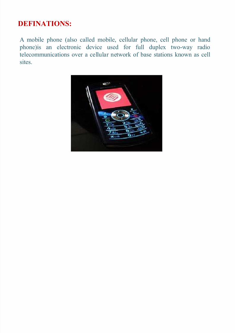
DEFINATIONS:
A mobile phone (also called mobile, cellular phone, cell phone or hand phone)is an electr onic device used f or full duplex two-way radio
telecommunications over a cellular network of base stations known as cell
sites.
8/6/2019 Tejashwini S.G Main-presentation
http://slidepdf.com/reader/full/tejashwini-sg-main-presentation 4/33
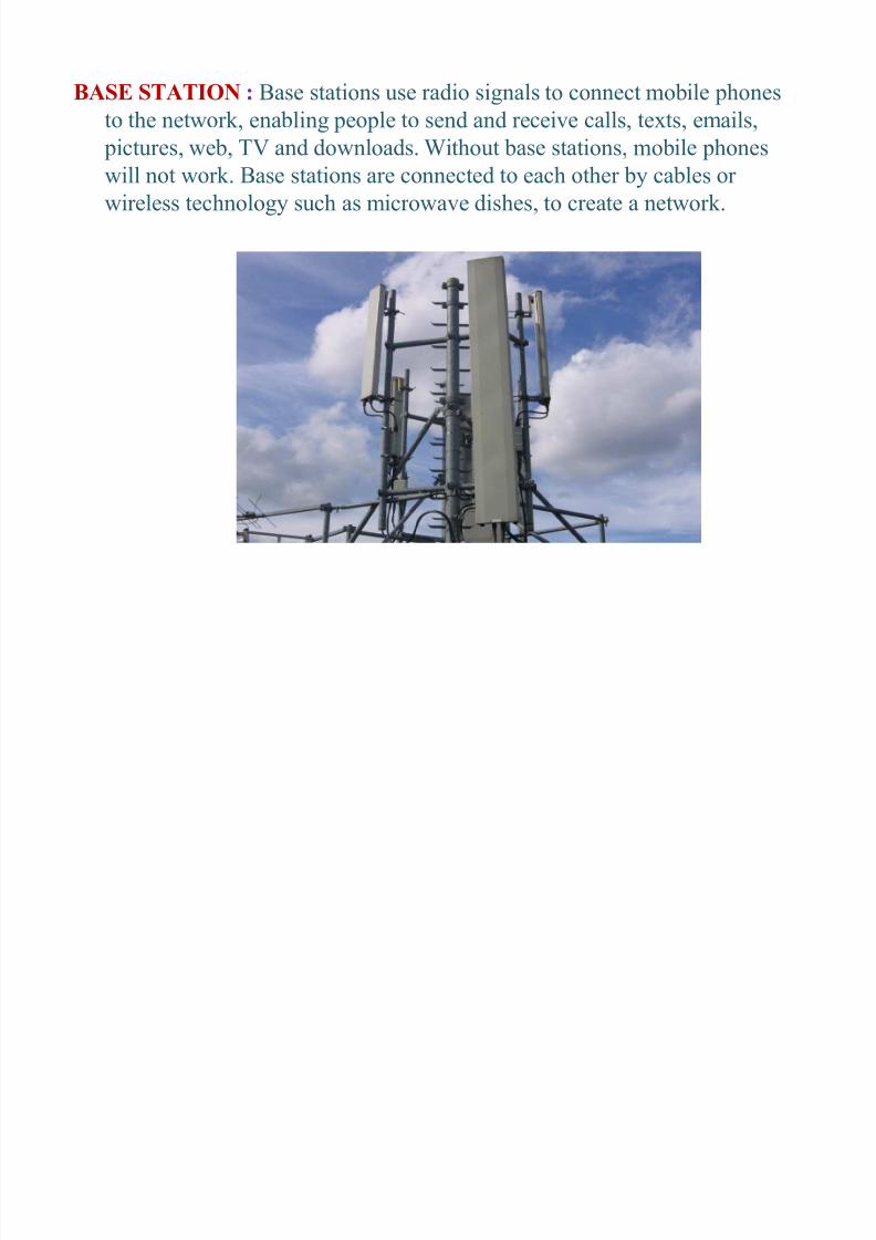
BASE STATION : Base stations use radio signals to connect mobile phones
to the network, ena bling peo ple to send and receive calls, texts, emails,
pictures, we b, TV and downloads. Without base stations, mobile phoneswill not work. Base stations are connected to each other by ca bles or
wireless technology such as micr owave dishes, to create a network.
8/6/2019 Tejashwini S.G Main-presentation
http://slidepdf.com/reader/full/tejashwini-sg-main-presentation 5/33
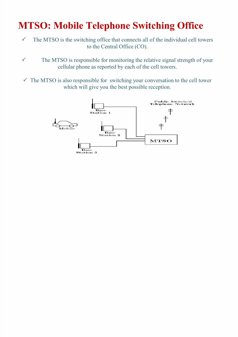
MTSO: Mobile Telephone Switching Office
The MTSO is
the swi
tching
offi
ce
tha
t co
nnect
s allo
f the individual
cell
towers
to the Central Office (CO).
The MTSO is responsi ble f or monitoring the relative signal strength of your
cellular phone as repor ted by each of the cell towers.
The MTSO is als
o
respo
nsi b
le f o
r switc
hing yo
ur co
nversat
io
nto
t
hec
ellto
wer which will give you the best possi ble reception.
8/6/2019 Tejashwini S.G Main-presentation
http://slidepdf.com/reader/full/tejashwini-sg-main-presentation 6/33
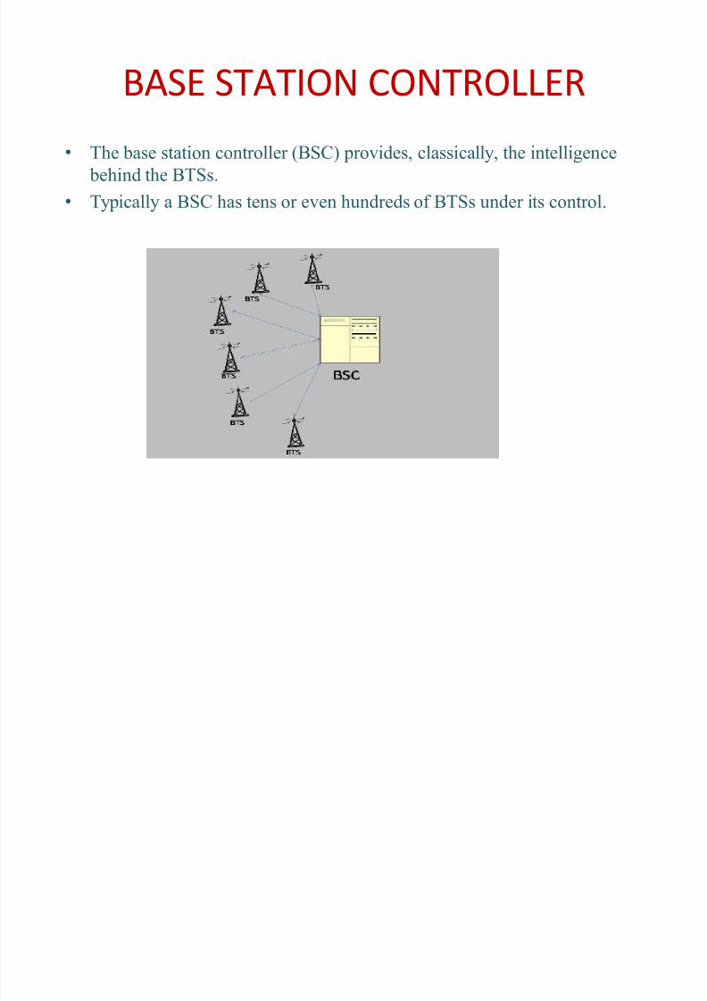
BASE STATION CONTROLLER
� The base station contr oller (BSC) pr ovides, classically, the intelligence
behind the BTSs.
� Typically a BSC has tens or even hundreds of BTSs under its contr ol.
8/6/2019 Tejashwini S.G Main-presentation
http://slidepdf.com/reader/full/tejashwini-sg-main-presentation 7/33
ESN AND MIN: An electr onic serial number (ESN) is the unique
identification number embedded or inscri bed on the micr ochip in awireless phone by the manufacturer.
� Each time a call is placed, the ESN is automatically transmitted to
the base station so the wireless carrier's mobile switching office cancheck the call's validity.
� The ESN cannot easily be altered in the field. The ESN differs fr om
the mobile identification number (MIN), which is the wirelesscarrier's identifier f or a p hone in the network.
� MINs and ESNs can be electr onically checked to help prevent fraud.
Public Safety Answering Point (PSAP): The final destination of anE911 call (where the 911 o perator sits) is a Pu blic Safety AnsweringPoint (PSAP).
8/6/2019 Tejashwini S.G Main-presentation
http://slidepdf.com/reader/full/tejashwini-sg-main-presentation 8/33
R EVIEW TO MOBILE TECHNOLOGY
Mobile positioning technology has become an im por tant area of resear ch, f or
emergency as well as f or commer cial services.
Mobile positioning in cellular networks will pr ovide several services such as,
locating stolen mobiles, emergency calls, different billing tariffs depending on
where the call is originated, and methods to predict the user movement insidea region.
The major challenge to accurate location estimation is in creating techniques
that yield accepta ble perf or mance when the direct path fr om the transmitter to
the receiver is inter mittently blocked. This is the Non-Line-Of -Sight (NLOS)
pr ob
lem
, and it
is known
to be a
maj
or s
our
ce
of err
or sin
ce i
tsys
te
ma
tically
causes mobile to appear far ther away fr om the base station (BS) than it
actually is, there by increasing the positioning err or.
8/6/2019 Tejashwini S.G Main-presentation
http://slidepdf.com/reader/full/tejashwini-sg-main-presentation 9/33
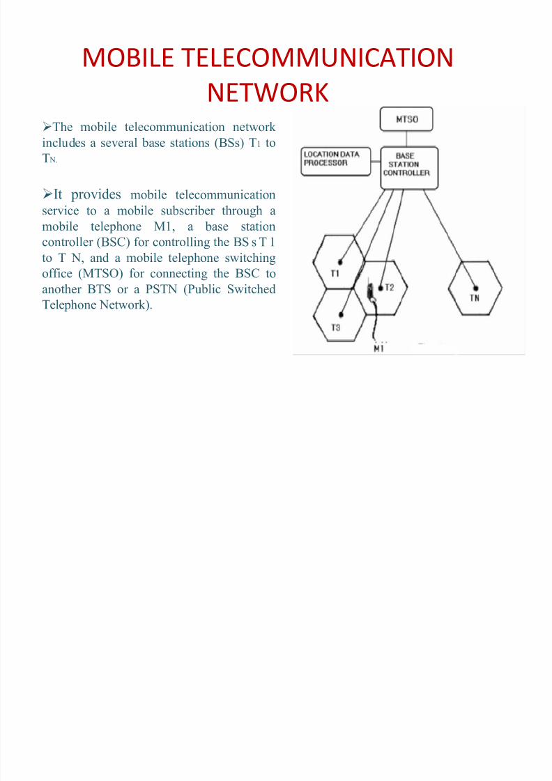
MOBILE TELECOMMUNICATION
NETWORKThe mobile telecommunication network
includes a several base stations (BSs) T1 to
T N.
It pr ovides mobile telecommunicationservice to a mobile su bscri ber thr ough a
mobile telephone M1, a base station
contr oller (BSC) f or contr olling the BS s T 1
to T N, and a mobile telephone switching
office (MTSO) f or connecting the BSC to
another BTS or a PSTN (Pu blic SwitchedTelephone Network).
8/6/2019 Tejashwini S.G Main-presentation
http://slidepdf.com/reader/full/tejashwini-sg-main-presentation 10/33
Each BS is pr ovided with a frequency of a range between 450 to900
MHz
More than one cells can use same frequency.
Only condition is that no two adjacent cells must have same frequencies.
MTSO contr ols these BSs so that a su bscri ber can continue his callwithout interruption while moving between different cells.
8/6/2019 Tejashwini S.G Main-presentation
http://slidepdf.com/reader/full/tejashwini-sg-main-presentation 11/33
NEED FOR TR ACKING
1. All the BSs are sending a signal of power 25 to 30w to the mobile unit.
When a user switches ON his mobile, it will sear ch f or the str ongest signal
and got connected to that BS. Then the mobile unit sends an identification
signal to the BS. When he fixes a call, the BS accepts the request and sends
the request to the BSC and MTSO. Then the MTSO will sear ches wherethe su bscri ber is and connects the call.
2. When a user moves to another cell the MTSO will change the frequency
allotted to it and allots the frequency of the new BS. For both these
pr ocesses GEOLOCATION of the mobile unit is essential.
3.R
ecen
tde
mands fr
omnew appli
ca
tions require p
osi
tioning
capa
bili
ties
of mobile telephones or other devices. The a bility to obtain the geo-location
of the Mobile Telephone (MT) in the cellular system allows the network
o perators to facilitate new services to the mobile users.
8/6/2019 Tejashwini S.G Main-presentation
http://slidepdf.com/reader/full/tejashwini-sg-main-presentation 12/33
4. Themo
st
imm
ediat
emot
ivat
io
n f o
r t
hec
ellular syst
em to
pr o
videMT position is enhanced in accident emergency services. The geo-
location of the mobile user could pr ovide services like :
Emergency service f or su bscri ber safety.
Location sensitive billing.
Cellular Fraud detection.
Intelligent transpor t system services.
Efficient and effective network perf or mance and management.
8/6/2019 Tejashwini S.G Main-presentation
http://slidepdf.com/reader/full/tejashwini-sg-main-presentation 13/33
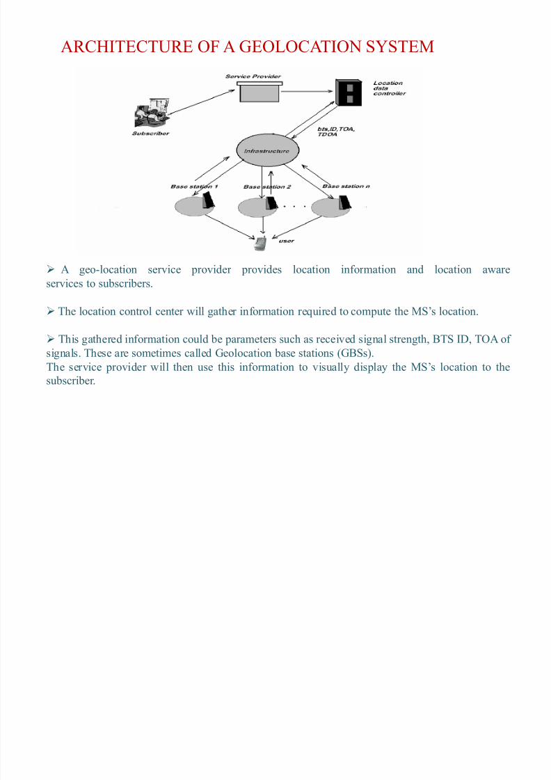
AR CHITECTUR E OF A GEOLOCATION SYSTEM
A geo-location service pr ovider pr ovides location inf or mation and location aware
servic
esto
su b
sc
ri b
ers.
The location contr ol center will gather inf or mation required to com pute the MS¶s location.
This gathered inf or mation could be parameters such as received signal strength, BTS ID, TOA of
signals. These are sometimes called Geolocation base stations (GBSs).
The service pr ovider will then use this inf or mation to visually display the MS¶s location to the
su b
scri
ber.
8/6/2019 Tejashwini S.G Main-presentation
http://slidepdf.com/reader/full/tejashwini-sg-main-presentation 14/33
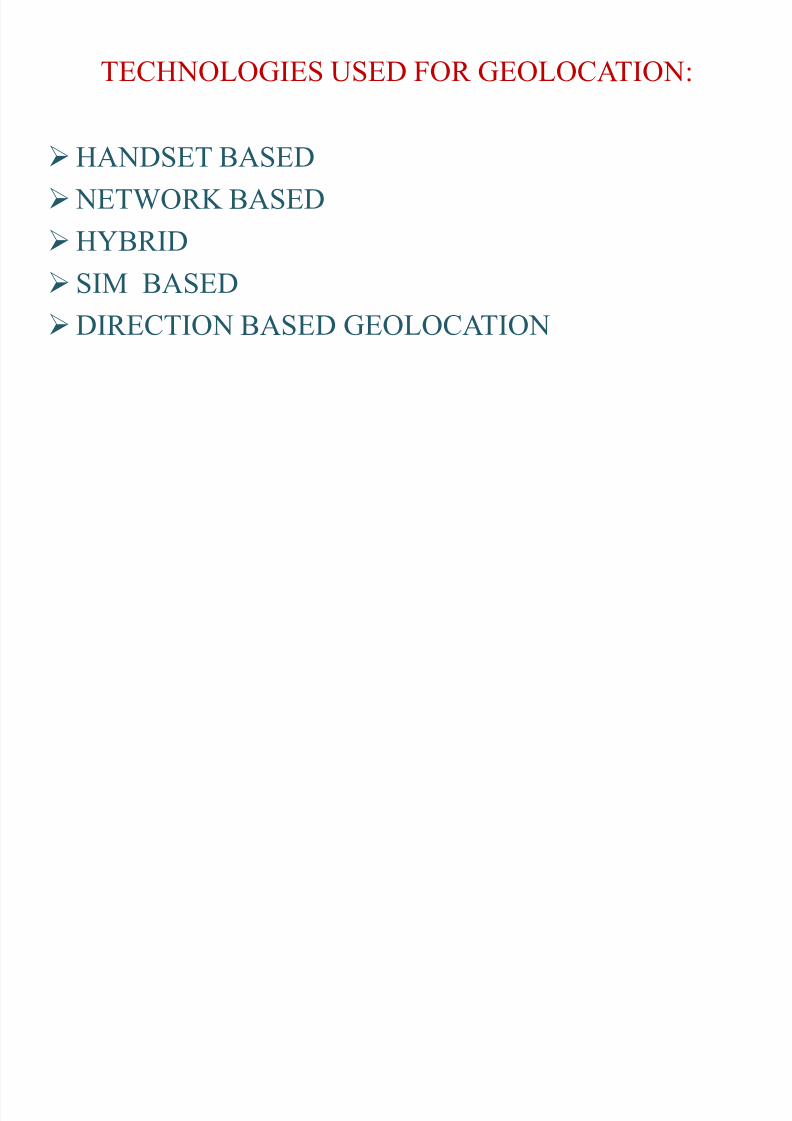
TECHNOLOGIES USED FOR GEOLOCATION:
HA NDSET BASED
NETWOR K BASED
HYBR ID
SIM BASED
DIR ECTION BASED GEOLOCATION
8/6/2019 Tejashwini S.G Main-presentation
http://slidepdf.com/reader/full/tejashwini-sg-main-presentation 15/33
HA NDSET BASED
� It requires installation of Client Sof tware on the handset to deter mine its location.� This technique deter mines the location of the handset by com puting its location by
cell identification, signal strengths of the home and neigh boring cells, which iscontinuously sent to the carrier.
� In addition, if the handset is also equipped with GPS then significantly more preciselocation inf or mation is then sent fr om the handset to the carrier.
ADVA NTAGES:� It accurately deter mines the position.
DISADVA NTAGES:
� The key disadvantage of this technique (fr om mobile o perator's point of view) is thenecessity of installing sof tware on the handset .
� Increases the price and the size of the mobile telephone.� The load on the mobile telephone is increased.
� Power consum ption is high.
8/6/2019 Tejashwini S.G Main-presentation
http://slidepdf.com/reader/full/tejashwini-sg-main-presentation 16/33
NETWORK BASED:
GSM cell phones' technology works based on small, equal, and adjacent areas. Each area is ter med a "cell". An entire region covered by a service pr ovider contains several such cells.
Network -based techniques utilize the service pr ovider's network infrastructure to identify the location of the handset
The accuracy of network -based techniques varies, with cell identificationas the least accurate and triangulation as the most accurate.
The accuracy of network -based techniques is closely dependent on theconcentration of base station cells, with ur ban envir onments achievingthe highest possi ble accuracy.
ADVA NTAGES:
The advantage of network -based techniques (fr om mobile o perator's point of view) is that
they can be im plemented non-intrusively, without affecting the handsets.
As the installation of hardware and sof tware is within the o perator's infrastructure the
price of the handset is reduced.
8/6/2019 Tejashwini S.G Main-presentation
http://slidepdf.com/reader/full/tejashwini-sg-main-presentation 17/33
Hy
brid p
osi
tioning sys
te
ms are sys
te
ms f
or finding
the l
oca
tio
no
f amob
iledevice using several different positioning technologies. Usually GPS (Global
Positioning System) is one major com ponent of such systems, combined with cell
tower signals, wireless internet signals, Bluetooth sensors or other local
Positioning Systems.
These systems are specifically designed to over come the limitations of GPS,
which is very exa
ctin
o pen areas,
bu
tw
orks p
oorly ind
oors
or
be
tween
tall
buildings
Skyhook¶s Core Engine is a sof tware-only location system that quickly
deter mines device location with 10 to 20 meter accuracy. It is presently
im plemented in USA .
SIM BASED :
Using SIM in GSM and UMTS (Universal Mobile Telecommunication
System)handsets, it is possi ble to obtain raw radio measurements fr om the
handset.
Measurements can include serving Cell-ID, r ound-trip time and signal strength.
Type 0f inf or mation obtained via SIM can differ fr om what is availa ble fr om thehandset.
HYBR ID :
8/6/2019 Tejashwini S.G Main-presentation
http://slidepdf.com/reader/full/tejashwini-sg-main-presentation 18/33
DIR ECTION BASED GEOLOCATION
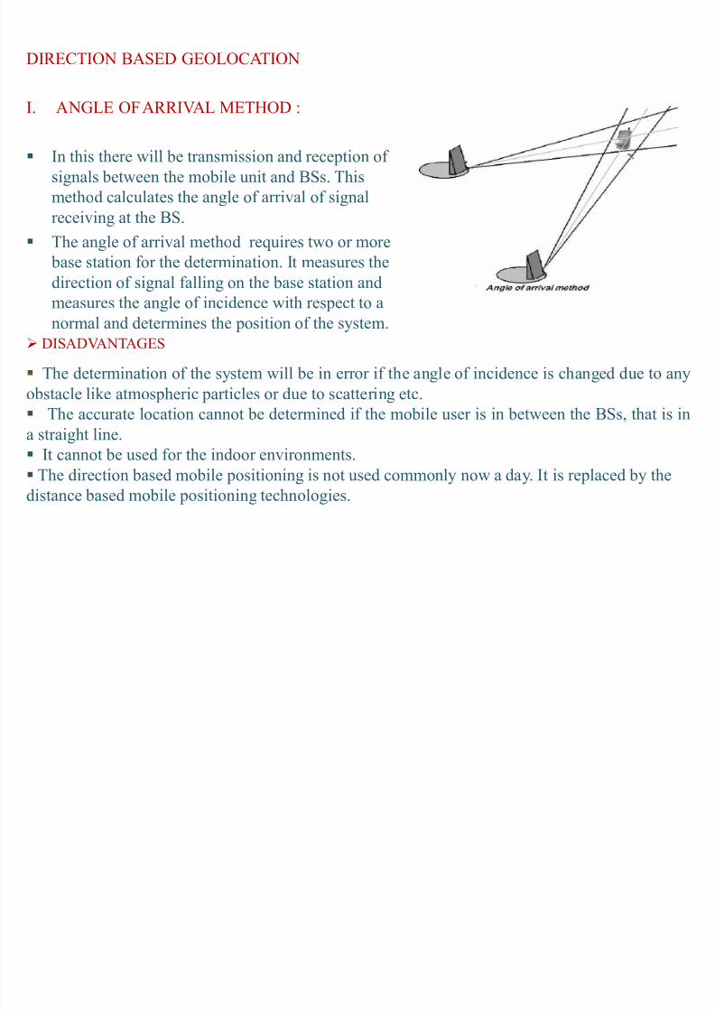
I. A NGLE OF ARR IVAL METHOD :
In this there will be transmission and reception of
signals between the mobile unit and BSs. This
method calculates the angle of arrival of signal
receiving at the BS.
The angle of arrival method requires two or more
base station f or the deter mination. It measures the
direction of signal falling on the base station and
measures the angle of incidence with respect to a
nor mal and deter mines the position of the system. DISADVA NTAGES
The deter mination of the system will be in err or if the angle of incidence is changed due to anyobstacle like atmospheric par ticles or due to scattering etc.
The accurate location cannot be deter mined if the mobile user is in between the BSs, that is in
a straight line.
It cannot be used f or the indoor envir onments.
The direction based mobile positioning is not used commonly now a day. It is replaced by the
distan
ce
based
mobile p
osi
tio
ningte
chn
olo
gies.
8/6/2019 Tejashwini S.G Main-presentation
http://slidepdf.com/reader/full/tejashwini-sg-main-presentation 19/33
DISTANCE BASED POSITIONING
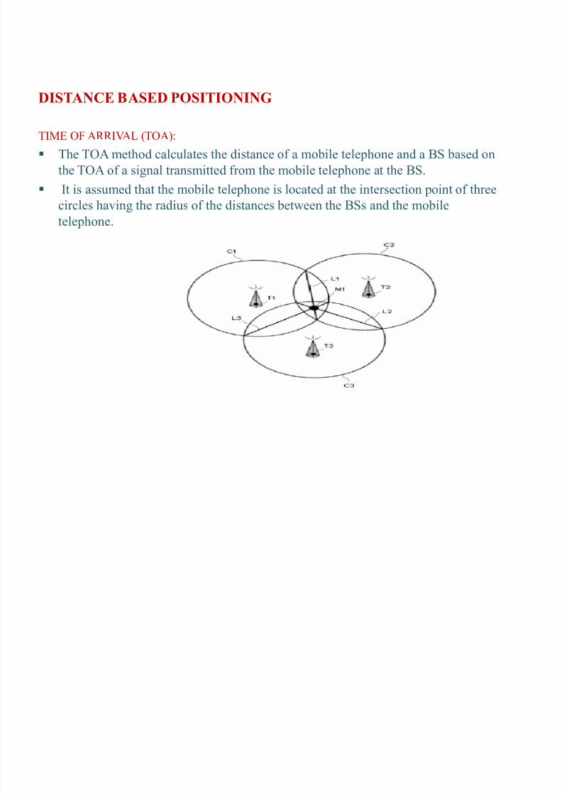
TIME OF ARR IVAL (TOA):
The TOA method calculates the distance of a mobile telephone and a BS based on
the TOA of a signal transmitted fr om the mobile telephone at the BS.
It is assumed that the mobile telephone is located at the intersection point of three
cir cles having the radius of the distances between the BSs and the mobile
telephone.
8/6/2019 Tejashwini S.G Main-presentation
http://slidepdf.com/reader/full/tejashwini-sg-main-presentation 20/33
.
�Three cir cles C1, C2, and C3, whose radii are the distance between the mobile telephone
M1 and at least three BSs T1, T2, and T3, are overlapped acr oss an area. The mobile
telephone M1 is located in the overlap area.
�When at least three cir cles C1, C2, and C3 are overlapped over an area without meeting
at one point, the mobile telephone M1 is considered to exist at the intersection point of
three common chords L1, L2, and L3.
The a bove method using the common chord is not very accurate in locating the mobile
telephone except in the case where the mobile telephone is at an appr oximate equal
distance fr om the selected BSs and in a similar pr o pagation envir onment to each
respective BS
8/6/2019 Tejashwini S.G Main-presentation
http://slidepdf.com/reader/full/tejashwini-sg-main-presentation 21/33
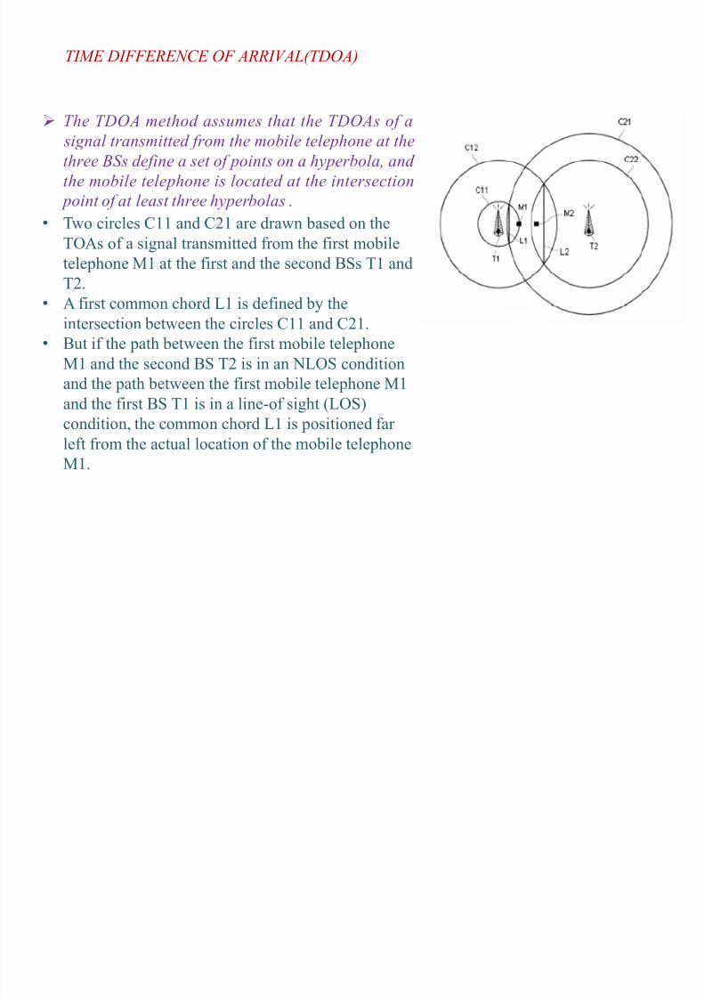
� Two cir cles C11 and C21 are drawn based on the
TOAs of a signal transmitted fr om the first mobiletelephone M1 at the first and the second BSs T1 and
T2.
� A first common chord L1 is defined by the
intersection between the cir cles C11 and C21.
� But if the path between the first mobile telephone
M1 andthe se
cond
B
S T2 is in an NLOSco
nditionand the path between the first mobile telephone M1
and the first BS T1 is in a line-of sight (LOS)
condition, the common chord L1 is positioned far
lef t fr om the actual location of the mobile telephone
M1.
The TDOA method assumes that the TDOAs of a signal transmitted from the mobile telephone at the
three BSs define a set of points on a hyperbola, and
the mobile telephone is located at the intersection
point of at least three hyperbolas .
TIME DIFFERENCE OF ARRIVAL(TDOA)
8/6/2019 Tejashwini S.G Main-presentation
http://slidepdf.com/reader/full/tejashwini-sg-main-presentation 22/33
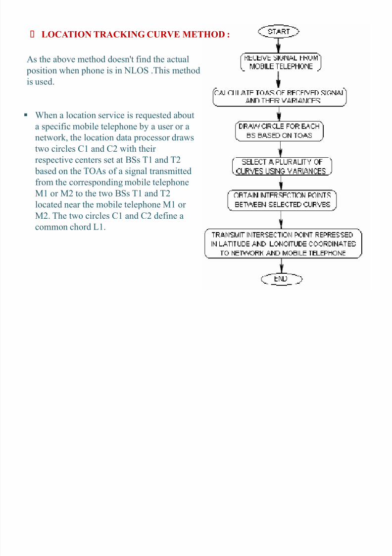
When a location service is requested a bout
a specific mobile telephone by a user or a
network, the location data pr ocessor drawstwo cir cles C1 and C2 with their
respective centers set at BSs T1 and T2
based on the TOAs of a signal transmitted
fr om the corresponding mobile telephone
M1 or M2 to the two BSs T1 and T2
located near the mobile telephone M1 or M2. The two cir cles C1 and C2 define a
common chord L1.
LOCATION TRACKING CURVE METHOD :
As the a bove method doesn't find the actual
position when phone is in NLOS .This methodis used.
8/6/2019 Tejashwini S.G Main-presentation
http://slidepdf.com/reader/full/tejashwini-sg-main-presentation 23/33
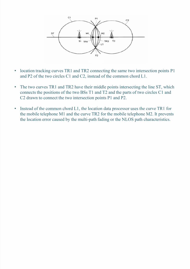
� location tracking curves TR 1 and TR 2 connecting the same two intersection points P1
and P2 of the two cir cles C1 and C2, instead of the common chord L1.
� The two curves TR 1 and TR 2 have their middle points intersecting the line ST, which
connects the positions of the two BSs T1 and T2 and the par ts of two cir cles C1 and
C2 drawn to connect the two intersection points P1 and P2.
� Instead of the common chord L1, the location data pr ocessor uses the curve TR 1 f or
the mobile telephone M1 and the curve TR 2 f or the mobile telephone M2. It prevents
the location err or caused by the multi- path fading or the NLOS path characteristics.

8/6/2019 Tejashwini S.G Main-presentation
http://slidepdf.com/reader/full/tejashwini-sg-main-presentation 24/33
APPLICATIONS:
1. Em
ergenc
y servic
e f o
r su b
sc
ri b
er safet
y.2. Location based services.
3. Cellular Fraud detection.
4. Intelligent transpor t system services.
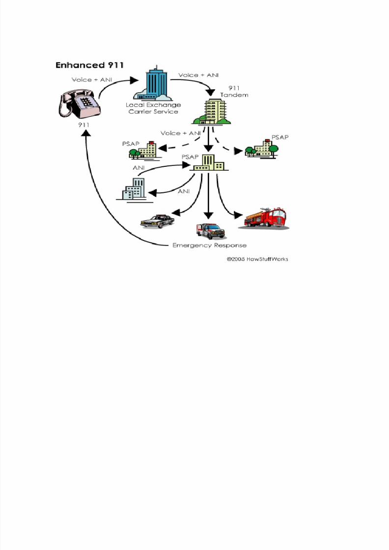
ENHANCED 911:
In America, call 911 when there's an emergency. When 911is dialed , the -call is
automatically f orwarded to a pu blic-safety answering point (PSAP), also called a
911 call center. Today, many areas also have Enhanced 911 (E-911), which allows a
PSAP to deter mine the general location fr om where the call originated, but cannot
yet pinpoint the location.
8/6/2019 Tejashwini S.G Main-presentation
http://slidepdf.com/reader/full/tejashwini-sg-main-presentation 25/33
8/6/2019 Tejashwini S.G Main-presentation
http://slidepdf.com/reader/full/tejashwini-sg-main-presentation 26/33
� Location inf or mation must be accurate within 164 to 984 feet (50-300 meters). a cell-
phone user's phone number, or Automatic Number Identification (A NI), and the address
and location of the receiving-antenna site will be sent to the E-911 Tandem, the switch
that r outes 911 calls to the appr o priate PSAP based on the A NI-defined geographic
location.
�Once the caller's voice and A NI are transferred to the PSAP, the PSAP o perator will be
a ble to view a graphic display that shows the longitude and latitude of the person as
accessed thr ough GPS satellites.
�The o perator's com puter will link to the ALI data base, which stores address data andother inf or mation.
�The caller's address and inf or mation is displayed to the call taker immediately upon call
arrival.
�This pr ovides e
mergen
cy resp
onders wi
th
the l
oca
tio
no
f the e
mergen
cy wi
th
ou
t the person calling f or help having to pr ovide it.
�This is of ten useful in times of fires, break -ins, kidnapping, and other events where
communicating one's location is difficult or im possi ble.
� The final phase requires carriers to place GPS receivers in phones in order to deliver
more specific latitude and longitude location inf or mation.
8/6/2019 Tejashwini S.G Main-presentation
http://slidepdf.com/reader/full/tejashwini-sg-main-presentation 27/33
LOCATION BASED SER VICES:
A location-based service (LBS) is an inf or mation and enter tainment service,
accessi ble with mobile devices thr ough the mobile network and utilizing the a bility
to make use of the geographical position of the mobile device .Some exam ples of location-based services are:
� R equesting the nearest business or service, such as an ATM or restaurant
� Turn by turn navigation to any address
� Locating peo ple on a map displayed on the mobile phone
� R eceiving aler ts, such as notification of a sale on gas or warning of a traffic jam� Location-based mobile adver tising.
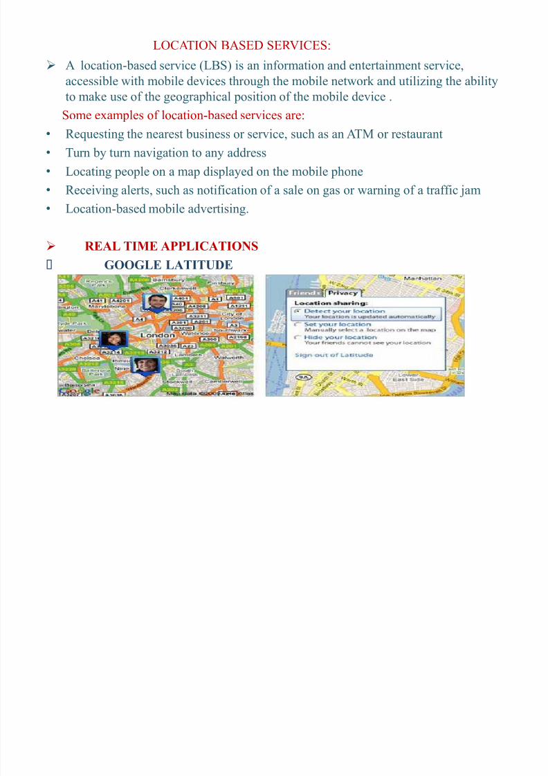
REAL TIME APPLICATIONS
GOOGLE LATITUDE
8/6/2019 Tejashwini S.G Main-presentation
http://slidepdf.com/reader/full/tejashwini-sg-main-presentation 28/33
Google Latitude a feature intr oduced on Google Maps in 2009 that can be accessed on
both mobile phones and PCs, f or exam ple. It lets you share your location and see
where your friends and family are on a digital map.
In India, two o perators Bhar ti and Hutch(presently Vodaf one)have intr oduced location-
based services of different kinds.
Hutch¶s location-based service launched in Delhi and NCR is called 'Hutch4help'.
Hutch has offered this service to all its su bscri bers including the prepaid and the
post- paid card holders owning any brand of handset and SIM card memory of any
level. Hutch service is a dial-in location based service. Hutch pr ovides police,chemist, hospital and taxi service on Hutch4help.
Bhar ti gr oup calls its location based services as 'Ar ound-me' which is o perational in
Mumbai and Delhi.
Air tel service is data (SMS) based. Bhar ti offers services like sho pping (clothes,
electr onics, gif ts, interior etc.) with discounts, restaurant, enter tainment (discos,
pu bs etc.), utilities(taxis, banks, ATMs, travel agents, car servicing centres ,
petr ol pum p, car dealers), medical (chemists, hospitals and doctors) and hotels (5/3
star, budget). The user has to press clothes in the sho pping menu while person is
ar ound a cer tain area and he gets an SMS with details of sho p names, addresses,
and phone numbers within 10 k m radius.
8/6/2019 Tejashwini S.G Main-presentation
http://slidepdf.com/reader/full/tejashwini-sg-main-presentation 29/33
8/6/2019 Tejashwini S.G Main-presentation
http://slidepdf.com/reader/full/tejashwini-sg-main-presentation 30/33
REFERENCES
J. Caffery , and G. Stu ber Jr, ³Vehicle location and tracking f or
IVHS in CDMA micr o-cells´, Pr oc. IEEE P IMRC , 1994
G. Morley, and W. Gr over, ³Im pr oved location estimation with
pulse-ranging in presence of shadowing and multi- path
excess-delay effects´, Electr onics Letters, vol.31, No.18, 1995
www.ieeexpl
ore.ieee.
org
gp.espacenet.com
8/6/2019 Tejashwini S.G Main-presentation
http://slidepdf.com/reader/full/tejashwini-sg-main-presentation 31/33
CONCLUSION
Hence it can be concluded that the tracking and deter mining the position
of mobile phone accurately is im por tant even in the multi- path fading
and the NLOS envir onment.
Accurate positioning of mobile telephones, which can be used f or
several applications.
Theimportant consid
erations to b
eund
ertak
en w
hile
selecting a location bas
edtechnology ar e location accuracy, implementation cost, r eliability, incr easing functionality.

8/6/2019 Tejashwini S.G Main-presentation
http://slidepdf.com/reader/full/tejashwini-sg-main-presentation 32/33
THANK YOU...!!

8/6/2019 Tejashwini S.G Main-presentation
http://slidepdf.com/reader/full/tejashwini-sg-main-presentation 33/33
A NY
QUESTIONS?