bienvenido / welcome rural turismo - …pinohuacho.cl/descargas/mapa-pinohuacho.pdf · villarrica,...
TRANSCRIPT
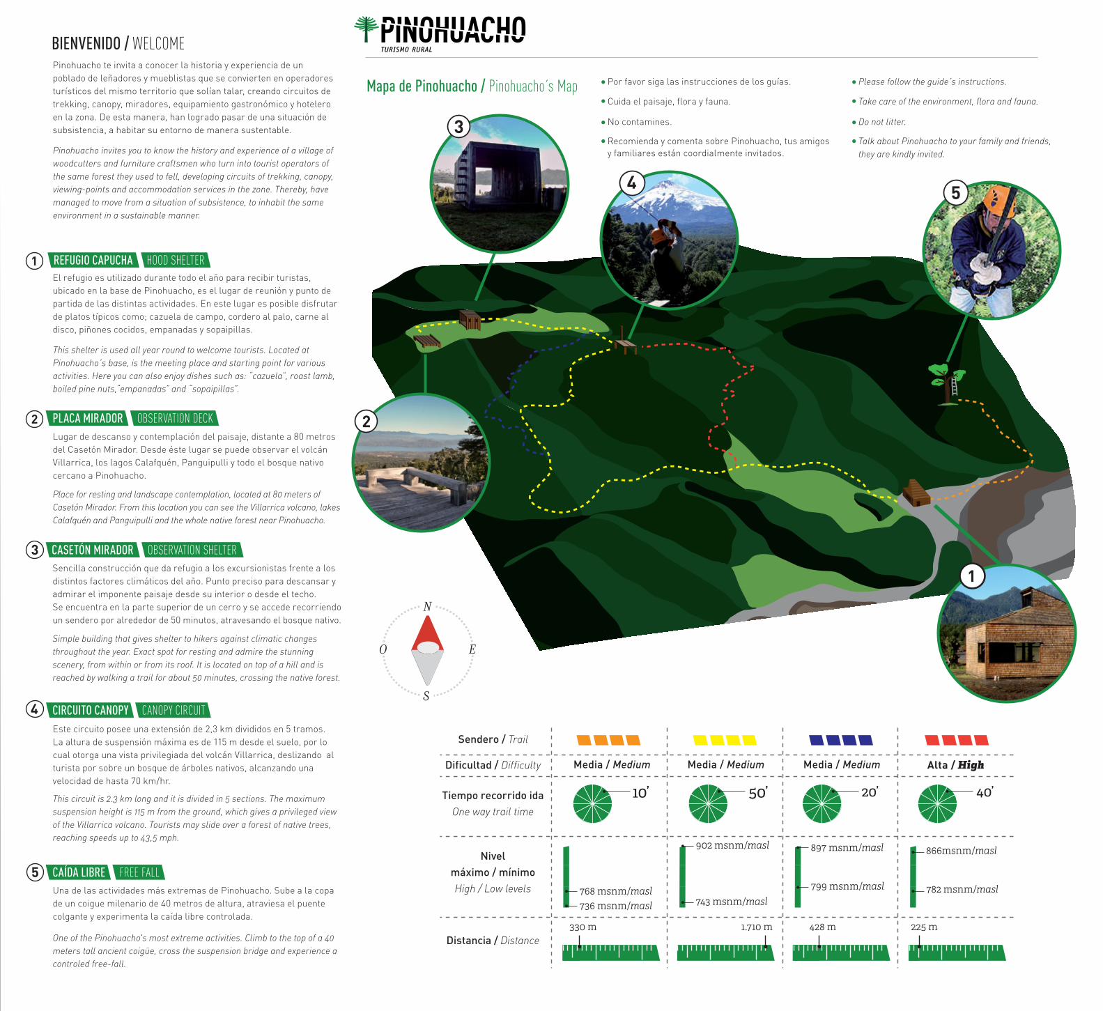
BIENVENIDO / WELCOME
Mapa de Pinohuacho / Pinohuacho s Map
Pinohuacho te invita a conocer la historia y experiencia de un poblado de leñadores y mueblistas que se convierten en operadores turísticos del mismo territorio que solían talar, creando circuitos de trekking, canopy, miradores, equipamiento gastronómico y hotelero en la zona. De esta manera, han logrado pasar de una situación de subsistencia, a habitar su entorno de manera sustentable.
Pinohuacho invites you to know the history and experience of a village of woodcutters and furniture craftsmen who turn into tourist operators of the same forest they used to fell, developing circuits of trekking, canopy, viewing-points and accommodation services in the zone. Thereby, have managed to move from a situation of subsistence, to inhabit the same environment in a sustainable manner.
Por favor siga las instrucciones de los guías.
Cuida el paisaje, flora y fauna.
No contamines.
Recomienda y comenta sobre Pinohuacho, tus amigos y familiares están coordialmente invitados.
Sencilla construcción que da refugio a los excursionistas frente a los distintos factores climáticos del año. Punto preciso para descansar y admirar el imponente paisaje desde su interior o desde el techo. Se encuentra en la parte superior de un cerro y se accede recorriendo un sendero por alrededor de 50 minutos, atravesando el bosque nativo.
Simple building that gives shelter to hikers against climatic changes throughout the year. Exact spot for resting and admire the stunning scenery, from within or from its roof. It is located on top of a hill and is reached by walking a trail for about 50 minutes, crossing the native forest.
CASETÓN MIRADOR OBSERVATION SHELTER
PLACA MIRADOR OBSERVATION DECKLugar de descanso y contemplación del paisaje, distante a 80 metros del Casetón Mirador. Desde éste lugar se puede observar el volcán Villarrica, los lagos Calafquén, Panguipulli y todo el bosque nativo cercano a Pinohuacho.
Place for resting and landscape contemplation, located at 80 meters of Casetón Mirador. From this location you can see the Villarrica volcano, lakes Calafquén and Panguipulli and the whole native forest near Pinohuacho.
Este circuito posee una extensión de 2,3 km divididos en 5 tramos. La altura de suspensión máxima es de 115 m desde el suelo, por lo cual otorga una vista privilegiada del volcán Villarrica, deslizando al turista por sobre un bosque de árboles nativos, alcanzando una velocidad de hasta 70 km/hr.
This circuit is 2.3 km long and it is divided in 5 sections. The maximum suspension height is 115 m from the ground, which gives a privileged view of the Villarrica volcano. Tourists may slide over a forest of native trees, reaching speeds up to 43,5 mph.
CIRCUITO CANOPY CANOPY CIRCUIT
This shelter is used all year round to welcome tourists. Located at Pinohuacho s base, is the meeting place and starting point for various activities. Here you can also enjoy dishes such as: “cazuela”, roast lamb, boiled pine nuts,“empanadas” and “sopaipillas”.
El refugio es utilizado durante todo el año para recibir turistas, ubicado en la base de Pinohuacho, es el lugar de reunión y punto de partida de las distintas actividades. En este lugar es posible disfrutar de platos típicos como; cazuela de campo, cordero al palo, carne al disco, piñones cocidos, empanadas y sopaipillas.
REFUGIO CAPUCHA HOOD SHELTER
TURISMO RURAL
Please follow the guide s instructions.
Take care of the environment, flora and fauna.
Do not litter.
Talk about Pinohuacho to your family and friends, they are kindly invited.
Una de las actividades más extremas de Pinohuacho. Sube a la copa de un coigue milenario de 40 metros de altura, atraviesa el puente colgante y experimenta la caída libre controlada.
One of the Pinohuacho's most extreme activities. Climb to the top of a 40 meters tall ancient coigüe, cross the suspension bridge and experience a controled free-fall.
CAÍDA LIBRE FREE FALL
Tiempo recorrido idaOne way trail time
Nivel máximo / mínimoHigh / Low levels
Distancia / Distance
Dificultad / Difficulty Alta / HighMedia / Medium Media / Medium Media / Medium
Sendero / Trail
768 msnm/masl736 msnm/masl
902 msnm/masl
743 msnm/masl
897 msnm/masl
799 msnm/masl
866msnm/masl
782 msnm/masl
1.710 m 330 m 225 m 428 m
10’ 50’
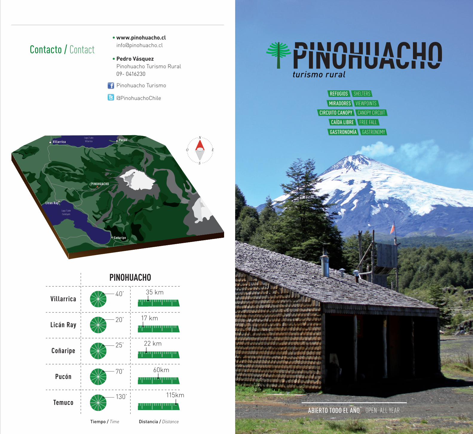
Contacto / ContactPedro Vásquez Pinohuacho Turismo Rural09- 0416230
Pinohuacho Turismo
@PinohuachoChile
Villarrica
PINOHUACHO
Lago / Lake Villarrica
Lago / Lake Calafquén
Pucón
Coñaripe
Lican Ray
PINOHUACHO 35 km40’
17 km20’
22 km25’
60km70’
115km130’
Villarrica
Licán Ray
Coñaripe
Pucón
Temuco
Tiempo / Time Distancia / Distance
MIRADORES VIEWPOINTS
GASTRONOMÍA GASTRONOMY
CIRCUITO CANOPY CANOPY CIRCUIT
REFUGIOS SHELTERS
CAÍDA LIBRE FREE FALL
ABIERTO TODO EL AÑO OPEN ALL YEAR
turismo rural