aran wiener portfolio
DESCRIPTION
Select work from the past few years.TRANSCRIPT
vv`
Aran Wiener Design Portfolio


MASTER PLANNING TOWN PLANNINGLANDSCAPE ARCHITECTURE ENV. CONSULTING
Jalan JalanSetapak
Sungai Subak
.5 KM 1 KM
KAJA
UTARA
Sudajiv
Aran Wiener 2010 [email protected]
Sudaji
denpaSSarubud
Kintamani
bedugul
Singaraja
COMMUNITY DEVELOPMENT COMPLETED WORK
04-07 08-09 10-12 13 14-15 16
44
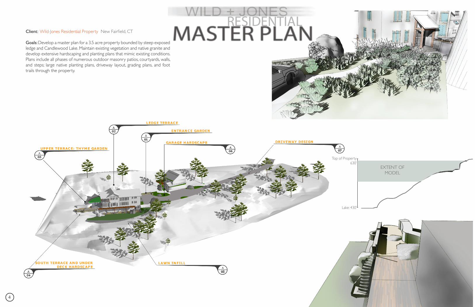
Client: Wild-Jones Residential Property New Fairfield, CT
Goals: Develop a master plan for a 3.5 acre property bounded by steep exposed ledge and Candlewood Lake. Maintain existing vegetation and native granite and develop extensive hardscaping and planting plans that mimic existing conditions. Plans include all phases of numerous outdoor masonry patios, courtyards, walls, and steps; large native planting plans, driveway layout, grading plans, and foot trails through the property.
Lake: 430’
Top of Property630’
EXTENT OF MODEL
5Aran Wiener
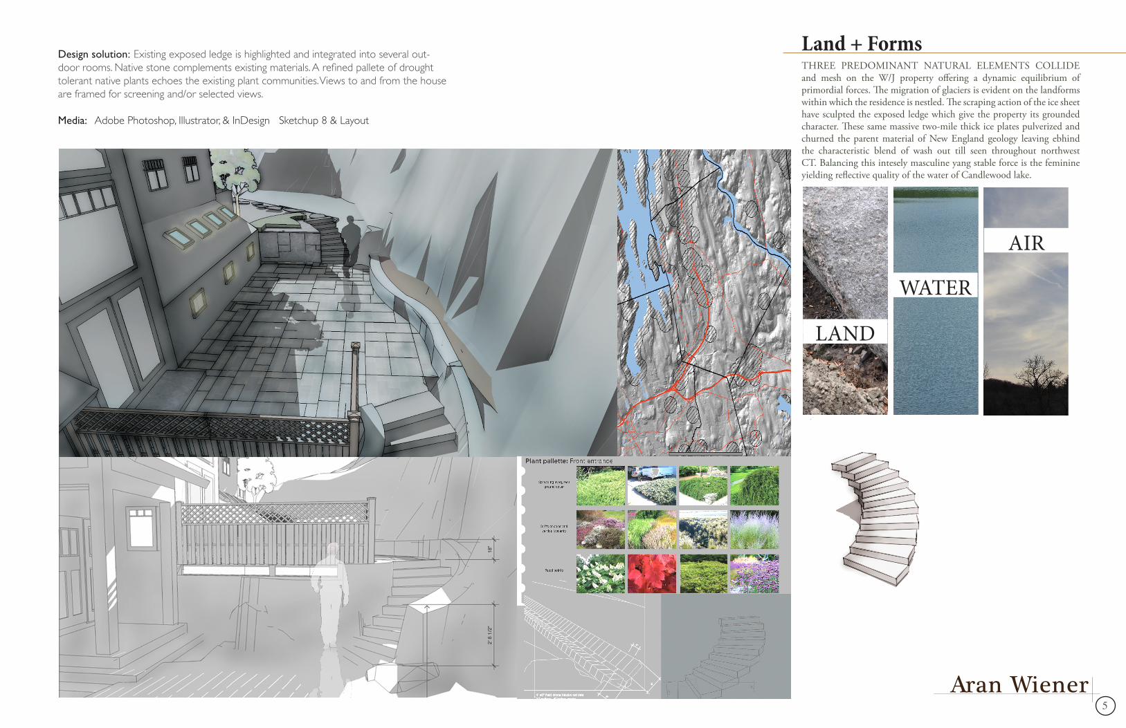
Design solution: Existing exposed ledge is highlighted and integrated into several out-door rooms. Native stone complements existing materials. A refined pallete of drought tolerant native plants echoes the existing plant communities. Views to and from the house are framed for screening and/or selected views.
Media: Adobe Photoshop, Illustrator, & InDesign Sketchup 8 & Layout
Land + FormsTHREE PREDOMINANT NATURAL ELEMENTS COLLIDE and mesh on the W/J property offering a dynamic equilibrium of primordial forces. The migration of glaciers is evident on the landforms within which the residence is nestled. The scraping action of the ice sheet have sculpted the exposed ledge which give the property its grounded character. These same massive two-mile thick ice plates pulverized and churned the parent material of New England geology leaving ebhind the characteristic blend of wash out till seen throughout northwest CT. Balancing this intesely masculine yang stable force is the feminine yielding reflective quality of the water of Candlewood lake.
LAND
WATER
AIR
66
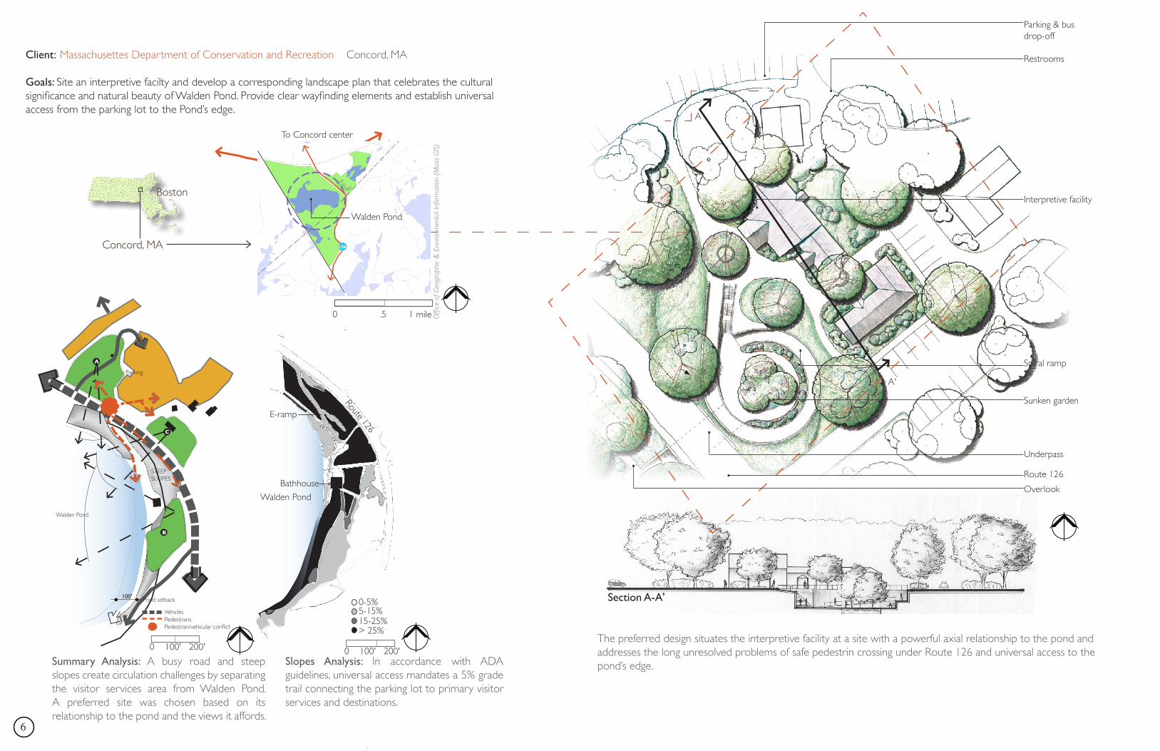
Client: Massachusettes Department of Conservation and Recreation Concord, MA
Goals: Site an interpretive facilty and develop a corresponding landscape plan that celebrates the cultural significance and natural beauty of Walden Pond. Provide clear wayfinding elements and establish universal access from the parking lot to the Pond’s edge.
A
Restrooms
Parking & bus drop-off
Route 126
Underpass
Overlook
Interpretive facility
Spiral ramp
Sunken garden
Conco
rdLin
coln
boun
dary
(app
rox.)
2
To Concord center
Section A-A'
A'
0 .5 1 mile
Route 126
Walden Pond
E-ramp
0-5%
15-25%
Bathhouse
5-15%
> 25%
0 100' 200'
Boston
Concord, MA 126
Offi
ce o
f Geo
grap
hic
& E
nviro
nmen
tal I
nfor
mat
ion
(Mas
s G
IS)
Walden Pond
Summary Analysis: A busy road and steep slopes create circulation challenges by separating the visitor services area from Walden Pond. A preferred site was chosen based on its relationship to the pond and the views it affords.
Slopes Analysis: In accordance with ADA guidelines, universal access mandates a 5% grade trail connecting the parking lot to primary visitor services and destinations.
Walden Pond
Parking
Pond setback
STEEP SLOPES
PedestriansPedestrian/vehicular conflict
Vehicles
B
A
C
100'
0 100' 200'The preferred design situates the interpretive facility at a site with a powerful axial relationship to the pond and addresses the long unresolved problems of safe pedestrin crossing under Route 126 and universal access to the pond’s edge.
7Aran Wiener
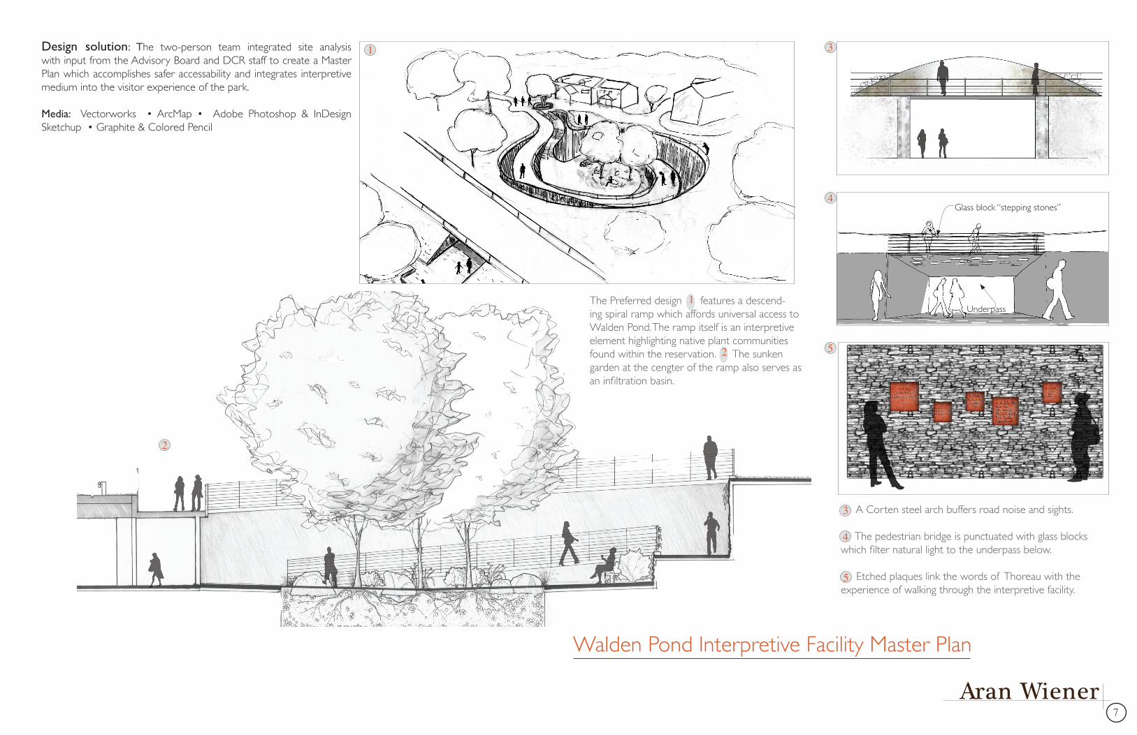
Design solution: The two-person team integrated site analysis with input from the Advisory Board and DCR staff to create a Master Plan which accomplishes safer accessability and integrates interpretive medium into the visitor experience of the park.
Media: Vectorworks • ArcMap • Adobe Photoshop & InDesign Sketchup • Graphite & Colored Pencil
Glass block “stepping stones”
Underpass
A Corten steel arch buffers road noise and sights.
The pedestrian bridge is punctuated with glass blocks which filter natural light to the underpass below.
Etched plaques link the words of Thoreau with the experience of walking through the interpretive facility.
1
The Preferred design features a descend-ing spiral ramp which affords universal access to Walden Pond. The ramp itself is an interpretive element highlighting native plant communities found within the reservation. The sunken garden at the cengter of the ramp also serves as an infiltration basin.
1
2
2
3
3
4
5
5
4
Walden Pond Interpretive Facility Master Plan
88
THE DANIEL LANGER PROPERTY lies at a cross-roads of woodland, wetland, perennial brook, farmland, and human communities.
While the views of fields and forests have served as a precious lifeline, Dan longs to directly interact with the diversity of nature on his own property.
A right of way on the northern border of the Langer property defines a rough trail that serves as a gateway to the forests west of the property and is used by several people in the immediate community. That trail is not wheelchair accessible.
Sun/Shade analyses (left) combined with legal setbacks and conservation restrictions (above) played a crucial role in determining the best locations for gardens, paths, and solar panels.
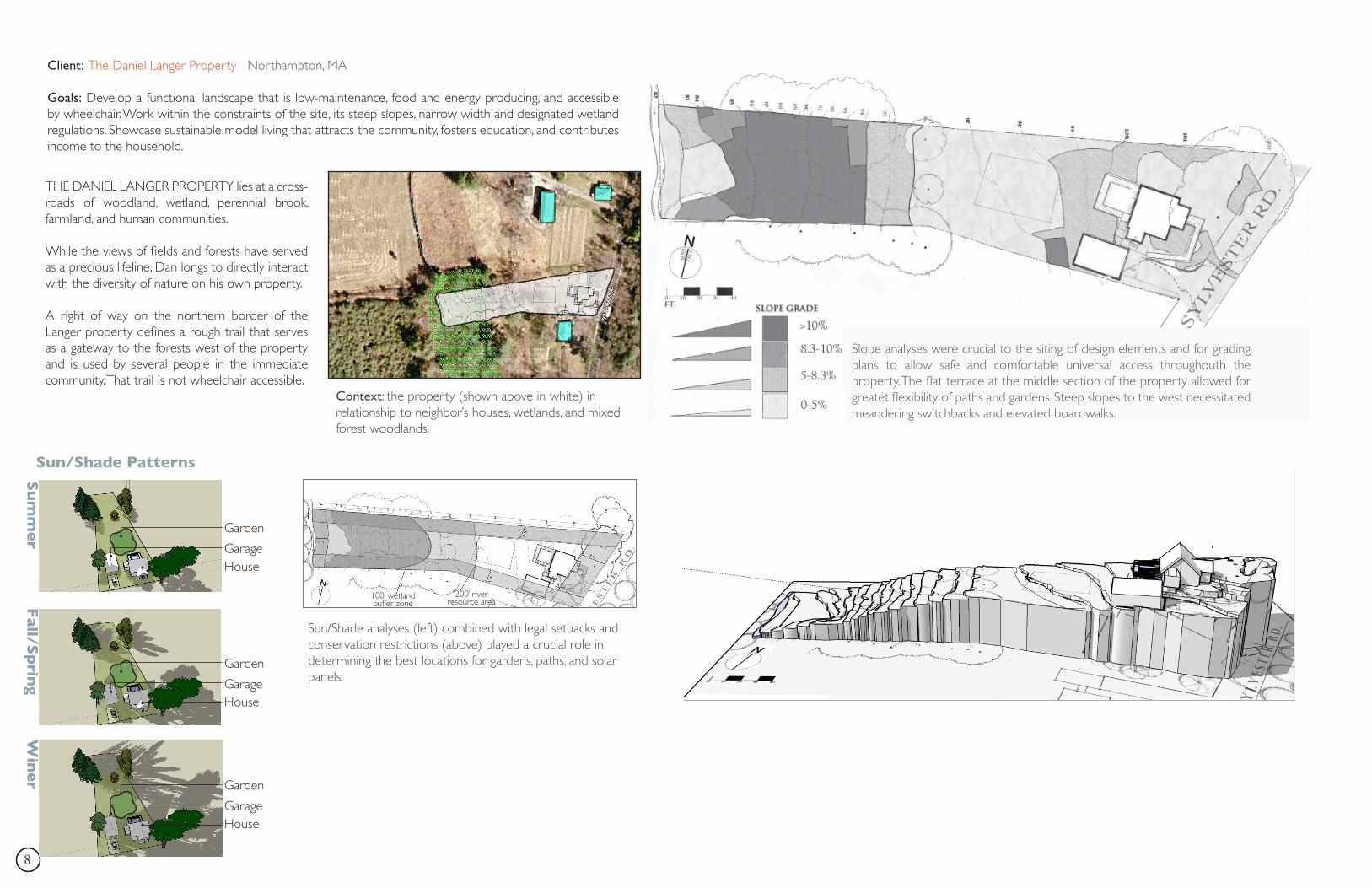
Context: the property (shown above in white) in relationship to neighbor’s houses, wetlands, and mixed forest woodlands.
Client: The Daniel Langer Property Northampton, MA
Goals: Develop a functional landscape that is low-maintenance, food and energy producing, and accessible by wheelchair. Work within the constraints of the site, its steep slopes, narrow width and designated wetland regulations. Showcase sustainable model living that attracts the community, fosters education, and contributes income to the household.
Slope analyses were crucial to the siting of design elements and for grading plans to allow safe and comfortable universal access throughouth the property. The flat terrace at the middle section of the property allowed for greatet flexibility of paths and gardens. Steep slopes to the west necessitated meandering switchbacks and elevated boardwalks.
100’ wetlandbuffer zone
200’ river resource area
Su
mm
er
Sun/Shade Patterns
Fall/S
prin
gW
ine
r
HouseGarage
Garden
HouseGarage
Garden
HouseGarage
Garden
9Aran Wiener
Daniel Langer Residence
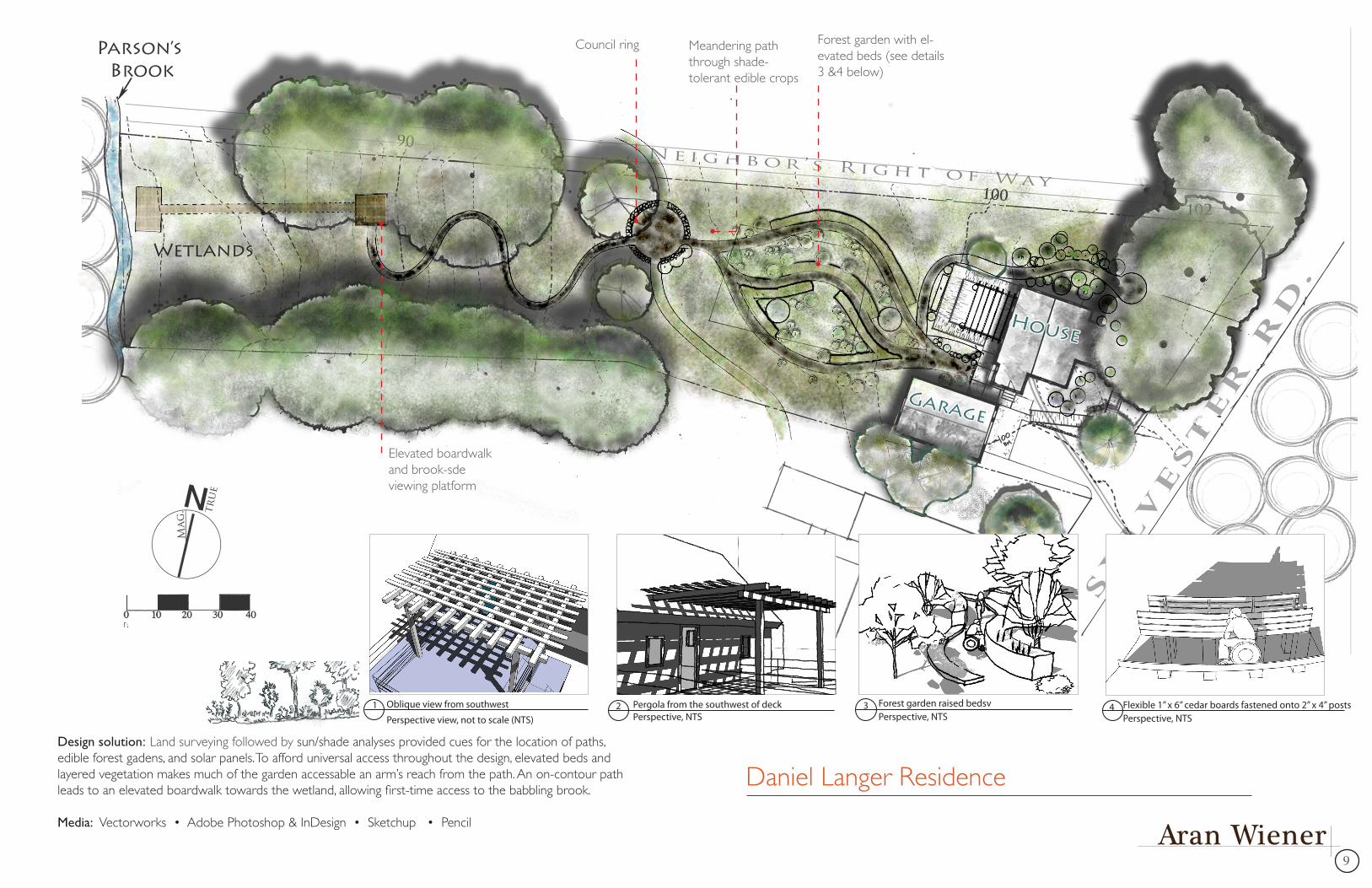
Forest garden with el-evated beds (see details 3 &4 below)
Council ring Meandering path through shade-tolerant edible crops
Elevated boardwalk and brook-sde viewing platform
Oblique view from southwest
Perspective view, not to scale (NTS)1 Pergola from the southwest of deck
Perspective, NTS2 Forest garden raised bedsv
Perspective, NTS3 Flexible 1” x 6” cedar boards fastened onto 2” x 4” posts
Perspective, NTS4
Design solution: Land surveying followed by sun/shade analyses provided cues for the location of paths, edible forest gadens, and solar panels. To afford universal access throughout the design, elevated beds and layered vegetation makes much of the garden accessable an arm’s reach from the path. An on-contour path leads to an elevated boardwalk towards the wetland, allowing first-time access to the babbling brook.
Media: Vectorworks • Adobe Photoshop & InDesign • Sketchup • Pencil
1010
Hamilton
Flatbush Avenue
Newfield Avenue
New Britain Av-
CHANNELIZED RIVER
RIVER BUFFERS/ GREENWAY
COMMERCIAL LOTS
RESIDENTIAL BACKYARDS
A Tour of the South Branch of the
Park River
1
2
3
4
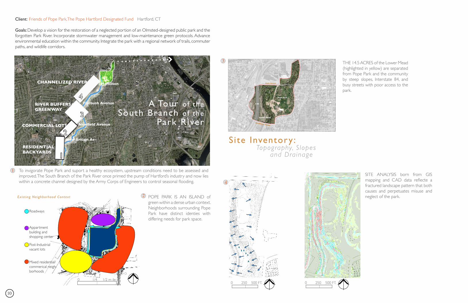
Client: Friends of Pope Park,The Pope Hartford Designated Fund Hartford, CT
Goals: Develop a vision for the restoration of a neglected portion of an Olmsted-designed public park and the forgotten Park River. Incorporate stormwater management and low-maintenance green protocols. Advance environmental education within the community. Integrate the park with a regional network of trails, commuter paths, and wildlife corridors.
Pope Park is an island of green within a dense, urban residential and commercial
neighborhood.
Ex i s t ing Ne ighborhood Context
To invigorate Pope Park and suport a healthy ecosystem, upstream conditions need to be assessed and improved. The South Branch of the Park River once primed the pump of Hartford’s industry and now lies within a concrete channel designed by the Army Corps of Engineers to control seasonal flooding.
Roadways
Appartment building and shopping center
Post-Industrial vacant lots
Mixed residential/commerical neigh-borhoods
POPE PARK IS AN ISLAND of green within a dense urban context. Neighborhoods surrounding Pope Park have distinct identies with differing needs for park space.
1
2
Site Inventory : Topography, S lopes and Dra inage
Park Street
Hamilton Street
Pope Park
Lower Mead
I-84
3 THE 14.5 ACRES of the Lower Mead (highlighted in yellow) are separated from Pope Park and the community by steep slopes, Interstate 84, and busy streets with poor access to the park.
SITE ANALYSIS born from GIS mapping and CAD data reflecte a fractured landscape pattern that both causes and perpetuates misuse and neglect of the park.
4
0 250 500 FT. 0 250 500 FT.0 1/4 1/2 m ile
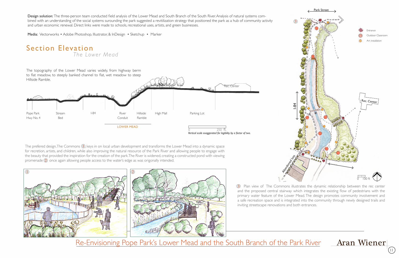
11Aran Wiener
Sect ion E levat ion The Lower Mead
Stream Bed
Pope ParkHwy No. 4
I-84 RiverConduit
Hillside Ramble
High Mall Parking Lot
Rec. Center
LOWER MEAD
The topography of the Lower Mead varies widely, from highway berm to flat meadow, to steeply banked channel to flat, wet meadow to steep Hillside Ramble.
Vertical scale exaggerated for legibility by a factor of two.
Park Street
I-84
Rec. Center
Aban
done
d lo
ts
The prefered design, The Commons , keys in on local urban development and transforms the Lower Mead into a dynamic space for recretion, artists, and children, while also improving the natural resource of the Park River and allowing people to engage with the beauty that provided the inspiration for the creation of the park. The River is widened, creating a constructed pond with viewing promenade once again allowing people access to the water’s edge as was origonally intended.
1
1 2
2
Plan view of The Commons illustrates the dynamic relationship between the rec center and the proposed central stairway which integrates the existing flow of pedestrians with the primary water feature of the Lower Mead. The design promotes community involvement and a safe recreation space and is integrated into the community through newly designed trails and inviting streetscape renovations and both entrances.
Entrance
Outdoor Classroom
Art installation
Re-Envisioning Pope Park’s Lower Mead and the South Branch of the Park River
3
3
0 100 ft
0 250 ft.
Design solution: The three-person team conducted field analysis of the Lower Mead and South Branch of the South River. Analysis of natural systems com-bined with an understanding of the social systems surounding the park suggested a revitilization strategy that positioned the park as a hub of community activity and urban economic renewal. Direct links were made to schools, recreational uses, artists, and green businesses.
Media: Vectorworks • Adobe Photoshop, Illustrator, & InDesign • Sketchup • Marker
1212
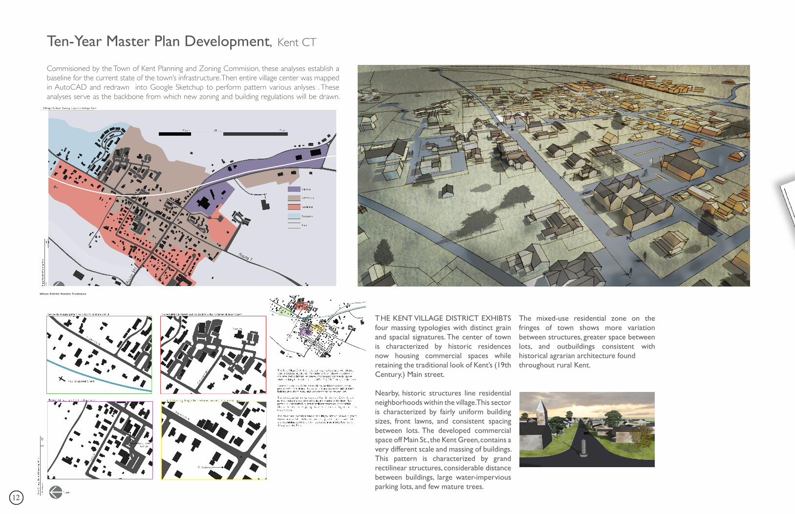
Ten-Year Master Plan Development, Kent CT
Commisioned by the Town of Kent Planning and Zoning Commision, these analyses establish a baseline for the current state of the town’s infrastructure. Then entire village center was mapped in AutoCAD and redrawn into Google Sketchup to perform pattern various anlyses . These analyses serve as the backbone from which new zoning and building regulations will be drawn.
THE KENT VILLAGE DISTRICT EXHIBTS four massing typologies with distinct grain and spacial signatures. The center of town is characterized by historic residences now housing commercial spaces while retaining the traditional look of Kent’s (19th Century.) Main street.
Nearby, historic structures line residential neighborhoods within the village. This sector is characterized by fairly uniform building sizes, front lawns, and consistent spacing between lots. The developed commercial space off Main St., the Kent Green, contains a very different scale and massing of buildings. This pattern is characterized by grand rectilinear structures, considerable distance between buildings, large water-impervious parking lots, and few mature trees.
The mixed-use residential zone on the fringes of town shows more variation between structures, greater space between lots, and outbuildings consistent with historical agrarian architecture foundthroughout rural Kent.
13Aran Wiener
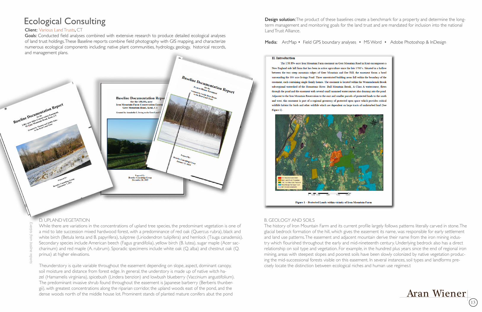
B. GEOLOGY AND SOILSThe history of Iron Mountain Farm and its current profile largely follows patterns literally carved in stone. The glacial bedrock formation of the hill, which gives the easement its name, was responsible for early settlement and land use patterns. The easement and adjacent mountain derive their name from the iron mining indus-try which flourished throughout the early and mid-nineteenth century. Underlying bedrock also has a direct relationship on soil type and vegetation. For example, in the hundred plus years since the end of regional iron mining, areas with steepest slopes and poorest soils have been slowly colonized by native vegetation produc-ing the mid-successional forests visible on this easement. In several instances, soil types and landforms pre-cisely locate the distinction between ecological niches and human use regimes.t
D. UPLAND VEGETATIONWhile there are variations in the concentrations of upland tree species, the predominant vegetation is one of a mid to late succession mixed hardwood forest, with a predominance of red oak (Quercus rubra), black and white birch (Betula lenta and B. papyrifera), tuliptree (Liriodendron tulipifera) and hemlock (Tsuga canadensis). Secondary species include American beech (Fagus grandifolia), yellow birch (B. lutea), sugar maple (Acer sac-charinum) and red maple (A. rubrum). Sporadic specimens include white oak (Q. alba) and chestnut oak (Q. prinus) at higher elevations.
Theunderstory is quite variable throughout the easement depending on slope, aspect, dominant canopy, soil moisture and distance from forest edge. In general, the understory is made up of native witch ha-zel (Hamamelis virginiana), spicebush (Lindera benzion) and lowbush blueberry (Vaccinium angustifolium). The predominant invasive shrub found throughout the easement is Japanese barberry (Berberis thunber-gii), with greatest concentrations along the riparian corridor, the upland woods east of the pond, and the dense woods north of the middle house lot. Prominent stands of planted mature conifers abut the pond
Design solution:The product of these baselines create a benchmark for a property and determine the long-term management and monitoring goals for the land trust and are mandated for inclusion into the national Land Trust Alliance.
Media: ArcMap • Field GPS boundary analyses • MS Word • Adobe Photoshop & InDesign
Client: Various Land Trusts, CTGoals: Conducted field analyses combined with extensive research to produce detailed ecological analyses of land trust holdings. These Baseline reports combine field photography with GIS mapping, and characterize numerous ecological components including: native plant communities, hydrology, geology, historical records, and management plans.
Ecological Consulting
Exerpts from basline reports
1414
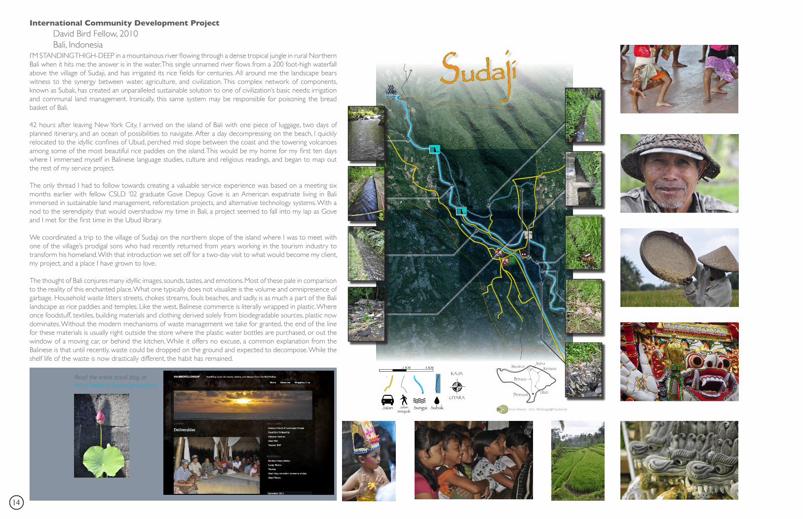
International Community Development Project David Bird Fellow, 2010 Bali, IndonesiaI’M STANDING THIGH-DEEP in a mountainous river flowing through a dense tropical jungle in rural Northern Bali when it hits me: the answer is in the water. This single unnamed river flows from a 200 foot-high waterfall above the village of Sudaji, and has irrigated its rice fields for centuries. All around me the landscape bears witness to the synergy between water, agriculture, and civilization. This complex network of components, known as Subak, has created an unparalleled sustainable solution to one of civilization’s basic needs; irrigation and communal land management. Ironically, this same system may be responsible for poisoning the bread basket of Bali.
42 hours after leaving New York City, I arrived on the island of Bali with one piece of luggage, two days of planned itinerary, and an ocean of possibilities to navigate. After a day decompressing on the beach, I quickly relocated to the idyllic confines of Ubud, perched mid slope between the coast and the towering volcanoes among some of the most beautiful rice paddies on the island. This would be my home for my first ten days where I immersed myself in Balinese language studies, culture and religious readings, and began to map out the rest of my service project.
The only thread I had to follow towards creating a valuable service experience was based on a meeting six months earlier with fellow CSLD ’02 graduate Gove Depuy. Gove is an American expatriate living in Bali immersed in sustainable land management, reforestation projects, and alternative technology systems. With a nod to the serendipity that would overshadow my time in Bali, a project seemed to fall into my lap as Gove and I met for the first time in the Ubud library.
We coordinated a trip to the village of Sudaji on the northern slope of the island where I was to meet with one of the village’s prodigal sons who had recently returned from years working in the tourism industry to transform his homeland. With that introduction we set off for a two-day visit to what would become my client, my project, and a place I have grown to love.
The thought of Bali conjures many idyllic images, sounds, tastes, and emotions. Most of these pale in comparison to the reality of this enchanted place. What one typically does not visualize is the volume and omnipresence of garbage. Household waste litters streets, chokes streams, fouls beaches, and sadly, is as much a part of the Bali landscape as rice paddies and temples. Like the west, Balinese commerce is literally wrapped in plastic. Where once foodstuff, textiles, building materials and clothing derived solely from biodegradable sources, plastic now dominates. Without the modern mechanisms of waste management we take for granted, the end of the line for these materials is usually right outside the store where the plastic water bottles are purchased, or out the window of a moving car, or behind the kitchen. While it offers no excuse, a common explanation from the Balinese is that until recently, waste could be dropped on the ground and expected to decompose. While the shelf life of the waste is now drastically different, the habit has remained.
Read the entire travel blog at:http://balibird10.wordpress.com/
Jalan JalanSetapak
Sungai Subak
.5 KM 1 KM
KAJA
UTARA
Sudajiv
Aran Wiener 2010 [email protected]
Sudaji
denpaSSarubud
Kintamani
bedugul
Singaraja

15Aran Wiener
Client: Positve Space Sculpture Garden Philiadelphia, PA
Goals: With the assistance of the Day Street Design Collaborative, the following plan set was created from the con-cepts and information generated from a three-day design charrette in April 2009. The charrette brought together professional planners and designers, students from the Conway School of Landscape design and local artists, who sat down together and analyzed, discussed, and produced sketches for a vacant lot in Philadelphia.
Design solution: Three alternative designs were put forth that addressed sustainable stormwater management, low-maintenance landscaping, artist installations, performance space, and strategies for integrating the sculpture garden into the web of the urban matrix surounding it.
Media: InDesign • Marker • PencilIn the artist network’s words, “Positive Space Sculpture Garden will provide an opportunity for Fishtown and East Kensington artists to make and exhibit art in our community, to create a beautiful and thought provoking green space, and to educate our community on art, greening and sustainability.”

1616
Landscape Installations Fine Gardening Edible Landscapes Native Landscapes
COMPLETED PROJECTS
17Aran Wiener
Native Landscapes
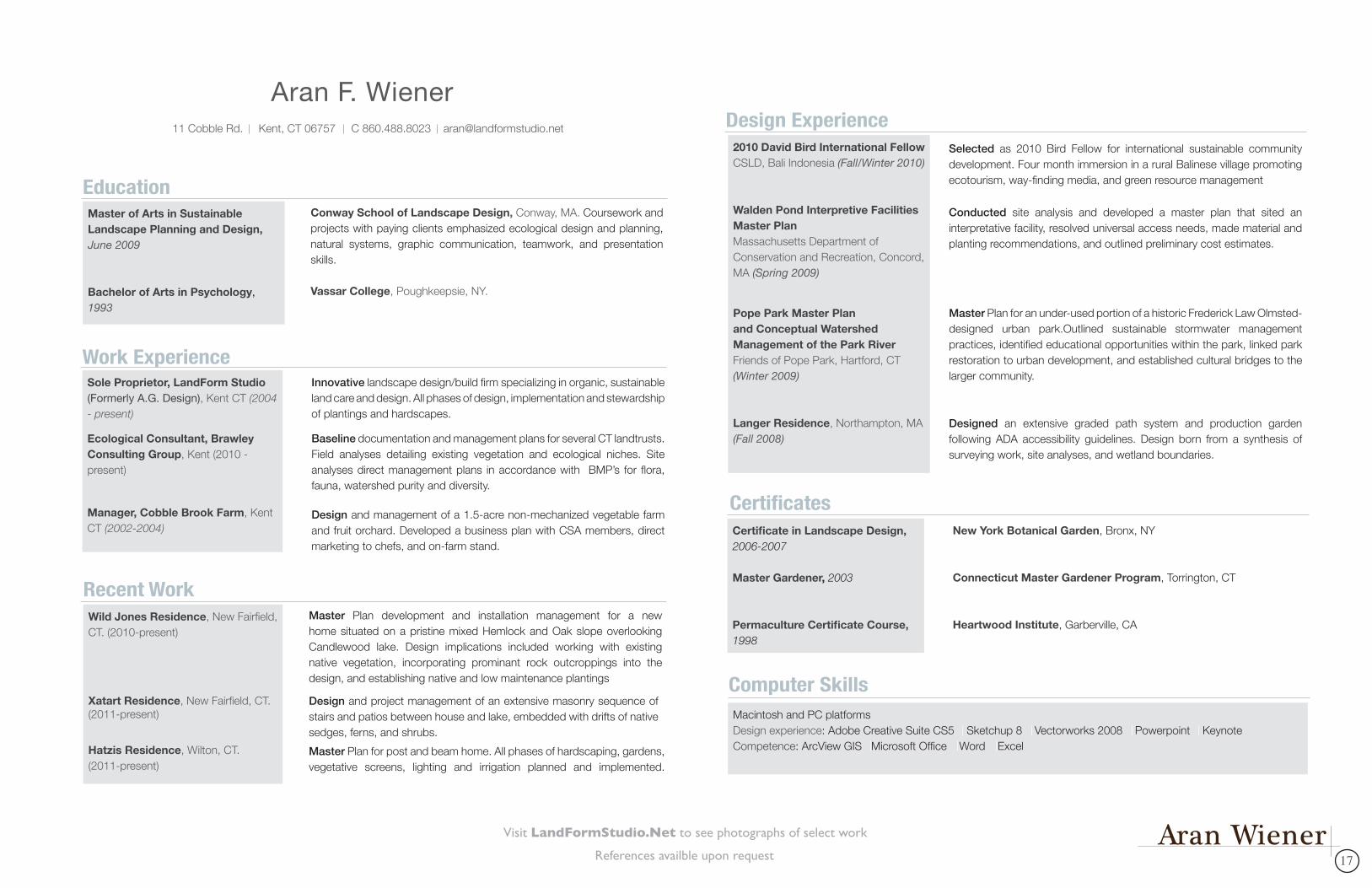
11 Cobble Rd. Kent, CT 06757 C 860.488.8023 [email protected]
Aran F. Wiener
Conway School of Landscape Design, Conway, MA. Coursework and projects with paying clients emphasized ecological design and planning, natural systems, graphic communication, teamwork, and presentation skills.
Vassar College, Poughkeepsie, NY.
EducationMaster of Arts in Sustainable Landscape Planning and Design, June 2009
Bachelor of Arts in Psychology, 1993
Portfolio and References available upon requestPage 1 of 2
Recent WorkMaster Plan development and installation management for a new home situated on a pristine mixed Hemlock and Oak slope overlooking Candlewood lake. Design implications included working with existing native vegetation, incorporating prominant rock outcroppings into the design, and establishing native and low maintenance plantings
Wild Jones Residence, New Fairfield, CT. (2010-present)
Xatart Residence, New Fairfield, CT. (2011-present)
Hatzis Residence, Wilton, CT. (2011-present)
Master Plan for post and beam home. All phases of hardscaping, gardens, vegetative screens, lighting and irrigation planned and implemented.
Design and project management of an extensive masonry sequence of stairs and patios between house and lake, embedded with drifts of native sedges, ferns, and shrubs.
Work ExperienceInnovative landscape design/build firm specializing in organic, sustainable land care and design. All phases of design, implementation and stewardship of plantings and hardscapes.
Baseline documentation and management plans for several CT landtrusts. Field analyses detailing existing vegetation and ecological niches. Site analyses direct management plans in accordance with BMP’s for flora, fauna, watershed purity and diversity.
Design and management of a 1.5-acre non-mechanized vegetable farm and fruit orchard. Developed a business plan with CSA members, direct marketing to chefs, and on-farm stand.
Sole Proprietor, LandForm Studio (Formerly A.G. Design), Kent CT (2004 - present)
Ecological Consultant, Brawley Consulting Group, Kent (2010 - present)
Manager, Cobble Brook Farm, Kent CT (2002-2004)
References availble upon request
Visit LandFormStudio.Net to see photographs of select work
11 Cobble Rd. Kent, CT 06757 C 860.488.8023 [email protected]
Aran F. Wiener
Conway School of Landscape Design, Conway, MA. Coursework and projects with paying clients emphasized ecological design and planning, natural systems, graphic communication, teamwork, and presentation skills.
Vassar College, Poughkeepsie, NY.
EducationMaster of Arts in Sustainable Landscape Planning and Design, June 2009
Bachelor of Arts in Psychology, 1993
Recent WorkMaster Plan development and installation management for a new home situated on a pristine mixed Hemlock and Oak slope overlooking Candlewood lake. Design implications included working with existing native vegetation, incorporating prominant rock outcroppings into the design, and establishing native and low maintenance plantings
Wild Jones Residence, New Fairfield, CT. (2010-present)
Xatart Residence, New Fairfield, CT. (2011-present)
Hatzis Residence, Wilton, CT. (2011-present)
Master Plan for post and beam home. All phases of hardscaping, gardens, vegetative screens, lighting and irrigation planned and implemented.
Design and project management of an extensive masonry sequence of stairs and patios between house and lake, embedded with drifts of native sedges, ferns, and shrubs.
Work ExperienceInnovative landscape design/build firm specializing in organic, sustainable land care and design. All phases of design, implementation and stewardship of plantings and hardscapes.
Baseline documentation and management plans for several CT landtrusts. Field analyses detailing existing vegetation and ecological niches. Site analyses direct management plans in accordance with BMP’s for flora, fauna, watershed purity and diversity.
Design and management of a 1.5-acre non-mechanized vegetable farm and fruit orchard. Developed a business plan with CSA members, direct marketing to chefs, and on-farm stand.
Sole Proprietor, LandForm Studio (Formerly A.G. Design), Kent CT (2004 - present)
Ecological Consultant, Brawley Consulting Group, Kent (2010 - present)
Manager, Cobble Brook Farm, Kent CT (2002-2004)
CertificatesNew York Botanical Garden, Bronx, NY
Connecticut Master Gardener Program, Torrington, CT
Heartwood Institute, Garberville, CA
Certificate in Landscape Design, 2006-2007
Master Gardener, 2003
Permaculture Certificate Course, 1998
Macintosh and PC platformsDesign experience: Adobe Creative Suite CS5 Sketchup 8 Vectorworks 2008 Powerpoint KeynoteCompetence: ArcView GIS Microsoft Office Word Excel
Computer Skills
Master Plan for an under-used portion of a historic Frederick Law Olmsted-designed urban park.Outlined sustainable stormwater management practices, identified educational opportunities within the park, linked park restoration to urban development, and established cultural bridges to the larger community.
Designed an extensive graded path system and production garden following ADA accessibility guidelines. Design born from a synthesis of surveying work, site analyses, and wetland boundaries.
Conducted site analysis and developed a master plan that sited an interpretative facility, resolved universal access needs, made material and planting recommendations, and outlined preliminary cost estimates.
2010 David Bird International FellowCSLD, Bali Indonesia (Fall/Winter 2010)
Walden Pond Interpretive Facilities Master PlanMassachusetts Department of Conservation and Recreation, Concord, MA (Spring 2009)
Pope Park Master Plan and Conceptual Watershed Management of the Park RiverFriends of Pope Park, Hartford, CT (Winter 2009)
Langer Residence, Northampton, MA (Fall 2008)
Design ExperienceSelected as 2010 Bird Fellow for international sustainable community development. Four month immersion in a rural Balinese village promoting ecotourism, way-finding media, and green resource management

181811 cobble rd. kent, Ct 06757 C 860.488.8023 [email protected]