scheduling and control of unmanned ground vehicles for...
TRANSCRIPT
180
Scheduling and Control of Unmanned Ground Vehicles for Precision Farming: A Real-time Navigation Tool
Dimitrios Bechtsis1, Vasileios Moisiadis2, Naoum Tsolakis3, Dimitrios Vlachos4 Dionysis Bochtis2
1Department of Automation Engineering, Alexander Technological Educational Institute of Thessaloniki, Greece, e-mail: [email protected]
2Institute for Bio-economy and Agri-technology (IBO), Centre for Research & Technology-Hellas (CERTH), 6th km Charilaou-Thermi Rd, GR 57001 Thermi, Thessaloniki, Greece
3Centre for International Manufacturing, Institute for Manufacturing, Department of Engineering, University of Cambridge, United Kingdom
4Aristotle University of Thessaloniki, Department of Mechanical Engineering, Greece
Abstract. Autonomous systems are a promising alternative for effectively executing agricultural field management strategies. Unmanned Ground Vehicles perform farming activities on custom agricultural fields, using real-time navigation. The aim of this study is to provide a software tool for optimizing accuracy and efficiency in precision farming activities, hence leading to improved farming output, while dynamically addressing operational and tactical level uncertainties. This paper contributes to the operations research field by allowing the application of simulated results direct to the guidance of a physical vehicle. Unlike existing sophisticated tools, the developed navigation mechanism is user-friendly and highly customizable at outdoor navigation.
Keywords: Unmanned Ground Vehicles, Precision farming, Robot Operating System, Real-time navigation.
1 Introduction
The paper focuses on the real-time scheduling and control of Unmanned Ground Vehicles (UGVs) designed to perform precision farming activities on custom agricultural fields, under the occurrence of any geomorphological and environmental uncertainties. More specifically, the aim of this study is to provide a software tool for the real-time navigation of UGVs in agricultural fields to optimize accuracy and efficiency in precision farming activities, hence leading to improved farming output, while dynamically addressing operational and tactical level uncertainties.
Research that motivates the integration of the UGV's ramifications onto the SC ecosystem in general is not sufficient (Bechtsis et al., 2017) and this is also projected to the agricultural sector. In traditional agriculture, farmers’ lack of accuracy and lack of proper feedback leads to: (i) loss of situation awareness (Walker et al., 2008), (ii) vigilance decrement (Finomore et al., 2009), (iii) complacency (Kaber and Endsley, 2004), and (iv) skill degradation and human errors (Billings, 1996). In this
181
regard, semi- or fully-autonomous vehicles that are controlled by computers (Ho et al., 2012) are being used to address such difficulties and increase agricultural operations efficiency (Zheng et al., 2016). More specifically, autonomous systems are a promising alternative for effectively executing agricultural field management strategies and agricultural operations considering that UGVs: (i) provide business intelligence with real-time feedback on field’s parameters, (ii) can better handle throughput volatility, (iii) can optimally operate autonomously on a 24/7 shift with reliable performance, (iv) save energy compared to conventional man-driven farming vehicles, (v) promote the smart agriculture vision, and (vi) increase safety at the field level.
Despite the evident benefits of UGVs in agriculture, the application of autonomous mechanization in the sector is challenged by inherent factors including both field geometry and morphology particularities (Bochtis and Sørensen, 2009), and environmental uncertainties like volatile weather conditions and encounters with random objects and obstacles (Bochtis et al., 2014). This calls for automated systems with scheduling and control intelligence capabilities that evaluate alternative navigation decisions based on real-time feedback including field’s and crops’ states assessed through real-time data (Wulfsohn et al., 2012). However, existing systems have not been able to overcome problems such as low resolution maps, low positioning accuracy, low grade process automation and incorrect or incomplete measurements.
The aim of this paper is to present an engineering-driven system for the scheduling and control of agricultural UGVs with the objective of executing precision farming activities in an optimal manner, form an intra-logistics field operations perspective. The research principle relies on the basic hypothesis that an agricultural field presents obstacles (both random and static) that a UGV should detect and recalculate an optimal pathway to perform its farming tasks. A key theoretical contribution in the existing body of literature is the proposition of a UGV software tool for the real-time field recognition that guides the vehicle to execute its precision farming activities whilst allowing for a better usage of resources and potentially a better harvest.
The remainder of the manuscript is organized as follows. In Section 2 we provide the system description, along with the required input and operational data, and the field monitoring process. In Section 3, we discuss the key findings of the simulation tool in a conceptual field. Finally, in Section 4 we wrap-up with conclusions and limitations, while we further outline beyond state-of-the-art applications of the proposed system in the agricultural sector.
2 System Description
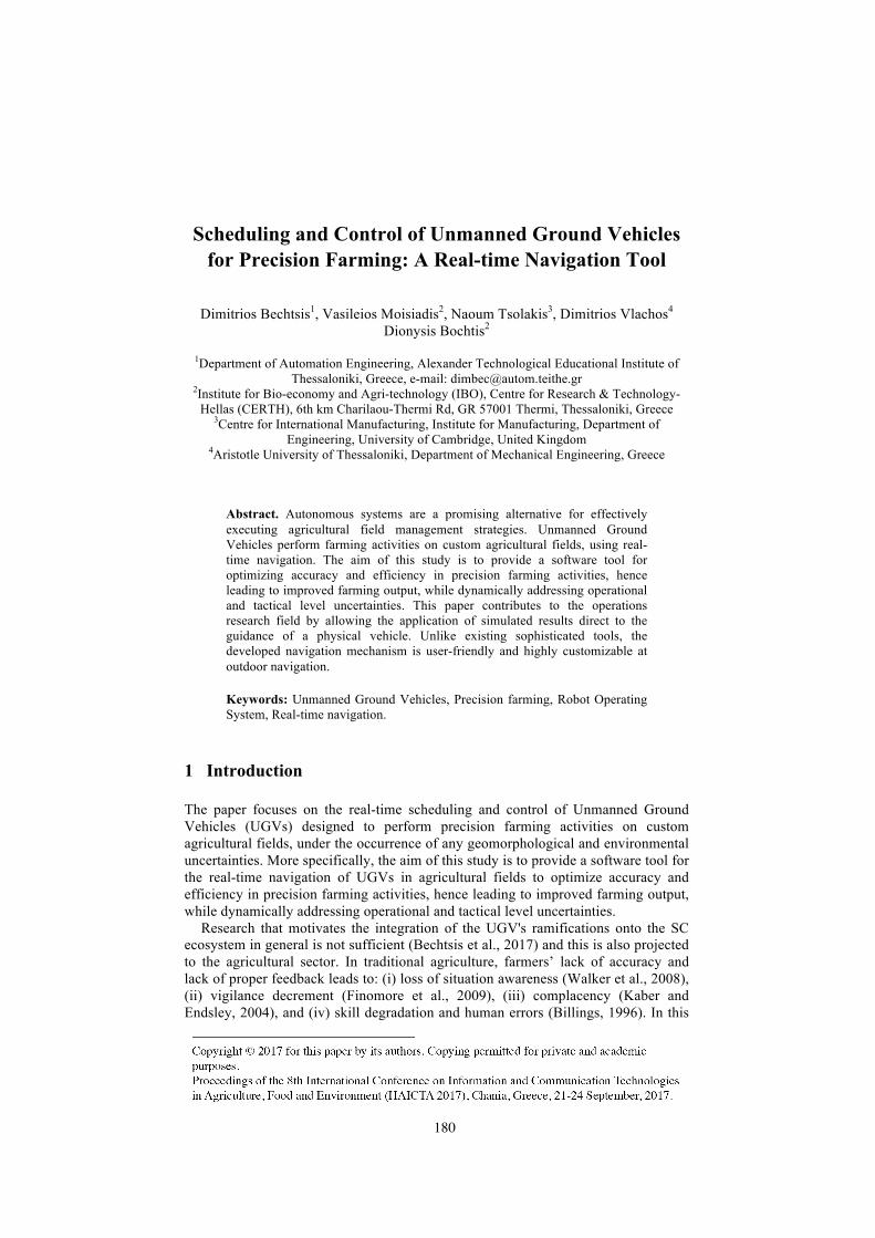
The proposed simulation system aims to navigate an UGV in custom agricultural fields to perform related precision farming activities (e.g. seeding, spraying, and fertilizing). The proposed system basically comprises of an information system that consists of the following: (i) field layer representing the landscape and the static objects (obstacles, trees), (ii) simulation layer which includes the action agents –
182
representing the UGV whose task is to perform precision farming activities, (iii) message layer – representing the continuous transactions between the system nodes to produce and manage raw data, and (iv) application layer which handles all the vehicles activities including the action scheduler and the data acquisition block – determining, prioritizing and optimally scheduling the optimal navigation pathway of the UGV in the field based on encounters with obstacles and any particular geomorphological characteristics.
From a farm’s geometrical area perspective, the devised system regards the most common area coverage practice which involves a set of parallel field-work tracks, or trips, which starts at one boundary of the field and terminates at the opposite boundary (Bochtis et al., 2012). In the exemplar demonstrator case under study, we consider a set of five -equidistant- parallel tracks. An overview of the system components as well as their inter-connections and related processes is presented in Fig. 1.
• Nodes• Topics• ActionServer/Publish• ActionClient/Subscribe
• RobotJoints• RobotLinks• RobotSensors• RobotActuators
rqt_graph
Rvis
Rvis
Gazebo
Gazebo
• Landscape• StaticObjects
Objects/ActionsROSTools
Fig. 1. Overview of the system components and related inter-connections.
2.1 Simulation Model Development
At the proposed research paper the Robot Operating System (ROS) is used to simulate an autonomous vehicle’s farming activities. The model’s layout is created at the Gazebo simulation tool; for optimized path tracking, the inherent ROS Simultaneous Localization And Mapping (SLAM) procedure informs the UGV's movement.
ROS is powerful and robust software with numerous third-party compatible tools and relies on an extensive community of users and researchers that support it. A significant number of ready to use outdoor robotic systems are compatible with ROS. Indicatively, the Husky research robot developed by Clearpath (https://www.clearpathrobotics.com/) and the Thorvald multipurpose agricultural
183
vehicle by SAGA robotics (https://sagarobotics.com/) are two well-established examples. Simulation, on the other hand, offers a test bed for developing algorithms and testing different UGV properties on various fields (Farinelly et al., 2016). ROS allows researchers to elaborate their ideas and safely simulate them at a lab level, before testing them on the field.
2.2 Field and Operational Level Parameters
2.2.1 Field Representation
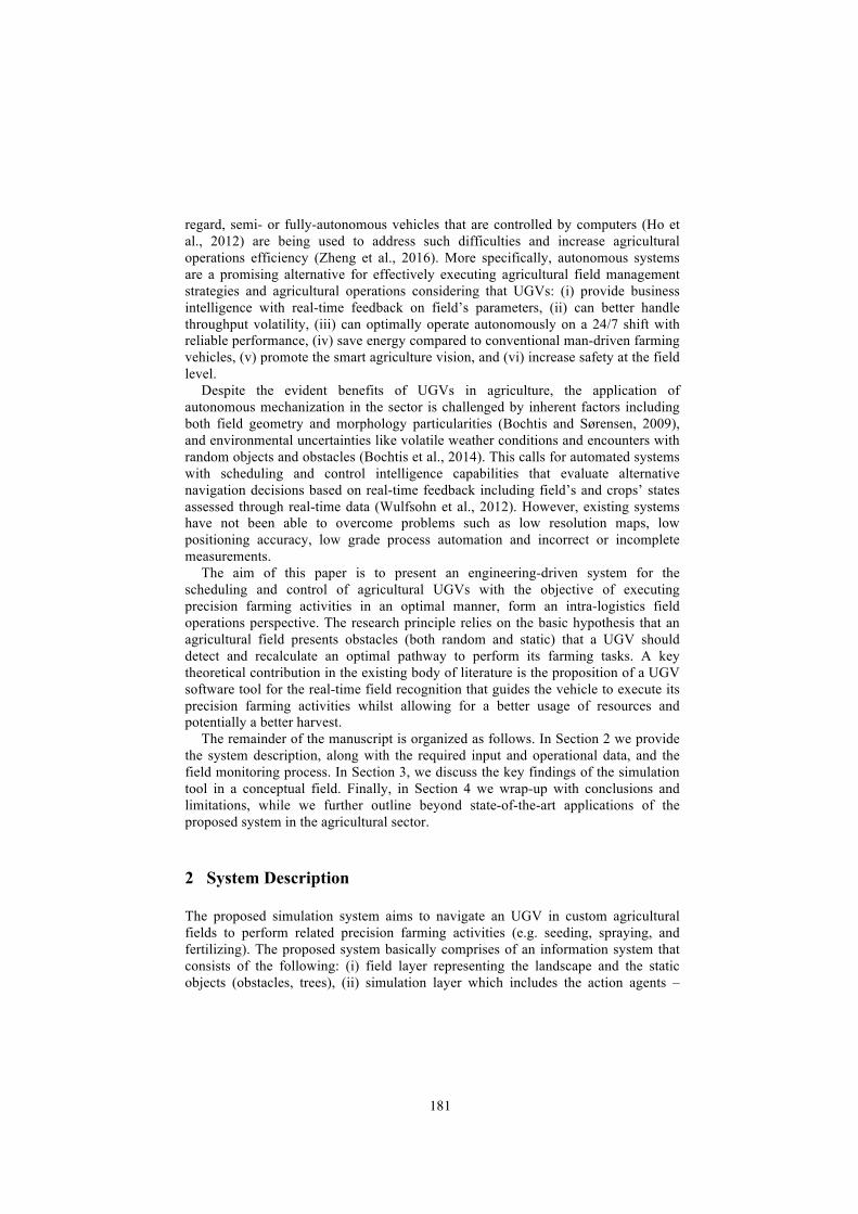
Initially, a 3-dimensional (3-D) coordinate system is assigned to the field. The 3D world model is the simulation environment of the robot. Gazebo offers the tools for building the facility layout of the robot's world and the user can add texture, color and even objects. Fig. 2 depicts the experimental five-row crop cultivation field. The model’s layout was created at the Gazebo simulation tool using the extensible markup language and the Digital Elevation Model (DEM) for a 3-D representation of the terrain. By convention Gazebo platform uses the right-handed coordinate system, with X- and Y-axes in the plane, and Z-axis increasing with the altitude.
Fig. 2. The reference geomorphology of the experimental agricultural field.
2.2.2 Field-Specific Data
Field-specific data are associated with the direct field attributes, including: • Field boundaries – The vehicle navigates in a pre-specific region in order to map
the field's layout. Field boundaries should be introduced either directly by passing the absolute coordinates of the field's boundaries to the system or indirectly by means of specific physical landscape morphology (hills with intense slope around the field).
• Field coordinates – The field includes the crop lines and several physical obstacles (rocks, trees and hills). The map creation process identifies the field's layout and the vehicle can navigate to specific coordinates using a global
184
optimum path. The start and end points of each field-work track can be passed as arguments to the system.
• Potential obstacles – The vehicle identifies potential obstacles as a result of the field area scanning procedure, after sending the original signal the vehicle interprets the signals’ feedback of any spatially distributed obstacles to relative map coordinates.
• Driving direction – This regards the direction of the parallel field-work tracks and is obtained using the field's map.
2.2.3 Operation-Specific Data
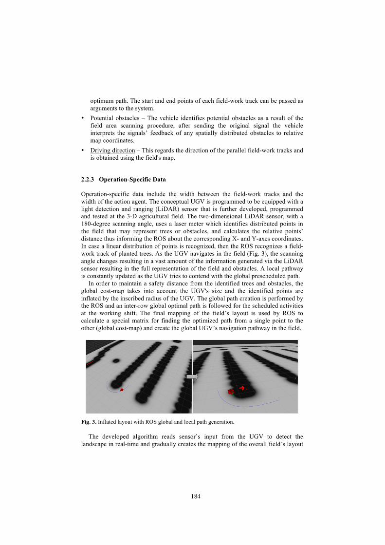
Operation-specific data include the width between the field-work tracks and the width of the action agent. The conceptual UGV is programmed to be equipped with a light detection and ranging (LiDAR) sensor that is further developed, programmed and tested at the 3-D agricultural field. The two-dimensional LiDAR sensor, with a 180-degree scanning angle, uses a laser meter which identifies distributed points in the field that may represent trees or obstacles, and calculates the relative points’ distance thus informing the ROS about the corresponding X- and Y-axes coordinates. In case a linear distribution of points is recognized, then the ROS recognizes a field-work track of planted trees. As the UGV navigates in the field (Fig. 3), the scanning angle changes resulting in a vast amount of the information generated via the LiDAR sensor resulting in the full representation of the field and obstacles. A local pathway is constantly updated as the UGV tries to contend with the global prescheduled path.
In order to maintain a safety distance from the identified trees and obstacles, the global cost-map takes into account the UGV's size and the identified points are inflated by the inscribed radius of the UGV. The global path creation is performed by the ROS and an inter-row global optimal path is followed for the scheduled activities at the working shift. The final mapping of the field’s layout is used by ROS to calculate a special matrix for finding the optimized path from a single point to the other (global cost-map) and create the global UGV’s navigation pathway in the field.
Fig. 3. Inflated layout with ROS global and local path generation.
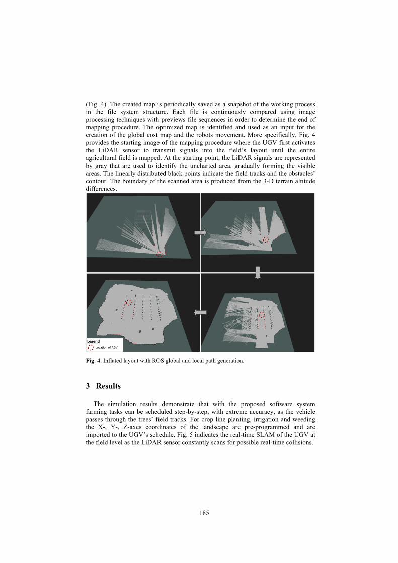
The developed algorithm reads sensor’s input from the UGV to detect the landscape in real-time and gradually creates the mapping of the overall field’s layout
185
(Fig. 4). The created map is periodically saved as a snapshot of the working process in the file system structure. Each file is continuously compared using image processing techniques with previews file sequences in order to determine the end of mapping procedure. The optimized map is identified and used as an input for the creation of the global cost map and the robots movement. More specifically, Fig. 4 provides the starting image of the mapping procedure where the UGV first activates the LiDAR sensor to transmit signals into the field’s layout until the entire agricultural field is mapped. At the starting point, the LiDAR signals are represented by gray that are used to identify the uncharted area, gradually forming the visible areas. The linearly distributed black points indicate the field tracks and the obstacles’ contour. The boundary of the scanned area is produced from the 3-D terrain altitude differences.
Fig. 4. Inflated layout with ROS global and local path generation.
3 Results
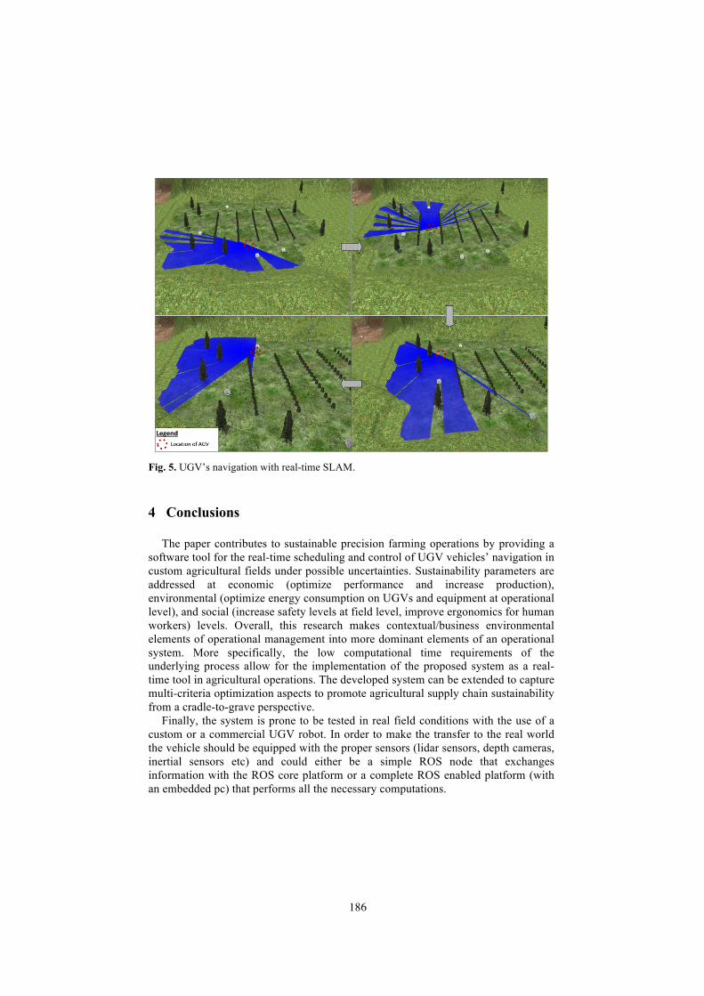
The simulation results demonstrate that with the proposed software system farming tasks can be scheduled step-by-step, with extreme accuracy, as the vehicle passes through the trees’ field tracks. For crop line planting, irrigation and weeding the X-, Y-, Z-axes coordinates of the landscape are pre-programmed and are imported to the UGV’s schedule. Fig. 5 indicates the real-time SLAM of the UGV at the field level as the LiDAR sensor constantly scans for possible real-time collisions.
186
Fig. 5. UGV’s navigation with real-time SLAM.
4 Conclusions
The paper contributes to sustainable precision farming operations by providing a software tool for the real-time scheduling and control of UGV vehicles’ navigation in custom agricultural fields under possible uncertainties. Sustainability parameters are addressed at economic (optimize performance and increase production), environmental (optimize energy consumption on UGVs and equipment at operational level), and social (increase safety levels at field level, improve ergonomics for human workers) levels. Overall, this research makes contextual/business environmental elements of operational management into more dominant elements of an operational system. More specifically, the low computational time requirements of the underlying process allow for the implementation of the proposed system as a real-time tool in agricultural operations. The developed system can be extended to capture multi-criteria optimization aspects to promote agricultural supply chain sustainability from a cradle-to-grave perspective.
Finally, the system is prone to be tested in real field conditions with the use of a custom or a commercial UGV robot. In order to make the transfer to the real world the vehicle should be equipped with the proper sensors (lidar sensors, depth cameras, inertial sensors etc) and could either be a simple ROS node that exchanges information with the ROS core platform or a complete ROS enabled platform (with an embedded pc) that performs all the necessary computations.
187
References
1. Bechtsis, D., Tsolakis, N., Vlachos, D. and Iakovou, E. (2017) Sustainable supply chain management in the digitalisation era: The impact of Automated Guided Vehicles. Journal of Cleaner Production, 142, p.3970-84.
2. Billings, C.E. (1996) Aviation automation: The search for a human-centered approach. Lawrence Erlbaum Associates, Mahwah, NJ, USA.
3. Bochtis, D.D. and Sørensen, C.G. (2009) The vehicle routing problem in field logistics part I. Biosystems Engineering, 104, p.447-57.
4. Bochtis, D.D., Sørensen, C.G. and Busato, P. (2014) Advances in agricultural machinery management: A review. Biosystems Engineering, 126, p.69-81.
5. Bochtis, D.D., Sørensen, C.G. and Green, O. (2012) A DSS for planning of soil-sensitive field operations. Decision Support Systems, 53, 1, p.66-75.
6. Farinelli, A., Boscolo, N., Zanotto, E. and Pagello, E. (2016) Advanced approaches for multi-robot coordination in logistic scenarios, Robotics and Autonomous Systems, In press.
7. Finomore, V., Matthews, G., Shaw, T. and Warm, J. (2009) Predicting vigilance: a fresh look at an old problem. Ergonomics, 52, p.791-808.
8. Ho, Y.-C., Liu, H.-C. and Yih, Y. (2012) A multiple-attribute method for concurrently solving the pickup-dispatching problem and the load-selection problem of multiple-load AGVs. Journal of Manufacturing Systems, 31, p.288-300.
9. Kaber, D.B. and Endsley, M.R. (2004) The effects of level of automation and adaptive automation on human performance, situation awareness and workload in a dynamic control task. Theoretical Issues in Ergonomics Science, 5, p.113-53.
10. Walker, G.H., Stanton, N.A. and Young, M.S. (2008) Feedback and driver situation awareness (SA): a comparison of SA measures and contexts. Transportation Research Part F: Traffic Psychology and Behaviour, 11, p.282-99.
11. Wulfsohn, D., Aravena Zamora, F., Potin Téllez, C., Zamora Lagos, I. and García-Fiñana, M. (2012) Multilevel systematic sampling to estimate total fruit number for yield forecasts. Precision Agriculture, 13, p.256-75.
12. Zheng, H., Negenborn, R.R. and Lodewijks, G. (2016) Closed-loop scheduling and control of waterborne AGVs for energy-efficient Inter Terminal Transport. Transportation Research Part E: Logistics and Transportation Review, Article In Press.