oasis en baja california sur
DESCRIPTION
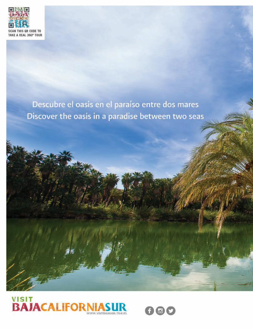
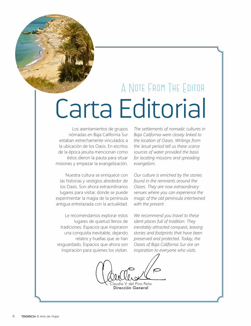
Los asentamientos de grupos nómadas en Baja California Sur estaban estrechamente vinculados a la ubicación de los oasis. En escritos de la época jesuita mencionan como éstos dieron la pauta para situar misiones y empezar la evangelización. Nuestra cultura se enriquece con las historias y vestigios alrededor de los oasis. Son ahora extraordinarios lugares para visitar, donde se puede experimentar la magia de la península antigua entrelazada con la actualidad. Le recomendamos explorar estos lugares de quietud llenos de tradiciones. Espacios que inspiraron una conquista inevitable, dejando relatos y huellas que se han resguardado. Espacios que ahora son inspiración para quienes los visitan.TRANSCRIPT
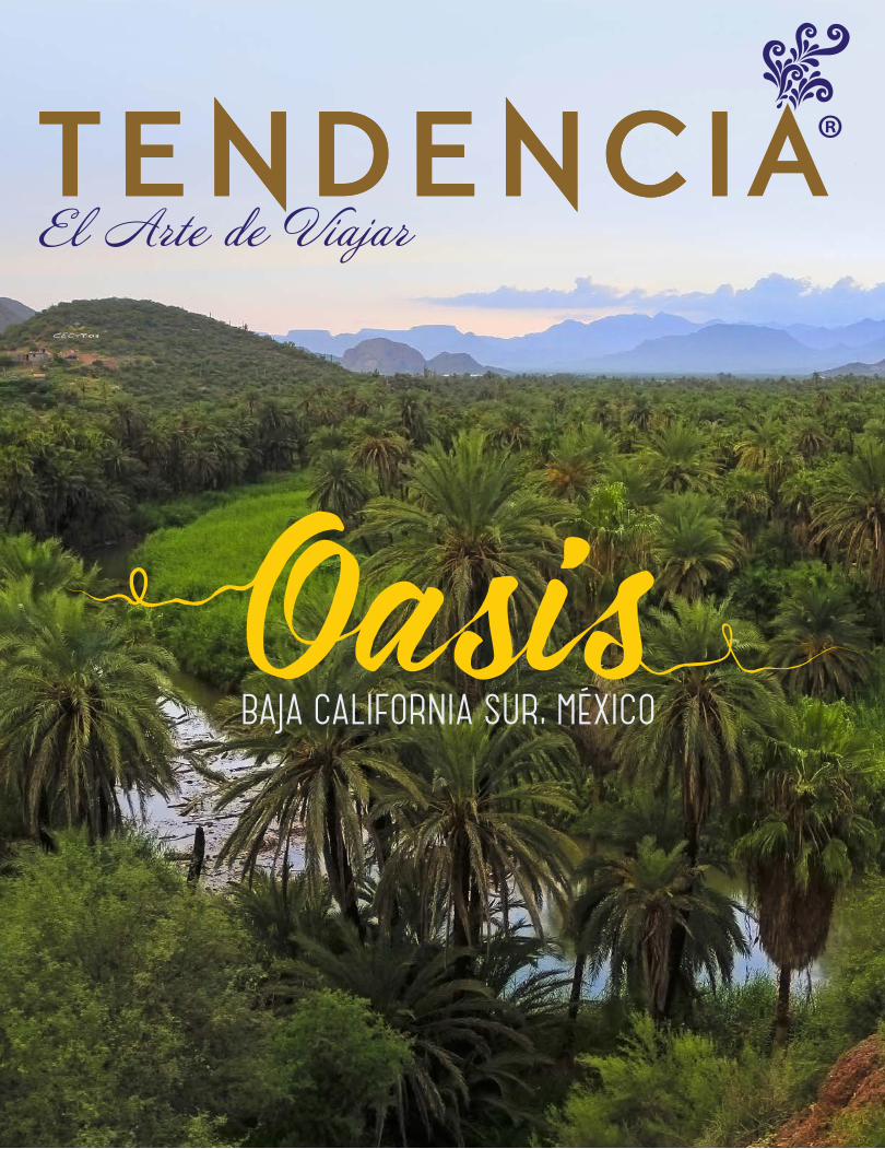
BAJA CALIFORNIA SUR, MÉXICO
TENDENCIA EL ARTE DE VIAJAR, Año 2014, No. 22, septiembre a octubre, es una publicación bimestral editada por Pleamar Cultural, S. de R.L. de C.V., Hidalgo S/N Local 3 entre V. Carranza y A. Obregón, Col. Matamoros, Cabo San Lucas, Baja California Sur, CP 23468, teléfono (624) 104-3516, http://www.tendenciamagazine.com/. Editor responsable: Claudia Veronica del Pino Peña. Reservas de Derechos al Uso Exclusivo No. 04-2012-101712221000-102. ISSN: En trámite; ambos otorgados por el Instituto Nacional del Derecho de Autor. Licitud de Título y Contenido No. 15906, otorgado por la Comisión Calificadora de Publicaciones y Revistas Ilustradas de la Secretaría de Gobernación. Impresa por CARMONA IMPRESORES, S.A. de C.V., Calz. Lázaro Cárdenas No. 850, Col. Eduardo Guerra, Torreón Coah. CP 27280.

A Note From The Editor
Los asentamientos de grupos nómadas en Baja California Sur
estaban estrechamente vinculados a la ubicación de los Oasis. En escritos de la época jesuita mencionan como
éstos dieron la pauta para situar misiones y empezar la evangelización.
Nuestra cultura se enriquece con las historias y vestigios alrededor de los Oasis. Son ahora extraordinarios lugares para visitar, donde se puede
experimentar la magia de la península antigua entrelazada con la actualidad.
Le recomendamos explorar estos lugares de quietud llenos de
tradiciones. Espacios que inspiraron una conquista inevitable, dejando
relatos y huellas que se han resguardado. Espacios que ahora son
inspiración para quienes los visitan.
The settlements of nomadic cultures in Baja California were closely linked to the location of Oases. Writings from the Jesuit period tell us these scarce sources of water provided the basis for locating missions and spreading evangelism.
Our culture is enriched by the stories found in the remnants around the Oases. They are now extraordinary venues where you can experience the magic of the old peninsula intertwined with the present.
We recommend you travel to these silent places full of tradition. They inevitably attracted conquest, leaving stories and footprints that have been preserved and protected. Today, the Oases of Baja California Sur are an inspiration to everyone who visits.
Claudia V. del Pino PeñaDirección General
Carta Editorial
Tendencia El Arte de Viajar6

COLABORADORESGUEST CONTRIBUTORS
Armando Figaredo CantúCristina Rodríguez Bremer
Enrique HambletonFernando Azcona Lizárraga
Gabriel Fonseca VerdugoHarumi Fujita
Jesús Manuel Corral GonzálezOscar Ortiz GarcíaRicardo AmpudiaSeverino GómezYandi Monardo
CONSEJO EDITORIALEDITORIAL BOARD
Laura G. Bueno Michael KohenMaria ElenaMuriel
LeonardoReyes Silva
Jesús Manuel Corral González
Gabriel FonsecaVerdugo
José Martín Olmos Ceseña
Eligio Moisés Coronado
Tendencia El Arte de Viajar8
ViajandoTravelingJesús Corral
La Entrevista InterviewRicardo Rodríguez Estrella
El Estero Josefino, oasis sudcalfonianoGabriel Fonseca
El Gallito MarinoMaría Elena Muriel
Tierra PerfumadaScented SoilJosé Martín Olmos Ceseña
Alonso MencosHotel Marina
CONTENIDO
12
12
18
44
18
71
22
32
36
47
32
Tendencia El Arte de Viajar10
CONTENT
48
47
55
66
71
72
76
Portada / CoverErnesto López
Literatura CalifornianaCalifornian Literature
Un Relato del Escritorio de Laura G. BuenoA Story from the Desk of Laura G. Bueno
Islas SudcalifornianasEligio Moisés Coronado
Vive La ExperienciaLive The ExperienceMichael Kohen
LeyendaLegend
Baja California Sur
Destino InvitadoGuest Destination
11Tendencia El Arte de Viajar
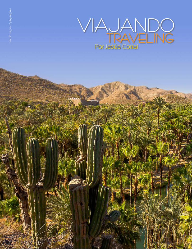
Foto:
© ad
og.m
x / by
Alep
h Alig
hieri
VIAJANDO - TRAVELINGTendencia El Arte de Viajar12
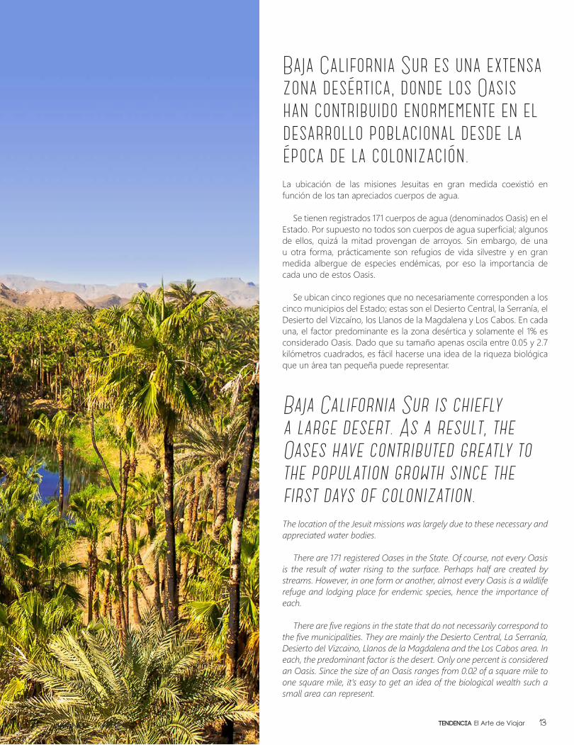
Baja California Sur es una extensa zona desértica, donde los Oasis han contribuido enormemente en el desarrollo poblacional desde la época de la colonización.La ubicación de las misiones Jesuitas en gran medida coexistió en función de los tan apreciados cuerpos de agua.
Se tienen registrados 171 cuerpos de agua (denominados Oasis) en el Estado. Por supuesto no todos son cuerpos de agua superficial; algunos de ellos, quizá la mitad provengan de arroyos. Sin embargo, de una u otra forma, prácticamente son refugios de vida silvestre y en gran medida albergue de especies endémicas, por eso la importancia de cada uno de estos Oasis.
Se ubican cinco regiones que no necesariamente corresponden a los cinco municipios del Estado; estas son el Desierto Central, la Serranía, el Desierto del Vizcaíno, los Llanos de la Magdalena y Los Cabos. En cada una, el factor predominante es la zona desértica y solamente el 1% es considerado Oasis. Dado que su tamaño apenas oscila entre 0.05 y 2.7 kilómetros cuadrados, es fácil hacerse una idea de la riqueza biológica que un área tan pequeña puede representar.
Baja California Sur is chiefly a large desert. As a result, the Oases have contributed greatly to the population growth since the first days of colonization.The location of the Jesuit missions was largely due to these necessary and appreciated water bodies.
There are 171 registered Oases in the State. Of course, not every Oasis is the result of water rising to the surface. Perhaps half are created by streams. However, in one form or another, almost every Oasis is a wildlife refuge and lodging place for endemic species, hence the importance of each.
There are five regions in the state that do not necessarily correspond to the five municipalities. They are mainly the Desierto Central, La Serranía, Desierto del Vizcaino, Llanos de la Magdalena and the Los Cabos area. In each, the predominant factor is the desert. Only one percent is considered an Oasis. Since the size of an Oasis ranges from 0.02 of a square mile to one square mile, it’s easy to get an idea of the biological wealth such a small area can represent.
VIAJANDO - TRAVELING 13Tendencia El Arte de Viajar
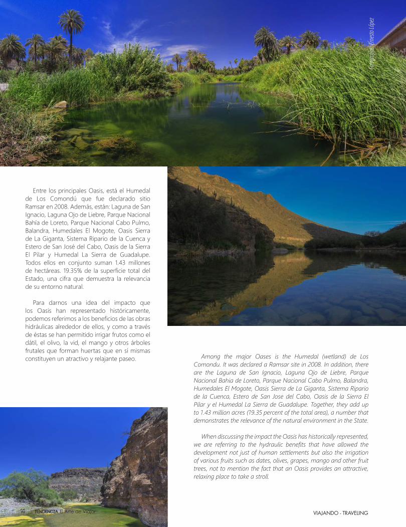
Entre los principales Oasis, está el Humedal de Los Comondú que fue declarado sitio Ramsar en 2008. Además, están: Laguna de San Ignacio, Laguna Ojo de Liebre, Parque Nacional Bahía de Loreto, Parque Nacional Cabo Pulmo, Balandra, Humedales El Mogote, Oasis Sierra de La Giganta, Sistema Ripario de la Cuenca y Estero de San José del Cabo, Oasis de la Sierra El Pilar y Humedal La Sierra de Guadalupe. Todos ellos en conjunto suman 1.43 millones de hectáreas. 19.35% de la superficie total del Estado, una cifra que demuestra la relevancia de su entorno natural.
Para darnos una idea del impacto que los Oasis han representado históricamente, podemos referimos a los beneficios de las obras hidráulicas alrededor de ellos, y como a través de éstas se han permitido irrigar frutos como el dátil, el olivo, la vid, el mango y otros árboles frutales que forman huertas que en sí mismas constituyen un atractivo y relajante paseo. Among the major Oases is the Humedal (wetland) de Los
Comondu. It was declared a Ramsar site in 2008. In addition, there are the Laguna de San Ignacio, Laguna Ojo de Liebre, Parque Nacional Bahia de Loreto, Parque Nacional Cabo Pulmo, Balandra, Humedales El Mogote, Oasis Sierra de La Giganta, Sistema Ripario de la Cuenca, Estero de San Jose del Cabo, Oasis de la Sierra El Pilar y el Humedal La Sierra de Guadalupe. Together, they add up to 1.43 million acres (19.35 percent of the total area), a number that demonstrates the relevance of the natural environment in the State.
When discussing the impact the Oasis has historically represented, we are referring to the hydraulic benefits that have allowed the development not just of human settlements but also the irrigation of various fruits such as dates, olives, grapes, mango and other fruit trees, not to mention the fact that an Oasis provides an attractive, relaxing place to take a stroll.
Fotog
rafía
s: Erne
sto Ló
pez
VIAJANDO - TRAVELINGTendencia El Arte de Viajar14
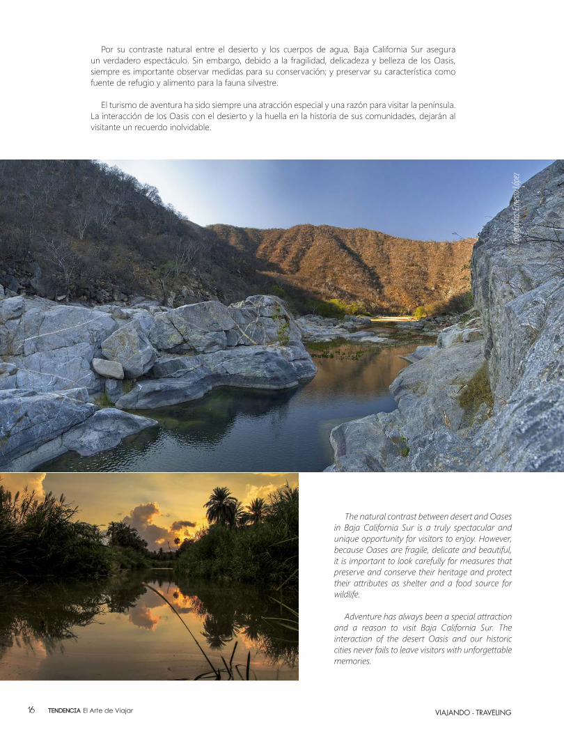
The natural contrast between desert and Oases in Baja California Sur is a truly spectacular and unique opportunity for visitors to enjoy. However, because Oases are fragile, delicate and beautiful, it is important to look carefully for measures that preserve and conserve their heritage and protect their attributes as shelter and a food source for wildlife.
Adventure has always been a special attraction and a reason to visit Baja California Sur. The interaction of the desert Oasis and our historic cities never fails to leave visitors with unforgettable memories.
Por su contraste natural entre el desierto y los cuerpos de agua, Baja California Sur asegura un verdadero espectáculo. Sin embargo, debido a la fragilidad, delicadeza y belleza de los Oasis, siempre es importante observar medidas para su conservación; y preservar su característica como fuente de refugio y alimento para la fauna silvestre.
El turismo de aventura ha sido siempre una atracción especial y una razón para visitar la península. La interacción de los Oasis con el desierto y la huella en la historia de sus comunidades, dejarán al visitante un recuerdo inolvidable.
Fotog
rafía
s: Erne
sto Ló
pez
VIAJANDO - TRAVELINGTendencia El Arte de Viajar16
LA ENTREVISTA - INTERVIEW
RICARDORICARDO EstrellaRodríguez EstrellaRodríguez
Tendencia El Arte de Viajar18
LA ENTREVISTA - INTERVIEW
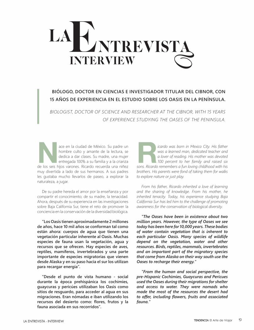
Nace en la ciudad de México. Su padre un hombre culto y amante de la lectura, se dedica a dar clases. Su madre, una mujer entregada 100% a su familia y a la crianza
de los seis hijos varones. Ricardo recuerda una niñez muy divertida a lado de sus hermanos. A sus padres les gustaba mucho llevarlos de paseo, a explorar la naturaleza, a jugar.
De su padre hereda el amor por la enseñanza y por compartir el conocimiento; de su madre, la tenacidad. Ahora, después de su experiencia en las investigaciones sobre Baja California Sur, tiene el reto de promover la conciencia en la conservación de la diversidad biológica.
“Los Oasis tienen aproximadamente 2 millones de años, hace 10 mil años se conforman tal como están ahora: cuerpos de agua que tienen una vegetación particular inherente al Oasis. Muchas especies de fauna usan la vegetación, agua y recursos que se ofrecen. Hay especies de aves, reptiles, mamíferos, invertebrados y una parte importante de especies migratorias que vienen desde Alaska y en su paso hacia el sur los utilizan para recargar energía”.
“Desde el punto de vista humano - social durante la época prehispánica los cochimíes, guaycuras y pericúes utilizaban los Oasis como sitios de resguardo, para acceder al agua en sus migraciones. Eran nómadas e iban utilizando los recursos del desierto como: flores, frutos y la fauna asociada en sus recorridos”.
BIÓLOGO, DOCTOR EN CIENCIAS E INVESTIGADOR TITULAR DEL CIBNOR, CON 15 AÑOS DE EXPERIENCIA EN EL ESTUDIO SOBRE LOS OASIS EN LA PENÍNSULA.
BIOLOGIST, DOCTOR OF SCIENCE AND RESEARCHER AT THE CIBNOR, WITH 15 YEARS
OF EXPERIENCE STUDYING THE OASES OF THE PENINSULA.
Ricardo was born in Mexico City. His father was a learned man, dedicated teacher and a lover of reading. His mother was devoted 100 percent to her family and raised six
sons. Ricardo remembers a fun loving childhood with his brothers. His parents were fond of taking them for walks to explore nature or just play.
From his father, Ricardo inherited a love of learning and the sharing of knowledge. From his mother, he inherited tenacity. Today, his experience studying Baja California Sur has led him to the challenge of promoting awareness for the conservation of biological diversity.
"The Oases have been in existence about two million years. However, the type of Oases we see today has been here for 10,000 years. These bodies of water contain vegetation that is inherent to each particular Oasis. Many species of wildlife depend on the vegetation, water and other resources. Birds, reptiles, mammals, invertebrates and an important part of the migratory species that come from Alaska on their way south use the Oases to recharge their energy."
"From the human and social perspective, the pre-Hispanic Cochimies, Guaycuras and Pericues used the Oases during their migrations for shelter and access to water. They were nomads who made the most of the resources the desert had to offer, including flowers, fruits and associated fauna."
19Tendencia El Arte de Viajar
LA ENTREVISTA - INTERVIEW
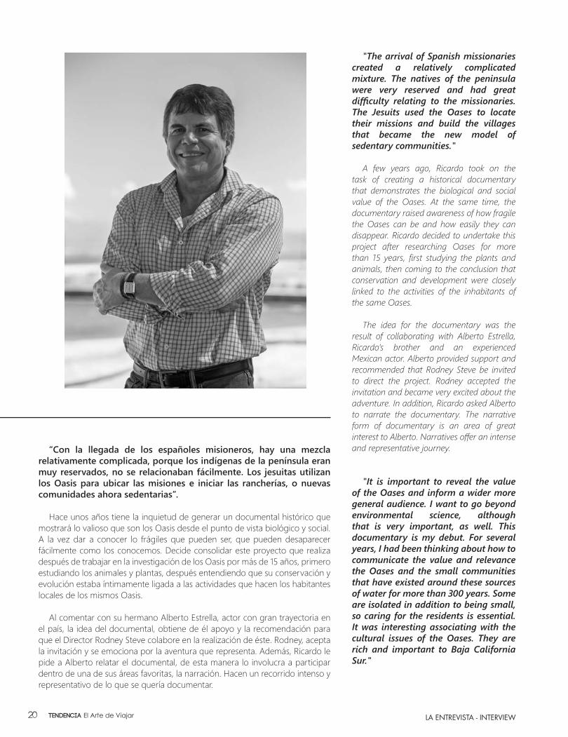
“Con la llegada de los españoles misioneros, hay una mezcla relativamente complicada, porque los indígenas de la península eran muy reservados, no se relacionaban fácilmente. Los jesuitas utilizan los Oasis para ubicar las misiones e iniciar las rancherías, o nuevas comunidades ahora sedentarias”.
Hace unos años tiene la inquietud de generar un documental histórico que mostrará lo valioso que son los Oasis desde el punto de vista biológico y social. A la vez dar a conocer lo frágiles que pueden ser, que pueden desaparecer fácilmente como los conocemos. Decide consolidar este proyecto que realiza después de trabajar en la investigación de los Oasis por más de 15 años, primero estudiando los animales y plantas, después entendiendo que su conservación y evolución estaba íntimamente ligada a las actividades que hacen los habitantes locales de los mismos Oasis.
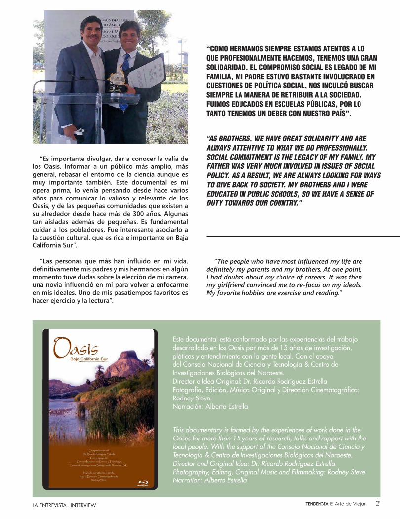
Al comentar con su hermano Alberto Estrella, actor con gran trayectoria en el país, la idea del documental, obtiene de él apoyo y la recomendación para que el Director Rodney Steve colabore en la realización de éste. Rodney, acepta la invitación y se emociona por la aventura que representa. Además, Ricardo le pide a Alberto relatar el documental, de esta manera lo involucra a participar dentro de una de sus áreas favoritas, la narración. Hacen un recorrido intenso y representativo de lo que se quería documentar.
"The arrival of Spanish missionaries created a relatively complicated mixture. The natives of the peninsula were very reserved and had great difficulty relating to the missionaries. The Jesuits used the Oases to locate their missions and build the villages that became the new model of sedentary communities."
A few years ago, Ricardo took on the
task of creating a historical documentary that demonstrates the biological and social value of the Oases. At the same time, the documentary raised awareness of how fragile the Oases can be and how easily they can disappear. Ricardo decided to undertake this project after researching Oases for more than 15 years, first studying the plants and animals, then coming to the conclusion that conservation and development were closely linked to the activities of the inhabitants of the same Oases.
The idea for the documentary was the
result of collaborating with Alberto Estrella, Ricardo’s brother and an experienced Mexican actor. Alberto provided support and recommended that Rodney Steve be invited to direct the project. Rodney accepted the invitation and became very excited about the adventure. In addition, Ricardo asked Alberto to narrate the documentary. The narrative form of documentary is an area of great interest to Alberto. Narratives offer an intense and representative journey.
"It is important to reveal the value of the Oases and inform a wider more general audience. I want to go beyond environmental science, although that is very important, as well. This documentary is my debut. For several years, I had been thinking about how to communicate the value and relevance the Oases and the small communities that have existed around these sources of water for more than 300 years. Some are isolated in addition to being small, so caring for the residents is essential. It was interesting associating with the cultural issues of the Oases. They are rich and important to Baja California Sur."
Tendencia El Arte de Viajar20
LA ENTREVISTA - INTERVIEW
“Es importante divulgar, dar a conocer la valía de los Oasis. Informar a un público más amplio, más general, rebasar el entorno de la ciencia aunque es muy importante también. Este documental es mi opera prima, lo venía pensando desde hace varios años para comunicar lo valioso y relevante de los Oasis, y de las pequeñas comunidades que existen a su alrededor desde hace más de 300 años. Algunas tan aisladas además de pequeñas. Es fundamental cuidar a los pobladores. Fue interesante asociarlo a la cuestión cultural, que es rica e importante en Baja California Sur”.
“Las personas que más han influido en mi vida, definitivamente mis padres y mis hermanos; en algún momento tuve dudas sobre la elección de mi carrera, una novia influenció en mi para volver a enfocarme en mis ideales. Uno de mis pasatiempos favoritos es hacer ejercicio y la lectura”.
"AS BROTHERS, WE HAVE GREAT SOLIDARITY AND ARE ALWAYS ATTENTIVE TO WHAT WE DO PROFESSIONALLY. SOCIAL COMMITMENT IS THE LEGACY OF MY FAMILY. MY FATHER WAS VERY MUCH INVOLVED IN ISSUES OF SOCIAL POLICY. AS A RESULT, WE ARE ALWAYS LOOKING FOR WAYS TO GIVE BACK TO SOCIETY. MY BROTHERS AND I WERE EDUCATED IN PUBLIC SCHOOLS, SO WE HAVE A SENSE OF DUTY TOWARDS OUR COUNTRY."
“COMO HERMANOS SIEMPRE ESTAMOS ATENTOS A LO QUE PROFESIONALMENTE HACEMOS, TENEMOS UNA GRAN SOLIDARIDAD. EL COMPROMISO SOCIAL ES LEGADO DE MI FAMILIA, MI PADRE ESTUVO BASTANTE INVOLUCRADO EN CUESTIONES DE POLÍTICA SOCIAL, NOS INCULCÓ BUSCAR SIEMPRE LA MANERA DE RETRIBUIR A LA SOCIEDAD. FUIMOS EDUCADOS EN ESCUELAS PÚBLICAS, POR LO TANTO TENEMOS UN DEBER CON NUESTRO PAÍS”.
Este documental está conformado por las experiencias del trabajo desarrollado en los Oasis por más de 15 años de investigación, pláticas y entendimiento con la gente local. Con el apoyo del Consejo Nacional de Ciencia y Tecnología & Centro de Investigaciones Biológicas del Noroeste.Director e Idea Original: Dr. Ricardo Rodríguez EstrellaFotografía, Edición, Música Original y Dirección Cinematográfica: Rodney Steve.Narración: Alberto Estrella
This documentary is formed by the experiences of work done in the Oases for more than 15 years of research, talks and rapport with the local people. With the support of the Consejo Nacional de Ciencia y Tecnología & Centro de Investigaciones Biológicas del Noroeste.Director and Original Idea: Dr. Ricardo Rodríguez EstrellaPhotography, Editing, Original Music and Filmmaking: Rodney SteveNarration: Alberto Estrella
“The people who have most influenced my life are definitely my parents and my brothers. At one point, I had doubts about my choice of careers. It was then my girlfriend convinced me to re-focus on my ideals. My favorite hobbies are exercise and reading.”
21Tendencia El Arte de Viajar
GABRIEL FONSECA
www.gabrielfonseca.mx
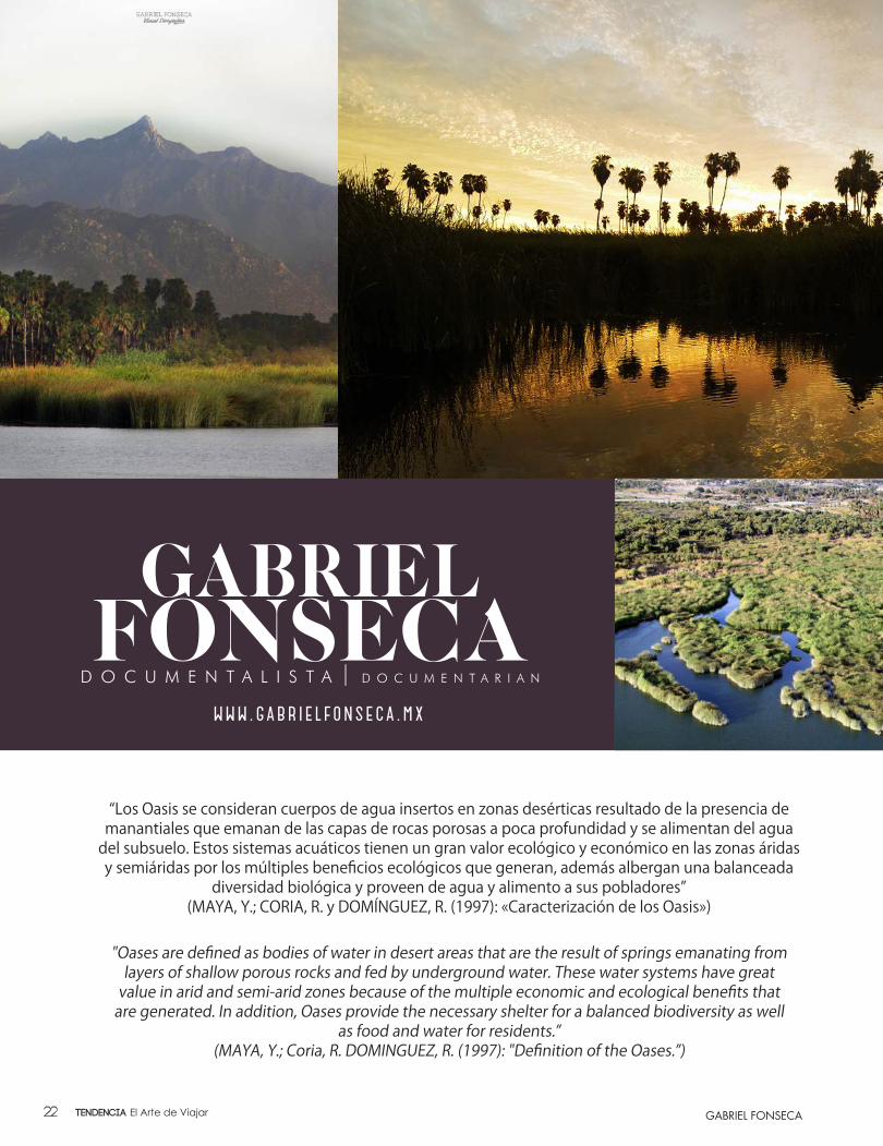
“Los Oasis se consideran cuerpos de agua insertos en zonas desérticas resultado de la presencia de manantiales que emanan de las capas de rocas porosas a poca profundidad y se alimentan del agua
del subsuelo. Estos sistemas acuáticos tienen un gran valor ecológico y económico en las zonas áridas y semiáridas por los múltiples beneficios ecológicos que generan, además albergan una balanceada
diversidad biológica y proveen de agua y alimento a sus pobladores”(MAYA, Y.; CORIA, R. y DOMÍNGUEZ, R. (1997): «Caracterización de los Oasis»)
"Oases are defined as bodies of water in desert areas that are the result of springs emanating from layers of shallow porous rocks and fed by underground water. These water systems have great
value in arid and semi-arid zones because of the multiple economic and ecological benefits that are generated. In addition, Oases provide the necessary shelter for a balanced biodiversity as well
as food and water for residents.”(MAYA, Y.; Coria, R. DOMINGUEZ, R. (1997): "Definition of the Oases.”)
Tendencia El Arte de Viajar22
GABRIEL FONSECA
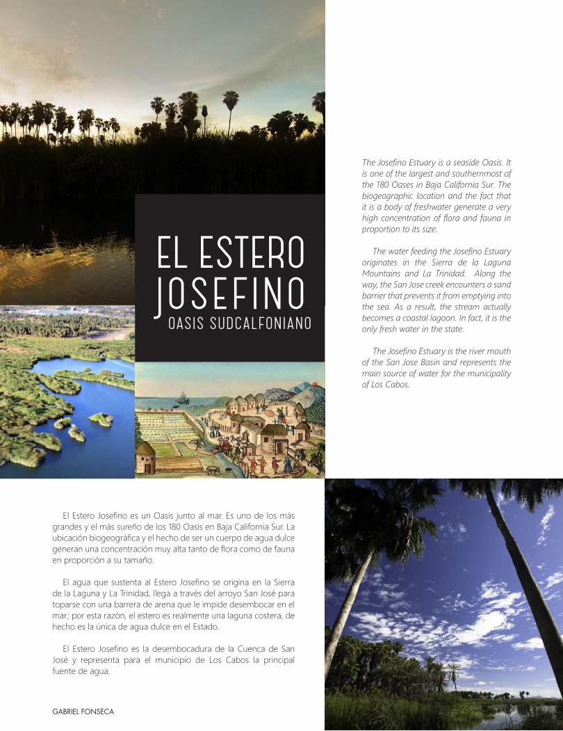
The Josefino Estuary is a seaside Oasis. It is one of the largest and southernmost of the 180 Oases in Baja California Sur. The biogeographic location and the fact that it is a body of freshwater generate a very high concentration of flora and fauna in proportion to its size.
The water feeding the Josefino Estuary originates in the Sierra de la Laguna Mountains and La Trinidad. Along the way, the San Jose creek encounters a sand barrier that prevents it from emptying into the sea. As a result, the stream actually becomes a coastal lagoon. In fact, it is the only fresh water in the state.
The Josefino Estuary is the river mouth of the San Jose Basin and represents the main source of water for the municipality of Los Cabos.
El Estero Josefino es un Oasis junto al mar. Es uno de los más grandes y el más sureño de los 180 Oasis en Baja California Sur. La ubicación biogeográfica y el hecho de ser un cuerpo de agua dulce generan una concentración muy alta tanto de flora como de fauna en proporción a su tamaño.
El agua que sustenta al Estero Josefino se origina en la Sierra de la Laguna y La Trinidad, llega a través del arroyo San José para toparse con una barrera de arena que le impide desembocar en el mar; por esta razón, el estero es realmente una laguna costera, de hecho es la única de agua dulce en el Estado.
El Estero Josefino es la desembocadura de la Cuenca de San José y representa para el municipio de Los Cabos la principal fuente de agua.
OASIS SUDCALFONIANO
EL ESTERO JOSEFINO
23Tendencia El Arte de Viajar
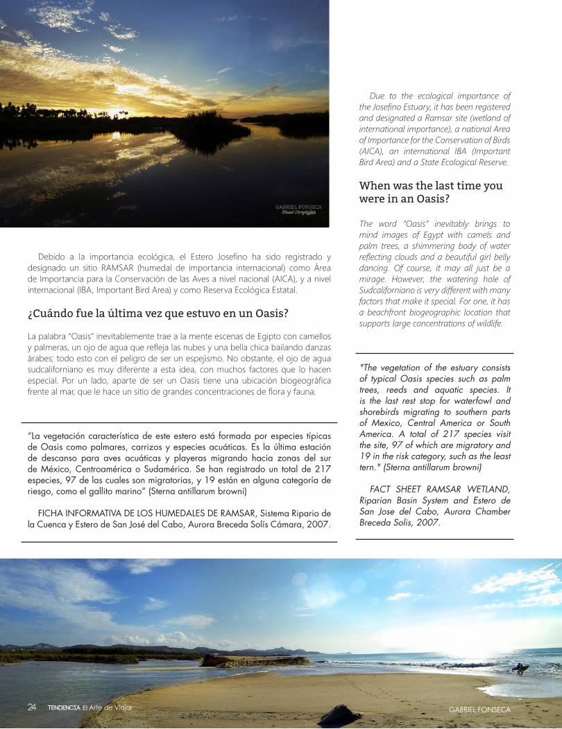
Debido a la importancia ecológica, el Estero Josefino ha sido registrado y designado un sitio RAMSAR (humedal de importancia internacional) como Área de Importancia para la Conservación de las Aves a nivel nacional (AICA), y a nivel internacional (IBA, Important Bird Area) y como Reserva Ecológica Estatal.
¿Cuándo fue la última vez que estuvo en un Oasis?
La palabra “Oasis” inevitablemente trae a la mente escenas de Egipto con camellos y palmeras, un ojo de agua que refleja las nubes y una bella chica bailando danzas árabes; todo esto con el peligro de ser un espejismo. No obstante, el ojo de agua sudcaliforniano es muy diferente a esta idea, con muchos factores que lo hacen especial. Por un lado, aparte de ser un Oasis tiene una ubicación biogeográfica frente al mar, que le hace un sitio de grandes concentraciones de flora y fauna.
“La vegetación característica de este estero está formada por especies típicas de Oasis como palmares, carrizos y especies acuáticas. Es la última estación de descanso para aves acuáticas y playeras migrando hacia zonas del sur de México, Centroamérica o Sudamérica. Se han registrado un total de 217 especies, 97 de las cuales son migratorias, y 19 están en alguna categoría de riesgo, como el gallito marino” (Sterna antillarum browni)
FICHA INFORMATIVA DE LOS HUMEDALES DE RAMSAR, Sistema Ripario de la Cuenca y Estero de San José del Cabo, Aurora Breceda Solís Cámara, 2007.
Due to the ecological importance of the Josefino Estuary, it has been registered and designated a Ramsar site (wetland of international importance), a national Area of Importance for the Conservation of Birds (AICA), an international IBA (Important Bird Area) and a State Ecological Reserve.
When was the last time you were in an Oasis?
The word “Oasis” inevitably brings to mind images of Egypt with camels and palm trees, a shimmering body of water reflecting clouds and a beautiful girl belly dancing. Of course, it may all just be a mirage. However, the watering hole of Sudcaliforniano is very different with many factors that make it special. For one, it has a beachfront biogeographic location that supports large concentrations of wildlife.
"The vegetation of the estuary consists of typical Oasis species such as palm trees, reeds and aquatic species. It is the last rest stop for waterfowl and shorebirds migrating to southern parts of Mexico, Central America or South America. A total of 217 species visit the site, 97 of which are migratory and 19 in the risk category, such as the least tern." (Sterna antillarum browni)
FACT SHEET RAMSAR WETLAND, Riparian Basin System and Estero de San Jose del Cabo, Aurora Chamber Breceda Solis, 2007.
GABRIEL FONSECATendencia El Arte de Viajar24
GABRIEL FONSECA
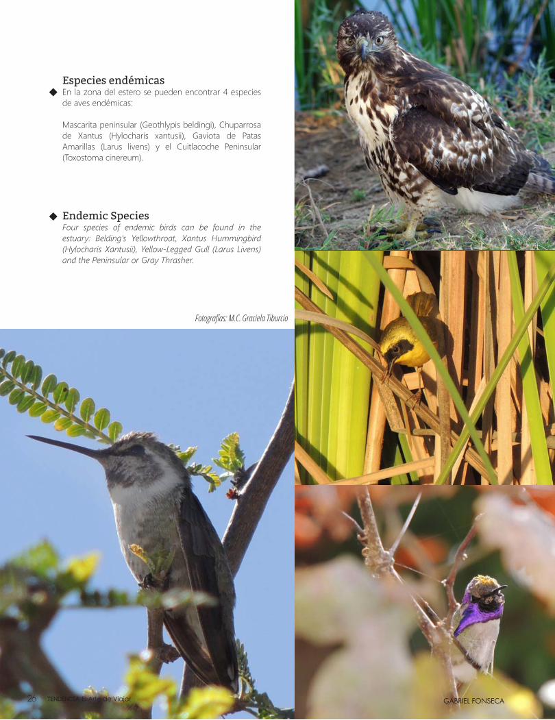
Especies endémicasEn la zona del estero se pueden encontrar 4 especies de aves endémicas:
Mascarita peninsular (Geothlypis beldingi), Chuparrosa de Xantus (Hylocharis xantusii), Gaviota de Patas Amarillas (Larus livens) y el Cuitlacoche Peninsular (Toxostoma cinereum).
Endemic SpeciesFour species of endemic birds can be found in the estuary: Belding's Yellowthroat, Xantus Hummingbird (Hylocharis Xantusii), Yellow-Legged Gull (Larus Livens) and the Peninsular or Gray Thrasher.
Fotografías: M.C. Graciela Tiburcio
Tendencia El Arte de Viajar26
Los Cabos’ Best Kept Secret...Los Cabos’ Best Kept Secret...
Lada sin costo MX 01 800 942 2436 - Toll Free 1855 484 4790 - Tel. (624) 163 5550 - For Groups & Weddings 1 877 319 5080
xperimenta al máximo el latido, los colores y sabores de México en un hotel estilo hacienda mexicana contemporánea ubicado en el maravilloso Corredor turístico de Los Cabos que le ofrece
majestuosas vistas al Mar de Cortés y “Land’s End”, amplias suites de lujo, restaurantes gourmet, relajantes albercas y variedad de locaciones para eventos especiales.
xperience the beat, colors and flavors of traditional Mexico in a contemporary hacienda-style resort. Hacienda Encantada is blessed with a breathtaking Los Cabos location offering majestic
views of the Sea of Cortes and the Land’s End of the Baja Peninsula. Enjoy spacious suites, gourmet dining, luxurious pools and a choice of beautiful settings for special events.
www.haciendaencantada.com
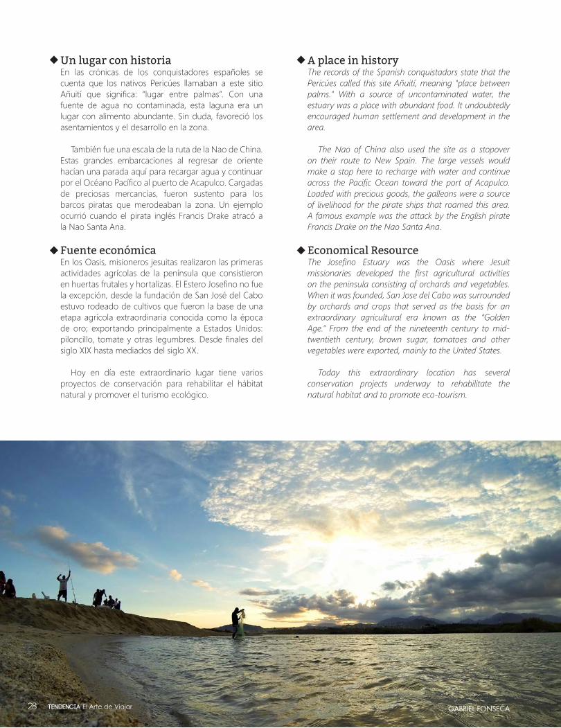
Un lugar con historiaEn las crónicas de los conquistadores españoles se cuenta que los nativos Pericúes llamaban a este sitio Añuití que significa: “lugar entre palmas”. Con una fuente de agua no contaminada, esta laguna era un lugar con alimento abundante. Sin duda, favoreció los asentamientos y el desarrollo en la zona.
También fue una escala de la ruta de la Nao de China. Estas grandes embarcaciones al regresar de oriente hacían una parada aquí para recargar agua y continuar por el Océano Pacífico al puerto de Acapulco. Cargadas de preciosas mercancías, fueron sustento para los barcos piratas que merodeaban la zona. Un ejemplo ocurrió cuando el pirata inglés Francis Drake atracó a la Nao Santa Ana.
Fuente económica En los Oasis, misioneros jesuitas realizaron las primeras actividades agrícolas de la península que consistieron en huertas frutales y hortalizas. El Estero Josefino no fue la excepción, desde la fundación de San José del Cabo estuvo rodeado de cultivos que fueron la base de una etapa agrícola extraordinaria conocida como la época de oro; exportando principalmente a Estados Unidos: piloncillo, tomate y otras legumbres. Desde finales del siglo XIX hasta mediados del siglo XX.
Hoy en día este extraordinario lugar tiene varios proyectos de conservación para rehabilitar el hábitat natural y promover el turismo ecológico.
A place in historyThe records of the Spanish conquistadors state that the Pericúes called this site Añuití, meaning "place between palms." With a source of uncontaminated water, the estuary was a place with abundant food. It undoubtedly encouraged human settlement and development in the area.
The Nao of China also used the site as a stopover on their route to New Spain. The large vessels would make a stop here to recharge with water and continue across the Pacific Ocean toward the port of Acapulco. Loaded with precious goods, the galleons were a source of livelihood for the pirate ships that roamed this area. A famous example was the attack by the English pirate Francis Drake on the Nao Santa Ana.
Economical ResourceThe Josefino Estuary was the Oasis where Jesuit missionaries developed the first agricultural activities on the peninsula consisting of orchards and vegetables. When it was founded, San Jose del Cabo was surrounded by orchards and crops that served as the basis for an extraordinary agricultural era known as the “Golden Age.” From the end of the nineteenth century to mid-twentieth century, brown sugar, tomatoes and other vegetables were exported, mainly to the United States.
Today this extraordinary location has several conservation projects underway to rehabilitate the natural habitat and to promote eco-tourism.
GABRIEL FONSECATendencia El Arte de Viajar28


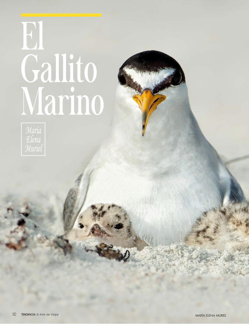
El Gallito Marino
María Elena Muriel
MARÍA ELENA MURIELTendencia El Arte de Viajar32
Large numbers of birds move across our continent and some are 100 percent Baja Californian. We always have these birds. They visit us for days to rest, feed and regain their energy to once again take flight. Or, like some birds, the attractive conditions offered by the peninsula make our region their final destination.
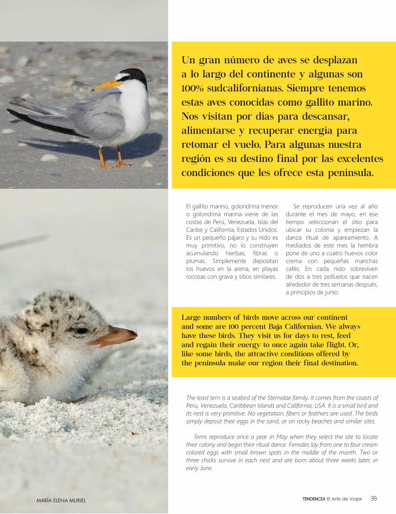
Un gran número de aves se desplazan a lo largo del continente y algunas son 100% sudcalifornianas. Siempre tenemos estas aves conocidas como gallito marino. Nos visitan por días para descansar, alimentarse y recuperar energía para retomar el vuelo. Para algunas nuestra región es su destino final por las excelentes condiciones que les ofrece esta península.
El gallito marino, golondrina menor o golondrina marina viene de las costas de Perú, Venezuela, Islas del Caribe y California, Estados Unidos. Es un pequeño pájaro y su nido es muy primitivo, no lo construyen acumulando hierbas, fibras o plumas. Simplemente depositan los huevos en la arena, en playas rocosas con grava y sitios similares.
Se reproducen una vez al año durante el mes de mayo, en ese tiempo seleccionan el sitio para ubicar su colonia y empiezan la danza ritual de apareamiento. A mediados de este mes la hembra pone de uno a cuatro huevos color crema con pequeñas manchas cafés. En cada nido sobreviven de dos a tres polluelos que nacen alrededor de tres semanas después, a principios de junio.
The least tern is a seabird of the Sternidae family. It comes from the coasts of Peru, Venezuela, Caribbean Islands and California, USA. It is a small bird and its nest is very primitive. No vegetation, fibers or feathers are used. The birds simply deposit their eggs in the sand, or on rocky beaches and similar sites.
Terns reproduce once a year in May when they select the site to locate their colony and begin their ritual dance. Females lay from one to four cream colored eggs with small brown spots in the middle of the month. Two or three chicks survive in each nest and are born about three weeks later, in early June.
MARÍA ELENA MURIEL 33Tendencia El Arte de Viajar
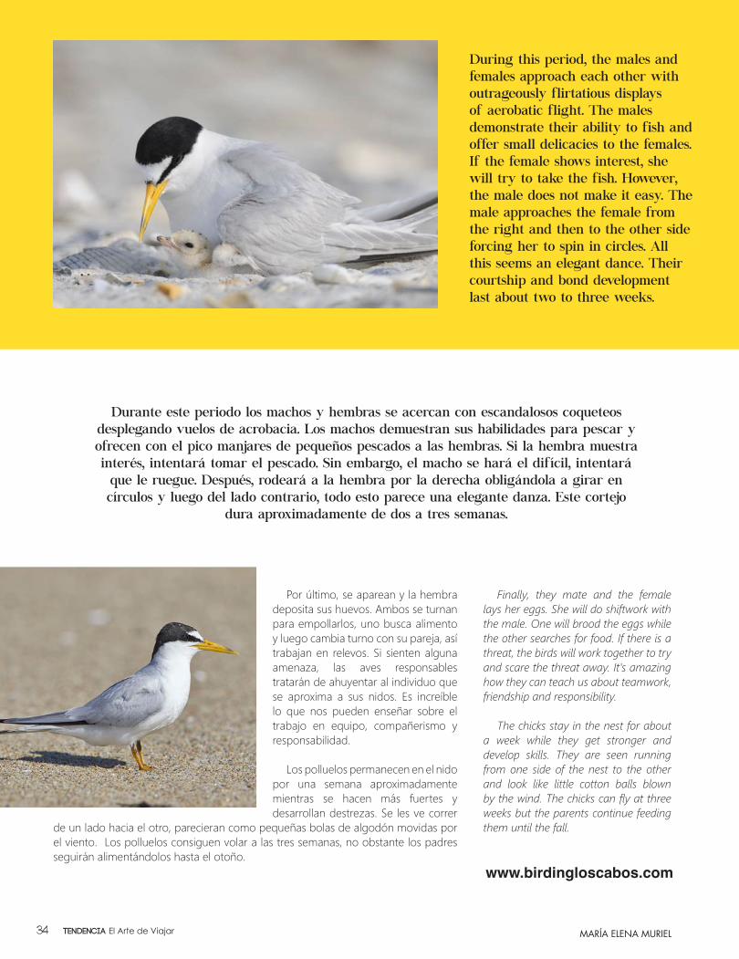
Por último, se aparean y la hembra deposita sus huevos. Ambos se turnan para empollarlos, uno busca alimento y luego cambia turno con su pareja, así trabajan en relevos. Si sienten alguna amenaza, las aves responsables tratarán de ahuyentar al individuo que se aproxima a sus nidos. Es increíble lo que nos pueden enseñar sobre el trabajo en equipo, compañerismo y responsabilidad.
Los polluelos permanecen en el nido por una semana aproximadamente mientras se hacen más fuertes y desarrollan destrezas. Se les ve correr
de un lado hacia el otro, parecieran como pequeñas bolas de algodón movidas por el viento. Los polluelos consiguen volar a las tres semanas, no obstante los padres seguirán alimentándolos hasta el otoño.
Finally, they mate and the female lays her eggs. She will do shiftwork with the male. One will brood the eggs while the other searches for food. If there is a threat, the birds will work together to try and scare the threat away. It's amazing how they can teach us about teamwork, friendship and responsibility.
The chicks stay in the nest for about a week while they get stronger and develop skills. They are seen running from one side of the nest to the other and look like little cotton balls blown by the wind. The chicks can fly at three weeks but the parents continue feeding them until the fall.
www.birdingloscabos.com
Durante este periodo los machos y hembras se acercan con escandalosos coqueteos desplegando vuelos de acrobacia. Los machos demuestran sus habilidades para pescar y ofrecen con el pico manjares de pequeños pescados a las hembras. Si la hembra muestra interés, intentará tomar el pescado. Sin embargo, el macho se hará el difícil, intentará que le ruegue. Después, rodeará a la hembra por la derecha obligándola a girar en círculos y luego del lado contrario, todo esto parece una elegante danza. Este cortejo
dura aproximadamente de dos a tres semanas.
During this period, the males and females approach each other with outrageously flirtatious displays of aerobatic flight. The males demonstrate their ability to fish and offer small delicacies to the females. If the female shows interest, she will try to take the fish. However, the male does not make it easy. The male approaches the female from the right and then to the other side forcing her to spin in circles. All this seems an elegant dance. Their courtship and bond development last about two to three weeks.
MARÍA ELENA MURIELTendencia El Arte de Viajar34
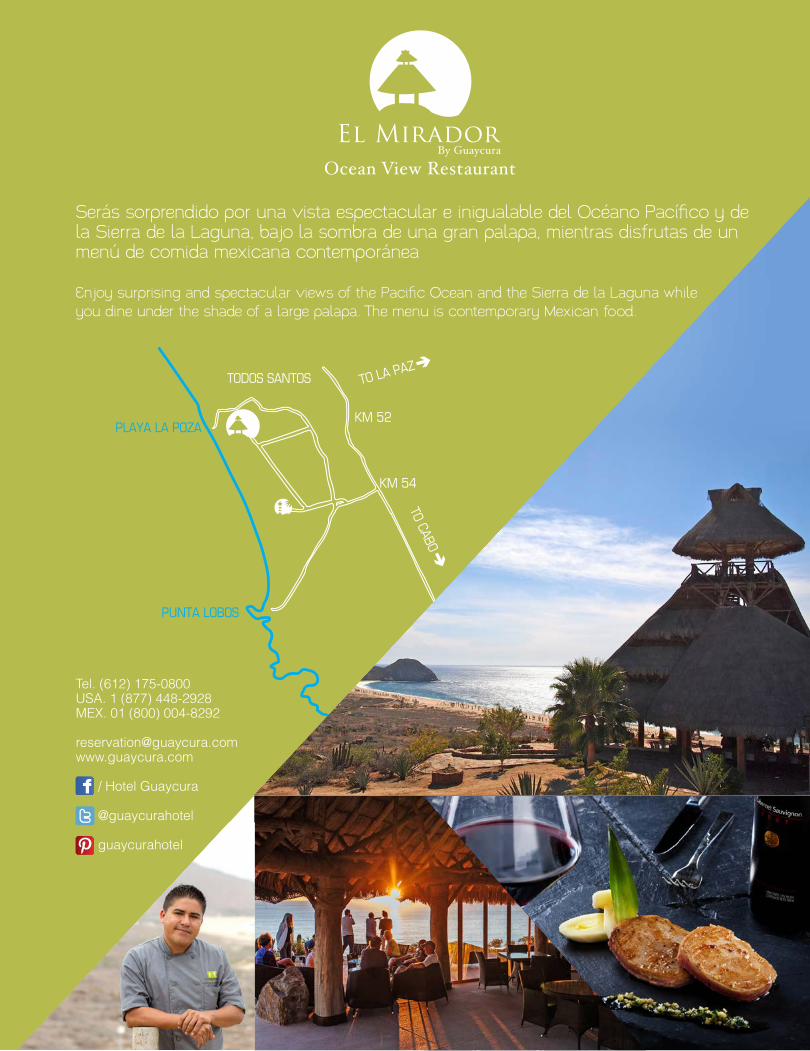
Serás sorprendido por una vista espectacular e inigualable del Océano Pacífico y de la Sierra de la Laguna, bajo la sombra de una gran palapa, mientras disfrutas de un menú de comida mexicana contemporánea
Enjoy surprising and spectacular views of the Pacific Ocean and the Sierra de la Laguna while you dine under the shade of a large palapa. The menu is contemporary Mexican food.
Tel. (612) 175-0800USA. 1 (877) 448-2928MEX. 01 (800) 004-8292
/ Hotel Guaycura
@guaycurahotel
guaycurahotel
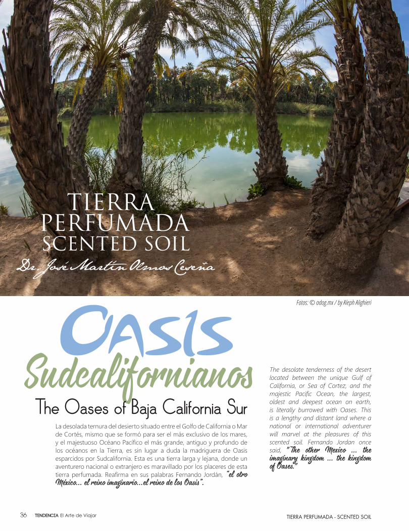
SudcalifornianosLa desolada ternura del desierto situado entre el Golfo de California o Mar de Cortés, mismo que se formó para ser el más exclusivo de los mares, y el majestuoso Océano Pacífico el más grande, antiguo y profundo de los océanos en la Tierra, es sin lugar a duda la madriguera de Oasis esparcidos por Sudcalifornia. Esta es una tierra larga y lejana, donde un aventurero nacional o extranjero es maravillado por los placeres de esta tierra perfumada. Reafirma en sus palabras Fernando Jordán, “el otro
México… el reino imaginario…el reino de los Oasis”.
TIERRA PERFUMADA - SCENTED SOIL
The desolate tenderness of the desert located between the unique Gulf of California, or Sea of Cortez, and the majestic Pacific Ocean, the largest, oldest and deepest ocean on earth, is literally burrowed with Oases. This is a lengthy and distant land where a national or international adventurer will marvel at the pleasures of this scented soil. Fernando Jordan once said, "The other Mexico ... the
imaginary kingdom ... the kingdom
of Oases."
The Oases of Baja California Sur
Fotos: © adog.mx / by Aleph Alighieri
Tendencia El Arte de Viajar36
TIERRA PERFUMADA - SCENTED SOIL
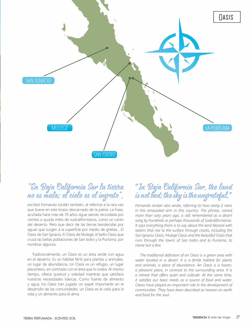
"In Baja California Sur, the land
is not bad; the sky is the ungrateful,"
Fernando Jordan also wrote, referring to how rarely it rains in this emaciated arm in this country. The phrase, coined more than sixty years ago, is still remembered as a desert song by hundreds or perhaps thousands of Sudcalifornianos. It says everything there is to say about the land blessed with waters that rise to the surface through cracks, including the San Ignacio Oasis, Mulege Oasis and the beautiful Oasis that runs through the towns of San Isidro and la Purisima, to name but a few.
The traditional definition of an Oasis is a green area with water located in a desert. It is a fertile habitat for plants and animals, a place of abundance. An Oasis is a haven, a pleasant place, in contrast to the surrounding area. It is a retreat that offers quiet and solitude. At the same time, it satisfies our basic needs as a source of food and water. Oases have played an important role in the development of communities. They have been described as heaven on earth and food for the soul.
“En Baja California Sur la tierra
no es mala; el cielo es el ingrato”,
escribió Fernando Jordán también, al referirse a la rara vez que llueve en este brazo descarnado de la patria. La frase, acuñada hace más de 70 años sigue siendo recordada por cientos o quizás miles de sudcalifornianos, como un canto del desierto. Pero que decir de las tierras bendecidas por aguas que surgen a la superficie por medio de grietas… El Oasis de San Ignacio, El Oasis de Mulegé, el bello Oasis que cruza las bellas poblaciones de San Isidro y la Purísima, por nombrar algunos.
Tradicionalmente, un Oasis es un área verde con agua en el desierto. Es un hábitat fértil para plantas y animales, un lugar de abundancia. Un Oasis es un refugio, un lugar placentero, en contraste con el área que lo rodea. Al mismo tiempo, ofrece quietud y soledad mientras que satisface nuestras necesidades básicas. Como fuente de alimento y agua, los Oasis han jugado un papel importante en el desarrollo de las comunidades, un Oasis es el cielo para la vida y un alimento para el alma.
Oasis
SAN IGNACIO
MULEGÉ
SAN ISIDRO
LA PURÍSIMA
37Tendencia El Arte de Viajar
TIERRA PERFUMADA - SCENTED SOIL
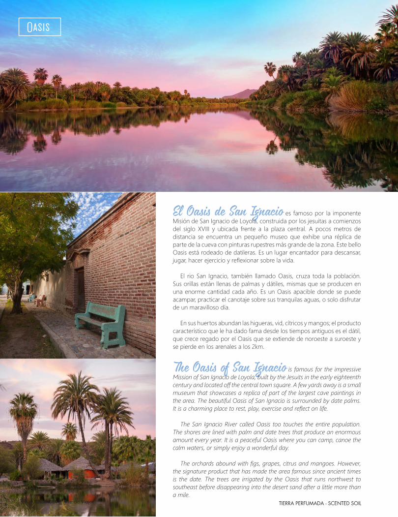
El Oasis de San Ignacio es famoso por la imponente Misión de San Ignacio de Loyola, construida por los jesuitas a comienzos del siglo XVIII y ubicada frente a la plaza central. A pocos metros de distancia se encuentra un pequeño museo que exhibe una réplica de parte de la cueva con pinturas rupestres más grande de la zona. Este bello Oasis está rodeado de datileras. Es un lugar encantador para descansar, jugar, hacer ejercicio y reflexionar sobre la vida.
El rio San Ignacio, también llamado Oasis, cruza toda la población. Sus orillas están llenas de palmas y dátiles, mismas que se producen en una enorme cantidad cada año. Es un Oasis apacible donde se puede acampar, practicar el canotaje sobre sus tranquilas aguas, o solo disfrutar de un maravilloso día.
En sus huertos abundan las higueras, vid, cítricos y mangos; el producto característico que le ha dado fama desde los tiempos antiguos es el dátil, que crece regado por el Oasis que se extiende de noroeste a suroeste y se pierde en los arenales a los 2km.
The Oasis of San Ignacio is famous for the impressive Mission of San Ignacio de Loyola, built by the Jesuits in the early eighteenth century and located off the central town square. A few yards away is a small museum that showcases a replica of part of the largest cave paintings in the area. The beautiful Oasis of San Ignacio is surrounded by date palms. It is a charming place to rest, play, exercise and reflect on life.
The San Ignacio River called Oasis too touches the entire population.
The shores are lined with palm and date trees that produce an enormous amount every year. It is a peaceful Oasis where you can camp, canoe the calm waters, or simply enjoy a wonderful day.
The orchards abound with figs, grapes, citrus and mangoes. However,
the signature product that has made the area famous since ancient times is the date. The trees are irrigated by the Oasis that runs northwest to southeast before disappearing into the desert sand after a little more than a mile.
Oasis
Tendencia El Arte de Viajar38

TIERRA PERFUMADA - SCENTED SOIL
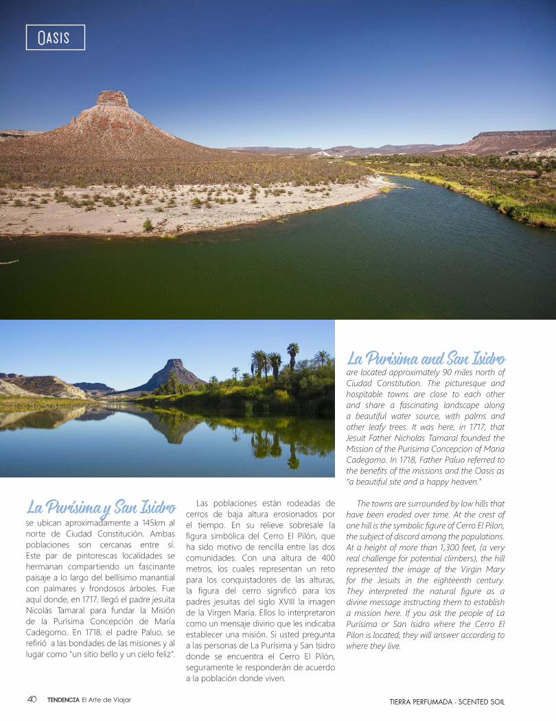
La Purísima y San Isidro se ubican aproximadamente a 145km al norte de Ciudad Constitución. Ambas poblaciones son cercanas entre sí. Este par de pintorescas localidades se hermanan compartiendo un fascinante paisaje a lo largo del bellísimo manantial con palmares y frondosos árboles. Fue aquí donde, en 1717, llegó el padre jesuita Nicolás Tamaral para fundar la Misión de la Purísima Concepción de María Cadegomo. En 1718, el padre Paluo, se refirió a las bondades de las misiones y al lugar como “un sitio bello y un cielo feliz”.
Las poblaciones están rodeadas de cerros de baja altura erosionados por el tiempo. En su relieve sobresale la figura simbólica del Cerro El Pilón, que ha sido motivo de rencilla entre las dos comunidades. Con una altura de 400 metros, los cuales representan un reto para los conquistadores de las alturas, la figura del cerro significó para los padres jesuitas del siglo XVIII la imagen de la Virgen María. Ellos lo interpretaron como un mensaje divino que les indicaba establecer una misión. Si usted pregunta a las personas de La Purísima y San Isidro donde se encuentra el Cerro El Pilón, seguramente le responderán de acuerdo a la población donde viven.
La Purisima and San Isidro are located approximately 90 miles north of Ciudad Constitution. The picturesque and hospitable towns are close to each other and share a fascinating landscape along a beautiful water source, with palms and other leafy trees. It was here, in 1717, that Jesuit Father Nicholas Tamaral founded the Mission of the Purisima Concepcion of Maria Cadegomo. In 1718, Father Paluo referred to the benefits of the missions and the Oasis as “a beautiful site and a happy heaven.”
The towns are surrounded by low hills that
have been eroded over time. At the crest of one hill is the symbolic figure of Cerro El Pilon, the subject of discord among the populations. At a height of more than 1,300 feet, (a very real challenge for potential climbers), the hill represented the image of the Virgin Mary for the Jesuits in the eighteenth century. They interpreted the natural figure as a divine message instructing them to establish a mission here. If you ask the people of La Purisima or San Isidro where the Cerro El Pilon is located, they will answer according to where they live.
Oasis
Tendencia El Arte de Viajar40


TIERRA PERFUMADA - SCENTED SOIL
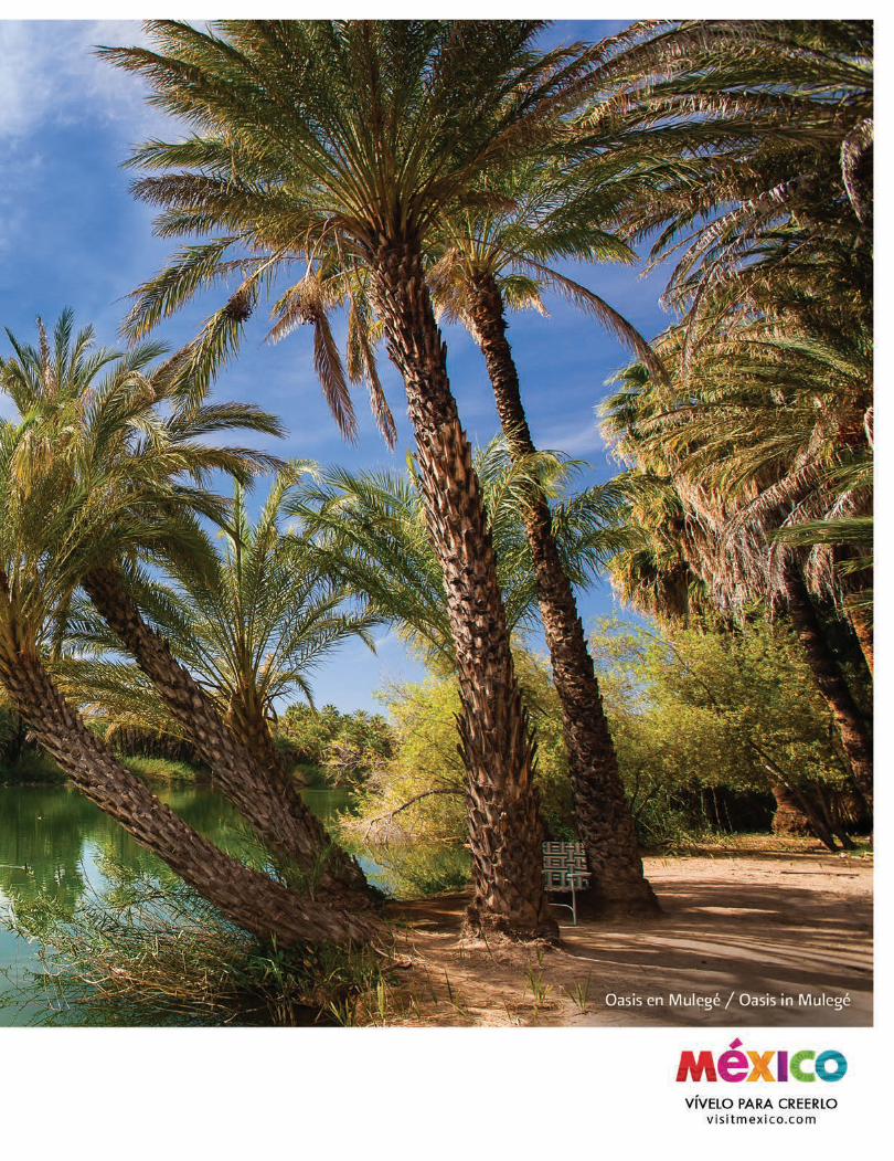
Mulegé es otro Oasis en el desierto. Además de poder realizar numerosas actividades, el lugar invita a conocer los vestigios históricos, para los cuales se coordinan visitas guiadas hacia las pinturas rupestres de La Trinidad y San Borjitas, localizados en las cercanías del poblado.
Como referencia histórica, podemos destacar que fue descubierto en un viaje de exploración durante el año 1702, cuyo protagonista principal fue el padre jesuita Juan María de Salvatierra. Al año siguiente, cuando arribaron al sitio los padres Francisco María Piccolo y Juan María Basaldú, fundaron la misión denominada Santa Rosalía de Mulegé, que se ubica en lo alto de una loma cerca del extenso palmar.
Otro gran atractivo de este Oasis es la cárcel sin puertas. Hoy en día, el edificio histórico es un museo regional, digno de visitar para descubrir algunos misterios de esta localidad. Por otro lado, este Oasis nos da la oportunidad de visitar las playas: Santispac, Requesón, Concepción, Los Cocos, El Burro y El Coyote, que se encuentran a escasos kilómetros del centro de Mulegé.
Mulege is another desert Oasis. In addition to many leisure opportunities, there are historical relics to visit, including tours to the cave paintings of La Trinidad and San Borjitas, located near the village.
For historical significance, we can point out that the site
was discovered on a journey of exploration led by the Jesuit Father Juan Maria de Salvatierra in 1702. The following year, when the Jesuits Francisco Maria Piccolo and Juan Maria Basaldu arrived at the site, the mission called Santa Rosalia of Mulege was founded. It sits atop a hill near an expansive grove of palms.
Another major attraction of this Oasis is the prison with
no doors. Today, the historic building is a regional museum and well worth visiting to uncover some of the mysteries of the town. On the other hand, this beautiful Oasis provides an opportunity to visit the beaches of Santispac, Requeson, Concepcion, Los Cocos, El Burro and El Coyote, located a few miles from downtown Mulege.
Oasis
Los Oasis Sudcalifornianos, son un recorrido que introduce al aventurero en la historia, la evolución y la increíble flora y fauna de cada lugar, además de develar los aspectos sociales y económicos de los habitantes de estos singulares poblados rodeados por maravillosas vistas de palmeras y datileras. Es una escenografía con una belleza natural conservada por el ranchero sudcaliforniano.
Al viajar a través de esta parte de la península, puedes enriquecer la travesía con el avistamiento de ballenas, la visita a una zona de arte rupestre o un safari fotográfico a lo largo de la ruta de las misiones jesuitas.
Sudcalifornia, tierra perfumada, tierra de Oasis, es un destino maravilloso, donde la desolada ternura del desierto increíblemente toca todos los sentidos humanos de quien se atreve a la aventura, a descubrir la magia y una realidad que sobrevive.
The Oases of Baja California Sur is a journey that introduces the adventurer to the history, evolution and the incredible flora and fauna of each location, in addition to highlighting the social and economic aspects of the inhabitants of these unique villages surrounded by stunning views of palm and date palm trees. It is cultural scenery with a characteristic natural beauty that is preserved by the ranchers of Baja California Sur.
When traveling through this part of the peninsula, the
journey can be enriched with whale watching, visiting an area with rock paintings or embarking on a photo safari along the route of the Jesuit missions.
Sudcalifornia, scented soil, Oasis soil, is a wonderful
destination where the desolate tenderness of the desert incredibly touches every human sense and rewards the adventurous with a discovery of magic and reality that continues to survive.
Tendencia El Arte de Viajar42
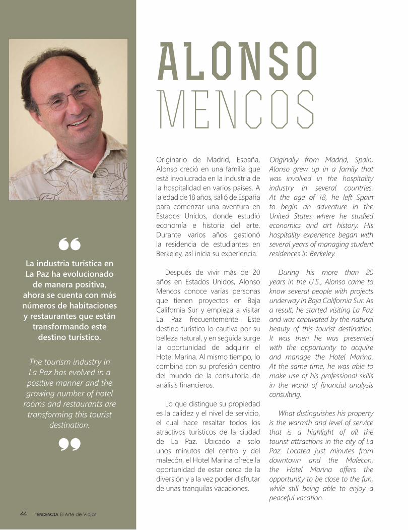
ALONSO MENCOSOriginario de Madrid, España, Alonso creció en una familia que está involucrada en la industria de la hospitalidad en varios países. A la edad de 18 años, salió de España para comenzar una aventura en Estados Unidos, donde estudió economía e historia del arte. Durante varios años gestionó la residencia de estudiantes en Berkeley, así inicia su experiencia.
Después de vivir más de 20 años en Estados Unidos, Alonso Mencos conoce varias personas que tienen proyectos en Baja California Sur y empieza a visitar La Paz frecuentemente. Este destino turístico lo cautiva por su belleza natural, y en seguida surge la oportunidad de adquirir el Hotel Marina. Al mismo tiempo, lo combina con su profesión dentro del mundo de la consultoría de análisis financieros.
Lo que distingue su propiedad es la calidez y el nivel de servicio, el cual hace resaltar todos los atractivos turísticos de la ciudad de La Paz. Ubicado a solo unos minutos del centro y del malecón, el Hotel Marina ofrece la oportunidad de estar cerca de la diversión y a la vez poder disfrutar de unas tranquilas vacaciones.
Originally from Madrid, Spain, Alonso grew up in a family that was involved in the hospitality industry in several countries. At the age of 18, he left Spain to begin an adventure in the United States where he studied economics and art history. His hospitality experience began with several years of managing student residences in Berkeley.
During his more than 20 years in the U.S., Alonso came to know several people with projects underway in Baja California Sur. As a result, he started visiting La Paz and was captivated by the natural beauty of this tourist destination. It was then he was presented with the opportunity to acquire and manage the Hotel Marina. At the same time, he was able to make use of his professional skills in the world of financial analysis consulting.
What distinguishes his property is the warmth and level of service that is a highlight of all the tourist attractions in the city of La Paz. Located just minutes from downtown and the Malecon, the Hotel Marina offers the opportunity to be close to the fun, while still being able to enjoy a peaceful vacation.
La industria turística en La Paz ha evolucionado
de manera positiva, ahora se cuenta con más números de habitaciones y restaurantes que están
transformando este destino turístico.
The tourism industry in La Paz has evolved in a positive manner and the growing number of hotel
rooms and restaurants are transforming this tourist
destination.
Tendencia El Arte de Viajar44
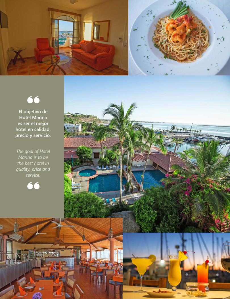
El objetivo de Hotel Marina
es ser el mejor hotel en calidad, precio y servicio.
The goal of Hotel Marina is to be the best hotel in quality, price and
service.
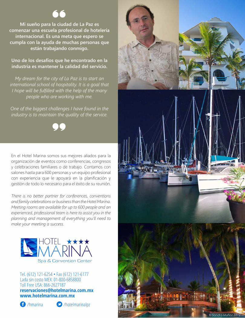
Mi sueño para la ciudad de La Paz es comenzar una escuela profesional de hotelería
internacional. Es una meta que espero se cumpla con la ayuda de muchas personas que
están trabajando conmigo.
Uno de los desafíos que he encontrado en la industria es mantener la calidad del servicio.
My dream for the city of La Paz is to start an international school of hospitality. It is a goal that I hope will be fulfilled with the help of the many
people who are working with me.
One of the biggest challenges I have found in the industry is to maintain the quality of the service.
Tel. (612) 121-6254 • Fax (612) 121-6177Lada sin costo MEX: 01-800-6858800 Toll Free USA: 866-2627187reservaciones@hotelmarina.com.mxwww.hotelmarina.com.mx
/hotelmarinalpz/hmarina
En el Hotel Marina somos sus mejores aliados para la organización de eventos como conferencias, congresos y celebraciones familiares o de trabajo. Contamos con salones hasta para 600 personas y un equipo profesional con experiencia que le apoyará en la planificación y gestión de todo lo necesario para el éxito de su reunión.
There is no better partner for conferences, conventions and family celebrations or business than the Hotel Marina. Meeting rooms are available for up to 600 people and an experienced, professional team is here to assist you in the planning and management of everything you’ll need to make your meeting a success.

Semblanza del Autor:
Vocación de maestro, locutor, político y reconocido escritor que ha dejado plasmado en varios libros, el pasado y presente de esta península, así como sus usos y costumbres. Nace en la ciudad de La Paz donde realiza sus estudios como normalista. Tiempo después, en el Distrito Federal continúa su preparación en el mundo de las letras, con especialidad en Lengua y Literatura.
Armando ostentó varios puestos públicos, entre ellos fue Presidente del Congreso Constituyente del Estado, Oficial Mayor, Diputado y Senador de la República. Ahora a pesar de haberse retirado activamente de la política, sigue vigente compartiendo experiencias de vida e investigaciones a través de sus libros.
Semblanza del Libro:
Extraordinaria selección de temas acerca de las ballenas que sumerge al lector en información de interés sobre los cetáceos que visitan la península de Baja California, es un libro 100% didáctico donde fácilmente se podrá aprender lo relacionado con: El Origen y Evolución, Cetáceos y Clasificación, Biología y Reproducción; éstos solo por mencionar algunos capítulos.
Portrait of the Author:
Armando’s vocations as a teacher, broadcaster, politician and renowned author, as well as the past and present and manners and customs of this peninsula, are reflected in his books. He was born in the city of La Paz where he attended public school. Later, in Mexico City, he continued his studies in literature, specializing in linguistic analysis and related areas.
Armando held several political positions including President of the Constituent Congress of the State, and Officer, Deputy and Senator of the Republic. Despite having retired from active politics, he continues to share his life experiences and discoveries through his books.
Portrait of the Book:
This fascinating selection of topics about whales immerses the reader in interesting information about the cetaceans who visit Baja California. The book is educational in nature and allows readers to easily learn about The Origin and Evolution, Cetaceans and Classifications, and Biology and Reproduction, just to name a few of the chapters.
¿Que deseas saber
de las ballenas de
Baja California?What would you like to know
about the whales of
Baja California?
Armando Trasviña Taylor
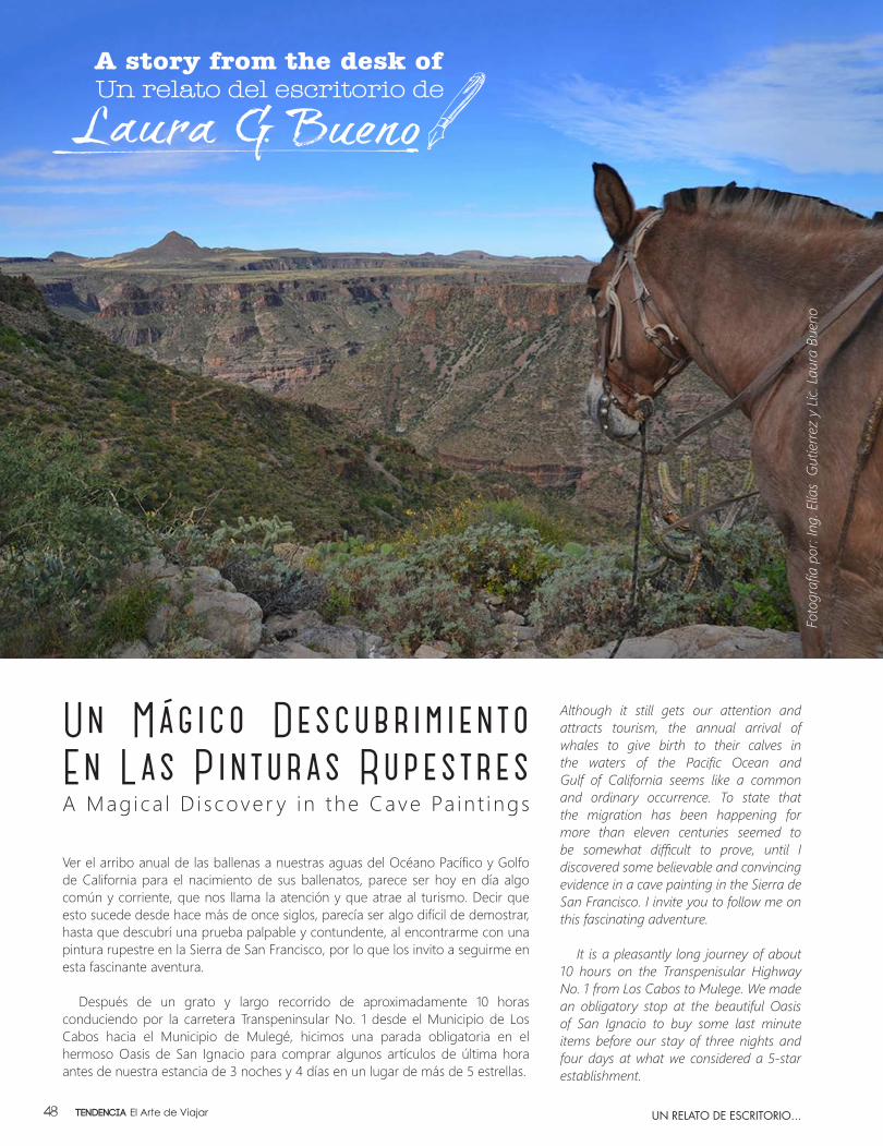
Ver el arribo anual de las ballenas a nuestras aguas del Océano Pacífico y Golfo de California para el nacimiento de sus ballenatos, parece ser hoy en día algo común y corriente, que nos llama la atención y que atrae al turismo. Decir que esto sucede desde hace más de once siglos, parecía ser algo difícil de demostrar, hasta que descubrí una prueba palpable y contundente, al encontrarme con una pintura rupestre en la Sierra de San Francisco, por lo que los invito a seguirme en esta fascinante aventura.
Después de un grato y largo recorrido de aproximadamente 10 horas conduciendo por la carretera Transpeninsular No. 1 desde el Municipio de Los Cabos hacia el Municipio de Mulegé, hicimos una parada obligatoria en el hermoso Oasis de San Ignacio para comprar algunos artículos de última hora antes de nuestra estancia de 3 noches y 4 días en un lugar de más de 5 estrellas.
Although it still gets our attention and attracts tourism, the annual arrival of whales to give birth to their calves in the waters of the Pacific Ocean and Gulf of California seems like a common and ordinary occurrence. To state that the migration has been happening for more than eleven centuries seemed to be somewhat difficult to prove, until I discovered some believable and convincing evidence in a cave painting in the Sierra de San Francisco. I invite you to follow me on this fascinating adventure.
It is a pleasantly long journey of about 10 hours on the Transpenisular Highway No. 1 from Los Cabos to Mulege. We made an obligatory stop at the beautiful Oasis of San Ignacio to buy some last minute items before our stay of three nights and four days at what we considered a 5-star establishment.
Un Mágico DescubrimientoEn Las Pinturas RupestresA Mag ica l D i scover y in the Cave Pa in t ings
Foto
graf
ía p
or: I
ng. E
lías
Gut
ierr
ez y
Lic.
Lau
ra B
ueno
UN RELATO DE ESCRITORIO...Tendencia El Arte de Viajar48
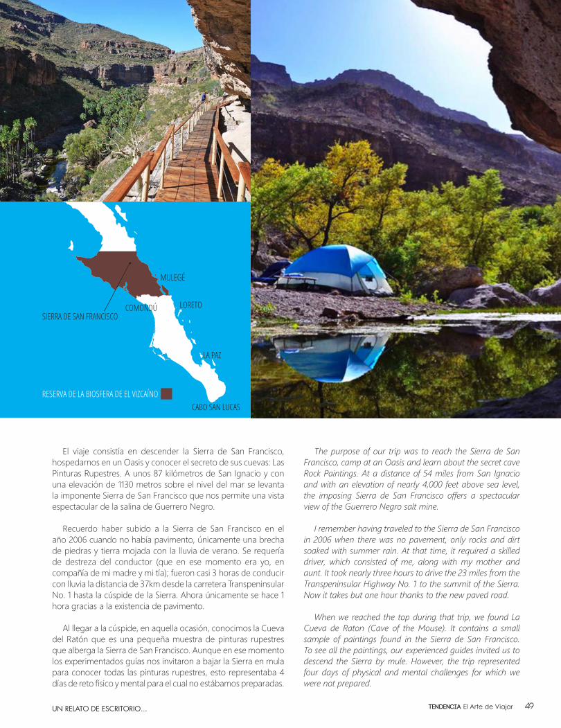
El viaje consistía en descender la Sierra de San Francisco, hospedarnos en un Oasis y conocer el secreto de sus cuevas: Las Pinturas Rupestres. A unos 87 kilómetros de San Ignacio y con una elevación de 1130 metros sobre el nivel del mar se levanta la imponente Sierra de San Francisco que nos permite una vista espectacular de la salina de Guerrero Negro.
Recuerdo haber subido a la Sierra de San Francisco en el año 2006 cuando no había pavimento, únicamente una brecha de piedras y tierra mojada con la lluvia de verano. Se requería de destreza del conductor (que en ese momento era yo, en compañía de mi madre y mi tía); fueron casi 3 horas de conducir con lluvia la distancia de 37km desde la carretera Transpeninsular No. 1 hasta la cúspide de la Sierra. Ahora únicamente se hace 1 hora gracias a la existencia de pavimento.
Al llegar a la cúspide, en aquella ocasión, conocimos la Cueva del Ratón que es una pequeña muestra de pinturas rupestres que alberga la Sierra de San Francisco. Aunque en ese momento los experimentados guías nos invitaron a bajar la Sierra en mula para conocer todas las pinturas rupestres, esto representaba 4 días de reto físico y mental para el cual no estábamos preparadas.
The purpose of our trip was to reach the Sierra de San Francisco, camp at an Oasis and learn about the secret cave Rock Paintings. At a distance of 54 miles from San Ignacio and with an elevation of nearly 4,000 feet above sea level, the imposing Sierra de San Francisco offers a spectacular view of the Guerrero Negro salt mine.
I remember having traveled to the Sierra de San Francisco in 2006 when there was no pavement, only rocks and dirt soaked with summer rain. At that time, it required a skilled driver, which consisted of me, along with my mother and aunt. It took nearly three hours to drive the 23 miles from the Transpeninsular Highway No. 1 to the summit of the Sierra. Now it takes but one hour thanks to the new paved road.
When we reached the top during that trip, we found La Cueva de Raton (Cave of the Mouse). It contains a small sample of paintings found in the Sierra de San Francisco. To see all the paintings, our experienced guides invited us to descend the Sierra by mule. However, the trip represented four days of physical and mental challenges for which we were not prepared.
SIERRA DE SAN FRANCISCO
LA PAZ
LORETO
MULEGÉ
COMONDÚ
CABO SAN LUCASRESERVA DE LA BIOSFERA DE EL VIZCAÍNO
UN RELATO DE ESCRITORIO... 49Tendencia El Arte de Viajar
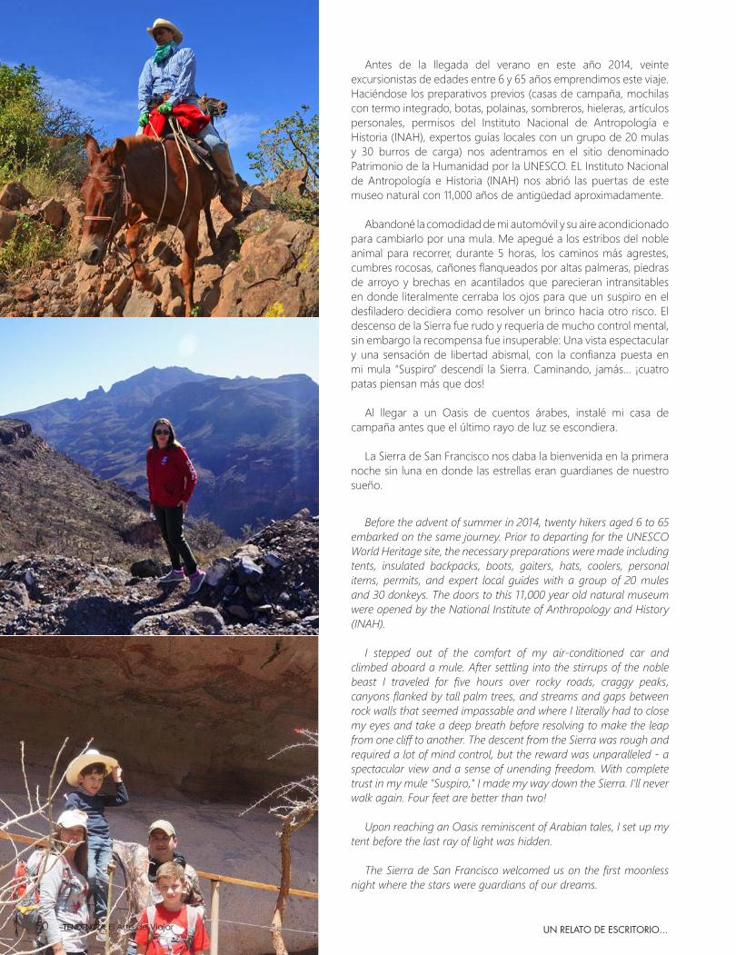
Antes de la llegada del verano en este año 2014, veinte excursionistas de edades entre 6 y 65 años emprendimos este viaje. Haciéndose los preparativos previos (casas de campaña, mochilas con termo integrado, botas, polainas, sombreros, hieleras, artículos personales, permisos del Instituto Nacional de Antropología e Historia (INAH), expertos guías locales con un grupo de 20 mulas y 30 burros de carga) nos adentramos en el sitio denominado Patrimonio de la Humanidad por la UNESCO. EL Instituto Nacional de Antropología e Historia (INAH) nos abrió las puertas de este museo natural con 11,000 años de antigüedad aproximadamente.
Abandoné la comodidad de mi automóvil y su aire acondicionado
para cambiarlo por una mula. Me apegué a los estribos del noble animal para recorrer, durante 5 horas, los caminos más agrestes, cumbres rocosas, cañones flanqueados por altas palmeras, piedras de arroyo y brechas en acantilados que parecieran intransitables en donde literalmente cerraba los ojos para que un suspiro en el desfiladero decidiera como resolver un brinco hacia otro risco. El descenso de la Sierra fue rudo y requería de mucho control mental, sin embargo la recompensa fue insuperable: Una vista espectacular y una sensación de libertad abismal, con la confianza puesta en mi mula “Suspiro” descendí la Sierra. Caminando, jamás… ¡cuatro patas piensan más que dos!
Al llegar a un Oasis de cuentos árabes, instalé mi casa de campaña antes que el último rayo de luz se escondiera.
La Sierra de San Francisco nos daba la bienvenida en la primera noche sin luna en donde las estrellas eran guardianes de nuestro sueño.
Before the advent of summer in 2014, twenty hikers aged 6 to 65 embarked on the same journey. Prior to departing for the UNESCO World Heritage site, the necessary preparations were made including tents, insulated backpacks, boots, gaiters, hats, coolers, personal items, permits, and expert local guides with a group of 20 mules and 30 donkeys. The doors to this 11,000 year old natural museum were opened by the National Institute of Anthropology and History (INAH).
I stepped out of the comfort of my air-conditioned car and climbed aboard a mule. After settling into the stirrups of the noble beast I traveled for five hours over rocky roads, craggy peaks, canyons flanked by tall palm trees, and streams and gaps between rock walls that seemed impassable and where I literally had to close my eyes and take a deep breath before resolving to make the leap from one cliff to another. The descent from the Sierra was rough and required a lot of mind control, but the reward was unparalleled - a spectacular view and a sense of unending freedom. With complete trust in my mule "Suspiro," I made my way down the Sierra. I’ll never walk again. Four feet are better than two!
Upon reaching an Oasis reminiscent of Arabian tales, I set up my tent before the last ray of light was hidden.
The Sierra de San Francisco welcomed us on the first moonless night where the stars were guardians of our dreams.
UN RELATO DE ESCRITORIO...Tendencia El Arte de Viajar50
UN RELATO DE ESCRITORIO...
Durante las 3 mañanas siguientes, después de un buen desayuno, caminábamos varias horas al día para ver el arte rupestre cuyos bastidores eran las paredes mismas de las cuevas.
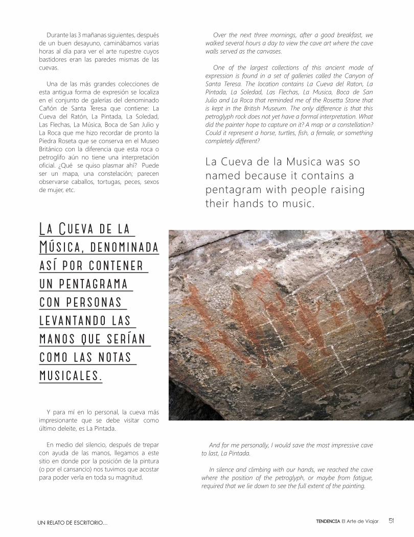
Una de las más grandes colecciones de esta antigua forma de expresión se localiza en el conjunto de galerías del denominado Cañón de Santa Teresa que contiene: La Cueva del Ratón, La Pintada, La Soledad, Las Flechas, La Música, Boca de San Julio y La Roca que me hizo recordar de pronto la Piedra Roseta que se conserva en el Museo Británico con la diferencia que esta roca o petroglifo aún no tiene una interpretación oficial. ¿Qué se quiso plasmar ahí? Puede ser un mapa, una constelación; parecen observarse caballos, tortugas, peces, sexos de mujer, etc.
La Cueva de la Música, denominada así por contener un pentagrama con personas levantando las manos que serían como las notas musicales.
Y para mí en lo personal, la cueva más impresionante que se debe visitar como último deleite, es La Pintada.
En medio del silencio, después de trepar con ayuda de las manos, llegamos a este sitio en donde por la posición de la pintura (o por el cansancio) nos tuvimos que acostar para poder verla en toda su magnitud.
Over the next three mornings, after a good breakfast, we walked several hours a day to view the cave art where the cave walls served as the canvases.
One of the largest collections of this ancient mode of expression is found in a set of galleries called the Canyon of Santa Teresa. The location contains La Cueva del Raton, La Pintada, La Soledad, Las Flechas, La Musica, Boca de San Julio and La Roca that reminded me of the Rosetta Stone that is kept in the British Museum. The only difference is that this petroglyph rock does not yet have a formal interpretation. What did the painter hope to capture on it? A map or a constellation? Could it represent a horse, turtles, fish, a female, or something completely different?
La Cueva de la Musica was so named because it contains a pentagram with people raising their hands to music.
And for me personally, I would save the most impressive cave to last, La Pintada.
In silence and climbing with our hands, we reached the cave where the position of the petroglyph, or maybe from fatigue, required that we lie down to see the full extent of the painting.
51Tendencia El Arte de Viajar
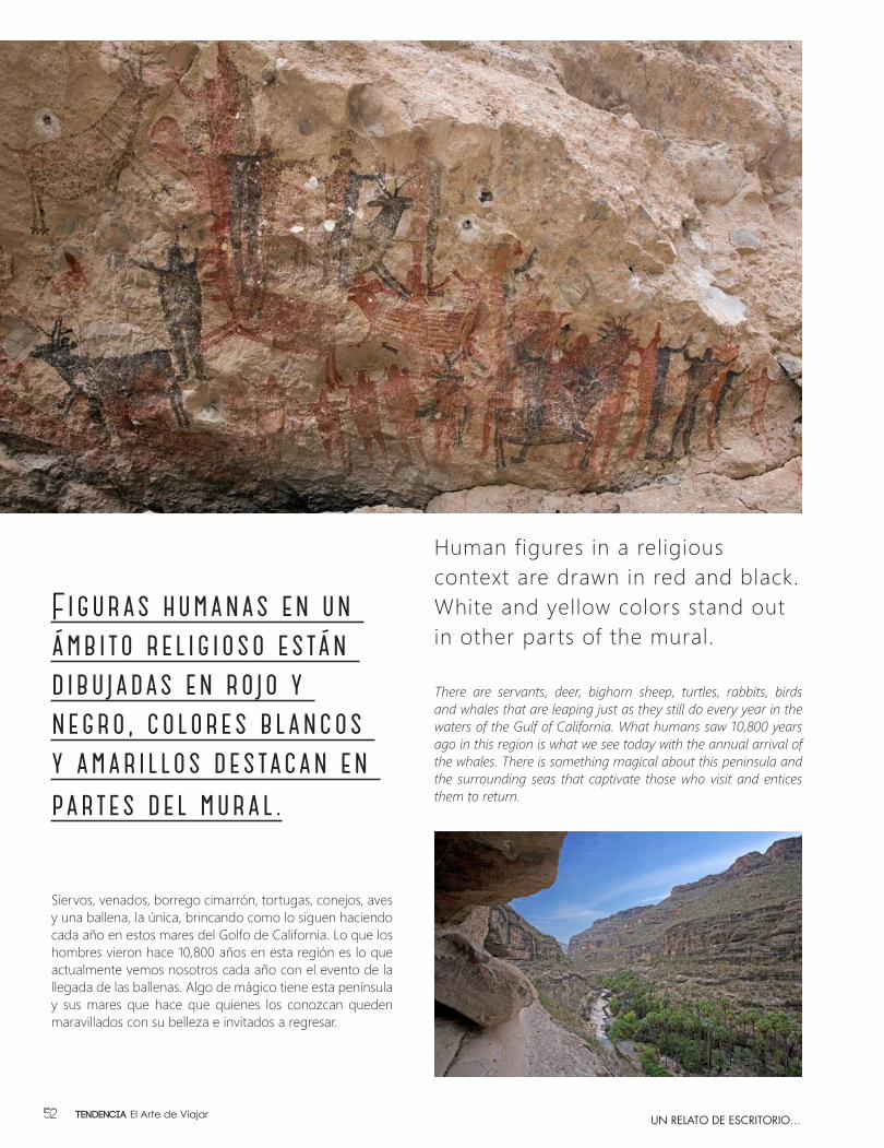
Figuras humanas en un ámbito religioso están dibujadas en rojo y negro, colores blancos y amarillos destacan en partes del mural.
Human figures in a religious context are drawn in red and black. White and yellow colors stand out in other parts of the mural.
There are servants, deer, bighorn sheep, turtles, rabbits, birds and whales that are leaping just as they still do every year in the waters of the Gulf of California. What humans saw 10,800 years ago in this region is what we see today with the annual arrival of the whales. There is something magical about this peninsula and the surrounding seas that captivate those who visit and entices them to return.
UN RELATO DE ESCRITORIO...
Siervos, venados, borrego cimarrón, tortugas, conejos, aves y una ballena, la única, brincando como lo siguen haciendo cada año en estos mares del Golfo de California. Lo que los hombres vieron hace 10,800 años en esta región es lo que actualmente vemos nosotros cada año con el evento de la llegada de las ballenas. Algo de mágico tiene esta península y sus mares que hace que quienes los conozcan queden maravillados con su belleza e invitados a regresar.
Tendencia El Arte de Viajar52

Los pensamientos sobre el tiempo, la vida, el mundo y el hombre parecen tomar forma al bajar al mundo mágico y encantado de la Sierra de San Francisco. Visitar este recinto te sumerge en una dimensión diferente en donde te llenas de energía natural muchas veces necesaria para valorar el mundo que yace al otro lado de la montaña. Quizá la única experiencia que te transporte a un lugar equivalente a la Sierra de San Francisco, en donde te rodea el silencio y tus pensamientos, sea en el fondo del mar. Aún no tengo la fortuna de vivir esta aventura pero con esta clase de amigos tan valiosos como valientes, quizá a la siguiente, les pueda narrar un viaje para conocer al tiburón blanco en su hábitat natural.
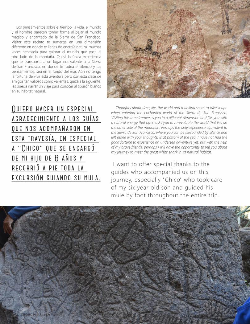
Quiero hacer un especial agradecimiento a los guías que nos acompañaron en esta travesía, en especial a “Chico” que se encargó de mi hijo de 6 años y recorrió a pie toda la excursión guiando su mula.
Thoughts about time, life, the world and mankind seem to take shape when entering the enchanted world of the Sierra de San Francisco. Visiting this area immerses you in a different dimension and fills you with a natural energy that often asks you to re-evaluate the world that lies on the other side of the mountain. Perhaps the only experience equivalent to the Sierra de San Francisco, where you can be surrounded by silence and left alone with your thoughts, is at bottom of the sea. I have not had the good fortune to experience an undersea adventure yet, but with the help of my brave friends, perhaps I will have the opportunity to tell you about my journey to meet the great white shark in its natural habitat.
I want to offer special thanks to the guides who accompanied us on this journey, especially "Chico" who took care of my six year old son and guided his mule by foot throughout the entire trip.
UN RELATO DE ESCRITORIO...Tendencia El Arte de Viajar54
Islas Sudcalifornianas
y
Baja California Sur tiene la mayor cantidad de kilómetros de litoral en todo el país con un gran número de islas e islotes, la mayoría están deshabitadas por lo que visitarlas es un pretexto para estar inmerso en la naturaleza. Recorrer las costas del Estado es un viaje que lo llevará de asombro en asombro con vistas espectaculares.
En la travesía tendrá la opción de desembarcar en las playas que elija explorar o hacer alguna actividad recreativa. Al mismo tiempo, encontrará pequeñas comunidades pesqueras que estarán felices de recibirlo y ser los anfitriones del tiempo que permanezca como visitante.
Baja California Sur has more miles of coastline than the rest of Mexico and is home to many islands and islets. Most of the islands are uninhabited and visiting them is an excuse to be immersed in nature. Traveling the coast of Baja California Sur is an amazing journey complete with spectacular views.
During the trip, you have the option of landing on a choice of beaches perfect for exploring or engaging in a recreational activity. At the same time, you will find small fishing communities who will be happy to welcome you and be your host for the time you stay.
ELIGIO MOISÉS CORONADO
Fotog
rafía
: Osca
r Ortíz
55Tendencia El Arte de Viajar
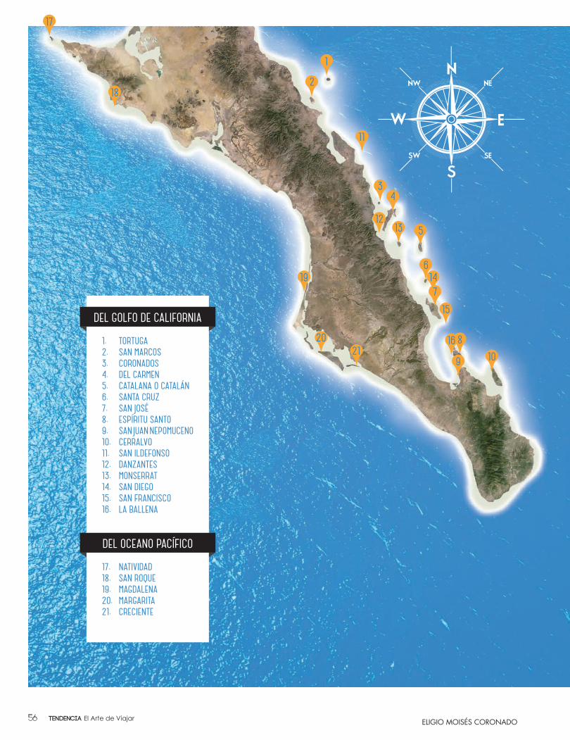
1. TORTUGA2. SAN MARCOS3. CORONADOS4. DEL CARMEN5. CATALANA O CATALÁN6. SANTA CRUZ7. SAN JOSÉ8. ESPÍRITU SANTO9. SAN JUAN NEPOMUCENO10. CERRALVO11. SAN ILDEFONSO12. DANZANTES13. MONSERRAT14. SAN DIEGO15. SAN FRANCISCO16. LA BALLENA
17. NATIVIDAD18. SAN ROQUE19. MAGDALENA20. MARGARITA21. CRECIENTE
DEL GOLFO DE CALIFORNIA
DEL OCEANO PACÍFICO
ELIGIO MOISÉS CORONADOTendencia El Arte de Viajar56

ACTIVIDADES QUE SE PUEDEN REALIZAR
Navegación de esparcimientoRecreational Navigation
La navegación se ha practicado desde la antigüedad. Es una habilidad que permite explorar los océanos. El Mar de Cortés y el Océano Pacífico son un recorrido
sorprendente, donde los navegantes tienen la oportunidad de mostrar su conocimiento geográfico,
aptitudes fotográficas o simplemente vivir una experiencia memorable.
Navigation has been practiced since ancient times. It is a necessary skill for exploring the oceans of the world. The Sea of Cortez and Ocean Pacific are an amazing
journey where navigators have the opportunity to demonstrate their knowledge of geography
and photography or their ability to simply enjoy a memorable experience.
ISLAND ACTIVITIES
Caminatas Hiking
Es una actividad muy divertida caminar al aire libre y explorar las islas. Se puede combinar con un tiempo para
acampar, en las islas que sea permitido.
A popular, informative and particularly fun method for exploring the island coasts is on foot. Walks could be
combined with a camping time, if it is allowed in the island.
Pesca DeportivaSportfishing
La belleza de los alrededores de las islas y la cantidad de especies marinas, enriquecen la práctica de la pesca. Es
una de las actividades más populares en la península. Una serie de torneos se celebran cada año.
The beauty surrounding the islands and the number of big game species along the coast make sport fishing one of
the most popular activities on the peninsula. A number of tournaments are held here every year.
Buceo - SnorkelingDiving - Snorkeling
Es la mejor manera de experimentar la vida submarina del hermoso Mar de Cortés, llamado Acuario del Mundo por Jacques
Cousteau. Dentro de esta actividad se puede observar una enorme variedad de ambientes marinos, así como tiburones
ballenas y mantarrayas.
There’s no better way to experience the underwater marvels of what Jacques Cousteau called “the aquarium of the world.” Divers
and snorkelers can enjoy a variety of marine environments and sea life including whale sharks and manta rays.
ELIGIO MOISÉS CORONADO 57Tendencia El Arte de Viajar
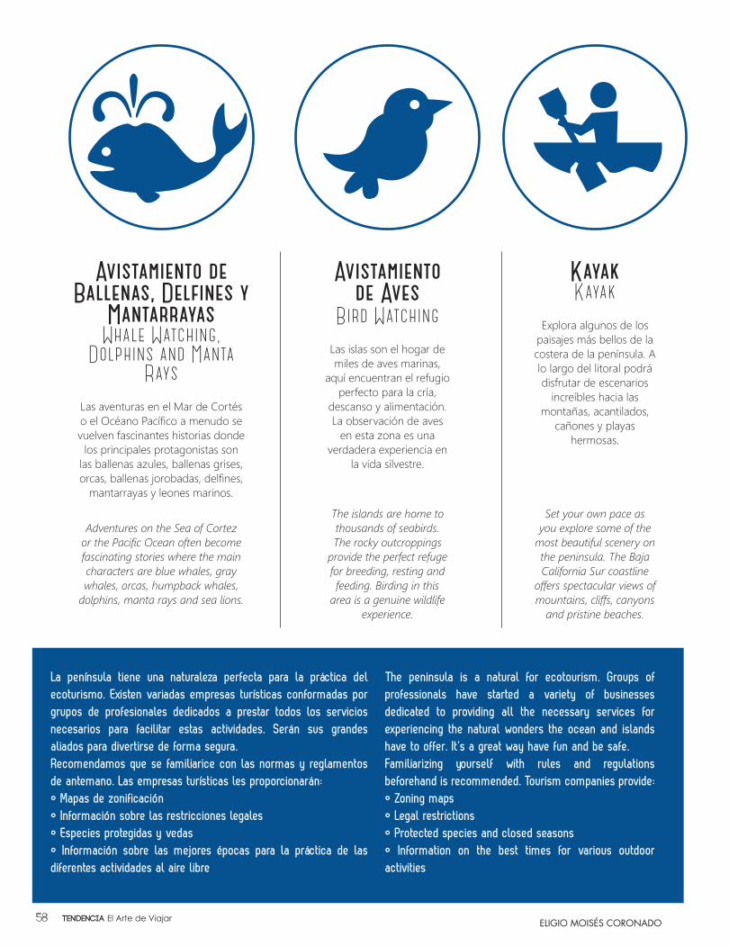
Avistamiento de Ballenas, Delfines y
MantarrayasWhale Watching,
Dolphins and Manta Rays
Las aventuras en el Mar de Cortés o el Océano Pacífico a menudo se vuelven fascinantes historias donde
los principales protagonistas son las ballenas azules, ballenas grises, orcas, ballenas jorobadas, delfines,
mantarrayas y leones marinos.
Adventures on the Sea of Cortez or the Pacific Ocean often become fascinating stories where the main characters are blue whales, gray whales, orcas, humpback whales,
dolphins, manta rays and sea lions.
La península tiene una naturaleza perfecta para la práctica del ecoturismo. Existen variadas empresas turísticas conformadas por grupos de profesionales dedicados a prestar todos los servicios necesarios para facilitar estas actividades. Serán sus grandes aliados para divertirse de forma segura.Recomendamos que se familiarice con las normas y reglamentos de antemano. Las empresas turísticas les proporcionarán: • Mapas de zonificación• Información sobre las restricciones legales• Especies protegidas y vedas• Información sobre las mejores épocas para la práctica de las diferentes actividades al aire libre
Avistamiento de Aves
Bird WatchingLas islas son el hogar de miles de aves marinas,
aquí encuentran el refugio perfecto para la cría,
descanso y alimentación. La observación de aves
en esta zona es una verdadera experiencia en
la vida silvestre.
The islands are home to thousands of seabirds. The rocky outcroppings
provide the perfect refuge for breeding, resting and feeding. Birding in this
area is a genuine wildlife experience.
Set your own pace as you explore some of the
most beautiful scenery on the peninsula. The Baja California Sur coastline
offers spectacular views of mountains, cliffs, canyons
and pristine beaches.
KayakKayak
Explora algunos de los paisajes más bellos de la costera de la península. A lo largo del litoral podrá disfrutar de escenarios
increíbles hacia las montañas, acantilados,
cañones y playas hermosas.
The peninsula is a natural for ecotourism. Groups of professionals have started a variety of businesses dedicated to providing all the necessary services for experiencing the natural wonders the ocean and islands have to offer. It’s a great way have fun and be safe.Familiarizing yourself with rules and regulations beforehand is recommended. Tourism companies provide:• Zoning maps• Legal restrictions • Protected species and closed seasons• Information on the best times for various outdoor activities
ELIGIO MOISÉS CORONADOTendencia El Arte de Viajar58
PRIVATESNORKEL
WHALE
SUNSET
WATCHING
DINNER
LUNCH
SEA LIONS
WHALE
ISLAND
SHARK
ESPIRITU SANTO
SCUBA DIVING
RESERVATION: Ph: 52 (624) 143-2252 US: (619) [email protected] • www.sunr idertours.com sunridertoursviajes
EXCELLENT SERVICE & ENTERTAINMENT BOATSAND THE ALL YOU CAN EAT & DRINK CABO CRUISES
V
IEW
S
GREAT
TOURSFUN

1. TORTUGA. Pequeña isla de origen volcánico, a 40km de la costa; es un volcán en escudo (de gran dimensión y formado a partir de las capas de sucesivas erupciones). Tiene una caldera circular de 1 km de ancho y 100 m de profundidad, al oeste del centro de la isla.
A small volcanic island 25 miles from the coast. Tortuga is a large basaltic shield volcano formed from successive layers of eruptions. The circular caldera is a half-mile wide and more than 300 feet deep and is located to the west of the island center.
2. SAN MARCOS. Descubierta en 1539 por Francisco de Ulloa. Tiene una superficie de 28.75km², está a 5km de la costa. Fue concesionada en 1923 para la extracción de yeso a la Compañía Occidental Mexicana, ésta aporta el 85% de la producción nacional. La comunidad está habitada por 300 personas aproximadamente.
Discovered in 1539 by Francisco de Ulloa, San Marcos has an area of 18 square miles and is located three miles from the coast. The island has been the property of the Compañia Occidental Mexicana since 1923 and contributes 85 percent of the national production of gypsum. The community is inhabited by about 300 people.
3. CORONADOS. Se encuentra a 9km al noreste de Loreto. Esta isla es de forma irregular, con 5km de largo y un poco menos de ancho; en la parte norte sus elevaciones alcanzan los 300m. Descubierta y bautizada por Francisco de Ortega en 1633. Sus piedras de cal fueron usadas por los jesuitas en la construcción de la iglesia y otros edificios en Loreto. Su nombre, tomado del calendario cristiano, se refiere a tres mártires húngaros del catolicismo. Sus costas están cubiertas por montículos rocosos muy escarpados, excepto al sureste, donde se encuentra cubierta por dunas de arena que visitan las tortugas marinas en cierta época del año, buscando dónde depositar sus huevos.
Located nine miles northeast of Loreto, Coronados is an irregularly shaped island about four miles long and a little less in width. The north side elevation reaches nearly 1,000 feet. Coronados was discovered and named by Francisco de Ortega in 1633. The name, taken from the Christian calendar, refers to three Hungarian martyrs of Catholicism. The island shores are very steep and rocky except in the southeast where the sand dunes have been declared a marine sanctuary. Sea turtles lay eggs here during certain times of year.
4. DEL CARMEN. Esta ínsula se podría considerar como una de las más extensas del Estado, de Punta Baja a Punta Lobos, que son sus extremos, mide casi 33km. Parece estar formada totalmente de sal y se considera la salina más grande del mundo. Fue descubierta en la época en que los misioneros españoles recorrían nuestro territorio para cristianizarlo. Fue bautizada en 1633 por Francisco de Ortega, quien encontró la isla habitada. Además se convirtió en uno de los lugares preferidos de los pescadores de perlas en los siglos XVII y XVIII. Fue utilizada por los misioneros para pastoreo. La primera concesión para explotar el saladar fue solicitada por el padre Salvatierra a principios del siglo XVIII; después las salinas quedaron abandonadas hasta la segunda mitad del siglo XIX. Actualmente su producción no se ha visto disminuida. Tiene un pequeño pueblo donde se embarca la sal a diferentes partes.
This island is considered one of the largest in the State. The distance from Punta Baja to Point Lobos is almost 21 miles. Del Carmen appears to be made entirely of salt and is considered the world’s largest salt mine. It was discovered during the period of Spanish evangelization in 1633 and named by Francisco de Ortega who found the island inhabited. Del Carmen was also one of the preferred locations for pearl divers in the seventeenth and eighteenth centuries. Missionaries used the island for grazing. The first effort to exploit the salt resources was made by Father Salvatierra in the early eighteenth century. When the missionaries left, the salt mine remained abandoned until the second half of the nineteenth century. The current exploration and production of salt remains active. The small town ships the salt to different parts of the world.
ELIGIO MOISÉS CORONADO
Fotos
: © ad
og.m
x / by
Alep
h Alig
hieriEl área de Protección de Flora y Fauna Islas del
Golfo de California fue decretada el 2 de agosto de 1978 por el gobierno federal mexicano.
The Mexican Federal Government declared the islands of the Gulf of California protected areas on August 2, 1978.
Tendencia El Arte de Viajar60
5. CATALANA O CATALÁN. Fue bautizada por Francisco de Ortega, originario de Cataluña. En la mayor parte de los primeros mapas aparece con dichos nombres. En cartas navales de Estados Unidos quedaron cambiados por Santa Catalina. No hay noticias de que haya estado habitada; fue raramente visitada por pescadores de perlas.
Named by Francisco de Ortega who was originally from Catalonia, both names appear in most of the early maps. In US naval charts, the island appears under the single name of Santa Catalana. There is no information that the island was ever inhabited. Pearl divers made rare visits to Catalana.
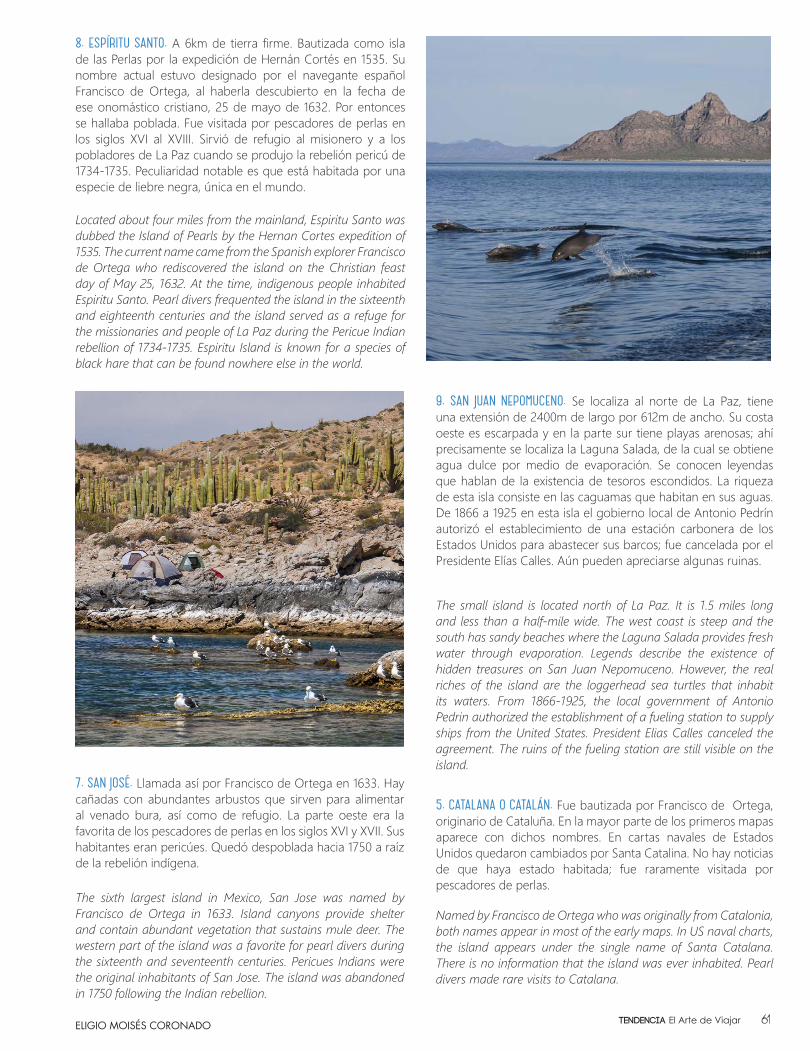
8. ESPÍRITU SANTO. A 6km de tierra firme. Bautizada como isla de las Perlas por la expedición de Hernán Cortés en 1535. Su nombre actual estuvo designado por el navegante español Francisco de Ortega, al haberla descubierto en la fecha de ese onomástico cristiano, 25 de mayo de 1632. Por entonces se hallaba poblada. Fue visitada por pescadores de perlas en los siglos XVI al XVIII. Sirvió de refugio al misionero y a los pobladores de La Paz cuando se produjo la rebelión pericú de 1734-1735. Peculiaridad notable es que está habitada por una especie de liebre negra, única en el mundo.
Located about four miles from the mainland, Espiritu Santo was dubbed the Island of Pearls by the Hernan Cortes expedition of 1535. The current name came from the Spanish explorer Francisco de Ortega who rediscovered the island on the Christian feast day of May 25, 1632. At the time, indigenous people inhabited Espiritu Santo. Pearl divers frequented the island in the sixteenth and eighteenth centuries and the island served as a refuge for the missionaries and people of La Paz during the Pericue Indian rebellion of 1734-1735. Espiritu Island is known for a species of black hare that can be found nowhere else in the world.
9. SAN JUAN NEPOMUCENO. Se localiza al norte de La Paz, tiene una extensión de 2400m de largo por 612m de ancho. Su costa oeste es escarpada y en la parte sur tiene playas arenosas; ahí precisamente se localiza la Laguna Salada, de la cual se obtiene agua dulce por medio de evaporación. Se conocen leyendas que hablan de la existencia de tesoros escondidos. La riqueza de esta isla consiste en las caguamas que habitan en sus aguas. De 1866 a 1925 en esta isla el gobierno local de Antonio Pedrín autorizó el establecimiento de una estación carbonera de los Estados Unidos para abastecer sus barcos; fue cancelada por el Presidente Elías Calles. Aún pueden apreciarse algunas ruinas.
The small island is located north of La Paz. It is 1.5 miles long and less than a half-mile wide. The west coast is steep and the south has sandy beaches where the Laguna Salada provides fresh water through evaporation. Legends describe the existence of hidden treasures on San Juan Nepomuceno. However, the real riches of the island are the loggerhead sea turtles that inhabit its waters. From 1866-1925, the local government of Antonio Pedrin authorized the establishment of a fueling station to supply ships from the United States. President Elias Calles canceled the agreement. The ruins of the fueling station are still visible on the island.
7. SAN JOSÉ. Llamada así por Francisco de Ortega en 1633. Hay cañadas con abundantes arbustos que sirven para alimentar al venado bura, así como de refugio. La parte oeste era la favorita de los pescadores de perlas en los siglos XVI y XVII. Sus habitantes eran pericúes. Quedó despoblada hacia 1750 a raíz de la rebelión indígena.
The sixth largest island in Mexico, San Jose was named by Francisco de Ortega in 1633. Island canyons provide shelter and contain abundant vegetation that sustains mule deer. The western part of the island was a favorite for pearl divers during the sixteenth and seventeenth centuries. Pericues Indians were the original inhabitants of San Jose. The island was abandoned in 1750 following the Indian rebellion.
ELIGIO MOISÉS CORONADO 61Tendencia El Arte de Viajar
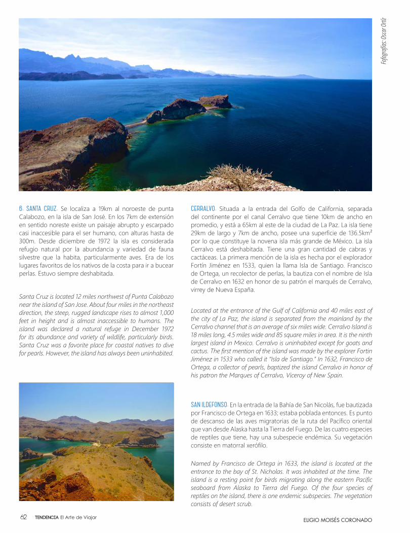
SAN ILDEFONSO. En la entrada de la Bahía de San Nicolás, fue bautizada por Francisco de Ortega en 1633; estaba poblada entonces. Es punto de descanso de las aves migratorias de la ruta del Pacífico oriental que van desde Alaska hasta la Tierra del Fuego. De las cuatro especies de reptiles que tiene, hay una subespecie endémica. Su vegetación consiste en matorral xerófilo.
Named by Francisco de Ortega in 1633, the island is located at the entrance to the bay of St. Nicholas. It was inhabited at the time. The island is a resting point for birds migrating along the eastern Pacific seaboard from Alaska to Tierra del Fuego. Of the four species of reptiles on the island, there is one endemic subspecies. The vegetation consists of desert scrub.
CERRALVO. Situada a la entrada del Golfo de California, separada del continente por el canal Cerralvo que tiene 10km de ancho en promedio, y está a 65km al este de la ciudad de La Paz. La isla tiene 29km de largo y 7km de ancho, posee una superficie de 136.5km² por lo que constituye la novena isla más grande de México. La isla Cerralvo está deshabitada. Tiene una gran cantidad de cabras y cactáceas. La primera mención de la isla es hecha por el explorador Fortín Jiménez en 1533, quien la llama Isla de Santiago. Francisco de Ortega, un recolector de perlas, la bautiza con el nombre de Isla de Cerralvo en 1632 en honor de su patrón el marqués de Cerralvo, virrey de Nueva España.
Located at the entrance of the Gulf of California and 40 miles east of the city of La Paz, the island is separated from the mainland by the Cerralvo channel that is an average of six miles wide. Cerralvo Island is 18 miles long, 4.5 miles wide and 85 square miles in area. It is the ninth largest island in Mexico. Cerralvo is uninhabited except for goats and cactus. The first mention of the island was made by the explorer Fortin Jiménez in 1533 who called it “Isla de Santiago.” In 1632, Francisco de Ortega, a collector of pearls, baptized the island Cerralvo in honor of his patron the Marques of Cerralvo, Viceroy of New Spain.
6. SANTA CRUZ. Se localiza a 19km al noroeste de punta Calabozo, en la isla de San José. En los 7km de extensión en sentido noreste existe un paisaje abrupto y escarpado casi inaccesible para el ser humano, con alturas hasta de 300m. Desde diciembre de 1972 la isla es considerada refugio natural por la abundancia y variedad de fauna silvestre que la habita, particularmente aves. Era de los lugares favoritos de los nativos de la costa para ir a bucear perlas. Estuvo siempre deshabitada.
Santa Cruz is located 12 miles northwest of Punta Calabozo near the island of San Jose. About four miles in the northeast direction, the steep, rugged landscape rises to almost 1,000 feet in height and is almost inaccessible to humans. The island was declared a natural refuge in December 1972 for its abundance and variety of wildlife, particularly birds. Santa Cruz was a favorite place for coastal natives to dive for pearls. However, the island has always been uninhabited.
ELIGIO MOISÉS CORONADO
Fofog
rafía
s: Osca
r Ortíz
Tendencia El Arte de Viajar62
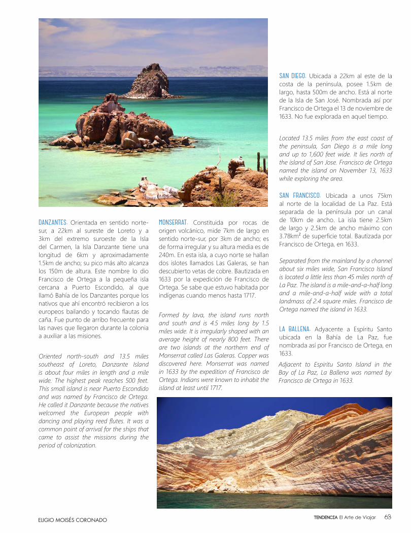
LA BALLENA. Adyacente a Espíritu Santo ubicada en la Bahía de La Paz, fue nombrada así por Francisco de Ortega, en 1633.Adjacent to Espiritu Santo Island in the Bay of La Paz, La Ballena was named by Francisco de Ortega in 1633.
DANZANTES. Orientada en sentido norte-sur, a 22km al sureste de Loreto y a 3km del extremo suroeste de la Isla del Carmen, la Isla Danzante tiene una longitud de 6km y aproximadamente 1.5km de ancho; su pico más alto alcanza los 150m de altura. Este nombre lo dio Francisco de Ortega a la pequeña isla cercana a Puerto Escondido, al que llamó Bahía de los Danzantes porque los nativos que ahí encontró recibieron a los europeos bailando y tocando flautas de caña. Fue punto de arribo frecuente para las naves que llegaron durante la colonia a auxiliar a las misiones.
Oriented north-south and 13.5 miles southeast of Loreto, Danzante Island is about four miles in length and a mile wide. The highest peak reaches 500 feet. This small island is near Puerto Escondido and was named by Francisco de Ortega. He called it Danzante because the natives welcomed the European people with dancing and playing reed flutes. It was a common point of arrival for the ships that came to assist the missions during the period of colonization.
MONSERRAT. Constituida por rocas de origen volcánico, mide 7km de largo en sentido norte-sur, por 3km de ancho; es de forma irregular y su altura media es de 240m. En esta isla, a cuyo norte se hallan dos islotes llamados Las Galeras, se han descubierto vetas de cobre. Bautizada en 1633 por la expedición de Francisco de Ortega. Se sabe que estuvo habitada por indígenas cuando menos hasta 1717.
Formed by lava, the island runs north and south and is 4.5 miles long by 1.5 miles wide. It is irregularly shaped with an average height of nearly 800 feet. There are two islands at the northern end of Monserrat called Las Galeras. Copper was discovered here. Monserrat was named in 1633 by the expedition of Francisco de Ortega. Indians were known to inhabit the island at least until 1717.
SAN DIEGO. Ubicada a 22km al este de la costa de la península, posee 1.5km de largo, hasta 500m de ancho. Está al norte de la Isla de San José. Nombrada así por Francisco de Ortega el 13 de noviembre de 1633. No fue explorada en aquel tiempo.
Located 13.5 miles from the east coast of the peninsula, San Diego is a mile long and up to 1,600 feet wide. It lies north of the island of San Jose. Francisco de Ortega named the island on November 13, 1633 while exploring the area.
SAN FRANCISCO. Ubicada a unos 75km al norte de la localidad de La Paz. Está separada de la península por un canal de 10km de ancho. La isla tiene 2.5km de largo y 2.5km de ancho máximo con 3.78km² de superficie total. Bautizada por Francisco de Ortega, en 1633.
Separated from the mainland by a channel about six miles wide, San Francisco Island is located a little less than 45 miles north of La Paz. The island is a mile-and-a-half long and a mile-and-a-half wide with a total landmass of 2.4 square miles. Francisco de Ortega named the island in 1633.
ELIGIO MOISÉS CORONADO 63Tendencia El Arte de Viajar
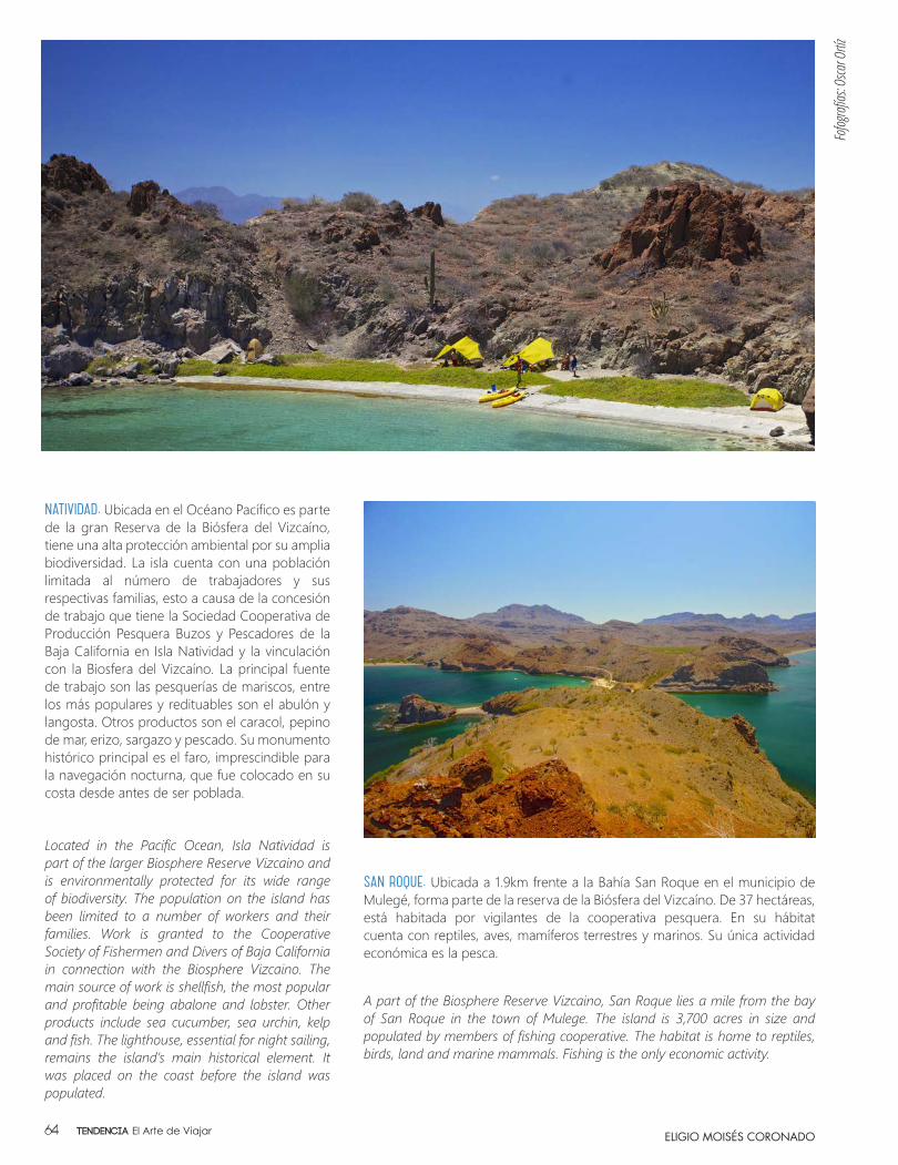
NATIVIDAD. Ubicada en el Océano Pacífico es parte de la gran Reserva de la Biósfera del Vizcaíno, tiene una alta protección ambiental por su amplia biodiversidad. La isla cuenta con una población limitada al número de trabajadores y sus respectivas familias, esto a causa de la concesión de trabajo que tiene la Sociedad Cooperativa de Producción Pesquera Buzos y Pescadores de la Baja California en Isla Natividad y la vinculación con la Biosfera del Vizcaíno. La principal fuente de trabajo son las pesquerías de mariscos, entre los más populares y redituables son el abulón y langosta. Otros productos son el caracol, pepino de mar, erizo, sargazo y pescado. Su monumento histórico principal es el faro, imprescindible para la navegación nocturna, que fue colocado en su costa desde antes de ser poblada.
Located in the Pacific Ocean, Isla Natividad is part of the larger Biosphere Reserve Vizcaino and is environmentally protected for its wide range of biodiversity. The population on the island has been limited to a number of workers and their families. Work is granted to the Cooperative Society of Fishermen and Divers of Baja California in connection with the Biosphere Vizcaino. The main source of work is shellfish, the most popular and profitable being abalone and lobster. Other products include sea cucumber, sea urchin, kelp and fish. The lighthouse, essential for night sailing, remains the island’s main historical element. It was placed on the coast before the island was populated.
SAN ROQUE. Ubicada a 1.9km frente a la Bahía San Roque en el municipio de Mulegé, forma parte de la reserva de la Biósfera del Vizcaíno. De 37 hectáreas, está habitada por vigilantes de la cooperativa pesquera. En su hábitat cuenta con reptiles, aves, mamíferos terrestres y marinos. Su única actividad económica es la pesca.
A part of the Biosphere Reserve Vizcaino, San Roque lies a mile from the bay of San Roque in the town of Mulege. The island is 3,700 acres in size and populated by members of fishing cooperative. The habitat is home to reptiles, birds, land and marine mammals. Fishing is the only economic activity.
ELIGIO MOISÉS CORONADO
Fofog
rafía
s: Osca
r Ortíz
Tendencia El Arte de Viajar64
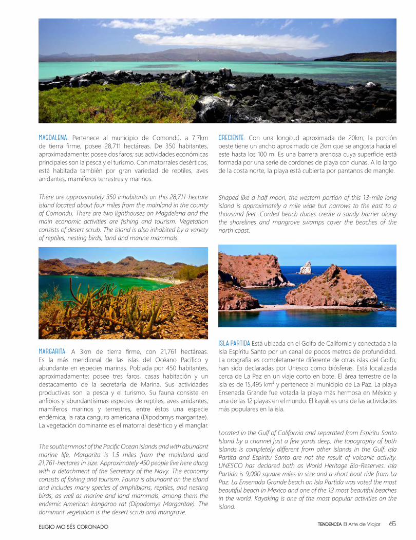
CRECIENTE. Con una longitud aproximada de 20km; la porción oeste tiene un ancho aproximado de 2km que se angosta hacia el este hasta los 100 m. Es una barrera arenosa cuya superficie está formada por una serie de cordones de playa con dunas. A lo largo de la costa norte, la playa está cubierta por pantanos de mangle.
MAGDALENA. Pertenece al municipio de Comondú, a 7.7km de tierra firme, posee 28,711 hectáreas. De 350 habitantes, aproximadamente; posee dos faros; sus actividades económicas principales son la pesca y el turismo. Con matorrales desérticos, está habitada también por gran variedad de reptiles, aves anidantes, mamíferos terrestres y marinos.
MARGARITA. A 3km de tierra firme, con 21,761 hectáreas. Es la más meridional de las islas del Océano Pacífico y abundante en especies marinas. Poblada por 450 habitantes, aproximadamente; posee tres faros, casas habitación y un destacamento de la secretaría de Marina. Sus actividades productivas son la pesca y el turismo. Su fauna consiste en anfibios y abundantísimas especies de reptiles, aves anidantes, mamíferos marinos y terrestres, entre éstos una especie endémica, la rata canguro americana (Dipodomys margaritae). La vegetación dominante es el matorral desértico y el manglar.
Shaped like a half moon, the western portion of this 13-mile long island is approximately a mile wide but narrows to the east to a thousand feet. Corded beach dunes create a sandy barrier along the shorelines and mangrove swamps cover the beaches of the north coast.
There are approximately 350 inhabitants on this 28,711-hectare island located about four miles from the mainland in the county of Comondu. There are two lighthouses on Magdelena and the main economic activities are fishing and tourism. Vegetation consists of desert scrub. The island is also inhabited by a variety of reptiles, nesting birds, land and marine mammals.
The southernmost of the Pacific Ocean islands and with abundant marine life, Margarita is 1.5 miles from the mainland and 21,761-hectares in size. Approximately 450 people live here along with a detachment of the Secretary of the Navy. The economy consists of fishing and tourism. Fauna is abundant on the island and includes many species of amphibians, reptiles, and nesting birds, as well as marine and land mammals, among them the endemic American kangaroo rat (Dipodomys Margaritae). The dominant vegetation is the desert scrub and mangrove.
ELIGIO MOISÉS CORONADO
ISLA PARTIDA Está ubicada en el Golfo de California y conectada a la Isla Espíritu Santo por un canal de pocos metros de profundidad. La orografía es completamente diferente de otras islas del Golfo; han sido declaradas por Unesco como biósferas. Está localizada cerca de La Paz en un viaje corto en bote. El área terrestre de la isla es de 15,495 km² y pertenece al municipio de La Paz. La playa Ensenada Grande fue votada la playa más hermosa en México y una de las 12 playas en el mundo. El kayak es una de las actividades más populares en la isla.
Located in the Gulf of California and separated from Espiritu Santo Island by a channel just a few yards deep, the topography of both islands is completely different from other islands in the Gulf. Isla Partita and Espiritu Santo are not the result of volcanic activity. UNESCO has declared both as World Heritage Bio-Reserves. Isla Partida is 9,000 square miles in size and a short boat ride from La Paz. La Ensenada Grande beach on Isla Partida was voted the most beautiful beach in Mexico and one of the 12 most beautiful beaches in the world. Kayaking is one of the most popular activities on the island.
65Tendencia El Arte de Viajar
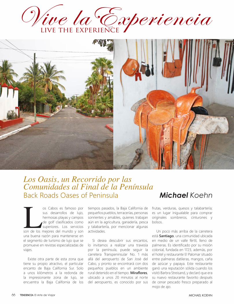
Los Cabos es famoso por sus desarrollos de lujo, hermosas playas y campos de golf clasificados como superiores. Los servicios
son de los mejores del mundo y son una buena razón para mantenerse en el segmento de turismo de lujo que se promueve en revistas especializadas de viajes.
Existe otra parte de esta zona que tiene su propio atractivo, el particular encanto de Baja California Sur. Solo a unos kilómetros a la redonda de la impresionante zona de lujo, se encuentra la Baja California de los
tiempos pasados, la Baja California de pequeños pueblos, terracerías, personas sonrientes y amables, quienes trabajan aún en la agricultura, ganadería, pesca y talabartería, por mencionar algunas actividades.
Si desea descubrir sus encantos, lo invitamos a realizar una travesía por la península, puede seguir la carretera Transpeninsular No. 1 más allá del aeropuerto de San José del Cabo, y pronto se encontrará con dos pequeños pueblos en un ambiente rural detenido en el tiempo. Miraflores, ubicado a unos 20 minutos al norte del aeropuerto, es conocido por sus
Los Oasis, un Recorrido por las Comunidades al Final de la PenínsulaBack Roads Oases of Peninsula Michael Koehn
MICHAEL KOEHN
frutas, verduras, quesos y talabartería; es un lugar inigualable para comprar originales sombreros, cinturones y bolsos.
Un poco más arriba de la carretera está Santiago, una comunidad ubicada en medio de un valle fértil, lleno de palmeras. Es identificado por su misión colonial, fundada en 1723, además, por el hotel y restaurante El Palomar situado entre palmeras datileras, mangos, caña de azúcar y papaya. Este restaurante ganó una reputación sólida cuando los visitó Barbra Streisand, y declaró que era su nuevo restaurante favorito después de cenar pescado fresco preparado al mojo de ajo.
Tendencia El Arte de Viajar66

Los Cabos is justifiably famous for its line-up of luxury resorts, gorgeous beaches and top rated golf courses. These amenities are some of the finest
in the world, and a good reason the area is featured in the high profile glossy ads that are featured in luxury travel and lifestyle magazines.
But there’s another part of this area that has its own appeal - the authentic charm of authentic Baja California Sur. Just around the corner from these impressive coastal features and luxury hotels lies the Baja California of times past, the Baja California of small villages, dusty side streets and smiling, friendly faces of the people who work hard to make a living for their families.
If you’d like to discover some of the charms of the backcountry in southern Baja you can follow Highway 1 towards and past the airport in San Jose del Cabo and you’ll quickly find yourself passing through two small, sleepy villages with an “old Baja” ambiance. Miraflores is located about 20 minutes north of the airport and is known for its fruits, vegetables and cheeses and a fine leather factory located on an access road between the highway and the town center. It’s a great place to shop for bargains on leather hats, belts and bags.
A little further up the road is Santiago, a community located in the middle of a fertile, palm-filled valley. Santiago is known for its colonial mission, founded in 1723, and the El Palomar Hotel and restaurant located on a shady lane in the middle of date palms, mangoes, sugarcane and papayas. El Palomar’s restaurant gained a reputation for solid cooking, and Barbra Streisand visited once and declared El Palomar a favorite new restaurant after dining on fresh pescado prepared mojo de ajo (garlic butter) style. Don’t miss the photo of Bing Crosby with the original owners on the wall.
MICHAEL KOEHN
SANTIAGO
MIRAFLORES
SIERRA DE LA LAGUNA
TODOS SANTOS
CABO SAN LUCAS
EL TRIUNFO
LA PAZ
SAN JOSÉ DEL CABO
SAN ANTONIO
SAN BARTOLO
CABO DEL ESTE
Santiago, B.C.S.
67Tendencia El Arte de Viajar
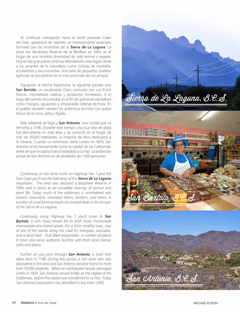
Al continuar manejando hacia el norte pasando Cabo del Este, aparecerá de repente un impresionante escenario formado por las montañas de la Sierra de La Laguna. La zona fue declarada Reserva de la Biósfera en 1994, es el hogar de una increíble diversidad de vida animal y vegetal. Hoy en día gran parte continúa deshabitada, esta región atrae a los amantes de la naturaleza como ciclistas de montaña, escaladores y excursionistas. Una serie de pequeños pueblos agrícolas se encuentran en lo más profundo de sus arroyos.
Siguiendo la misma trayectoria, la siguiente parada será San Bartolo, un exuberante Oasis conocido por sus frutas frescas, mermeladas caseras y productos horneados. A lo largo del camino encontrará un sinfín de golosinas saludables como mangos, aguacates y empanadas rellenas de fruta. En el pueblo también venden los auténticos burritos con queso fresco de la zona, salsa y frijoles.
Más adelante se llega a San Antonio, una ciudad que se remonta a 1748. Durante este tiempo una rica veta de plata fue descubierta en esta área y se convirtió en el hogar de más de 10.000 habitantes, la mayoría de ellos dedicados a la minería. Cuando un terremoto dañó Loreto en 1829, San Antonio sirvió brevemente como la capital de las Californias, antes de que la capital fuera trasladada a La Paz. La población actual de San Antonio es de alrededor de 1.000 personas.
Continuing on the drive north on Highway No. 1 past the East Cape you’ll see the backdrop of the Sierra de La Laguna mountains. The area was declared a Biosphere Reserve in 1994, and is home to an incredible diversity of animal and plant life. Today much of the wilderness is uninhabited and attracts naturalists, mountain bikers, climbers, and hikers. A number of small farming towns are located deep in the arroyos of the Sierra de La Laguna.
Continuing along Highway No. 1 you’ll come to San Bartolo, a lush Oasis known for its fresh fruits, homemade marmalades and baked goods. For a fresh, healthy treat, stop at one of the stands along the road for mangoes, avocados, and a local treat - fruit filled empanadas. A number of places in town also serve authentic burritos with fresh local cheese, salsa and beans.
Further on you pass through San Antonio, a town that dates back to 1748. During this period, a rich silver vein was discovered in the area and San Antonio became home to more than 10,000 residents. When an earthquake heavily damaged Loreto in 1829, San Antonio served briefly as the capital of the Californias, before the capital was transferred to La Paz. Today San Antonio’s population has dwindled to less than 1,000.
MICHAEL KOEHN
Sierra de La Laguna, B.C.S.
San Bartolo, B.C.S.
San Antonio, B.C.S.
Tendencia El Arte de Viajar68

7577 Airway Road, Suite 103, San Diego, CA 92154 U.S. Tel (619) 777-8909, [email protected]
BRINGING GOODS INTO MEXICO?
WAREHOUSE • TRANSPORTATION • IN-HOUSE MEXICAN CUSTOMS BROKER
PROFESSIONAL SERVICE AT AFFORDABLE PRICES...ThIS IS whAT wE’RE ALL ABOuT!
Our mission is to treat our valued customers as we
would like to be treated ourselves. Over 30 years experience!
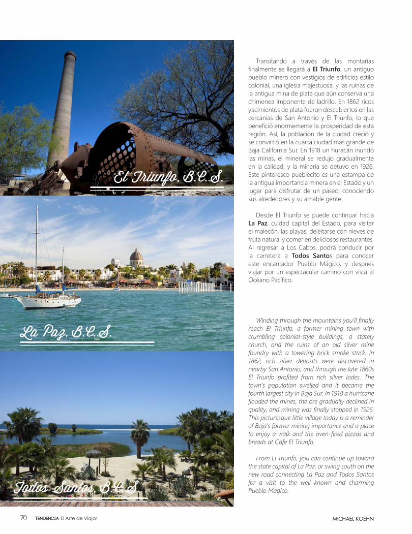
Winding through the mountains you’ll finally reach El Triunfo, a former mining town with crumbling colonial-style buildings, a stately church, and the ruins of an old silver mine foundry with a towering brick smoke stack. In 1862, rich silver deposits were discovered in nearby San Antonio, and through the late 1860s El Triunfo profited from rich silver lodes. The town’s population swelled and it became the fourth largest city in Baja Sur. In 1918 a hurricane flooded the mines, the ore gradually declined in quality, and mining was finally stopped in 1926. This picturesque little village today is a reminder of Baja’s former mining importance and a place to enjoy a walk and the oven-fired pizzas and breads at Cafe El Triunfo.
From El Triunfo, you can continue up toward the state capital of La Paz, or swing south on the new road connecting La Paz and Todos Santos for a visit to the well known and charming Pueblo Magico.
Transitando a través de las montañas finalmente se llegará a El Triunfo, un antiguo pueblo minero con vestigios de edificios estilo colonial, una iglesia majestuosa, y las ruinas de la antigua mina de plata que aún conserva una chimenea imponente de ladrillo. En 1862 ricos yacimientos de plata fueron descubiertos en las cercanías de San Antonio y El Triunfo, lo que benefició enormemente la prosperidad de esta región. Así, la población de la ciudad creció y se convirtió en la cuarta ciudad más grande de Baja California Sur. En 1918 un huracán inundó las minas, el mineral se redujo gradualmente en la calidad, y la minería se detuvo en 1926. Este pintoresco pueblecito es una estampa de la antigua importancia minera en el Estado y un lugar para disfrutar de un paseo, conociendo sus alrededores y su amable gente.
Desde El Triunfo se puede continuar hacia La Paz, cuidad capital del Estado, para visitar el malecón, las playas, deleitarse con nieves de fruta natural y comer en deliciosos restaurantes. Al regresar a Los Cabos, podrá conducir por la carretera a Todos Santos para conocer este encantador Pueblo Mágico, y después viajar por un espectacular camino con vista al Océano Pacífico.
MICHAEL KOEHN
El Triunfo, B.C.S.
La Paz, B.C.S.
Todos Santos, B.C.S.
Tendencia El Arte de Viajar70

ay una leyenda de hace varios siglos, cuando llegaron los españoles a Baja California Sur. La historia tiene un contexto romántico y a la vez
trágico, por como terminaron las cosas. Se trata de un triángulo amoroso.
Antes de la llegada de los españoles, vivía un grupo de indígenas que paseaba libre, recolectaba frutos y vivía de la pesca. El jefe tenía una hija que estaba comprometida para casarse con un joven de la tribu. La leyenda cuenta que ella en una de sus caminatas vio llegar un barco a la playa (actualmente se llama playa Coromuel). Esto era algo totalmente nuevo. Fue la primera persona que lo descubrió, a escondidas iba a verlo y a observar a las personas que allí estaban.
Parecía que el barco se estaba escondiendo de enemigos. Quizá por eso nadie se había aventurado a salir. Cuando uno de ellos se arriesgó a desembarcar, se topó con ella y se enamoraron.
Un día, su prometido fue a buscarla y la sorpresa fue encontrarlos como una pareja de enamorados. Entonces el navegante y el joven se pelearon, en el pleito cayeron por un cerro alto y perdieron la vida. Ella no sabía qué hacer. Estaba tan desesperada que saltó por el acantilado y se suicidó.
Cuando los tres cayeron al mar, la leyenda dice que las olas formaron en las rocas tres calaveras; la más grande la simboliza a ella, y las otras dos a su enamorado y su prometido.
here is a legend from several centuries ago when the Spanish first arrived in Baja California Sur. The story has a romantic beauty
and, at the same time, a tragic ending. It is a love triangle.
Before the arrival of the Spaniards, a group of Indians roamed freely, collecting fruits and living off the bounty of the sea. The chief had a daughter who was engaged to marry a young man of the tribe. Legend has it that on one of her walks, she saw a boat on the beach (which is now called Coromuel). This was something totally new. She was the first person to make this discovery so secretly approached the boat.
It looked like the boat was hiding from enemies. Maybe that was why no one had ventured out. Eventually, one of the men left the boat. The two met and fell in love.
One day her fiancé went to find her. He saw the two of them together as a couple. The young Indian and the sailor fought. During the dispute, they fell off a high cliff into the sea and died. She did not know what to do. The two men who mattered most to her were gone. She was so desperate she jumped off the cliff and committed suicide.
When the three fell into the sea, the story goes that the waves formed a hill of three skulls. The largest is she and the other two are her lover and her betrothed.
EL CERRO DE LAS CALAVERAS
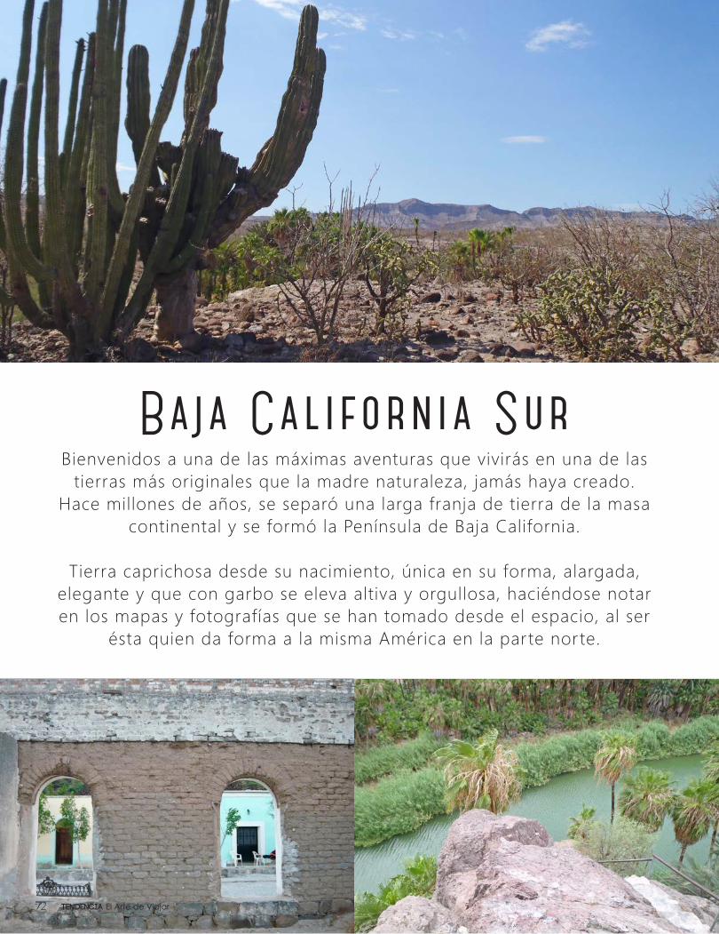
Baja California SurBienvenidos a una de las máximas aventuras que vivirás en una de las
tierras más originales que la madre naturaleza, jamás haya creado. Hace millones de años, se separó una larga franja de tierra de la masa
continental y se formó la Península de Baja California.
Tierra caprichosa desde su nacimiento, única en su forma, alargada, elegante y que con garbo se eleva altiva y orgullosa, haciéndose notar en los mapas y fotografías que se han tomado desde el espacio, al ser
ésta quien da forma a la misma América en la parte norte.
Tendencia El Arte de Viajar72
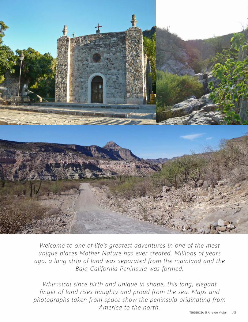
Welcome to one of life’s greatest adventures in one of the most unique places Mother Nature has ever created. Millions of years
ago, a long strip of land was separated from the mainland and the Baja California Peninsula was formed.
Whimsical since birth and unique in shape, this long, elegant finger of land rises haughty and proud from the sea. Maps and
photographs taken from space show the peninsula originating from America to the north.
73Tendencia El Arte de Viajar
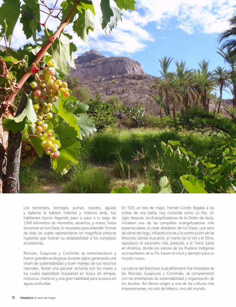
Los berrendos, borregos, pumas, coyotes, águilas y ballenas le habitan milenios y milenios atrás. Sus habitantes fueron llegando paso a paso a lo largo de 1,500 kilómetros de montañas, desiertos, y mares, hasta encontrar en los Oasis, lo necesario para extender formas de vida; las cuales representaron en magníficas pinturas rupestres que ilustran su adaptabilidad a los complejos ecosistemas.
Pericúes, Guaycuras y Cochimíes se entremezclaron y fueron grandes ecologistas durante siglos; generando una visión de sustentabilidad y buen manejo de sus recursos naturales. Tenían una peculiar armonía con los mares a los cuales explotaban buceando en busca de almejas, moluscos, mariscos y una gran habilidad para la pesca en aguas profundas.
En 1535 un tres de mayo, Hernán Cortés llegaba a las costas de una bahía, hoy conocida como La Paz. Un siglo después, los Evangelizadores de la Orden de Jesús, iniciaban una de las campañas evangelizadoras más espectaculares, al crear alrededor de los Oasis, una seria de obras de riego, infraestructuras y la construcción de las Misiones; donde buscaron, al manto de la Vid y el Olivo, reproducir el escenario más parecido a la Tierra Santa en América, donde los valores de los Pueblos Indígenas acompañados de su Fe, fuesen el crisol y ejemplo para un mundo nuevo.
La cultura del Ranchero Sudcaliforniano fue heredada de los Pericúes, Guaycuras y Cochimíes, se complementó con las enseñanzas de sustentabilidad y organización de los Jesuitas. Así dieron origen a una de las culturas más impresionantes, no solo de México, sino del mundo.
Tendencia El Arte de Viajar74
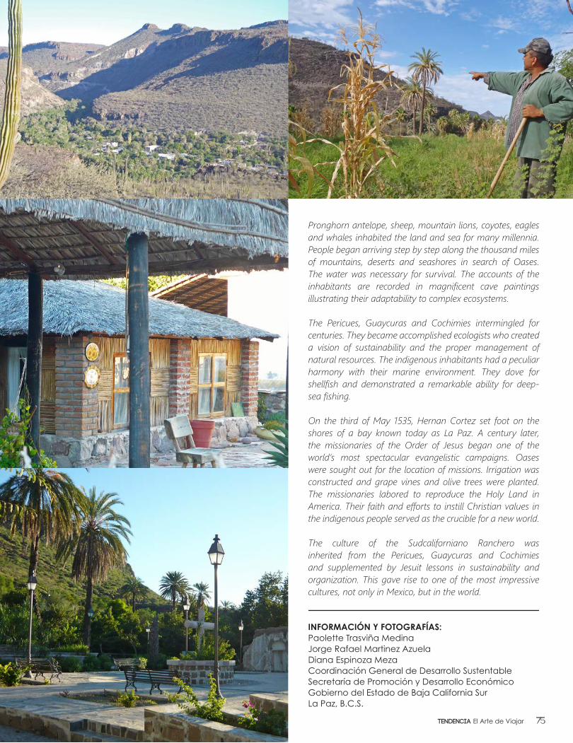
Pronghorn antelope, sheep, mountain lions, coyotes, eagles and whales inhabited the land and sea for many millennia. People began arriving step by step along the thousand miles of mountains, deserts and seashores in search of Oases. The water was necessary for survival. The accounts of the inhabitants are recorded in magnificent cave paintings illustrating their adaptability to complex ecosystems.
The Pericues, Guaycuras and Cochimies intermingled for centuries. They became accomplished ecologists who created a vision of sustainability and the proper management of natural resources. The indigenous inhabitants had a peculiar harmony with their marine environment. They dove for shellfish and demonstrated a remarkable ability for deep-sea fishing.
On the third of May 1535, Hernan Cortez set foot on the shores of a bay known today as La Paz. A century later, the missionaries of the Order of Jesus began one of the world’s most spectacular evangelistic campaigns. Oases were sought out for the location of missions. Irrigation was constructed and grape vines and olive trees were planted. The missionaries labored to reproduce the Holy Land in America. Their faith and efforts to instill Christian values in the indigenous people served as the crucible for a new world.
The culture of the Sudcaliforniano Ranchero was inherited from the Pericues, Guaycuras and Cochimies and supplemented by Jesuit lessons in sustainability and organization. This gave rise to one of the most impressive cultures, not only in Mexico, but in the world.
INFORMACIÓN Y FOTOGRAFÍAS: Paolette Trasviña MedinaJorge Rafael Martinez AzuelaDiana Espinoza MezaCoordinación General de Desarrollo SustentableSecretaría de Promoción y Desarrollo EconómicoGobierno del Estado de Baja California SurLa Paz, B.C.S.
75Tendencia El Arte de Viajar
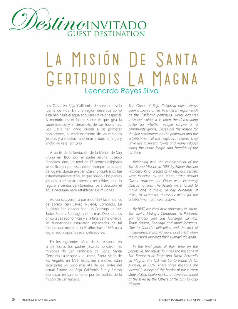
Leonardo Reyes Silva
La Misión De Santa Gertrudis La MagnaLos Oasis en Baja California siempre han sido fuente de vida. En una región desértica como esta península el agua adquiere un valor especial. A menudo es el factor sobre el que gira la supervivencia y el desarrollo de sus habitantes. Los Oasis han dado origen a las primeras poblaciones, al establecimiento de las misiones jesuitas y a muchas rancherías a todo lo largo y ancho de este territorio.
A partir de la fundación de la Misión de San Bruno en 1683 por el padre jesuita Eusebio Francisco Kino, un total de 17 centros religiosos se edificaron por esta orden siempre alrededor de lugares donde existían Oasis. Encontrarlos fue extremadamente difícil, lo que obligó a los padres jesuitas a efectuar extensos recorridos, por lo regular a cientos de kilómetros, para descubrir el agua necesaria para establecer sus misiones.
Así constituyeron, a partir de 1697 las misiones de Loreto, San Javier, Mulegé, Comondú, La Purísima, San Ignacio, San Luis Gonzaga, La Paz, Todos Santos, Santiago y otras más. Debido a las dificultades económicas y a la falta de misioneros, las fundaciones estuvieron espaciadas de tal manera que necesitaron 70 años, hasta 1767, para lograr sus propósitos evangelizadores.
En los siguientes años de su estancia en la península, los padres jesuitas fundaron las misiones de San Francisco de Borja, Santa Gertrudis La Magna y la última, Santa María de los Ángeles en 1776. Estas tres misiones están localizadas un poco más allá de los límites del actual Estado de Baja California Sur y fueron atendidas en su momento por los padres de la misión de San Ignacio.
The Oases of Baja California have always been a source of life. In a desert region such as the California peninsula, water acquires a special value. It is often the determining factor for whether people survive or a community grows. Oases are the reason for the first settlements on the peninsula and the establishment of the religious missions. They gave rise to several towns and many villages along the entire length and breadth of the territory.
Beginning with the establishment of the
San Bruno Mission in 1683 by Father Eusebio Francisco Kino, a total of 17 religious centers were founded by the Jesuit Order around Oases. However, the Oases were extremely difficult to find. The Jesuits were forced to make long journeys, usually hundreds of miles, to locate the necessary water for the establishment of their missions.
By 1697, missions were underway in Loreto,
San Javier, Mulege, Comondu, La Purisima, San Ignacio, San Luis Gonzaga, La Paz, Todos Santos, Santiago and other locations. Due to financial difficulties and the lack of missionaries, it was 70 years, until 1767, when the missions attained their evangelistic goals.
In the final years of their time on the
peninsula, the Jesuits founded the missions of San Francisco de Borja and Santa Gertrudis La Magna. The last was Santa Maria de los Angeles, in 1776. These three missions are located just beyond the border of the current state of Baja California Sur and were attended at the time by the fathers of the San Ignacio Mission.
DESTINO INVITADO - GUEST DESTINATIONTendencia El Arte de Viajar76

La historia de la misión de Santa Gertrudis La Magna es muy interesante. La mayoría de los historiadores, entre ellos Miguel León Portilla y Pablo L. Martínez apoyados en las crónicas del padre jesuita Miguel del Barco, aseguran que la misión la estableció en 1752 el padre Jorge Retz. En cambio, Carlos Lazcano dice que en realidad fue el sacerdote Fernando Consag el primero en instituirla en 1737, cuando el padre visitador de los jesuitas de la California, Andrés García, lo comisionó para establecer una nueva misión en la parte norte.
Lascano aclara que la confusión se debe al hecho de que los primeros 14 años, antes de que estuviera en su sitio actual, a esta misión se le apoyaba desde San Ignacio y se le conocía con el nombre de Nuestra Señora de los Dolores. Y aunque Fernando Consag la trasladó al sitio actual, quien empezó a atenderla fue el padre Retz a partir de 1752.
A poco de establecerse en la misión de Santa Gertrudis La Magna —narra Carlos Lazcano— el padre Retz dio principio a los trabajos agrícolas que le permitieron a la misión cierta autonomía. Encontró un manantial un poco más amplio y él construyó un canalito para regar la poca tierra de cultivo que se disponía. Construyó acequias y pilas que le permitieron sembrar y cosechar en poco tiempo. El maíz y el trigo florecieron junto con frutales como olivos, higos, granadas, uvas y dátiles. Con las uvas, el padre Retz elaboró los primeros vinos del norte peninsular, tradición que se conserva hasta nuestros días.
The history of Mission Santa Gertrudis La Magna is very interesting. Most historians, including Miguel Leon Portilla and Paul L. Martinez supported by the records of the Jesuit Father Miguel del Barco, claim Father Jorge Retz established the mission in 1752. In contrast, Carlos Lazcano said it was actually the priest Fernando Consag who founded the mission in 1737 when the Jesuit Father Visitor of California, Andrés García, commissioned him to establish a new mission in the northern region.
Lazcano clarifies that the
confusion is due to the fact that for 14 years before the mission was located at its current site, it was supported from San Ignacio and was known by the name of Our Lady of Sorrows. It was Fernando Consag who moved the mission to its present location in 1752 when he began serving Father Retz.
DESTINO INVITADO - GUEST DESTINATION 77Tendencia El Arte de Viajar
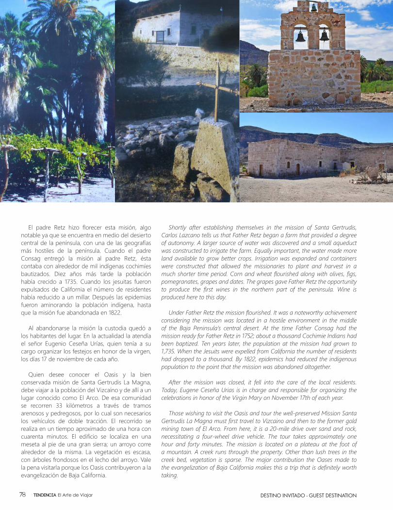
El padre Retz hizo florecer esta misión, algo notable ya que se encuentra en medio del desierto central de la península, con una de las geografías más hostiles de la península. Cuando el padre Consag entregó la misión al padre Retz, ésta contaba con alrededor de mil indígenas cochimíes bautizados. Diez años más tarde la población había crecido a 1735. Cuando los jesuitas fueron expulsados de California el número de residentes había reducido a un millar. Después las epidemias fueron aminorando la población indígena, hasta que la misión fue abandonada en 1822.
Al abandonarse la misión la custodia quedó a los habitantes del lugar. En la actualidad la atendía el señor Eugenio Ceseña Urías, quien tenía a su cargo organizar los festejos en honor de la virgen, los días 17 de noviembre de cada año.
Quien desee conocer el Oasis y la bien conservada misión de Santa Gertrudis La Magna, debe viajar a la población del Vizcaíno y de allí a un lugar conocido como El Arco. De esa comunidad se recorren 33 kilómetros a través de tramos arenosos y pedregosos, por lo cual son necesarios los vehículos de doble tracción. El recorrido se realiza en un tiempo aproximado de una hora con cuarenta minutos. El edificio se localiza en una meseta al pie de una gran sierra; un arroyo corre alrededor de la misma. La vegetación es escasa, con árboles frondosos en el lecho del arroyo. Vale la pena visitarla porque los Oasis contribuyeron a la evangelización de Baja California.
Shortly after establishing themselves in the mission of Santa Gertrudis, Carlos Lazcano tells us that Father Retz began a farm that provided a degree of autonomy. A larger source of water was discovered and a small aqueduct was constructed to irrigate the farm. Equally important, the water made more land available to grow better crops. Irrigation was expanded and containers were constructed that allowed the missionaries to plant and harvest in a much shorter time period. Corn and wheat flourished along with olives, figs, pomegranates, grapes and dates. The grapes gave Father Retz the opportunity to produce the first wines in the northern part of the peninsula. Wine is produced here to this day.
Under Father Retz the mission flourished. It was a noteworthy achievement considering the mission was located in a hostile environment in the middle of the Baja Peninsula’s central desert. At the time Father Consag had the mission ready for Father Retz in 1752; about a thousand Cochimie Indians had been baptized. Ten years later, the population at the mission had grown to 1,735. When the Jesuits were expelled from California the number of residents had dropped to a thousand. By 1822, epidemics had reduced the indigenous population to the point that the mission was abandoned altogether.
After the mission was closed, it fell into the care of the local residents. Today, Eugene Ceseña Urias is in charge and responsible for organizing the celebrations in honor of the Virgin Mary on November 17th of each year.
Those wishing to visit the Oasis and tour the well-preserved Mission Santa Gertrudis La Magna must first travel to Vizcaino and then to the former gold mining town of El Arco. From here, it is a 20-mile drive over sand and rock, necessitating a four-wheel drive vehicle. The tour takes approximately one hour and forty minutes. The mission is located on a plateau at the foot of a mountain. A creek runs through the property. Other than lush trees in the creek bed, vegetation is sparse. The major contribution the Oases made to the evangelization of Baja California makes this a trip that is definitely worth taking.
DESTINO INVITADO - GUEST DESTINATIONTendencia El Arte de Viajar78
Memorias por Siempre...
Capture Your Memories Forever...
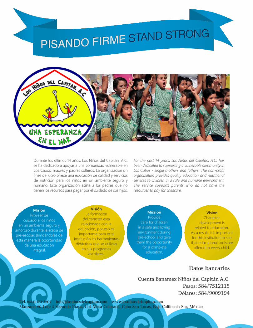
Datos bancarios
Cuenta Banamex Niños del Capitán A.C. Pesos: 584/7512115
Dólares: 584/9009194Tel. (624) 173-3807 [email protected] www.losninosdelcapitan.comManzana 89 Lote 5 Segunda Etapa, Col. Mesa Colorada, Cabo San Lucas, Baja California Sur, México.
Misión Proveer de
cuidado a los niños en un ambiente seguro y
amoroso durante la etapa de pre-escolar. Brindándoles de esta manera la oportunidad
de una educación integral.
Mission Provide
care for children in a safe and loving environment during pre-school and give
them the opportunity for a complete
education.
VisiónLa formación
del carácter está relacionada con la
educación, por eso es importante para esta
institución las herramientas didácticas que se utilizan
en sus programas escolares.
VisionCharacter
development is related to education.
As a result, it is important for this institution to see that educational tools are
offered to every child.
Durante los últimos 14 años, Los Niños del Capitán, A.C. se ha dedicado a apoyar a una comunidad vulnerable en Los Cabos, madres y padres solteros. La organización sin fines de lucro ofrece una educación de calidad y servicios de nutrición para los niños en un ambiente seguro y humano. Esta organización asiste a los padres que no tienen los recursos para pagar por el cuidado de sus hijos.
For the past 14 years, Los Niños del Capitan, A.C. has been dedicated to supporting a vulnerable community in Los Cabos - single mothers and fathers. The non-profit organization provides quality education and nutritional services to children in a safe and humane environment. The service supports parents who do not have the resources to pay for childcare.

Guiding you to a future of financial security
RP Consulting develops investment strategies that not only creates capital, but also protects and preserves it. We have provided our customers the highest levels of confidence for over 15 years. We believe the success of your financial future is created by personal and professional atention. We invite you to enjoy the benefits of the highest quality financial advisory services in the country with RP Consulting.
RP Consultores desarrolla estrategias de inversión que no sólo crea capital, sino también lo protege y lo conserva. Hemos brindado a nuestros clientes los más altos niveles de confianza durante más de 15 años. Creemos que el éxito de tu futuro financiero es creado por la atención personal y profesional. Te invitamos a disfrutar de los beneficios de la más alta calidad de servicios de asesoramiento financiero en el país con RP Consultores.
Guiándolos hacia un futuro
de seguridad financiera
Calle Miguel Hidalgo, Plaza Mediterránea 2do Piso L14Col. Matamoros 23468, Cabo San Lucas, BCSTel: 624 120 1276 / 77 · www.rp-consultores.com
Calle Salvatierra S/NFrente A Escuela NormalCol. Centro, Loreto, BCS 23880
Calle Viena 264 Int. 3Col. Versalles, Puerto Vallarta, Jalisco 48310

22
AÑ
O 2
014
TEN
DEN
CIA
EL A
RTE
DE V
IAJA
R