millennium ecosystem assessment eng... · resumen ejecutivo (millennium ecosystem assessment: ......
TRANSCRIPT

Millennium Ecosystem Assessment:
HUMAN WELL-BEING AND
SUSTAINABLE MANAGEMENT IN
SAN PEDRO DE ATACAMA - CHILE
EXECUTIVE SUMMARY
ONG Corporación RIDES Millennium Ecosystem Assessment www.rides.cl www.maweb.org
Project Advisory Committee*:
Ismael Aracena – Department of the Environment, SQM mining companyAldo Barrales – Indigenous Affairs Office, Corporación Nacional de Desarrollo Indígena (Chilean National Indigenous
Development Corporation) CONADI, II Region of AntofagastaDavid Barrera - Lodge Terrantai, inhabitant of San Pedro de Atacama
Alonso Barros – Director of the Archaeological Museum of San Pedro de AtacamaSandra Berna –Mayoress of San Pedro de Atacama
Juan Pablo Contreras - Director of CONAF (Chilean National Forests Corporation), II Region of AntofagastaPatricia de la Torre - Director of CONAMA (Chilean National Environment Commission), II Region of Antofagasta
Gustavo Herrera – SERNATUR (Chilean National Tourism Service), II Region of AntofagastaHonorio López - Atacameño community of Machuca
Jim Mallory - Superintendent of Sustainable Development, Compañía Minera ZaldívarMario Parada – Environmental Affairs Office, Minera Escondida Ltda.
Wilson Reyes – President of the Atacameño Peoples CouncilCarlos Sáez – Director of Operations, Sociedad Chilena del Litio
Juan Sota – inhabitant of San Pedro de Atacama, municipality councillorMarco Soto - Director of the General Water Department, II Region of Antofagasta
Guillermo Vega – President of the Asociación de Agricultores y Regantes (Agriculturers and Irrigators Association) of SanPedro de Atacama
Justo Zuleta – Area Coordinator of the Programa Orígenes, II Region
*The mission of the advisory committee was to work alongside the project and help to ensure that all viewpointswere considered in the assessment. Nevertheless, opinions expressed in this report are the sole responsibility ofthe project team and do not necessarily reflect those of the members of the advisory group. A rough draft of thisdocument was available for revision and comments by the group between 4 and 11 March, 2005. We thank the
group for the comments thus received.
Evaluación Ecosistémica del Milenio: Bienestar humano ymanejo sustentable en San Pedro de Atacama, Chile –Resumen ejecutivo (Millennium Ecosystem Assessment:Human well-being and sustainable management in San Pedrode Atacama, Chile – Executive report)RIDES
I.S.B.N.: 956-8370 - 02 - 1Copyright: 14 6051
Editing: Valeria TorresDesign and ilustration: Verónica ZuritaPrinted in Chile by Alerce Talleres Gráficos S.A.
This report is based on base line reports developed within theframework of the project “Human well-being and sustainablemanagement in San Pedro de Atacama” carried out by RIDES– Recursos e Investigación para el Desarrollo Sustentable(Research and Resources for Sustainable Development). Thisreport is a contribution to the Millennium EcosystemAssessment prepared by the Chilean Sub-Global AssessmentTeam. The report has been prepared and reviewed through aprocess approved by the MA Board but the report itself hasnot been accepted or approved by the Assessment Panel orthe MA Board. The project was financed by the MillenniumEcosystem Assessment (MA) with specific activities funded by:Minera Escondida Limitada, Compañía Minera Zaldívar, SQM,CONAF, Programa ORIGENES, Consejo de PueblosAtacameños, Universidad Técnica Federico Santa María andother diverse public and private organisations.
Financial support for the MA and the MA Sub-global Assess-ments was provided by the Global Environmental Facility(GEF), the United Nations Foundation, The David and LucilePackard Foundation, The World Bank, the United NationsEnvironment Programme (UNEP), the Government ofNorway, the Kingdom of Saudi Arabia, the Swedish Interna-tional Biodiversity Programme, The Rockefeller Foundation, theUnited States National Aeronautic and Space Administration(NASA), the International Council for Science (ICSU), the AsiaPacific Network for Global Change Research, The ChristensenFund, the United Kingdom Department for Environment, Foodand Rural Affairs (DEFRA), the Consultative Group for
International Agricultural Research (CGIAR), and The FordFoundation.
The project team consisted of the following people:
RIDES project team:Hernán Blanco, project directorAndrés Marín, coordinatorPatricio Pliscoff, research assistantBeatriz Bustos, research assistantVerónica Moreno, local coordinator
External team in charge of biodiversity base line study:Javier Simonetti, Executive Director of the ProgramaInterdisciplinario de Estudios sobre Biodiversidad or PIEB(Interdisciplinary Study Programme on Biodiversity),Universidad de Chile
External team in charge of base line study on water resources:Paolo Bevacqua, Aquaconsult
Support in the preparation of the executive summary.:Georgina Cundill, Southern African Millennium Assessment
Fotografías originales: Equipo RIDES and Paolo Bevacqua
Suggested reference:RIDES (2005). Bienestar humano y manejo sustentable enSan Pedro de Atacama, Chile – Resumen Ejecutivo (Humanwell-being and sustainable management in San Pedro deAtacama, Chile – Executive Summary), Santiago, Chile: RIDES.
This publication may be partially reproduced if referenced.Santiago, March 2005
RIDES is an independent research centre that seeks, throughits activities, to help generate public and private policy aimedat sustainable development.Andrés de Fuenzalida 22, Of. 801, Providencia, Santiago, ChileTelephone: (56-2) 2317565 / 2318716Fax: (56-2) 2320616Email: [email protected] - www.rides.cl
CONTENTS
Foreword 4
PART I – THE MILLENNIUM ECOSYSTEM ASSESSMENT
I.1. Human well-being and ecosystems: A framework for the assessment 7
PART II – HUMAN WELL-BEING AND SUSTAINABLE MANAGEMENT IN SAN PEDRO DE ATACAMA
II.1 Characteristics of the area 9
II.2 The focus of this initiative 12
PART III – ECOSYSTEM SERVICES IN SAN PEDRO DE ATACAMA
III.1 Water resources in the world’s driest desert 14
III.2 Tourism and local development: The promising gift of the ecosystem 21
III.3 Minerals in the desert: The enduring treasure 24
III.4 Biodiversity: The intangible key to ecosystem services 30
III.5 The Atacameño’s heritage: Agriculture and animal husbandry 34
III.6 The desert air is a window to the heavens 37
PART IV – SCENARIO-BUILDING FOR THE MUNICIPALITY OF SAN PEDRO DE ATACAMA
IV.1 What are scenarios? 40
IV.2 Creating scenarios 40
IV.3 The workshop on scenarios 41
PART V - RESPONSES FOR SUSTAINABLE MANAGEMENT AND HUMAN WELL-BEING
V.1 Social and administrative areas 43
V.2 Ecosystem services 46
V.3 Lessons and recommendations for future initiatives 50
PART VI – REFERENCES 51
42
40
14
9
6
4
FO
RE
WO
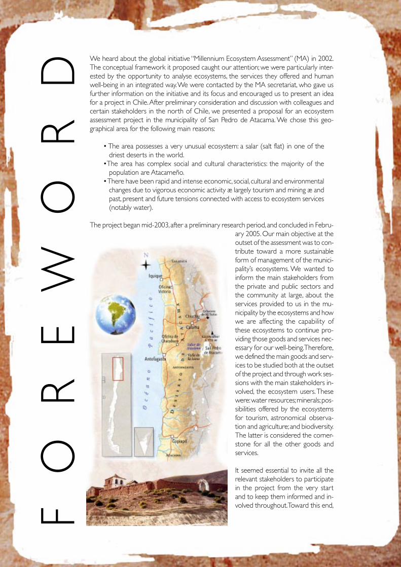
RD We heard about the global initiative “Millennium Ecosystem Assessment” (MA) in 2002.
The conceptual framework it proposed caught our attention; we were particularly inter-ested by the opportunity to analyse ecosystems, the services they offered and humanwell-being in an integrated way. We were contacted by the MA secretariat, who gave usfurther information on the initiative and its focus and encouraged us to present an ideafor a project in Chile. After preliminary consideration and discussion with colleagues andcertain stakeholders in the north of Chile, we presented a proposal for an ecosystemassessment project in the municipality of San Pedro de Atacama. We chose this geo-graphical area for the following main reasons:
• The area possesses a very unusual ecosystem: a salar (salt flat) in one of thedriest deserts in the world.
•The area has complex social and cultural characteristics: the majority of thepopulation are Atacameño.
• There have been rapid and intense economic, social, cultural and environmentalchanges due to vigorous economic activity æ largely tourism and mining æ andpast, present and future tensions connected with access to ecosystem services(notably water).
The project began mid-2003, after a preliminary research period, and concluded in Febru-ary 2005. Our main objective at theoutset of the assessment was to con-tribute toward a more sustainableform of management of the munici-pality’s ecosystems. We wanted toinform the main stakeholders fromthe private and public sectors andthe community at large, about theservices provided to us in the mu-nicipality by the ecosystems and howwe are affecting the capability ofthese ecosystems to continue pro-viding those goods and services nec-essary for our well-being. Therefore,we defined the main goods and serv-ices to be studied both at the outsetof the project and through work ses-sions with the main stakeholders in-volved, the ecosystem users. Thesewere: water resources; minerals; pos-sibilities offered by the ecosystemsfor tourism, astronomical observa-tion and agriculture; and biodiversity.The latter is considered the corner-stone for all the other goods andservices.
It seemed essential to invite all therelevant stakeholders to participatein the project from the very startand to keep them informed and in-volved throughout. Toward this end,
5
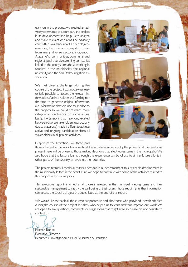
early on in the process, we elected an ad-visory committee to accompany the projectin its development and help us to analyseand make relevant decisions. The advisorycommittee was made up of 17 people, rep-resenting the relevant ecosystem usersfrom many diverse sectors: indigenousAtacameño communities, communal andregional public services, mining companieslinked to the ecosystems, those working intourism in the municipality, the regionaluniversity, and the San Pedro irrigation as-sociation.
We met diverse challenges during thecourse of the project. It was not always easyor fully possible to access the relevant in-formation. We had neither the funding northe time to generate original information(i.e. information that did not exist prior tothe project) so we could not reach morecategorical conclusions on some issues.Lastly, the tensions that have long existedbetween diverse stakeholders (particularlydue to water use) made it difficult to achieveactive and ongoing participation from allstakeholders in all project activities.
In spite of the limitations we faced, andthose inherent in the work team, we trust the activities carried out by this project and the results wepresent here will be of use to those making decisions that affect ecosystems in the municipality. Wealso hope that the lessons learnt through this experience can be of use to similar future efforts inother parts of the country or even in other countries.
The project team will continue, as far as possible, in our commitment to sustainable development inthe municipality. In fact, in the near future, we hope to continue with some of the activities related tothis project in the municipality.
This executive report is aimed at all those interested in the municipality ecosystems and theirsustainable management to satisfy the well-being of their users. Those requiring further informationcan access the specific project products, listed at the end of this report.
We would like to thank all those who supported us and also those who provided us with criticismduring the course of the project. It is they who helped us to learn and thus improve our work. Weare open to any questions, comments or suggestions that might arise so please do not hesitate tocontact us.
Hernán BlancoExecutive DirectorRecursos e Investigación para el Desarrollo Sustentable
6
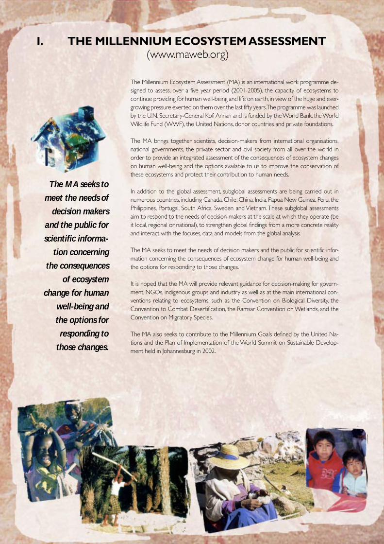
I. THE MILLENNIUM ECOSYSTEM ASSESSMENT(www.maweb.org)
The MA seeks to
meet the needs of
decision makers
and the public for
scientific informa-
tion concerning
the consequences
of ecosystem
change for human
well-being and
the options for
responding to
those changes.
The Millennium Ecosystem Assessment (MA) is an international work programme de-signed to assess, over a five year period (2001-2005), the capacity of ecosystems tocontinue providing for human well-being and life on earth, in view of the huge and ever-growing pressure exerted on them over the last fifty years. The programme was launchedby the U.N. Secretary-General Kofi Annan and is funded by the World Bank, the WorldWildlife Fund (WWF), the United Nations, donor countries and private foundations.
The MA brings together scientists, decision-makers from international organisations,national governments, the private sector and civil society from all over the world inorder to provide an integrated assessment of the consequences of ecosystem changeson human well-being and the options available to us to improve the conservation ofthese ecosystems and protect their contribution to human needs.
In addition to the global assessment, subglobal assessments are being carried out innumerous countries, including Canada, Chile, China, India, Papua New Guinea, Peru, thePhilippines, Portugal, South Africa, Sweden and Vietnam. These subglobal assessmentsaim to respond to the needs of decision-makers at the scale at which they operate (beit local, regional or national), to strengthen global findings from a more concrete realityand interact with the focuses, data and models from the global analysis.
The MA seeks to meet the needs of decision makers and the public for scientific infor-mation concerning the consequences of ecosystem change for human well-being andthe options for responding to those changes.
It is hoped that the MA will provide relevant guidance for decision-making for govern-ment, NGOs, indigenous groups and industry as well as at the main international con-ventions relating to ecosystems, such as the Convention on Biological Diversity, theConvention to Combat Desertification, the Ramsar Convention on Wetlands, and theConvention on Migratory Species.
The MA also seeks to contribute to the Millennium Goals defined by the United Na-tions and the Plan of Implementation of the World Summit on Sustainable Develop-ment held in Johannesburg in 2002.
7
GLOBAL
REGIONAL
LOCAL
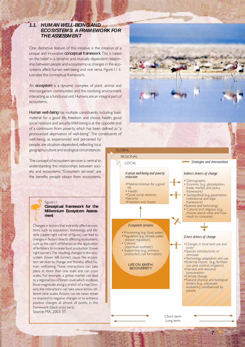
1.1. HUMAN WELL-BEING ANDECOSYSTEMS: A FRAMEWORK FORTHE ASSESSMENT
One distinctive feature of this initiative is the creation of aunique and innovative conceptual framework. This is basedon the belief in a dynamic and mutually dependent relation-ship between people and ecosystems; i.e. changes in the eco-systems affect human well-being and vice versa. Figure I.1 il-lustrates this conceptual framework.
An ecosystem is a dynamic complex of plant, animal andmicroorganism communities and the nonliving environmentinteracting as a functional unit. Humans are an integral part ofecosystems.
Human well-being has multiple constituents, including basicmaterial for a good life, freedom and choice, health, goodsocial relations and security. Well-being is at the opposite endof a continuum from poverty, which has been defined as “apronounced deprivation of well-being”. The constituents ofwell-being, as experienced and perceived bypeople, are situation-dependent, reflecting localgeography, culture and ecological circumstances.
The concept of ecosystem services is central tounderstanding the relationships between soci-ety and ecosystems. “Ecosystem services” arethe benefits people obtain from ecosystems.
Figure I.1:Conceptual framework for theMillennium Ecosystem Assess-ment
Changes in factors that indirectly affect ecosys-tems, such as population, technology, and life-style (upper right corner of figure), can lead tochanges in factors directly affecting ecosystems,such as the catch of fisheries or the applicationof fertilizers to increase food production (lowerright corner). The resulting changes in the eco-system (lower left corner) cause the ecosys-tem services to change and thereby affect hu-man well-being. These interactions can takeplace at more than one scale and can crossscales. For example, a global market can leadto a regional loss of forest cover, which increasesflood magnitude along a stretch of a river. Simi-larly, the interactions can take place across dif-ferent time scales. Actions can be taken eitherto respond to negative changes or to enhancepositive changes at almost all points in thisframework (black cross bars).Source: MA, 2003: 37.
Ecosystem services
• Provisioning (e.g., food, water)• Regulation (e.g., climate, water,
disease regulation)• Cultural
(espiritual, easthetic)• Supporting (e.g., primary,
production, soil formation)
LIFE ON EARTH:BIODIVERSITY
Indirect drivers of change
• Demographic• Econimic (e.g., globalization,
trade, market, and policyframework)
• Sociopolitical (e.g., governance,institutional, and legalframework)
•Science and technology• Cultural and religious (e.g.,
choices about what and howmuch to consume)
Direct drivers of change
•Changes in local land use andcover
•Species introductions orremovals
•Technology adaptation and use•External imputs (e.g., fertilizer
use, pest control, irrigation)•Harvest and resource
consumption•Climate change•Natural physical and biological
drivers (e.g., volcanoes,evolution), uninfluenced bypeople
Human well-being and povertyreduction
•Material minimun for a goodlife
• Health•Good social relations•Security•Freedom and choice
Strategies and interventions
Chort termLong term
8
These include tangible services, such as food, wood and wa-ter, and other intangible services, such as soil fertility, climateregulation and cultural values.
We all depend on the services provided by ecosystems, eventhough human well-being is also affected by other factors.Therefore, if we allow capacity of ecosystems to provide theseservices to deteriorate, sooner or later our well-being willsuffer.
Typically in ecosystem assessments, issues such as food pro-duction, potable water supply, fishing and conservation aretackled separately. In contrast, the MA examines all the ben-efits humans obtained from ecosystems in an integrated man-ner. It is designed to provide information for better under-standing of the relationships and commitments connected todecision-making with regard to the services an ecosystemprovides.
Appropriate policy-driven interventions can generally reduceor prevent ecosystem degradation and so increase the con-tribution of ecosystems to human well-being. However, sub-stantial knowledge of the ecological and social systems in-volved is required in order to determine when and how suchinterventions should be made. Top quality information doesnot guarantee better decisions, but it is a requisite for sounddecision-making processes.
The MA proposes that, in order to achieve an integratedecosystem assessment, it is necessary to describe the condi-tions and trends of ecosystem services and their relationshipto human well-being, as well as to identify direct and indirectfactors and drivers of change that affect both the ecosystemand the social context. Possible future scenarios can then beconstructed based on the above information, in order to iden-tify a set of responses to the current challenges and so achievemore adequate ecosystem management.
Lastly, the MA promotes the involvement of the ecosystemusers and the incorporation of their knowledge of the eco-system as a fundamental part of the local level assessments.The MA seeks in this way to give a direct and concrete re-sponse to the different needs and interests of decision-mak-ers, establishing bridges between scientific knowledge andpractical know-how.
The first MA report was published in 2003; an in-depth pres-entation of the aforementioned conceptual framework. Theassessment results at global and subglobal levels will be avail-able from May 2005.
The MA promotes the involvementof the ecosystem users and the
incorporation of their knowledge ofthe ecosystem as a fundamental
part of the local level assessments.The MA seeks in this way to give a
direct and concrete response to thedifferent needs and interests of
decision-makers, establishingbridges between scientific
knowledge and practical know-how.
9
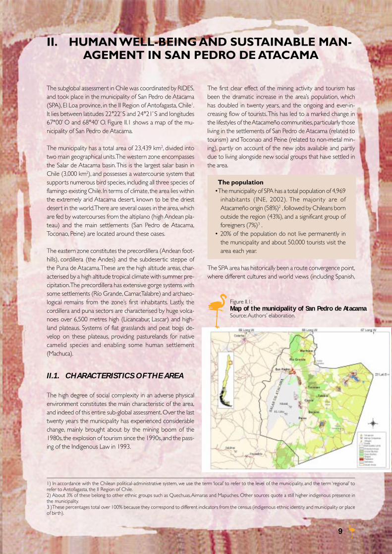
The subglobal assessment in Chile was coordinated by RIDES,and took place in the municipality of San Pedro de Atacama(SPA), El Loa province, in the II Region of Antofagasta, Chile1.It lies between latitudes 22°22’ S and 24°21’ S and longitudes67°00’ O and 68°40’ O. Figure II.1 shows a map of the mu-nicipality of San Pedro de Atacama.
The municipality has a total area of 23,439 km2, divided intotwo main geographical units. The western zone encompassesthe Salar de Atacama basin. This is the largest salar basin inChile (3,000 km2), and possesses a watercourse system thatsupports numerous bird species, including all three species offlamingo existing Chile. In terms of climate, the area lies withinthe extremely arid Atacama desert, known to be the driestdesert in the world. There are several oases in the area, whichare fed by watercourses from the altiplano (high Andean pla-teau) and the main settlements (San Pedro de Atacama,Toconao, Peine) are located around these oases.
The eastern zone constitutes the precordillera (Andean foot-hills), cordillera (the Andes) and the subdesertic steppe ofthe Puna de Atacama. These are the high altitude areas, char-acterised by a high altitude tropical climate with summer pre-cipitation. The precordillera has extensive gorge systems withsome settlements (Río Grande, Camar, Talabre) and archaeo-logical remains from the zone’s first inhabitants. Lastly, thecordillera and puna sectors are characterised by huge volca-noes over 6,500 metres high (Licancabur, Lascar) and high-land plateaus. Systems of flat grasslands and peat bogs de-velop on these plateaus, providing pasturelands for nativecamelid species and enabling some human settlement(Machuca).
II.1. CHARACTERISTICS OF THE AREA
The high degree of social complexity in an adverse physicalenvironment constitutes the main characteristic of the area,and indeed of this entire sub-global assessment. Over the lasttwenty years the municipality has experienced considerablechange, mainly brought about by the mining boom of the1980s, the explosion of tourism since the 1990s, and the pass-ing of the Indigenous Law in 1993.
Figure II.1:Map of the municipality of San Pedro de AtacamaSource: Authors’ elaboration.
The first clear effect of the mining activity and tourism hasbeen the dramatic increase in the area’s population, whichhas doubled in twenty years, and the ongoing and ever-in-creasing flow of tourists. This has led to a marked change inthe lifestyles of the Atacameño communities, particularly thoseliving in the settlements of San Pedro de Atacama (related totourism) and Toconao and Peine (related to non-metal min-ing), partly on account of the new jobs available and partlydue to living alongside new social groups that have settled inthe area.
The population•The municipality of SPA has a total population of 4,969
inhabitants (INE, 2002). The majority are ofAtacameño origin (58%)2 , followed by Chileans bornoutside the region (43%), and a significant group offoreigners (7%)3 .
• 20% of the population do not live permanently inthe municipality and about 50,000 tourists visit thearea each year.
The SPA area has historically been a route convergence point,where different cultures and world views (including Spanish,
1) In accordance with the Chilean political-administrative system, we use the term ‘local’ to refer to the level of the municipality, and the term ‘regional’ torefer to Antofagasta, the II Region of Chile.2) About 3% of these belong to other ethnic groups such as Quechuas, Aimaras and Mapuches. Other sources quote a still higher indigenous presence inthe municipality.3 )These percentages total over 100% because they correspond to different indicators from the census (indigenous ethnic identity and municipality or placeof birth).
II. HUMAN WELL-BEING AND SUSTAINABLE MAN-AGEMENT IN SAN PEDRO DE ATACAMA
10
Poverty• According to available data, in the year 2000, 14% of
the municipality’s population were classified as poor.This indicates a reduction in poverty since 1986 whenthis percentage was over 30% (MIDEPLAN). This trendcould have been influenced by the arrival of migrantsfrom higher socio-economic levels with different life-styles.
• For the year 2000, the average income per family inthe municipality was 320,000 Chilean pesos. This valueis below both the national average (64%) and theregional average (52%)4 . Nevertheless, the HumanDevelopment Index (UNDP) classifies the munici-pality’s income as “very high”.
• Social inequality is a key problem in Chile and studiessuggest that the gap between the wealthy and thepoor is particularly evident between the indigenouspopulation and the rest of the country (MIDEPLAN).
Local employment has enjoyed a gradual but constant trans-formation. SPA has shifted from being a municipality wherethe main activities were agriculture and livestock, to one wheremost of the labour force work in construction, mining andtourism. This has led to greater ‘monetarisation’ of people’slives and a distancing from the earth and its resources.
Employment• The main activities generating employment in the
municipality are directly or indirectly related to theuse of ecosystem services: construction (18%), ho-tels and restaurants (15%), and mining (11%).
• In 1982 agriculture represented about 32% of theEconomically Active Population in the municipality;in 1992 this figure only reached 21%. Tourism hasbeen the fastest growing sector in the last decade(10%).
• Amongst the Atacameño people, 9% of the workingpopulation are involved in agriculture.
The Indigenous Law laid down the foundations for a change inthe situation and long-awaited recognition of the indigenouspeoples by the government and Chilean society in general (BoxII.1). As a result of this law, the municipality was declared AtacamaLa Grande Indigenous Development Area and this has giventhe Atacameños greater control over their ancestral lands andthe use of public funds. The challenge for the Atacameños istwo-fold: to connect traditional production activities (agricul-ture, livestock, craftwork) with tourism and the economy ingeneral, through diversification and technology development;and to generate favourable conditions for them to participatein the services demanded by mining activities. In other words,
Box II.1:ATACAMEÑO IDENTITY IN THE PRESENT DAY*
Since the 1990s, following the passing of the Indigenous Law,the fact that existing indigenous communities manifest anidentity within the categories defined by the State has trig-gered two mutually-complementory processes: ethnogenesis(self-identification of a determined social group as part of anethnic group united by a shared mythical past); andethnification by the State (the construction of indigenousidentity by means of a political and legal process)(Gunderman, 2000).
Inserted into modernity through economic activity, the in-digenous communities of northern Chile are taking advan-tage of these “new political opportunities” to discover newmeaning in their identity in the following ways:• Revaluing of the “mythical past”, filling it with meaning for
the present and future,• Creation of formal indigenous organisations focused on
their rights and productivity,• Local development projects administered from an ethnic
viewpoint, abandoning the hitherto passive role in publicpolicy,
• New identity with regard to “others”,• Demands to recover lands and resources based on an-
cestral rights.
The Atacameño people demand the right to conserve andfoster their culture and strengthen their identity through therecognition, respect and promotion of their traditions andcultural and historical patrimony (Comisión para un NuevoTrato, 2003). This must begin by recognising the cultural andritual value of Patta Hoiri or mother earth and establishingthe inviolability of the guardian hills (cerros tutelares), waterresources and land of economic use to the Atacameños(pasturelands, herb-collecting lands, agriculture) and otherland of sacred and cultural value. However, this challengefaces growing disinterest from the younger generations re-garding their indigenous patrimony and culture.
*Extract from ”Patta hoiri and Likanantay people: rescuing theknowledge of the land”, Beatriz Bustos G., Hernán Blanco P.2004, document prepared for the MA conference “BridgingEpistemologies”, Alexandria, Egypt.
Chinese, Yugoslavs and Africans) come together, interact andare exchanged; the concept of “foreign” is far from new tolocal people living in this area. Nevertheless, mutual discrimi-nation, indifference and distrust cause constant rifts betweenthe different groups and block opportunities for develop-ment.
The new economic activities and significant public investmenthave helped alleviate poverty in SPA to the extent that in1996 it was removed from the list of 20 most poverty-strickenmunicipalities in Chile.
4) It should be noted that average income for the II Region is one of the highest in the country due to mining activity. However, this influence is notperceived in SPA.
11
the Atacameños must take advantage of the opportunitiesby revaluing their own identity in order to become a part oflocal development. This process has not been easy, however,due in large to the need for capacity development inindigenous organizations and leadership, and particularly inthe absence of a unified vision of the future that such ahuge challenge requires.
Opportunities for governance• In 1997 the SPA municipality was decreed an Indigenous
Development Area (Área de Desarrollo Indígena or ADI),representing a socio-territorial space for the State ad-ministrative bodies (including regional government, theNational Indigenous Development Commission orCONADI, the Ministry of Agriculture, the National StateProperty and the General Water Department) to focustheir action and resources on the harmonious develop-ment of the fourteen Atacameño Communities.
• The Indigenous Development Area is made up of threecommissions dealing with: social development, produc-tion development and land and water. Environmental is-sues are dealt with by a subcommission.
• There is scarce participation by the private sector or nonindigenous population, even when the Law allows it.
• In 2001 the Programa Orígenes was set up to offer sup-port to indigenous peoples in rural areas and to strengthenindigenous development areas (local and territorialparticipative planning processes, community projects, pro-duction projects, cultural projects and traditional medi-cine projects).
Tourism seems to be the preferred development option forboth the Atacameño communities and outsiders, be they resi-dent in the area or just passing through. This activity experi-enced sudden and unregulated growth triggered by the ar-rival of entrepreneurs who set up the first campsites andtourism agencies, followed by hostels and restaurants, andfinally diverse categories of hotels and internet cafés. At thestart of the 1990s, the communities began to realise thatlarge sums of money were being generated in the area, none
Box II.2:Main ecosystem users
Ecosystem users DescriptionAtacameño peoples 14 Atacameño communities, repre
sented in the Atacameño PeoplesCouncil); rural tourism network RedLikanhuasi.
Regional universities Archaeological Research Institute andMuseo R.P. Le Paige of the UniversidadCatólica del Norte; Universidad deAntofagasta.
Mining companies SQM, Sociedad Chilena del Litio,Minera Escondida Limitada, CompañíaMinera Zaldívar
Tourism operators Hotels, hostels, campsites, tourismand entrepreneurs agencies, internet cafés, etc.
Government authorities Regional government and localauthorities.
Public services Coordinated through the ADI:including CONADI (NationalIndigenous Development Corpora-tion), Programa ORIGENES –MIDEPLAN (Ministry of Planning),CONAF (National Forests Corporation), CONAMA (National Environ-ment Commission), DGA (GeneralWater Department), SERNATUR(National Tourism Service).
Astronomy Radioastronomy project ALMAobservatories (Atacama Large Millimeter Array) in
the Chajnantor valley.
Source: Authors’ elaboration.
of which were improving the standard of living of the land’sancestral ‘owners’. The Red Likanhuasi was established a dec-ade later, the first community-based tourism initiative and apioneer experience in co-management of tourist attractionswithin protected natural areas.
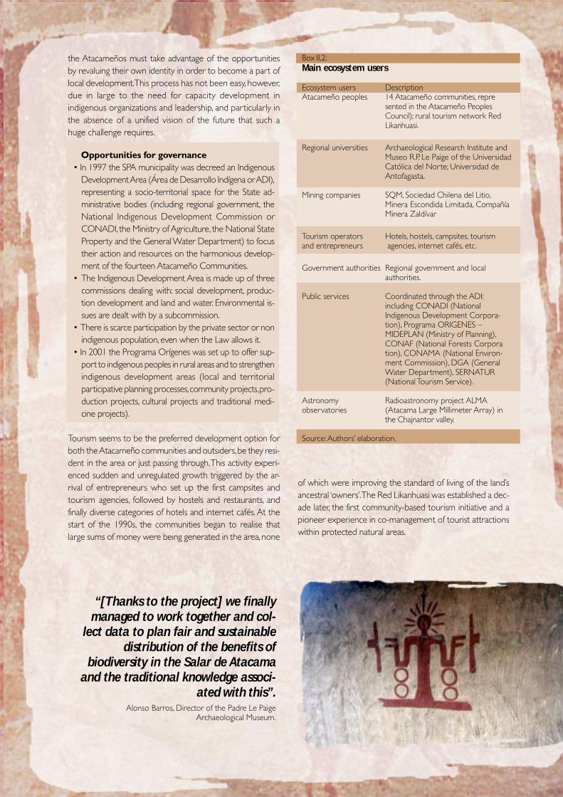
“[Thanks to the project] we finallymanaged to work together and col-
lect data to plan fair and sustainabledistribution of the benefits of
biodiversity in the Salar de Atacamaand the traditional knowledge associ-
ated with this”.Alonso Barros, Director of the Padre Le Paige
Archaeological Museum.
12
Public participation at the local level• The percentage of population participating in social
organisations (51%, MIDEPLAN) and the formal rateof community organisation (16,6 organisations per 1000inhabitants; National Municipal Information System) inSPA are among the highest in the region and the coun-try.
• However, according to available information and per-ceptions gathered, the degree and level of participa-tion (commitment) is fairly low (60% of the populationclaim they do not participate, PLADECO, 1999). Lackof leader credibility is one of the causes for this.
In this context, where legitimate indigenous demands, a highconcentration of government development initiatives, large-scale mining, an emerging tourism industry and globally-rel-evant astronomy projects all converge, it was a priority andconstant challenge throughout the initiative to generate dia-logue and trust between the different users and the projectteam (Box II.2). Establishing an advisory committee and set-ting up complementary participation activities for the com-munity were cornerstone to the whole assessment process(this issue is tackled in the following section).
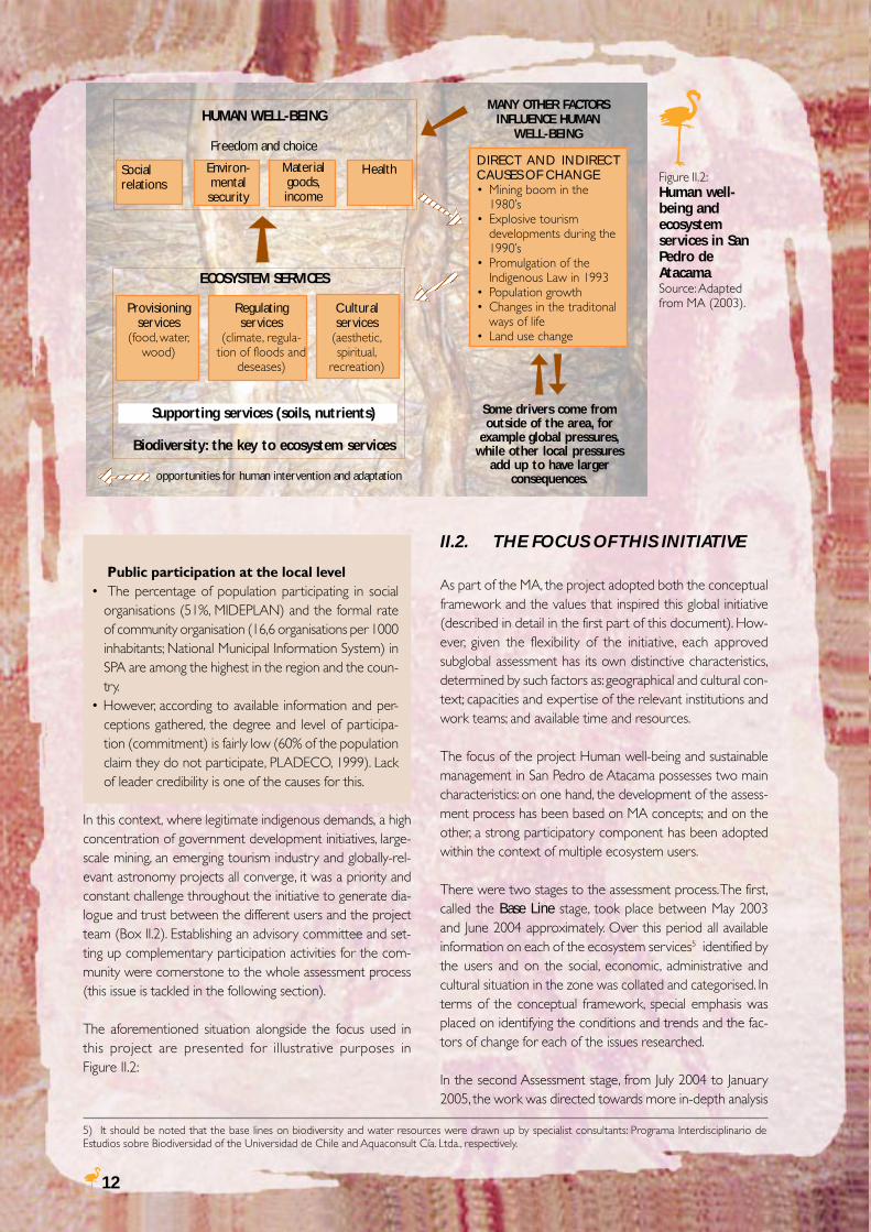
The aforementioned situation alongside the focus used inthis project are presented for illustrative purposes inFigure II.2:
II.2. THE FOCUS OF THIS INITIATIVE
As part of the MA, the project adopted both the conceptualframework and the values that inspired this global initiative(described in detail in the first part of this document). How-ever, given the flexibility of the initiative, each approvedsubglobal assessment has its own distinctive characteristics,determined by such factors as: geographical and cultural con-text; capacities and expertise of the relevant institutions andwork teams; and available time and resources.
The focus of the project Human well-being and sustainablemanagement in San Pedro de Atacama possesses two maincharacteristics: on one hand, the development of the assess-ment process has been based on MA concepts; and on theother, a strong participatory component has been adoptedwithin the context of multiple ecosystem users.
There were two stages to the assessment process. The first,called the Base Line stage, took place between May 2003and June 2004 approximately. Over this period all availableinformation on each of the ecosystem services5 identified bythe users and on the social, economic, administrative andcultural situation in the zone was collated and categorised. Interms of the conceptual framework, special emphasis wasplaced on identifying the conditions and trends and the fac-tors of change for each of the issues researched.
In the second Assessment stage, from July 2004 to January2005, the work was directed towards more in-depth analysis
5) It should be noted that the base lines on biodiversity and water resources were drawn up by specialist consultants: Programa Interdisciplinario deEstudios sobre Biodiversidad of the Universidad de Chile and Aquaconsult Cía. Ltda., respectively.
Figure II.2:Human well-being andecosystemservices in SanPedro deAtacamaSource: Adaptedfrom MA (2003).
HUMAN WELL-BEING
Freedom and choice
ECOSYSTEM SERVICES
Supporting services (soils, nutrients)
Biodiversity: the key to ecosystem services
opportunities for human intervention and adaptation
MANY OTHER FACTORSINFLUENCE HUMAN
WELL-BEING
Some drivers come fromoutside of the area, for
example global pressures,while other local pressures
add up to have largerconsequences.
123456781234567812345678
12345671234567123456712345671234567
Socialrelations
Environ-mentalsecurity
Materialgoods,income
Health
Provisioningservices
(food, water,wood)
Regulatingservices
(climate, regula-tion of floods and
deseases)
DIRECT AND INDIRECTCAUSES OF CHANGE• Mining boom in the
1980’s• Explosive tourism
developments during the1990’s
• Promulgation of theIndigenous Law in 1993
• Population growth• Changes in the traditonal
ways of life• Land use change
123456123456123456123456123456
Culturalservices
(aesthetic,spiritual,
recreation)
13
of water resources, the creation and development of sce-narios and the formulation of responses or recommenda-tions for sustainable management in SPA.
This research process would have been impossible withoutthe involvement and ongoing participation of the ecosystemusers. This component of the assessment enabled the pro-gressive development of opportunities for dialogue and re-ciprocal trust. The creation of the project advisory commit-tee proved to be the central axis of this process, offering aspace for governance to the seventeen participating repre-sentatives6 from the different user groups (a list of membersof the advisory committee is included at the beginning of thisreport): the Atacameño community, the public sector, localgovernment, tourism operators, mining companies and in-habitants of the municipality.
At the outset of the project the work team proposed thecreation of an advisory committee as a forum to:
• Provide and share information, knowledge and experiencebetween the members;• Express and integrate different perspectives and interests;• Generate trust and dialogue between relevant stakeholders;• Move beyond institutional boundaries and express and dis-cuss issues in a broader and more transparent way.
Seven meetings were held during the assessment process, inwhich the work team and advisory committee progressedthrough the stages and concepts of the assessment: trendsand conditions (discussion on base lines), factors of change(plenary dialogue), scenarios and responses (group workshop).Alongside this, the meetings gave opportunities for the par-ticipants and their respective institutions to present their in-terests and challenges regarding the ecosystem and humanwell-being. Researchers from abroad, working on othersubglobal assessments or coordinating the MA also partici-pated and gave presentations.
This advisory committee became the first and only instance inthe municipality in which multiple stakeholders have sat downtogether to discuss the important issues for local sustainabledevelopment from their different perspectives. The participantshave proposed to continue with the group after this initiative isover.
Apart from the advisory committee, the project also set up aseries of complementary activities, in alliance with numer-ous organisations and companies. These activities attemptedto make real contributions to the inhabitants of the munici-pality. Box II.3 describes the activities held in San Pedro deAtacama within the framework of the project.
6) It is important to point out that all meetings were open to the public and other interested persons and institutions were gradually integrated into thediscussions, constituting an important contribution to the debate.
Box II.3:
COMPLEMENTARY ACTIVITIES SET UP WITHIN THE FRAMEWORK OF THE PROJECT
Activity Description/ objective Participants/ beneficiaries Collaborators-Workshop -To identify the experiences, initiatives and concerns 10 leaders Atacameño Peopleswith of the Atacameño communities on ecosystem 6 professionals Council, CONAF,Atacameño management. Programa ORIGENESleaders -To present and discuss the project and conceptual
framework and methodology of the MA (with anemphasis on scenario-building) with the Atacameñocommunities.
-Trip with -Visit by a group of children from different settlements 109 children Municipal Educationchildren from in the municipality to Laguna Chaxa, in the Los 16 teachers and parents Department, Atacameñothe municipality Flamencos National Reserve and follow-up a talk on community of Toconao,to Laguna environmental education. CONAF, SQM, Cía.Chaxa -Complementary artistic modelling workshop in the Minera Zaldívar, Minera
children’s schools, with materials donated by the initiative. Escondida Ltda.
-Meetings and The video “Patta hoiri and Likanantay people: rescuing 30 elders Atacameño communitiesvideo on the knowledge of the land” records the two meetings 90 children and adolescents of SPA, Toconao andtraditional held in San Pedro de Atacama and Toconao, in Séquitor, Toconao primaryknowledge which Atacameño elders shared their memories, legends school
and traditions concerning the heavens, volcanoes, water andearth with children and adolescents from the community.
-Donation of -The project led to the donation of two solar water 11 in Camar Universidad Técnicatwo solar heating systems to the settlements of Machuca and 42 community initiative Federico Santa María,water heaters Camar, the former for a community tourism hostel and partners in Machuca Camar community,
the latter for a large low-income family. Programa ORIGENES-Follow-up on the economic, social and environmentalimpacts of these systems.
14
III. ECOSYSTEM SERVICES INSAN PEDRO DE ATACAMA
Ideally, the offer or availability of ecosystem services (e.g. wa-ter, tourist attractions or minerals) meets the demand or use,and existing use levels do not threaten the ability of ecosys-tem to provide those services in the future. Also, challengesto ecosystem services are associated not only with quantitybut also quality, and such services are needed at specific timesand places, which do not always coincide with availability. Thissection presents a summary of the situation for the mainecosystem services analysed in this project. Time and moneylimitations led the team to dedicate more resources towardsthe analysis of water resources, tourism and biodiversity.
III.1. WATER RESOURCES IN THEWORLD’S DRIEST DESERT7
The Salar de Atacama water basin is a closed system: Whatconsequences might this have now and in the future?
Being a closed system means that water within the basin canonly leave by evaporation and evapotranspiration or throughthe uses man makes of it. There is no outflow of water intoany other water basin or the sea.
In a closed basin, the difference between renewable and non-renewable water resources is not the same as in open basins;
in fact, any water extraction that takes place will have an ef-fect on the ecosystems involved.
The challenge is to find the method and volume of water usethat, on the one hand, satisfies the zone’s development needs,and on the other, does not have a strong or irreversible im-pact on the natural systems. Numerical simulations requirefurther data and interpretations before they can predict theeffects of exploitation with any real accuracy.
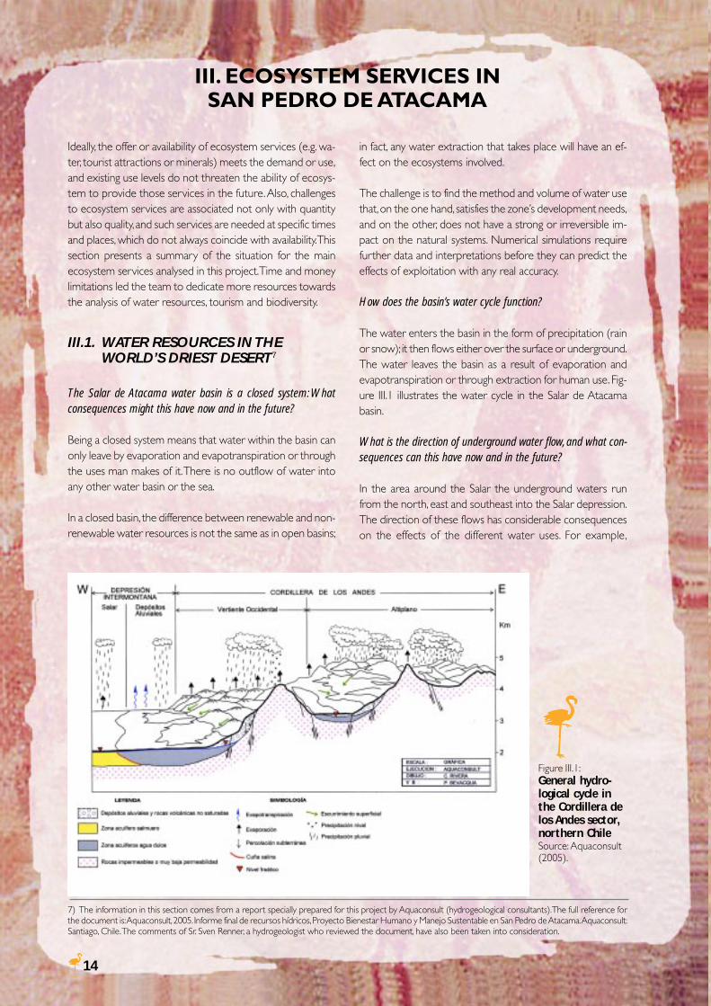
How does the basin’s water cycle function?
The water enters the basin in the form of precipitation (rainor snow); it then flows either over the surface or underground.The water leaves the basin as a result of evaporation andevapotranspiration or through extraction for human use. Fig-ure III.1 illustrates the water cycle in the Salar de Atacamabasin.
What is the direction of underground water flow, and what con-sequences can this have now and in the future?
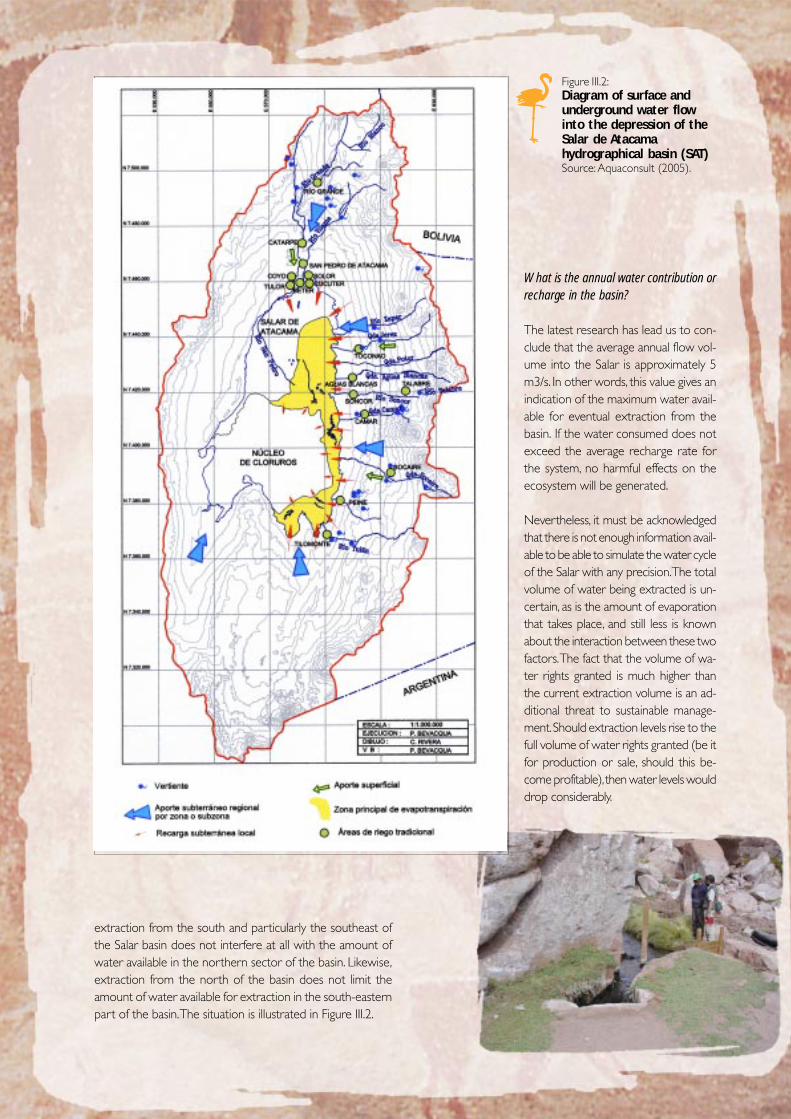
In the area around the Salar the underground waters runfrom the north, east and southeast into the Salar depression.The direction of these flows has considerable consequenceson the effects of the different water uses. For example,
Figure III.1:General hydro-logical cycle inthe Cordillera delos Andes sector,northern ChileSource: Aquaconsult(2005).
7) The information in this section comes from a report specially prepared for this project by Aquaconsult (hydrogeological consultants). The full reference forthe document is: Aquaconsult, 2005. Informe final de recursos hídricos, Proyecto Bienestar Humano y Manejo Sustentable en San Pedro de Atacama. Aquaconsult:Santiago, Chile. The comments of Sr. Sven Renner, a hydrogeologist who reviewed the document, have also been taken into consideration.
15
extraction from the south and particularly the southeast ofthe Salar basin does not interfere at all with the amount ofwater available in the northern sector of the basin. Likewise,extraction from the north of the basin does not limit theamount of water available for extraction in the south-easternpart of the basin. The situation is illustrated in Figure III.2.
Figure III.2:Diagram of surface andunderground water flowinto the depression of theSalar de Atacamahydrographical basin (SAT)Source: Aquaconsult (2005).
What is the annual water contribution orrecharge in the basin?
The latest research has lead us to con-clude that the average annual flow vol-ume into the Salar is approximately 5m3/s. In other words, this value gives anindication of the maximum water avail-able for eventual extraction from thebasin. If the water consumed does notexceed the average recharge rate forthe system, no harmful effects on theecosystem will be generated.
Nevertheless, it must be acknowledgedthat there is not enough information avail-able to be able to simulate the water cycleof the Salar with any precision. The totalvolume of water being extracted is un-certain, as is the amount of evaporationthat takes place, and still less is knownabout the interaction between these twofactors. The fact that the volume of wa-ter rights granted is much higher thanthe current extraction volume is an ad-ditional threat to sustainable manage-ment. Should extraction levels rise to thefull volume of water rights granted (be itfor production or sale, should this be-come profitable), then water levels woulddrop considerably.
16
How many water rights8 have been granted and in which sec-tors are they concentrated?
Within the hydrological basin of the Salar de Atacama 162water rights have been granted for a total of 6,223 l/s, distrib-uted between 2,234 l/s of surface water (73 rights) and 3,989l/s of underground water (89 rights). Surface water rights aremainly held in the north of the Salar, around San Pedro deAtacama, and in the east, whilst most of the undergroundwater rights are in the southeast of the basin.
In the altiplano of the municipality of San Pedro de Atacama, i.e.the basins lying to the east of the Salar basin, there are a furthertwenty surface water rights, for a total caudal of 2,770 l/s.
By comparing the rights granted (6.2 m3/s) with the water re-charge rate of the basin (about 5 m3/s) it can be seen that thevolume that could be extracted is on average greater than thatcoming in to the system. This is a sure call for concern. How-ever, it should be pointed out that extraction rates are onlyhigher than calculated recharge rates in the southeast of the
basin. This situation has been regulated by means of a specialagreement between users and the General Water Depart-ment (with an Early Warning Plan) and a restriction of waterflow. In spite of this, the system is very complex and compari-son between offer (recharge) and demand (use) is not thatsimple.
It should be noted that no water rights are required for brineextraction from the nucleus of the Salar, since this extractionfalls under the Mining Code. Table III.1 and Figure III.3 providea summary of the situation.
How many water rights are currently being requested and where?
To date, total requests for surface water rights are 3,277 l/sand for underground water rights 4,096 l/s. Surface waterrequests are mainly concentrated in the altiplano zone. Re-quests for underground water rights are concentrated in thealtiplano and the eastern and south-eastern areas of the Salar.Table III.1 and Figure III.3 indicate the amounts and locationsof the requests.
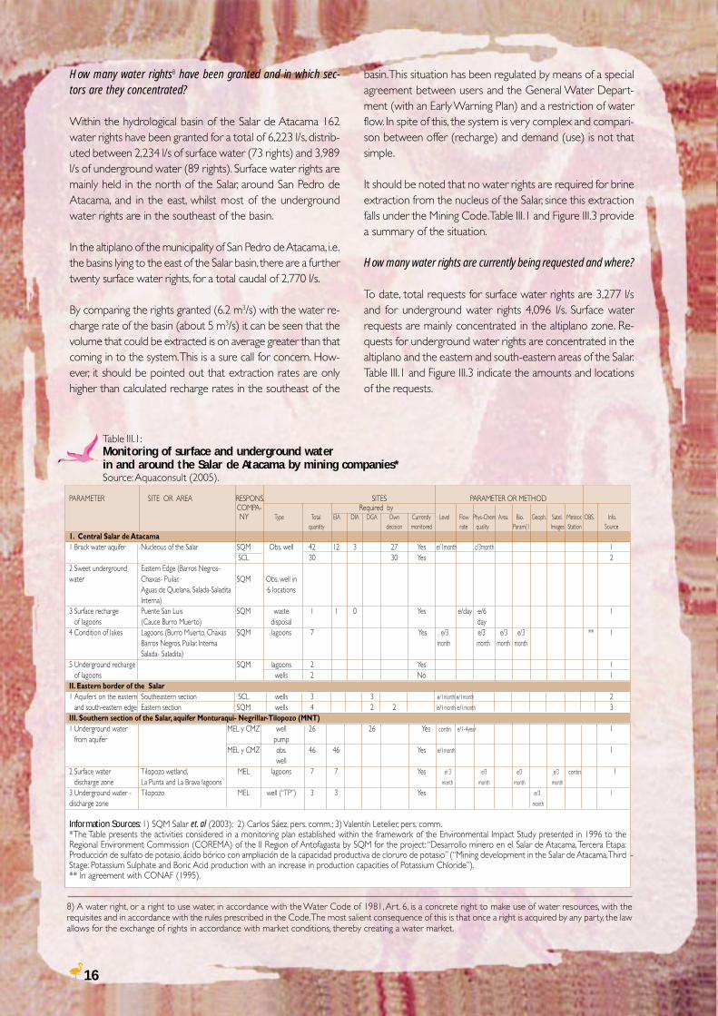
Table III.1:Monitoring of surface and underground waterin and around the Salar de Atacama by mining companies*Source: Aquaconsult (2005).
8) A water right, or a right to use water, in accordance with the Water Code of 1981, Art. 6, is a concrete right to make use of water resources, with therequisites and in accordance with the rules prescribed in the Code. The most salient consequence of this is that once a right is acquired by any party, the lawallows for the exchange of rights in accordance with market conditions, thereby creating a water market.
PARAMETER SITE OR AREA RESPONS. SITES PARAMETER OR METHOD COMPA- Required by
NY Type Total EIA DIA DGA Own Currently Level Flow Phys-Chem Area Bio. Geoph. Satel. Meteor. OBS. Info. quantity decision monitored rate quality Param(1 Images Station Source
1. Central Salar de Atacama1 Brack water aquifer Nucleous of the Salar SQM Obs. well 42 12 3 27 Yes e/1month c/3month 1
SCL 30 30 Yes 22 Sweet underground Eastern Edge (Barros Negros-water Chaxas- Puilar, SQM Obs. well in
Aguas de Quelana, Salada-Saladita 6 locationsInterna)
3 Surface recharge Puente San Luis SQM waste 1 1 0 Yes e/day e/6 1of lagoons (Cauce Burro Muerto) disposal day
4 Condition of lakes Lagoons (Burro Muerto, Chaxas SQM lagoons 7 Yes e/3 e/3 e/3 e/3 ** 1Barros Negros, Puilar, Interna month month month monthSalada- Saladita)
5 Underground recharge SQM lagoons 2 Yes 1of lagoons wells 2 No 1
II. Eastern border of the Salar1 Aquifers on the eastern Southeastern section SCL wells 3 3 e/1month e/1month 2
and south-eastern edge Eastern section SQM wells 4 2 2 e/1month e/1month 3III. Southern section of the Salar, aquifer Monturaqui- Negrillar-Tilopozo (MNT)1 Underground water MEL y CMZ well 26 26 Yes contin. e/1-4year 1
from aquifer pumpMEL y CMZ obs. 46 46 Yes e/1month 1
well2 Surface water Tilopozo wetland, MEL lagoons 7 7 Yes e/ 3 e/3 e/3 e/3 contin. 1
discharge zone La Punta and La Brava lagoons month month month month
3 Underground water - Tilopozo MEL well (“TP”) 3 3 Yes e/3 1
discharge zone month
Information Sources: 1) SQM Salar et. al (2003); 2) Carlos Sáez, pers. comm.; 3) Valentín Letelier, pers. comm.*The Table presents the activities considered in a monitoring plan established within the framework of the Environmental Impact Study presented in 1996 to theRegional Environment Commission (COREMA) of the II Region of Antofagasta by SQM for the project: “Desarrollo minero en el Salar de Atacama, Tercera Etapa:Producción de sulfato de potasio, ácido bórico con ampliación de la capacidad productiva de cloruro de potasio” (“Mining development in the Salar de Atacama, ThirdStage: Potassium Sulphate and Boric Acid production with an increase in production capacities of Potassium Chloride”).** In agreement with CONAF (1995).
17
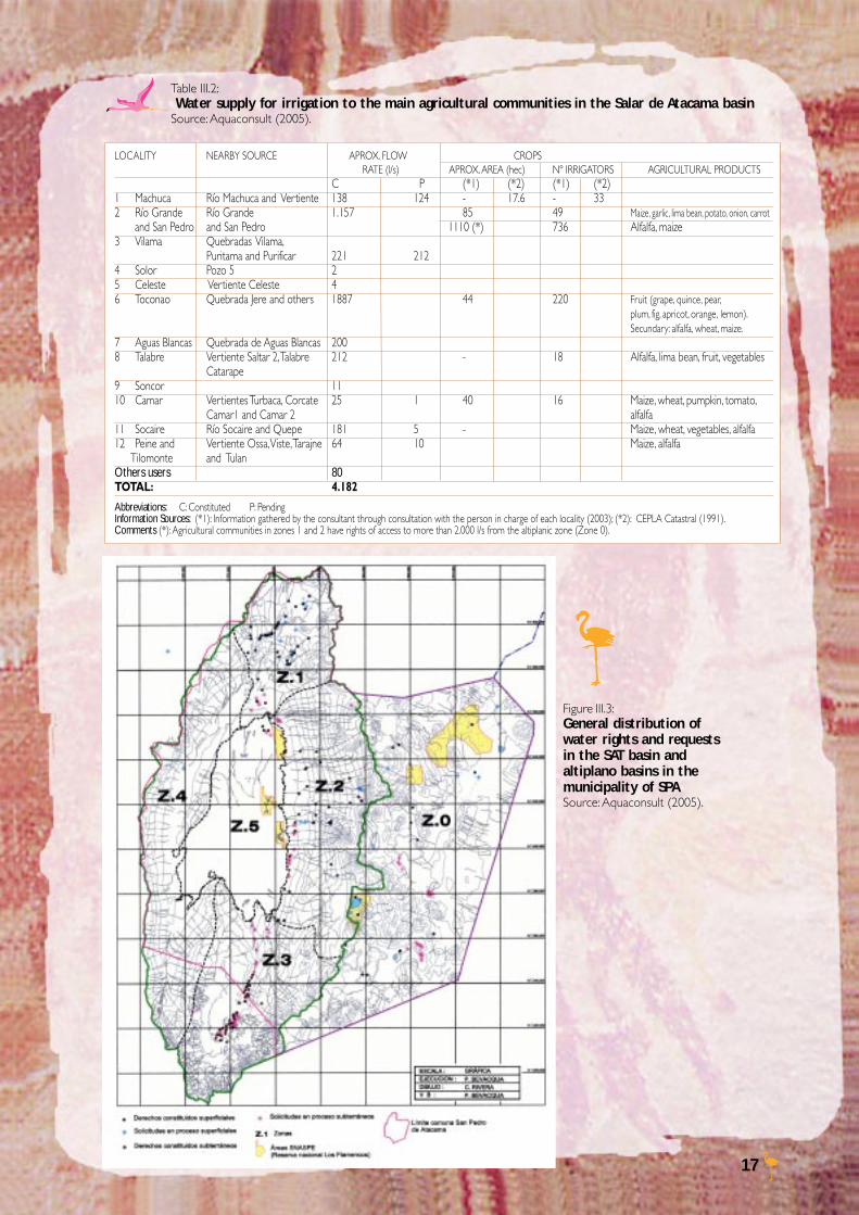
Table III.2: Water supply for irrigation to the main agricultural communities in the Salar de Atacama basinSource: Aquaconsult (2005).
LOCALITY NEARBY SOURCE APROX. FLOW CROPS RATE (l/s) APROX. AREA (hec) Nº IRRIGATORS AGRICULTURAL PRODUCTSC P (*1) (*2) (*1) (*2)
1 Machuca Río Machuca and Vertiente 138 124 - 17.6 - 332 Río Grande Río Grande 1.157 85 49 Maize, garlic, lima bean, potato, onion, carrot and San Pedro and San Pedro 1110 (*) 736 Alfalfa, maize3 Vilama Quebradas Vilama,
Puritama and Purificar 221 2124 Solor Pozo 5 25 Celeste Vertiente Celeste 46 Toconao Quebrada Jere and others 1887 44 220 Fruit (grape, quince, pear,
plum, fig, apricot, orange, lemon).Secundary: alfalfa, wheat, maize.
7 Aguas Blancas Quebrada de Aguas Blancas 2008 Talabre Vertiente Saltar 2, Talabre 212 - 18 Alfalfa, lima bean, fruit, vegetables
Catarape9 Soncor 1110 Camar Vertientes Turbaca, Corcate 25 1 40 16 Maize, wheat, pumpkin, tomato,
Camar1 and Camar 2 alfalfa11 Socaire Río Socaire and Quepe 181 5 - Maize, wheat, vegetables, alfalfa12 Peine and Vertiente Ossa, Viste, Tarajne 64 10 Maize, alfalfa Tilomonte and TulanOthers users 80TOTAL: 4.182
Abbreviations: C: Constituted P: PendingInformation Sources: (*1): Information gathered by the consultant through consultation with the person in charge of each locality (2003); (*2): CEPLA Catastral (1991).Comments (*): Agricultural communities in zones 1 and 2 have rights of access to more than 2.000 l/s from the altiplanic zone (Zone 0).
Figure III.3:General distribution ofwater rights and requestsin the SAT basin andaltiplano basins in themunicipality of SPASource: Aquaconsult (2005).
18
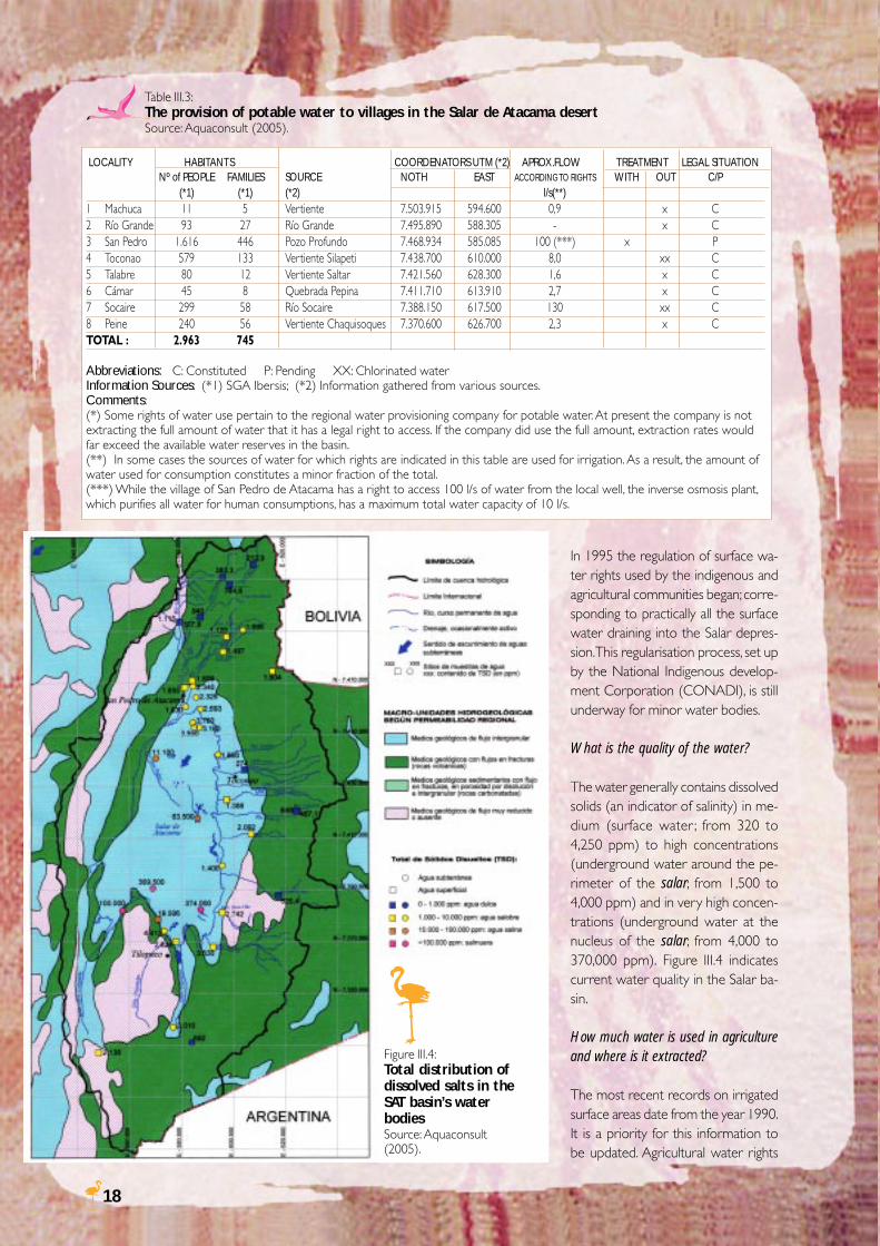
Table III.3:The provision of potable water to villages in the Salar de Atacama desertSource: Aquaconsult (2005).
In 1995 the regulation of surface wa-ter rights used by the indigenous andagricultural communities began; corre-sponding to practically all the surfacewater draining into the Salar depres-sion. This regularisation process, set upby the National Indigenous develop-ment Corporation (CONADI), is stillunderway for minor water bodies.
What is the quality of the water?
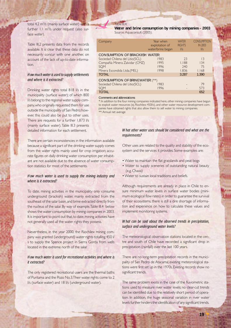
The water generally contains dissolvedsolids (an indicator of salinity) in me-dium (surface water ; from 320 to4,250 ppm) to high concentrations(underground water around the pe-rimeter of the salar; from 1,500 to4,000 ppm) and in very high concen-trations (underground water at thenucleus of the salar; from 4,000 to370,000 ppm). Figure III.4 indicatescurrent water quality in the Salar ba-sin.
How much water is used in agricultureand where is it extracted?
The most recent records on irrigatedsurface areas date from the year 1990.It is a priority for this information tobe updated. Agricultural water rights
LOCALITY HABITANTS COORDENATORS UTM (*2) APROX.FLOW TREATMENT LEGAL SITUATIONNº of PEOPLE FAMILIES SOURCE NOTH EAST ACCORDING TO RIGHTS WITH OUT C/P
(*1) (*1) (*2) l/s(**)1 Machuca 11 5 Vertiente 7.503.915 594.600 0,9 x C2 Río Grande 93 27 Río Grande 7.495.890 588.305 - x C3 San Pedro 1.616 446 Pozo Profundo 7.468.934 585.085 100 (***) x P4 Toconao 579 133 Vertiente Silapeti 7.438.700 610.000 8,0 xx C5 Talabre 80 12 Vertiente Saltar 7.421.560 628.300 1,6 x C6 Cámar 45 8 Quebrada Pepina 7.411.710 613.910 2,7 x C7 Socaire 299 58 Río Socaire 7.388.150 617.500 130 xx C8 Peine 240 56 Vertiente Chaquisoques 7.370.600 626.700 2,3 x CTOTAL : 2.963 745
Abbreviations: C: Constituted P: Pending XX: Chlorinated waterInformation Sources: (*1) SGA Ibersis; (*2) Information gathered from various sources.Comments:(*) Some rights of water use pertain to the regional water provisioning company for potable water. At present the company is notextracting the full amount of water that it has a legal right to access. If the company did use the full amount, extraction rates wouldfar exceed the available water reserves in the basin.(**) In some cases the sources of water for which rights are indicated in this table are used for irrigation. As a result, the amount ofwater used for consumption constitutes a minor fraction of the total.(***) While the village of San Pedro de Atacama has a right to access 100 l/s of water from the local well, the inverse osmosis plant,which purifies all water for human consumptions, has a maximum total water capacity of 10 l/s.
Figure III.4:Total distribution ofdissolved salts in theSAT basin’s waterbodiesSource: Aquaconsult(2005).
19
total 4.2 m3/s (mainly surface water) with afurther 1.1 m3/s under request (also sur-face water).
Table III.2 presents data from the recordsavailable. It is clear that these data do notnecessarily concur with one another, onaccount of the lack of up-to-date informa-tion.
How much water is used to supply settlementsand where is it extracted?
Drinking water rights total 818 l/s in themunicipality (surface water); of which 800l/s belong to the regional water supply com-pany, who originally requested them for useoutside the municipality of San Pedro; how-ever, this could also be put to other uses.There are requests for a further 1,873 l/s(mainly surface water). Table III.3 presentsdetailed information for each settlement.
There are certain inconsistencies in the information availablebecause a significant part of the drinking water supply comesfrom the water rights mainly used for crop irrigation; accu-rate figures on daily drinking water consumption per inhabit-ant are not available due to the absence of water consump-tion statistics for most of the settlements.
How much water is used to supply the mining industry andwhere is it extracted?
To date, mining activities in the municipality only consumeunderground (brackish) water, mainly extracted from thesoutheast of the salar basin, and brine extracted directly fromthe nucleus of the salar. By way of example, Table III.4 belowshows the water consumption by mining companies in 2003.It is important to point out that, to date, mining activities havenot generally used all the water rights they possess.
Nevertheless, in the year 2000, the Riochilex mining com-pany was granted (underground) water rights totalling 450 l/s to supply the Spence project in Sierra Gorda from wellslocated in the extreme north of the salar.
How much water is used for recreational activities and where isit extracted?
The only registered recreational users are the thermal bathsof Puritama and the Pozo No.3. Their water rights come to 2l/s (surface water) and 18 l/s (underground water).
What other water uses should be considered and what are therequirements?
Other uses are related to the quality and stability of the eco-system and the services it provides. Some examples are:
• Water to maintain the flat grasslands and peat bogs• Water to supply sceneries of outstanding natural beauty
(e.g. Chaxa)• Water to sustain local traditions and beliefs.
Although requirements are already in place in Chile to en-sure minimum water levels in surface water bodies (mini-mum ecological flow rates) in order to guarantee the survivalof their ecosystems, there is still a dire shortage of informa-tion and experience on how to calculate these values andimplement monitoring systems.
What can be said about the observed trends in precipitation,surface and underground water levels?
The meteorological observation stations located in the cen-tre and south of Chile have recorded a significant drop inprecipitation (rainfall) over the last 100 years.
There are no long-term precipitation records in the munici-pality of San Pedro de Atacama; existing meteorological sta-tions were first set up in the 1970s. Existing records show nosignificant trends.
The same problem exists in the case of the fluviometric sta-tions used to measure river water levels; no clear-cut trendscan be identified due to the relatively short period of opera-tion. In addition, the huge seasonal variation in river waterlevels further hinders the identification of any significant trends.
Table III.4:Water and brine consumption by mining companies - 2003Source: Aquaconsult (2005).
Company Year when WATER CONSUMPTIONexplotation of RIGHTS IN 2003
water/brine began l/s l/s
CONSUMPTION OF BRACKIISH WATER:Sociedad Chilena del Litio(SCL) 1983 23 13Compañía Minera Zalvidar (CMZ) 1995 1.188 134SQM 1996 240 75Minera Escondida Ltda.(MEL) 1998 1.836 1.168TOTAL 3.287 1.390
CONSUMPTION OF BRINE WATER: (**)Sociedad Chilena del Litio(SCL) 1983 - 79SQM 1996 - 573TOTAL 652
Comments and abbreviations:*: In addition to the four mining companies indicated here, other mining companies have begunto exploit water resources (ej. Riochilex: 450l/s), and other water resource development com-panies have obtained rights that also allow them to sell water to mining companies.**: Annual net average
20
Are the salt lakes of the Salar connected to the brine being ex-tracted by the SQM and SCL mining companies?
Rainfall in the Salar has an intense and immediate effect onbrine levels in the salt lakes. On account of this, rainfall is as-sumed to be the main source of recharge for brine, althoughthis needs to be confirmed through monitoring and futureinterpretations. Monitoring of the wells located in the salinenucleus of the Salar over the last eight years have backed upthe above assumption, with levels rising still higher than thoseat the outset of the monitoring period (1997).
Hydrological monitoring of the surface water bodies withinthe Salar, i.e. the Burro Muerto water channel, did not dem-onstrate any evidence of effects caused by water extractionfor mining activities up until 2002.
Has water extraction (particularly underground water extrac-tion) had any impact to date on the ecosystem in general andthe Salar´s salt lakes in particular?
Hydrological monitoring of water levels at the eastern edgeof the Salar has not recorded any effects of the pump extrac-tion used to supply mining activity. Nor has any effect beenrecorded, up until 2002, on the extraction through wells inthe salt lakes and nearby surroundings. These water bodiesare naturally characterised by low water levels.
In the Monturaqui-Negrillar sector declines in water levelshave been detected in accordance with hydrogeological mod-els of the aquifer under exploitation.
Up until 2002, after seven years of monitoring hydrologicaland hydrogeological data and other environmental param-eters, no negative impacts had been detected on lakes andwetlands or their fauna.
The monitoring period has included a period of drought andanother of abundant rainfall; these natural conditions haveallowed experts to research the response of the water sys-tems to natural variations. However, the study areas repre-sent very fragile ecosystems that are particularly sensitive to
water cycle changes, so monitoring mustcontinue; it would even be appropriateto increase the number of monitoring sites.The monitoring of the salt lakes and theirimmediate surroundings, both in the sa-line nucleus of the Salar and the fresh wa-ter aquifer system, must be paid particu-lar attention.
In spite of the above evidence, inhabit-ants in the area perceive changes in theecosystem (particularly regarding waterlevels in wells and water availability in the
rivers) but have no way to channel their concerns. Attemptscould be made to transform these undocumented percep-tions and memories into qualitative or semi quantitative data,validated and interpreted by scientific tools.
Could additional water extraction take place in the municipalityand in the Salar de Atacama (e.g. for new hotels or mining ven-tures)?
Generally speaking, when granting water rights in the SPAmunicipality, the General Water Department (DGA) havefollowed the criteria set down in the Water Code. In addition,in May 1999 the DGA drew up a document titled “Evaluaciónde la disponibilidad de recursos hídricos para constituirderechos de aprovechamiento en las subcuencas afluentes alSalar de Atacama, II Región” (“Assessment of the availabilityof water resources for allocation of rights of use in the sub-basins flowing into the Salar de Atacama, II Region”), with theaim of establishing whether further resources existed for al-locating new rights of use in the sectors of the basin.
The study was based on the (previously mentioned) divisionof the basin into five supply zones (Zones 1 to 5) and theSalar itself (Zone 6). The study concluded that renewableresources did exist, as listed in the table below.
It is evident from the aforementioned recharge figures thatwater availability is stretched in the municipality. For this rea-son, a detailed analysis, like that of the DGA, of each newrequirement must be carried out before any decisions can bemade.
How many tourists can the municipality receive without ex-ceeding water supply capacities?
There is not enough information available to answer thisquestion with any degree of certainty. There are certain in-consistencies between the information on water rights forthe settlements and the available records on effective wateruse. Accurate information on drinking water consumptionand resource availability is required urgently in order to es-timate how many people can effectively be supplied withpotable water. However, enlarging the (inverse osmosis)
Table III.5:Results of the calculations on renewable resourcesSource: Aquaconsult (2005).
ZONE SOURCES RENEWABLE RESOURCES (m3/sec.)Nº Area Surface Underground Total1 Extreme north 0,30 0,97 1,272 NE Border (until Qda. Sancor) 0,21 0,84 1,053 NE Border (between Camar u Tulán) 0,25 0,46 0,714 Monituraqui-Negriliar 0 0.88 0,885 Borde W (Qda. Agua Colorada and 0 0.03 0,03
Cordillera de la Sal)Total 3,946 Salar de Atacama
21
water purification plant for drinking water in San Pedro deAtacama is an even more important priority; current instal-lations can treat less than 10 l/s, while the plant’s capacityand water rights come to 100 l/s. It is also important totreat waste water to enable other uses, such as irrigation.
What does the future of water availability look like, and whatwill be the effect of climate change?
There is no systematic, well-founded information with whichto understand the effects of climate change. As stated above,significant progress is required concerning the quality andquantity of information on water in the municipality.
Clearly, if current water use levels and rights climb as ex-pected, there will not be enough water available to satisfy alluses (including ecosystem conservation).
III.2 TOURISM AND LOCALDEVELOPMENT: THE PROMISINGGIFT OF THE ECOSYSTEM9
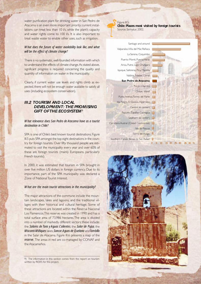
What relevance does San Pedro de Atacama have as a touristdestination in Chile?
SPA is one of Chile’s best known tourist destinations; FigureIII.5 puts SPA amongst the top eight destinations in the coun-try for foreign tourists. Over fifty thousand people are esti-mated to visit the municipality every year and over 60% ofthese are foreign tourists (mainly Europeans, particularlyFrench tourists).
In 2000, it was estimated that tourism in SPA brought inover five million US dollars in foreign currency. Due to itsimportance, part of the SPA municipality was declared aZone of National Tourist Interest.
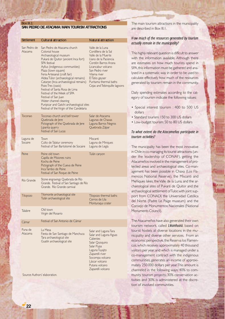
What are the main tourist attractions in the municipality?
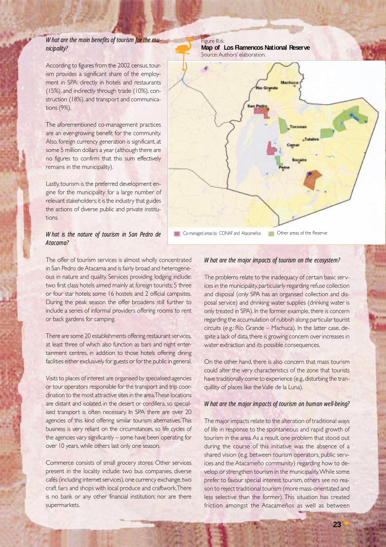
The major attractions of the commune include the moun-tain landscapes, lakes and lagoons, and the traditional vil-lages with their historical and cultural heritage. Some ofthese attractions are located within the Reserva NacionalLos Flamencos. This reserve was created in 1990 and has atotal surface area of 73,986 hectares. The area is dividedinto a number of markedly different sectors; these include:the Salares de Tara y Aguas Calientes, the Salar de Pujsa, theMiscanti-Miñiques lakes, Soncor, Aguas de Quelana and Tambilloin the Salar de Atacama. Figure III.6 presents a map of thereserve. The areas in red are co-managed by CONAF andthe Atacameños.
9) The information in this section comes from the report on tourismwritten by RIDES for this project.
Figure III.5:Chile: Places most visited by foreign touristsSource: Sernatur, 2002.
Santiago and around
Valparaíso, Viña del Mar, Reñaca
La Serena, Coquimbo
Puerto Montt, Puerto Varas
Arica, Putre, Lago Chungará
Iquique, Salitreras, Pica, Mantilla
Valdivia, Niebla, Corral
San Pedro de Atacama
Pucón, Villarrica
Chiloé Island
Punta Arenas, Torres del Paine
Isla Negra, El Quisco, Algarrobo
Central ski centers
Papudo, Zapallar, Cachagua
Southern ski centers
Carretera Austral (Chiloé Continental)
Isla de Pascua
Tierra del Fuego
Southern Canals, ferries to San Rafael0 5 10 15 20 25 30 35 40 %
22
Settlement
San Pedro deAtacama
Toconao
Laguna deSocaire
Peine
Río Grande
Tilopozo
Talabre
Cámar
Puna deAtacama
Cultural attraction
San Pedro de Atacama churchColonial houseArchaeological museumPukará de Quitor (ancient Inca fort)SPA festivalAyllus (indigenous communities)Plaza (town square)Feria Artesanal (craft fair)Aldea Túlor (archaeological remains)Catarpe (Inca archaeological remains)Pozo Tres (oasis)Festival of Santa Rosa de LimaFestival of the Week of SPAFestival of San JuanWater channel cleaningPuripicar and Gatchi archaeological sitesFestival of the Virgin of the Candelaria
Toconao church and bell towerQuebrada de JerePictograph of the Quebrada de JereLiparita quarryFestival of San Lucas
TownCulto de Talatur ceremonyFestival of San Bartolomé de Socaire
Peine old townCapilla de Misiones ruinsKocha de PeinePictograph of the Cueva de PeineInca Tambo de PeineFestival of San Roque de Peine
Stone engravings Quebrada de RíoGrande. Festival of San Santiago de RíoGrande. Río Grande carnival
Tilomonte archaeological siteTulán archaeological site
Old townVirgin del Rosario
Festival of San Antonio de Cámar
La MesaFiesta de San Santiago de ManchucaTara archaeological siteGuatín archaeological site
Natural attraction
Valle de la LunaCordillera de la SalValle de la MuerteLlano de la PacienciaCordón Barros AranaLicancabur volcanoSan Pedro riverVilama riverEl Tatio geyserPuritama thermal bathsCejas and Tebinquille lagoons
Salar de AtacamaLagunas de ChaxasLaguna Barros NegrosQuebrada Zápar
MiscantiLaguna de MiniquesLaguna de Legía
Tulán canyon
Tilopozo thermal bathsCerros de LilaMonturaqui crater
Salar and Laguna TaraSalar and Laguna AguasCalientesSalar QuisquiroSalar PujsaLaguna TuyajtoZaparelli riverSocompa volcanoLáscar volcanoPutana volcanoZaparelli volcano
The main tourism attractions in the municipalityare described in Box III.1.
How much of the resources generated by tourismactually remain in the municipality?
This highly relevant question is difficult to answerwith the information available. Although thereare estimates on how much tourists spend inSPA, this information must be gathered and ana-lysed in a systematic way in order to be used tocalculate effectively how much of the resourcesgenerated by tourism remain in the community.
Daily spending estimates according to the cat-egory of tourism indicate the following values:
• Special interest tourism : 400 to 500 USdollars
• Standard tourism: 150 to 300 US dollars• Low-budget tourism: 50 to 80 US dollars
To what extent do the Atacameños participate intourism activities?
The municipality has been the most innovativein Chile in co-managing its tourist attractions (un-der the leadership of CONAF), getting theAtacameños involved in the management of pro-tected areas and archaeological sites. Co-man-agement has been possible in Chaxa (Los Fla-mencos National Reserve), the Miscanti andMeñiques lakes, the Valle de la Luna, and the ar-chaeological sites of Pukará de Quitor and thearchaeological settlement of Tulor, with joint sup-port from CONADI, the Universidad Católicadel Norte (Padre Le Paige museum) and theConsejo de Monumentos Nacionales (NationalMonuments Council).
The Atacameños have also generated their owntourism network, called Likanhuasi, based ontourist hostels at diverse locations in the mu-nicipality and diverse other services. From aneconomic perspective, the Reserva los Flamen-cos, which receives approximately 40 thousandvisitors per year, and which is managed under aco-management contract with the indigenouscommunities, generates an income of approxi-mately 250.000 dollars per year. This amount ischanneled in the following ways: 40% to com-munity tourism projects, 30% conservation ac-tivities and 30% is administered at the discre-tion of involved communities.
Box III.1:SAN PEDRO DE ATACAMA: MAIN TOURISM ATTRACTIONS
Source: Authors’ elaboration.
23
What are the main benefits of tourism for the mu-nicipality?
According to figures from the 2002 census, tour-ism provides a significant share of the employ-ment in SPA: directly in hotels and restaurants(15%), and indirectly through trade (10%), con-struction (18%), and transport and communica-tions (9%).
The aforementioned co-management practicesare an ever-growing benefit for the community.Also, foreign currency generation is significant, atsome 5 million dollars a year (although there areno figures to confirm that this sum effectivelyremains in the municipality).
Lastly, tourism is the preferred development en-gine for the municipality for a large number ofrelevant stakeholders; it is the industry that guidesthe actions of diverse public and private institu-tions.
What is the nature of tourism in San Pedro deAtacama?
The offer of tourism services is almost wholly concentratedin San Pedro de Atacama and is fairly broad and heterogene-ous in nature and quality. Services providing lodging include:two first class hotels aimed mainly at foreign tourists; 5 threeor four star hotels; some 16 hostels and 2 official campsites.During the peak season the offer broadens still further toinclude a series of informal providers offering rooms to rentor back gardens for camping.
There are some 20 establishments offering restaurant services,at least three of which also function as bars and night enter-tainment centres, in addition to those hotels offering diningfacilities either exclusively for guests or for the public in general.
Visits to places of interest are organised by specialised agenciesor tour operators responsible for the transport and trip coor-dination to the most attractive sites in the area. These locationsare distant and isolated, in the desert or cordillera, so special-ised transport is often necessary. In SPA there are over 20agencies of this kind offering similar tourism alternatives. Thisbusiness is very reliant on the circumstances, so life cycles ofthe agencies vary significantly – some have been operating forover 10 years, while others last only one season.
Commerce consists of small grocery stores. Other servicespresent in the locality include: two bus companies, diversecafés (including internet services), one currency exchange, twocraft fairs and shops with local produce and craftwork. Thereis no bank or any other financial institution; nor are theresupermarkets.
Figure III.6:Map of Los Flamencos National ReserveSource: Authors’ elaboration.
What are the major impacts of tourism on the ecosystem?
The problems relate to the inadequacy of certain basic serv-ices in the municipality, particularly regarding refuse collectionand disposal (only SPA has an organised collection and dis-posal service) and drinking water supplies (drinking water isonly treated in SPA). In the former example, there is concernregarding the accumulation of rubbish along particular touristcircuits (e.g.: Río Grande – Machuca). In the latter case, de-spite a lack of data, there is growing concern over increases inwater extraction and its possible consequences.
On the other hand, there is also concern that mass tourismcould alter the very characteristics of the zone that touristshave traditionally come to experience (e.g., disturbing the tran-quillity of places like the Valle de la Luna).
What are the major impacts of tourism on human well-being?
The major impacts relate to the alteration of traditional waysof life in response to the spontaneous and rapid growth oftourism in the area. As a result, one problem that stood outduring the course of this initiative was the absence of ashared vision (e.g. between tourism operators, public serv-ices and the Atacameño community) regarding how to de-velop or strengthen tourism in the municipality. While someprefer to favour special interest tourism, others see no rea-son to reject traditional tourism (more mass-orientated andless selective than the former). This situation has createdfriction amongst the Atacameños as well as between
Co-managed areas by CONAF and Atacameños Other areas of the Reserve

24
Atacameños and other members of the community.
The precarious nature of the employment is another prob-lem associated with tourism. Unfortunately, due to the na-ture of the social surveys, there is not enough informationavailable to quantify or characterise this situation. Neverthe-less, people familiar with the sector give clear testimony ofthe informal nature of the labour conditions.
How many tourists could visit the attractions of SPA withoutcausing degradation?
There is no substantial consistent information; only a few uni-versity theses have tried to give estimates for some specificsites, such as Chaxas (in the Los Flamencos National Reserve).In order to answer this question the priority sites (i.e. thosemost in need of control and regulating) must first be selectedand then analysed for “load capacity” (or something similar).There is currently one project underway (led by EUROCHILE)that will tackle this issue, amongst others.
What are the main challenges facing sustainable tourism?
To start with it is necessary to validate, consolidate andimplement a tourism development strategy for the munici-pality with a strong component aimed at strengthening in-digenous local organizations involved in tourism. The diversestakeholders, including the Atacameño Peoples Council,SERNATUR, local government and the Atacama La GrandeIndigenous Development Area, are all aware of this needand are taking steps to fulfil it.
On the other hand, the quality of tourism services on offer(e.g. hotels, restaurants, transport services and tourist guides)in the municipality must be improved and regulated. Onealternative with an increasingly strong international followingis the certification of services. Certification could fulfil tworoles: to raise and regulate service quality and to ensure serv-ice sustainability.
What are the aspirations for tourism in the municipality?
This question triggers considerable discussion between rel-evant stakeholders. There are diverse viewpoints on how tour-ism in the municipality should be developed and strength-ened.
Some of the challenges that need to be tackled include: thelack of coordination, administrative powers and representa-tion of the private sector; and the as yet incipient role playedby the Atacameños.
Within this context, the ADI Atacama La Grande couldconsitute a fundamental actor in strengthening the adminis-tration of tourism by indigenous communities.
III.3. MINERALS IN THE DESERT:THE ENDURING TREASURE
Is mining a service provided by the ecosystem?
If we take the definition of an ecosystem service provided bythe broader Millennium Ecosystem Assessment, namely “allthose benefits we obtain from the ecosystems”, mineral ex-ploitation is without a doubt one such benefit. It is the abioticcharacteristic of this ecosystem that allows minerals in suffi-cient quality and quantity to make mining both desirable andfeasible. Nevertheless, unlike other ecosystem services, thisservice is finite and of limited capacity. Minerals are a finite,non-renewable resource; consequently, today’s mining activ-ity will at some stage come to an end or make way for an-other. The problem boils down to a decision on how to usethis service: when to exploit the minerals and to what de-gree. In Chile, as in most countries, this decision depends onthe market, subject to valid legal conditions.
How important are mining activities in this region and in the restof the country?
Historically mining has always held a key position in the coun-try and it continues to do so today. In spite of diversificationin the Chilean economy, mining is still the largest economicsector: totalling almost 10% of Gross Domestic Product (GDP)and 50% of exports. In 2000, in the Antofagasta region, min-ing represented over 60% of the regional GDP; it is the re-gion with the most mining activity in Chile (MMSD SouthAmerica team, 2002).
The Antofagasta Regional Development Strategy recognisesmining as one of the main sources of economic activity anddevelopment, but it also acknowledges the activity’s weak-nesses due to the use of non-renewable resources and itslimited influence on local employment. On account of this,the development of a cluster has been proposed, based onmining but generating new activities that provide more re-sources and employment in the region. Table III.6 lists statisticson population numbers and employment in the region.
It should be highlighted that mining in the region experienceda 9.2% annual growth rate between 1988 and 1999, far higherthan in the rest of the country (SERNAGEOMIN, 2003). Thistrend can be seen in Figure III.7.
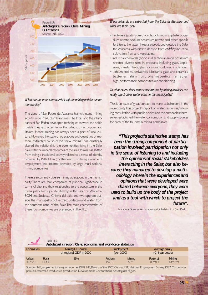
25
What are the main characteristics of the mining activities in themunicipality?
The zone of San Pedro de Atacama has witnessed miningactivity since Pre-Columbian times. The Incas and the inhab-itants of San Pedro developed techniques to work the noblemetals they extracted from the salar, such as copper andlithium. Hence, mining has always been a part of local cul-ture. However, the scale of operations and quantities of ma-terial extracted by so-called “new mining” has drasticallyaltered the relationship the communities living in the Salarhave with the mineral resources of the area. Mining has shiftedfrom being a traditional activity related to a sense of identityprovided by Patta Hoiri (mother earth), to being a source ofemployment and income provided by large multi-nationalmining companies.
There are currently diverse mining operations in the munici-pality. There are four companies of principal significance interms of size and their relationship to the ecosystem in themunicipality. Two operate directly in the Salar de Atacama:SQM and Sociedad Chilena del Litio; and two operate out-side the municipality but extract underground water fromthe southern zone of the Salar. The main characteristics ofthese four companies are presented in Box III.2.
What minerals are extracted from the Salar de Atacama andwhat are their uses?
• Fertilizers (potassium chloride, potassium sulphate, potas-sium nitrate, sodium potassium nitrate and other specificfertilizers; the latter three are produced outside the Salarthe Atacama with nitrate derived from caliche): industrialcultivation, fruit and vegetables.
• Industrial chemicals (boric acid, technical-grade potassiumnitrate): diverse uses in products, including glass, explo-sives, transfer fluids, glass fibres and cellulosic insulation.
• Lithium and its derivatives: lubricants, glass and ceramics,batter ies, aluminium, pharmaceutical remedies,high-performance composites, air conditioning,
To what extent does water consumption by mining activities cur-rently affect other water users in the municipality?
This is an issue of great concern to many stakeholders in themunicipality. This project’s report on water resources, follow-ing consultation with public bodies and the companies them-selves, established the water consumption and supply sourcesfor each of the four main mining companies.
Table III.6:Antofagasta region, Chile: economic and workforce statistics
Population Mining GDP as % Employment Average salaryof regional GDP in 2000 (per 1000) (Chilean pesos)
Urban Rural 65% Regional Mining Regional Mining482,546 11,438 159,3 22,9 317,913 649,269
Sources: INE, supplement survey on income, 1998. INE, Results of the 2002 Census. INE, National Employment Survey, 1997. Corporaciónpara el Desarrollo Productivo (Production Development Corporation), Antofagasta region.
Figure III.7:Antofagasta region, Chile: MiningGDP trendsSource: INE, 2002.
800
750
700
650
600
550
500
1996 1997 1998 1999 2000 2001 2002
Billio
n p
esos
“This project’s distinctive stamp hasbeen the strong component of partici-pation involved; participation not only
in the sense of listening to and includingthe opinions of social stakeholders
interacting in the Salar, but also be-cause they managed to develop a meth-
odology wherein the experiences andopinions that were developed were
shared between everyone; they wereused to build up the body of the projectand as a tool with which to project the
future”.Francisca Greene, Anthropologist, inhabitant of San Pedro.
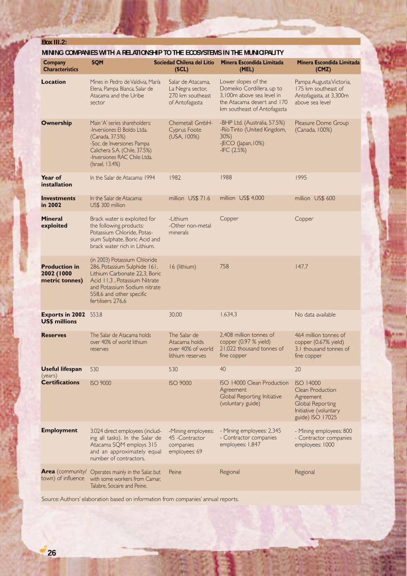
26
Source: Authors’ elaboration based on information from companies’ annual reports.
Location
Ownership
Year ofinstallation
Investmentsin 2002
Mineralexploited
Production in2002 (1000metric tonnes)
Exports in 2002US$ millions
Reserves
Useful lifespan(years)Certifications
Employment
Area (community/town) of influence
Box III.2:
MINING COMPANIES WITH A RELATIONSHIP TO THE ECOSYSTEMS IN THE MUNICIPALITYCompany SQM Sociedad Chilena del Litio Minera Escondida Limitada Minera Escondida LimitadaCharacteristics (SCL) (MEL) (CMZ)
Mines in Pedro de Valdivia, MaríaElena, Pampa Blanca, Salar deAtacama and the Uribesector
Main ‘A’ series shareholders:-Inversiones El Boldo Ltda.(Canada, 37.5%)-Soc. de Inversiones PampaCalichera S.A. (Chile, 37.5%)-Inversiones RAC Chile Ltda.(Israel, 13.4%)
In the Salar de Atacama: 1994
In the Salar de Atacama:US$ 300 million
Brack water is exploited forthe following products:Potassium Chloride, Potas-sium Sulphate, Boric Acid andbrack water rich in Lithium.
(in 2003) Potassium Chloride286, Potassium Sulphide 161,Lithium Carbonate 22,3, BoricAcid 11,3 , Potassium Nitrateand Potassium Sodium nitrate558,6 and other specificfertilisers 276,6
553,8
The Salar de Atacama holdsover 40% of world lithiumreserves
530
ISO 9000
3.024 direct employees (includ-ing all tasks). In the Salar deAtacama SQM employs 315and an approximately equalnumber of contractors.
Operates mainly in the Salar, butwith some workers from Camar,Talabre, Socaire and Peine.
Salar de Atacama,La Negra sector,270 km southeastof Antofagasta
Chemetall GmbH-Cyprus Foote(USA, 100%)
1982
million US$ 71.6
-Lithium-Other non-metalminerals
16 (lithium)
30,00
The Salar deAtacama holdsover 40% of worldlithium reserves
530
ISO 9000
-Mining employees:45 -Contractorcompaniesemployees: 69
Peine
Lower slopes of theDomeiko Cordillera, up to3,100m above sea level inthe Atacama desert and 170km southeast of Antofagasta
-BHP Ltd. (Australia, 57.5%)-Río Tinto (United Kingdom,30%)-JECO (Japan,10%)-IFC (2.5%)
1988
million US$ 4,000
Copper
758
1.634,3
2,408 million tonnes ofcopper (0.97 % yield)21,022 thousand tonnes offine copper
40
ISO 14000 Clean ProductionAgreementGlobal Reporting Initiative(voluntary guide)
- Mining employees: 2,345- Contractor companiesemployees: 1,847
Regional
Pampa Augusta Victoria,175 km southeast ofAntofagasta, at 3,300mabove sea level
Pleasure Dome Group(Canada, 100%)
1995
million US$ 600
Copper
147.7
No data available
464 million tonnes ofcopper (0.67% yield)3.1 thousand tonnes offine copper
20
ISO 14000Clean ProductionAgreementGlobal ReportingInitiative (voluntaryguide) ISO 17025
- Mining employees: 800- Contractor companiesemployees: 1000
Regional
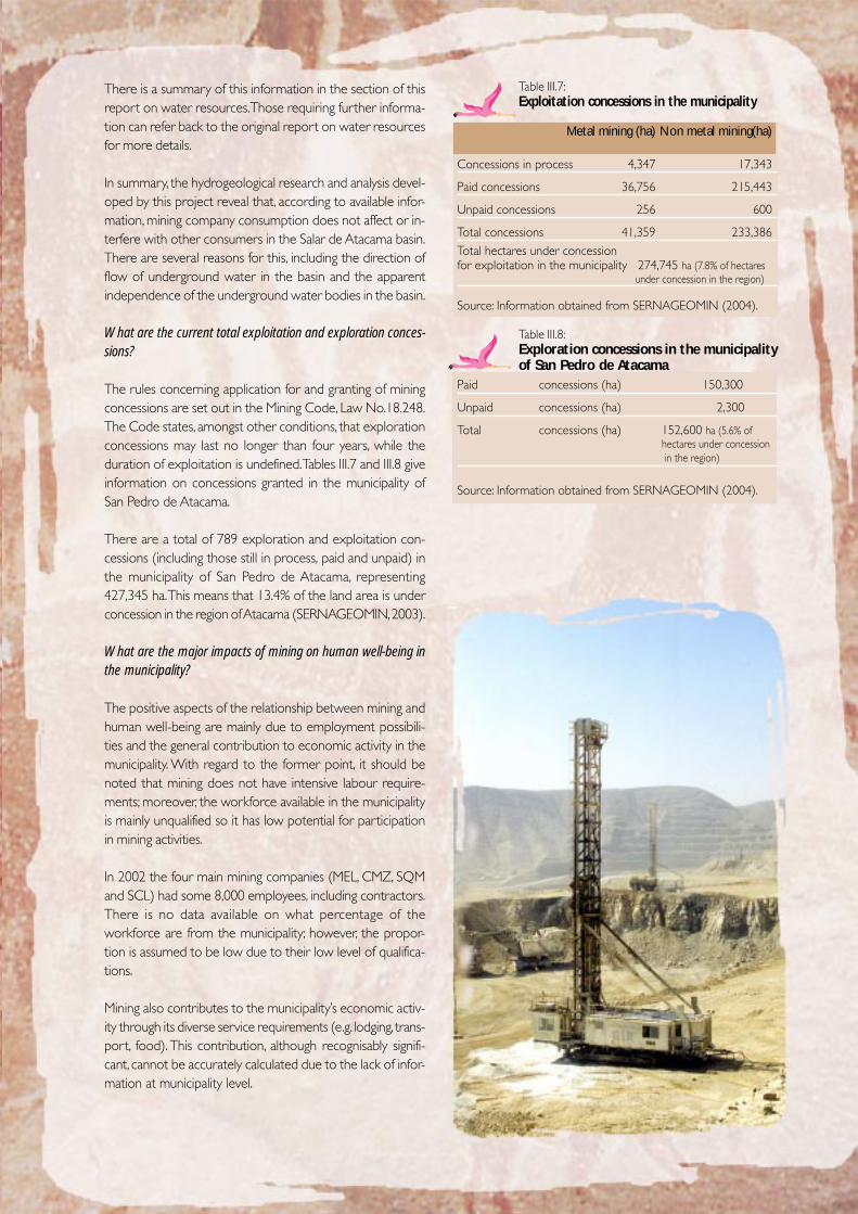
27
There is a summary of this information in the section of thisreport on water resources. Those requiring further informa-tion can refer back to the original report on water resourcesfor more details.
In summary, the hydrogeological research and analysis devel-oped by this project reveal that, according to available infor-mation, mining company consumption does not affect or in-terfere with other consumers in the Salar de Atacama basin.There are several reasons for this, including the direction offlow of underground water in the basin and the apparentindependence of the underground water bodies in the basin.
What are the current total exploitation and exploration conces-sions?
The rules concerning application for and granting of miningconcessions are set out in the Mining Code, Law No.18.248.The Code states, amongst other conditions, that explorationconcessions may last no longer than four years, while theduration of exploitation is undefined. Tables III.7 and III.8 giveinformation on concessions granted in the municipality ofSan Pedro de Atacama.
There are a total of 789 exploration and exploitation con-cessions (including those still in process, paid and unpaid) inthe municipality of San Pedro de Atacama, representing427,345 ha. This means that 13.4% of the land area is underconcession in the region of Atacama (SERNAGEOMIN, 2003).
What are the major impacts of mining on human well-being inthe municipality?
The positive aspects of the relationship between mining andhuman well-being are mainly due to employment possibili-ties and the general contribution to economic activity in themunicipality. With regard to the former point, it should benoted that mining does not have intensive labour require-ments; moreover, the workforce available in the municipalityis mainly unqualified so it has low potential for participationin mining activities.
In 2002 the four main mining companies (MEL, CMZ, SQMand SCL) had some 8,000 employees, including contractors.There is no data available on what percentage of theworkforce are from the municipality; however, the propor-tion is assumed to be low due to their low level of qualifica-tions.
Mining also contributes to the municipality’s economic activ-ity through its diverse service requirements (e.g. lodging, trans-port, food). This contribution, although recognisably signifi-cant, cannot be accurately calculated due to the lack of infor-mation at municipality level.
Table III.7:Exploitation concessions in the municipality
Metal mining (ha) Non metal mining(ha)
Concessions in process 4,347 17,343
Paid concessions 36,756 215,443
Unpaid concessions 256 600
Total concessions 41,359 233,386Total hectares under concessionfor exploitation in the municipality 274,745 ha (7.8% of hectares
under concession in the region)
Source: Information obtained from SERNAGEOMIN (2004).
Table III.8:Exploration concessions in the municipalityof San Pedro de Atacama
Paid concessions (ha) 150,300
Unpaid concessions (ha) 2,300
Total concessions (ha) 152,600 ha (5.6% ofhectares under concession in the region)
Source: Information obtained from SERNAGEOMIN (2004).
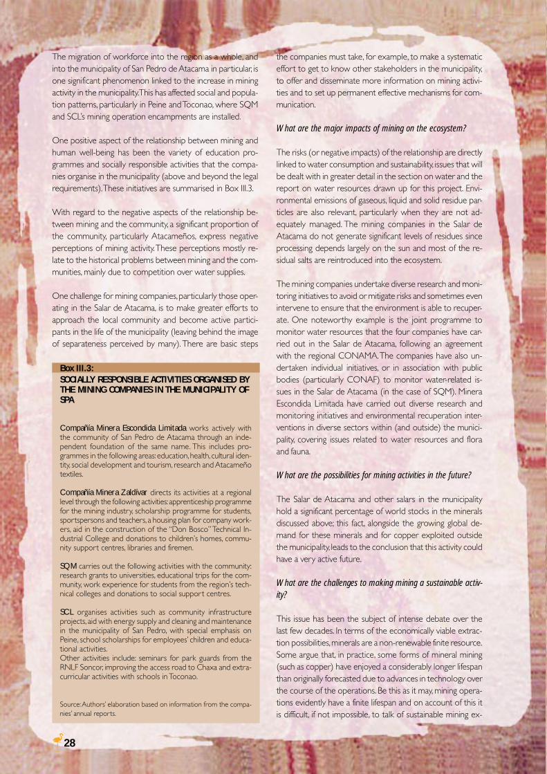
28
The migration of workforce into the region as a whole, andinto the municipality of San Pedro de Atacama in particular, isone significant phenomenon linked to the increase in miningactivity in the municipality. This has affected social and popula-tion patterns, particularly in Peine and Toconao, where SQMand SCL’s mining operation encampments are installed.
One positive aspect of the relationship between mining andhuman well-being has been the variety of education pro-grammes and socially responsible activities that the compa-nies organise in the municipality (above and beyond the legalrequirements). These initiatives are summarised in Box III.3.
With regard to the negative aspects of the relationship be-tween mining and the community, a significant proportion ofthe community, particularly Atacameños, express negativeperceptions of mining activity. These perceptions mostly re-late to the historical problems between mining and the com-munities, mainly due to competition over water supplies.
One challenge for mining companies, particularly those oper-ating in the Salar de Atacama, is to make greater efforts toapproach the local community and become active partici-pants in the life of the municipality (leaving behind the imageof separateness perceived by many). There are basic steps
the companies must take, for example, to make a systematiceffort to get to know other stakeholders in the municipality,to offer and disseminate more information on mining activi-ties and to set up permanent effective mechanisms for com-munication.
What are the major impacts of mining on the ecosystem?
The risks (or negative impacts) of the relationship are directlylinked to water consumption and sustainability, issues that willbe dealt with in greater detail in the section on water and thereport on water resources drawn up for this project. Envi-ronmental emissions of gaseous, liquid and solid residue par-ticles are also relevant, particularly when they are not ad-equately managed. The mining companies in the Salar deAtacama do not generate significant levels of residues sinceprocessing depends largely on the sun and most of the re-sidual salts are reintroduced into the ecosystem.
The mining companies undertake diverse research and moni-toring initiatives to avoid or mitigate risks and sometimes evenintervene to ensure that the environment is able to recuper-ate. One noteworthy example is the joint programme tomonitor water resources that the four companies have car-ried out in the Salar de Atacama, following an agreementwith the regional CONAMA. The companies have also un-dertaken individual initiatives, or in association with publicbodies (particularly CONAF) to monitor water-related is-sues in the Salar de Atacama (in the case of SQM). MineraEscondida Limitada have carried out diverse research andmonitoring initiatives and environmental recuperation inter-ventions in diverse sectors within (and outside) the munici-pality, covering issues related to water resources and floraand fauna.
What are the possibilities for mining activities in the future?
The Salar de Atacama and other salars in the municipalityhold a significant percentage of world stocks in the mineralsdiscussed above; this fact, alongside the growing global de-mand for these minerals and for copper exploited outsidethe municipality, leads to the conclusion that this activity couldhave a very active future.
What are the challenges to making mining a sustainable activ-ity?
This issue has been the subject of intense debate over thelast few decades. In terms of the economically viable extrac-tion possibilities, minerals are a non-renewable finite resource.Some argue that, in practice, some forms of mineral mining(such as copper) have enjoyed a considerably longer lifespanthan originally forecasted due to advances in technology overthe course of the operations. Be this as it may, mining opera-tions evidently have a finite lifespan and on account of this itis difficult, if not impossible, to talk of sustainable mining ex-
Box III.3:SOCIALLY RESPONSIBLE ACTIVITIES ORGANISED BYTHE MINING COMPANIES IN THE MUNICIPALITY OFSPA
Compañía Minera Escondida Limitada works actively withthe community of San Pedro de Atacama through an inde-pendent foundation of the same name. This includes pro-grammes in the following areas: education, health, cultural iden-tity, social development and tourism, research and Atacameñotextiles.
Compañía Minera Zaldívar directs its activities at a regionallevel through the following activities: apprenticeship programmefor the mining industry, scholarship programme for students,sportspersons and teachers, a housing plan for company work-ers, aid in the construction of the “Don Bosco” Technical In-dustrial College and donations to children’s homes, commu-nity support centres, libraries and firemen.
SQM carries out the following activities with the community:research grants to universities, educational trips for the com-munity, work experience for students from the region’s tech-nical colleges and donations to social suppor t centres.
SCL organises activities such as community infrastructureprojects, aid with energy supply and cleaning and maintenancein the municipality of San Pedro, with special emphasis onPeine, school scholarships for employees’ children and educa-tional activities.Other activities include: seminars for park guards from theRNLF Soncor, improving the access road to Chaxa and extra-curricular activities with schools in Toconao.
Source: Authors’ elaboration based on information from the compa-nies’ annual reports.
29
ploitation. However, attempts are underway to generate amore sustainable mining activity, through efforts such as pro-duction clusters and the creation of human and social capital.The objective is for mining exploitation to generate resourcesthat allow the projection of economic activity beyond theuseful lifespan of the mine. All the private and publicstakeholders in the municipality of San Pedro de Atacamashould assume this focus in a coordinated way.
Therefore, the municipality faces diverse challenges, such as:
• To define development priorities: To what degree shouldmining be developed? Is it possible to define some placesthat would remain available for mining and other, protectedareas for example, that would not?
• To ensure planning and management measures, includingpublic-private cooperation mechanisms, that consolidatethe preferred development priorities.
• To find a way for the diverse economic activities in themunicipality to work together harmoniously without af-fecting the capacity of the ecosystems to continue provid-ing goods and services.
“[The project] offered a goodopportunity for all those withconcerns about the Salar deAtacama to express their views onthe opportunities available to usfor improving administration in aclear and transparent way”.Andrés Camaño, Environment Management, MineraEscondida.
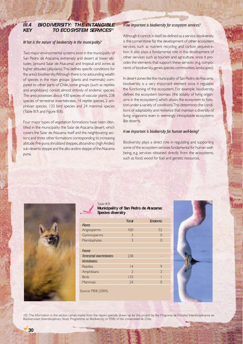
30
III.4 BIODIVERSITY: THE INTANGIBLEKEY TO ECOSYSTEM SERVICES10
What is the nature of biodiversity in the municipality?
Two major environmental systems exist in the municipality ofSan Pedro de Atacama, extremely arid desert at lower alti-tudes (around Salar de Atacama) and tropical arid zones athigher altitudes (altiplano). This defines specific conditions forthe area’s biodiversity. Although there is no astounding wealthof species in the main groups (plants and mammals) com-pared to other parts of Chile, some groups (such as reptilesand amphibians) consist almost entirely of endemic species.The area possesses about 430 species of vascular plants, 238species of terrestrial invertebrates, 14 reptile species, 2 am-phibian species, 133 bird species and 24 mammal species(Table III.9, and Figure III.8).
Four major types of vegetation formations have been iden-tified in the municipality: the Salar de Atacama desert, whichcovers the Salar de Atacama itself and the neighbouring sec-tors; and three other formations corresponding to increasingaltitude: Pre-puna shrubland steppes, altoandino (high Andes)sub-desertic steppe and the alto-andino steppe of the Atacamapuna.
Table III.9:Municipality of San Pedro de Atacama:Species diversity
Total EndemicPlantsAngiosperms 420 52Gymnosperms 3 0Pteridophytes 3 0
FaunaTerrestrial invertebrates 238 -VertebratesReptiles 14 9Amphibians 2 2Birds 133 1Mammals 24 0
Source: PIEB (2004).
10) The information in this section comes mainly from the report specially drawn up for this project by the Programa de Estudios Interdisciplinarios enBiodiversidad (Interdisciplinary Study Programme on Biodiversity or PEIB) of the Universidad de Chile.
How important is biodiversity for ecosystem services?
Although it cannot, in itself, be defined as a service, biodiversityis the cornerstone for the development of other ecosystemservices, such as nutrient recycling and carbon sequestra-tion. It also plays a fundamental role in the development ofother services such as tourism and agriculture, since it pro-vides the elements that support these services (e.g. compo-nents of biodiversity, genes, species, communities, landscapes).
In desert zones like the municipality of San Pedro de Atacama,biodiversity is a very important element since it regulatesthe functioning of the ecosystem. For example, biodiversitydefines the ecosystem biomass (the totality of living organ-isms in the ecosystem), which allows the ecosystem to func-tion under a variety of conditions. This determines the condi-tions of adaptability and resilience that maintain a diversity ofliving organisms even in seemingly inhospitable ecosystemslike deserts.
How important is biodiversity for human well-being?
Biodiversity plays a direct role in regulating and supportingsome of the ecosystem services fundamental for human well-being, e.g. services obtained directly from the ecosystems,such as food, wood for fuel and genetic resources.
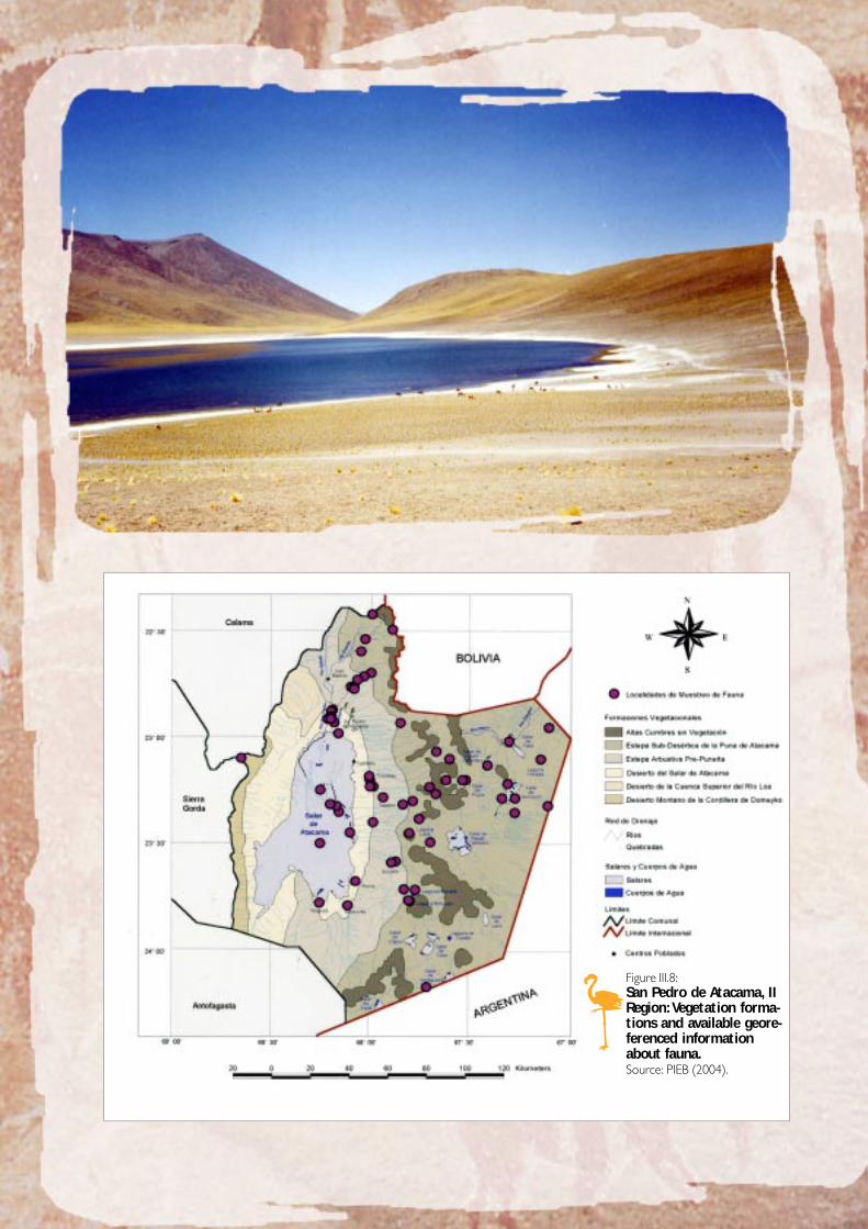
31
Figure III.8:San Pedro de Atacama, IIRegion: Vegetation forma-tions and available geore-ferenced informationabout fauna.Source: PIEB (2004).
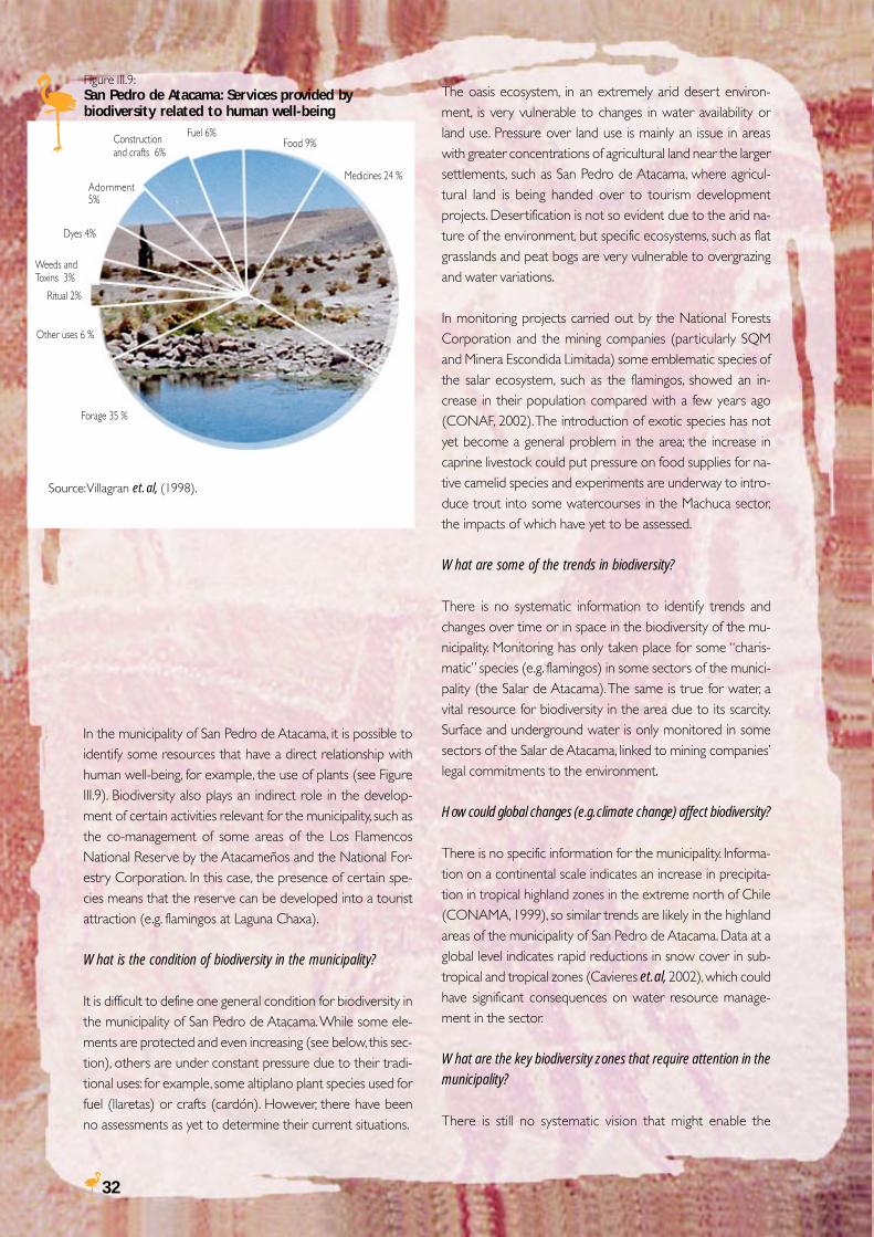
32
In the municipality of San Pedro de Atacama, it is possible toidentify some resources that have a direct relationship withhuman well-being, for example, the use of plants (see FigureIII.9). Biodiversity also plays an indirect role in the develop-ment of certain activities relevant for the municipality, such asthe co-management of some areas of the Los FlamencosNational Reserve by the Atacameños and the National For-estry Corporation. In this case, the presence of certain spe-cies means that the reserve can be developed into a touristattraction (e.g. flamingos at Laguna Chaxa).
What is the condition of biodiversity in the municipality?
It is difficult to define one general condition for biodiversity inthe municipality of San Pedro de Atacama. While some ele-ments are protected and even increasing (see below, this sec-tion), others are under constant pressure due to their tradi-tional uses: for example, some altiplano plant species used forfuel (llaretas) or crafts (cardón). However, there have beenno assessments as yet to determine their current situations.
The oasis ecosystem, in an extremely arid desert environ-ment, is very vulnerable to changes in water availability orland use. Pressure over land use is mainly an issue in areaswith greater concentrations of agricultural land near the largersettlements, such as San Pedro de Atacama, where agricul-tural land is being handed over to tourism developmentprojects. Desertification is not so evident due to the arid na-ture of the environment, but specific ecosystems, such as flatgrasslands and peat bogs are very vulnerable to overgrazingand water variations.
In monitoring projects carried out by the National ForestsCorporation and the mining companies (particularly SQMand Minera Escondida Limitada) some emblematic species ofthe salar ecosystem, such as the flamingos, showed an in-crease in their population compared with a few years ago(CONAF, 2002). The introduction of exotic species has notyet become a general problem in the area; the increase incaprine livestock could put pressure on food supplies for na-tive camelid species and experiments are underway to intro-duce trout into some watercourses in the Machuca sector,the impacts of which have yet to be assessed.
What are some of the trends in biodiversity?
There is no systematic information to identify trends andchanges over time or in space in the biodiversity of the mu-nicipality. Monitoring has only taken place for some “charis-matic” species (e.g. flamingos) in some sectors of the munici-pality (the Salar de Atacama). The same is true for water, avital resource for biodiversity in the area due to its scarcity.Surface and underground water is only monitored in somesectors of the Salar de Atacama, linked to mining companies’legal commitments to the environment.
How could global changes (e.g. climate change) affect biodiversity?
There is no specific information for the municipality. Informa-tion on a continental scale indicates an increase in precipita-tion in tropical highland zones in the extreme north of Chile(CONAMA, 1999), so similar trends are likely in the highlandareas of the municipality of San Pedro de Atacama. Data at aglobal level indicates rapid reductions in snow cover in sub-tropical and tropical zones (Cavieres et. al, 2002), which couldhave significant consequences on water resource manage-ment in the sector.
What are the key biodiversity zones that require attention in themunicipality?
There is still no systematic vision that might enable the
Figure III.9:San Pedro de Atacama: Services provided bybiodiversity related to human well-being
Constructionand crafts 6%
Adornment5%
Fuel 6%Food 9%
Medicines 24 %
Weeds andToxins 3%
Dyes 4%
Ritual 2%
Other uses 6 %
Forage 35 %
Source: Villagran et. al, (1998).
33
prioritisation of relevant sites for biodiversity conservation inthe municipality of San Pedro de Atacama; this has only beenpossible in the north of Chile at a regional scale (IPCC, 2001).These reports identify the northeast of the municipality andthe Laguna Lejía in the altiplano as relevant zones forbiodiversity conservation.
The Salar de Tara has also been included in the RAMSAR listof Wetlands of International Importance. Current environ-mental protection of the Los Flamencos National Reserve inthe municipality of San Pedro de Atacama, gives the opportu-nity for conservation work at sites within the Salar de Atacamaand in some altiplano lakes and salars. The task of drawing up
“[The project] has enabled us to updatedata and, above all, to enhance theinformation available on water re-
sources in the area”.Alejandro Pizarro, Regional Secretary of the Ministry of Agricul-
ture in the II Region.
a systematic plan for biodiversity conservation in the munici-pality –a big step towards improving decision-making on naturalresource management and conservation– is still pending.
What does the future hold for biodiversity in the municipality?
It is impossible to guess an accurate scenario for biodiversityin the municipality without further information on currentbiodiversity conditions and trends. Studies are urgently neededto assess in greater detail the possible effects of climate changein the zone. More base information on the components ofbiodiversity must also be generated in order to determinefuture conditions more accurately.
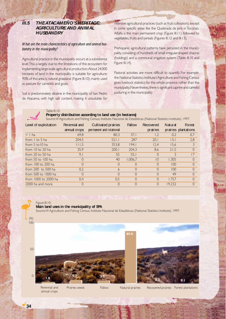
34
Table III.10:Property distribution according to land use (in hectares)Source: VI Agriculture and Fishing Census, Instituto Nacional de Estadísticas (National Statistics Institute), 1997.
III.5 THE ATACAMEÑO’S HERITAGE:AGRICULTURE AND ANIMALHUSBANDRY
What are the main characteristics of agriculture and animal hus-bandry in the municipality?
Agricultural practice in the municipality occurs at a subsistencelevel. This is largely due to the limitations of the ecosystem forimplementing large-scale agricultural production. About 24,000hectares of land in the municipality is suitable for agriculture;90% of this area is natural grassland (Figure III.10), mainly usedas pasture for camelids and goats.
Soil is predominately alkaline in the municipality of San Pedrode Atacama, with high salt content, making it unsuitable for
Figure III.10:Main land uses in the municipality of SPASource: VI Agriculture and Fishing Census, Instituto Nacional de Estadísticas (National Statistics Institute), 1997.
Perennial andannual crops
Prairies seeds Fallow Natural prairies Recovered prairies Forest plantations
100-
50-
0-1.8
5.2 3.70.2 0.1
89.0
intensive agricultural practices (such as fruit cultivation), exceptin some specific areas like the Quebrada de Jere in Toconao.Alfalfa is the main permanent crop (Figure III.11), followed byvegetables, fruits and cereals (Figures III.12 and III.13).
Prehispanic agricultural patterns have persisted in the munici-pality, consisting of hundreds of small irregular-shaped chacras(holdings) and a communal irrigation system (Table III.10 andFigure III.14).
Pastoral activities are more difficult to quantify. For example,the National Statistics Institute’s Agriculture and Fishing Censusgives livestock statistics for the whole province rather than themunicipality. Nevertheless, there is significant caprine and camelidpasturing in the municipality.
Level of exploitation Perennial and Cultivated prairies Fallow Recovered Natural Forest annual crops permanent and rotational prairies prairies plantations
< 1 ha 69,8 80,3 37,1 1,2 0,2 0,7from 1 to 5 ha 204,5 521,1 287 20,1 13,1 2,8from 5 to10 ha 111,5 353,8 194,1 12,4 15,6 3from 10 to 20 ha 35,9 200,1 204,3 8,6 21,5 0from 20 to 50 ha 9,1 55 55,1 0 3 17from 50 to 100 ha 0 40 1.006,7 10 1.305 0from 100 to 200 ha 0 0 0 0 100 0from 200 to 500 ha 0,2 6 0 0 100 0from 500 to 1000 ha 0 0 0 0 49 0from 1000 to 2000 ha 0,4 0,5 0 0 1.757 02000 ha and more 0 0 0 0 19.232 0
(%)
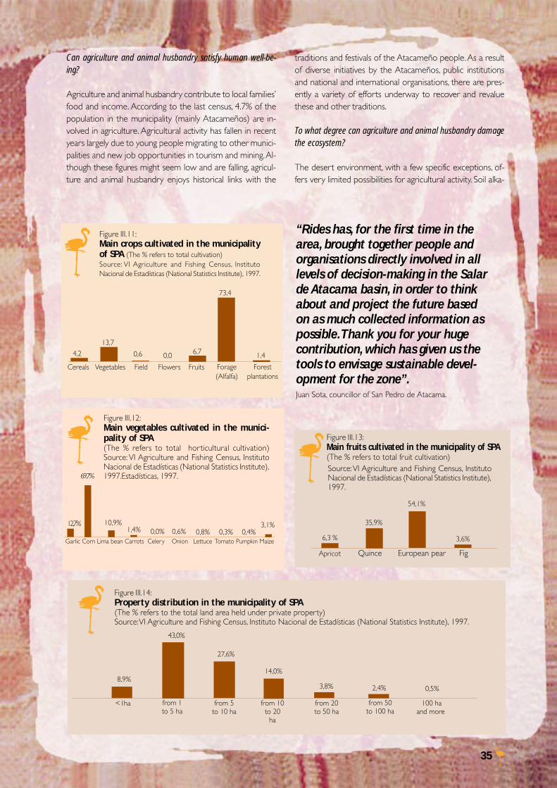
35
Figure III.14:Property distribution in the municipality of SPA(The % refers to the total land area held under private property)Source: VI Agriculture and Fishing Census, Instituto Nacional de Estadísticas (National Statistics Institute), 1997.
<1ha from 5to 10 ha
from 1to 5 ha
from 10to 20
ha
from 20to 50 ha
from 50to 100 ha
8,9%
43,0%
27,6%
14,0%
3,8% 2,4%
100 haand more
0,5%
Figure III.11:Main crops cultivated in the municipalityof SPA (The % refers to total cultivation)Source: VI Agriculture and Fishing Census, InstitutoNacional de Estadísticas (National Statistics Institute), 1997.
Figure III.12:Main vegetables cultivated in the munici-pality of SPA(The % refers to total horticultural cultivation)Source: VI Agriculture and Fishing Census, InstitutoNacional de Estadísticas (National Statistics Institute),1997.Estadísticas, 1997.
Garlic Corn Lima bean Carrots Celery Onion Lettuce Tomato Pumpkin Maize
12,7%
69,7%
1,4%10,9%
0,0%3,1%
0,6% 0,8% 0,3% 0,4%
Cereals FieldVegetables Flowers Fruits Forage(Alfalfa)
4,2
13,76,7 1,4
Figure III.13:Main fruits cultivated in the municipality of SPA
Source: VI Agriculture and Fishing Census, InstitutoNacional de Estadísticas (National Statistics Institute),1997.
“Rides has, for the first time in thearea, brought together people andorganisations directly involved in alllevels of decision-making in the Salarde Atacama basin, in order to thinkabout and project the future basedon as much collected information aspossible. Thank you for your hugecontribution, which has given us thetools to envisage sustainable devel-opment for the zone”.Juan Sota, councillor of San Pedro de Atacama.
Can agriculture and animal husbandry satisfy human well-be-ing?
Agriculture and animal husbandry contribute to local families’food and income. According to the last census, 4.7% of thepopulation in the municipality (mainly Atacameños) are in-volved in agriculture. Agricultural activity has fallen in recentyears largely due to young people migrating to other munici-palities and new job opportunities in tourism and mining. Al-though these figures might seem low and are falling, agricul-ture and animal husbandry enjoys historical links with the
Forestplantations
73,4
0,6 0,0
traditions and festivals of the Atacameño people. As a resultof diverse initiatives by the Atacameños, public institutionsand national and international organisations, there are pres-ently a variety of efforts underway to recover and revaluethese and other traditions.
To what degree can agriculture and animal husbandry damagethe ecosystem?
The desert environment, with a few specific exceptions, of-fers very limited possibilities for agricultural activity. Soil alka-
(The % refers to total fruit cultivation)
Apricot Quince European pear Fig
6,3 %
35,9%
54,1%
3,6%
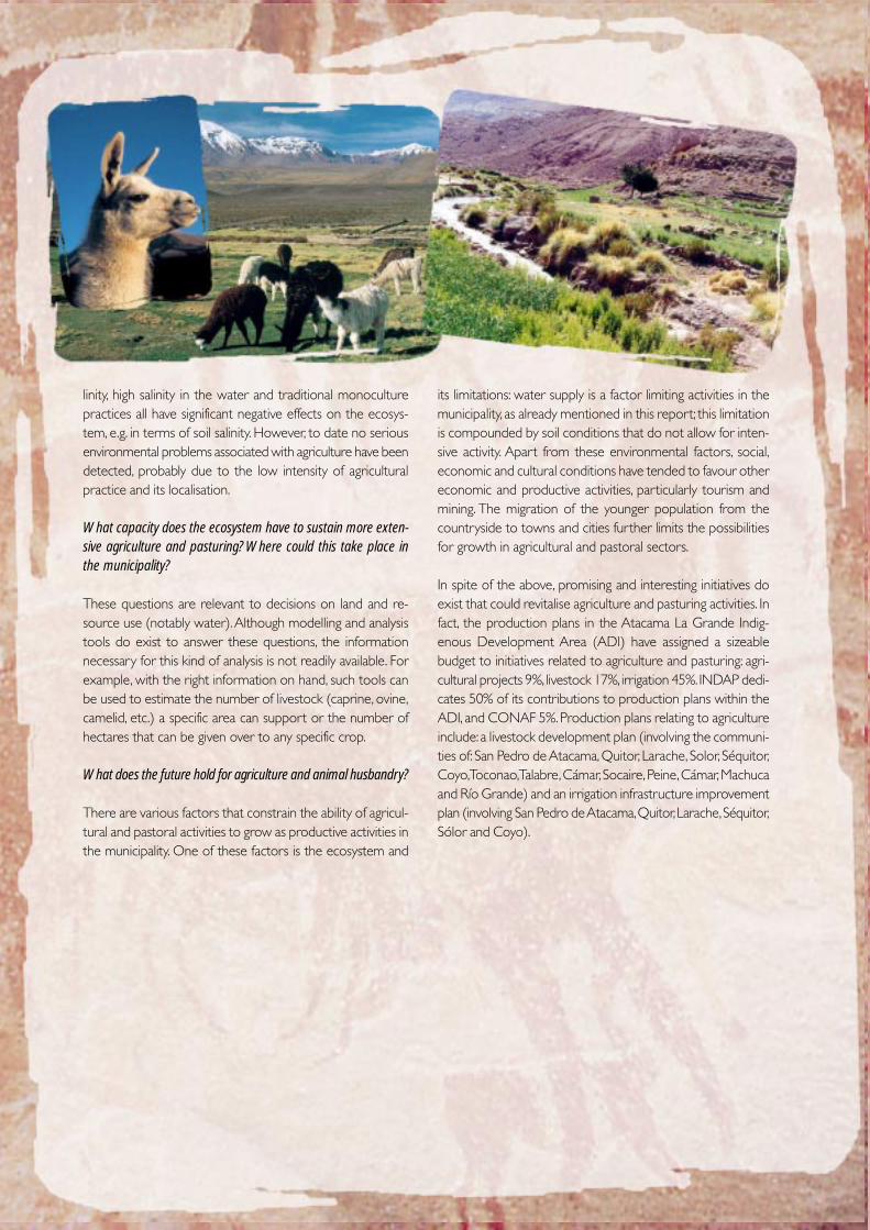
36
linity, high salinity in the water and traditional monoculturepractices all have significant negative effects on the ecosys-tem, e.g. in terms of soil salinity. However, to date no seriousenvironmental problems associated with agriculture have beendetected, probably due to the low intensity of agriculturalpractice and its localisation.
What capacity does the ecosystem have to sustain more exten-sive agriculture and pasturing? Where could this take place inthe municipality?
These questions are relevant to decisions on land and re-source use (notably water). Although modelling and analysistools do exist to answer these questions, the informationnecessary for this kind of analysis is not readily available. Forexample, with the right information on hand, such tools canbe used to estimate the number of livestock (caprine, ovine,camelid, etc.) a specific area can support or the number ofhectares that can be given over to any specific crop.
What does the future hold for agriculture and animal husbandry?
There are various factors that constrain the ability of agricul-tural and pastoral activities to grow as productive activities inthe municipality. One of these factors is the ecosystem and
its limitations: water supply is a factor limiting activities in themunicipality, as already mentioned in this report; this limitationis compounded by soil conditions that do not allow for inten-sive activity. Apart from these environmental factors, social,economic and cultural conditions have tended to favour othereconomic and productive activities, particularly tourism andmining. The migration of the younger population from thecountryside to towns and cities further limits the possibilitiesfor growth in agricultural and pastoral sectors.
In spite of the above, promising and interesting initiatives doexist that could revitalise agriculture and pasturing activities. Infact, the production plans in the Atacama La Grande Indig-enous Development Area (ADI) have assigned a sizeablebudget to initiatives related to agriculture and pasturing: agri-cultural projects 9%, livestock 17%, irrigation 45%. INDAP dedi-cates 50% of its contributions to production plans within theADI, and CONAF 5%. Production plans relating to agricultureinclude: a livestock development plan (involving the communi-ties of: San Pedro de Atacama, Quitor, Larache, Solor, Séquitor,Coyo, Toconao, Talabre, Cámar, Socaire, Peine, Cámar, Machucaand Río Grande) and an irrigation infrastructure improvementplan (involving San Pedro de Atacama, Quitor, Larache, Séquitor,Sólor and Coyo).
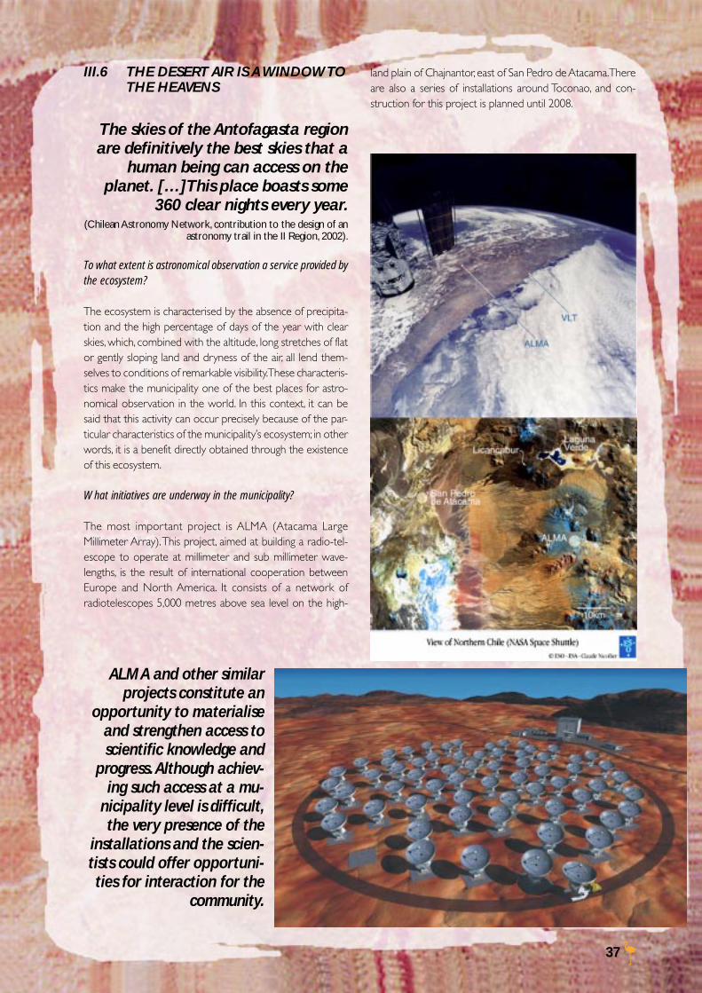
37
III.6 THE DESERT AIR IS A WINDOW TOTHE HEAVENS
The skies of the Antofagasta regionare definitively the best skies that a
human being can access on theplanet. […]This place boasts some
360 clear nights every year.(Chilean Astronomy Network, contribution to the design of an
astronomy trail in the II Region, 2002).
To what extent is astronomical observation a service provided bythe ecosystem?
The ecosystem is characterised by the absence of precipita-tion and the high percentage of days of the year with clearskies, which, combined with the altitude, long stretches of flator gently sloping land and dryness of the air, all lend them-selves to conditions of remarkable visibility. These characteris-tics make the municipality one of the best places for astro-nomical observation in the world. In this context, it can besaid that this activity can occur precisely because of the par-ticular characteristics of the municipality’s ecosystem; in otherwords, it is a benefit directly obtained through the existenceof this ecosystem.
What initiatives are underway in the municipality?
The most important project is ALMA (Atacama LargeMillimeter Array). This project, aimed at building a radio-tel-escope to operate at millimeter and sub millimeter wave-lengths, is the result of international cooperation betweenEurope and North America. It consists of a network ofradiotelescopes 5,000 metres above sea level on the high-
ALMA and other similarprojects constitute an
opportunity to materialiseand strengthen access toscientific knowledge and
progress. Although achiev-ing such access at a mu-
nicipality level is difficult,the very presence of the
installations and the scien-tists could offer opportuni-ties for interaction for the
community.
land plain of Chajnantor, east of San Pedro de Atacama. Thereare also a series of installations around Toconao, and con-struction for this project is planned until 2008.
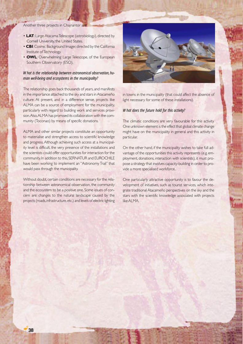
38
Another three projects in Chajnantor are:
• LAT: Large Atacama Telescope (astrobiology), directed byCornell University, the United States.
• CBI: Cosmic Background Imager, directed by the CaliforniaInstitute of Technology.
• OWL: Overwhelming Large Telescope, of the EuropeanSouthern Observatory (ESO).
What is the relationship between astronomical observation, hu-man well-being and ecosystems in the municipality?
The relationship goes back thousands of years, and manifestsin the importance attached to the sky and stars in Atacameñoculture. At present, and in a difference sense, projects likeALMA can be a source of employment for the municipality,particularly with regard to building work and services provi-sion. Also, ALMA has promised its collaboration with the com-munity (Toconao) by means of specific donations.
ALMA and other similar projects constitute an opportunityto materialise and strengthen access to scientific knowledgeand progress. Although achieving such access at a municipal-ity level is difficult, the very presence of the installations andthe scientists could offer opportunities for interaction for thecommunity. In addition to this, SERNATUR and EUROCHILEhave been working to implement an “Astronomy Trail” thatwould pass through the municipality.
Without doubt, certain conditions are necessary for the rela-tionship between astronomical observation, the communityand the ecosystem to be a positive one. Some issues of con-cern are: changes to the natural landscape caused by theprojects (roads, infrastructure, etc.) and levels of electric lighting
in towns in the municipality (that could affect the absence oflight necessary for some of these installations).
What does the future hold for this activity?
The climatic conditions are very favourable for this activity.One unknown element is the effect that global climate changemight have on the municipality in general and this activity inparticular.
On the other hand, if the municipality wishes to take full ad-vantage of the opportunities this activity represents (e.g. em-ployment, donations, interaction with scientists), it must pro-pose a strategy that involves capacity-building in order to pro-vide a more specialised workforce.
One particularly attractive opportunity is to favour the de-velopment of initiatives, such as tourist services, which inte-grate traditional Atacameño perspectives on the sky and thestars with the scientific knowledge associated with projectslike ALMA.
39
THE ATACAMEÑO CULTURE IS PART AND PARCEL OF THE ALTIPLANO ECOSYSTEM
Ever since their very beginnings, the Atacameño people of the Andes have had common traditions and a shared world view. Thisworld view is based on a holistic and integrated understanding of the relationships between human beings and the land or Patta Hoiri(mother earth), a concept embracing the guardian hills, the water – generator of life, the soil, the ancestors and the heavens.
Even though this complex and interesting system of knowledge was not systematically incorporated into this project*, we haveidentified three relevant types of knowledge of the ecosystem:
• Ecological knowledge - “what is happening in the ecosystems”: involves knowledge of flora and fauna and diversity, as well asecological dynamics (processes and functions) across different interrelated spatial and temporal scales.
• Technology and knowledge of management practices: ancestral techniques to maintain or increase the ecosystems’ capacity toprovide services.
• Symbolic knowledge: knowledge of religious rituals and functions in the landscape and nature. This also refers to the value andimportance of nature in the Atacameño culture.
The following box presents a description of each type of traditional knowledge (ecological knowledge, technology and knowledge,symbolic knowledge) in terms of its source (those who hold the knowledge), contents, distribution, means of transmission and itsrelationship to ecosystem services.
Box III.4:
Traditional knowledge in SPA
Source Types Contents Distribution Transmission Ecosystem services
Elders 1-2-3 Uses, practices and Very small number Oral Support and culturalmeaning of nature of elders in the in the traditional smaller lifestyle.
settlements.
Shepherds 1-2 Plants to feed livestock, Very small number Families and individuals. Support andtheir distribution and of shepherds in the Oral and through regulationlife cycle. Location and smaller settlements. practice.quantity of water sources.Herding landscapeand routes.Fauna characteristics
Farmers 1-2 Irrigation systems and A significant number Families and individuals. Supportcultivation techniques. in each settlement. Oral and throughFlora characteristics. observation.
Healers 1-3 Names, uses and A small number Selective, Oral, through Support and culturalimportance of medicinal of individuals. practice andplants, geographical observation.distribution and ritualsassociated with their use.
Individuals 3 Importance of landscape, Young people and Oral and Culturalmyths and traditions adults interested in through practice.(rituals, dances, festivals) preserving and
continuing thetraditional lifestyle.
Anthropologists 1-2-3 Recollection of past and Team of researchers. Documents, seminars Cultural(museum) present uses and the “state of and courses
the art” in different aspects (for the Atacameños)of traditional knowledge.
Source: Authors’ elaboration.
*The knowledge and interests of the Atacameño people were incorporated through the presence of representatives in the advisorycommittee, a special meeting for Atacameño leaders and a series of complementary activities (trip for Atacameño children to the LosFlamencos National reserve and a video documenting meetings about traditions between the elders and the children).
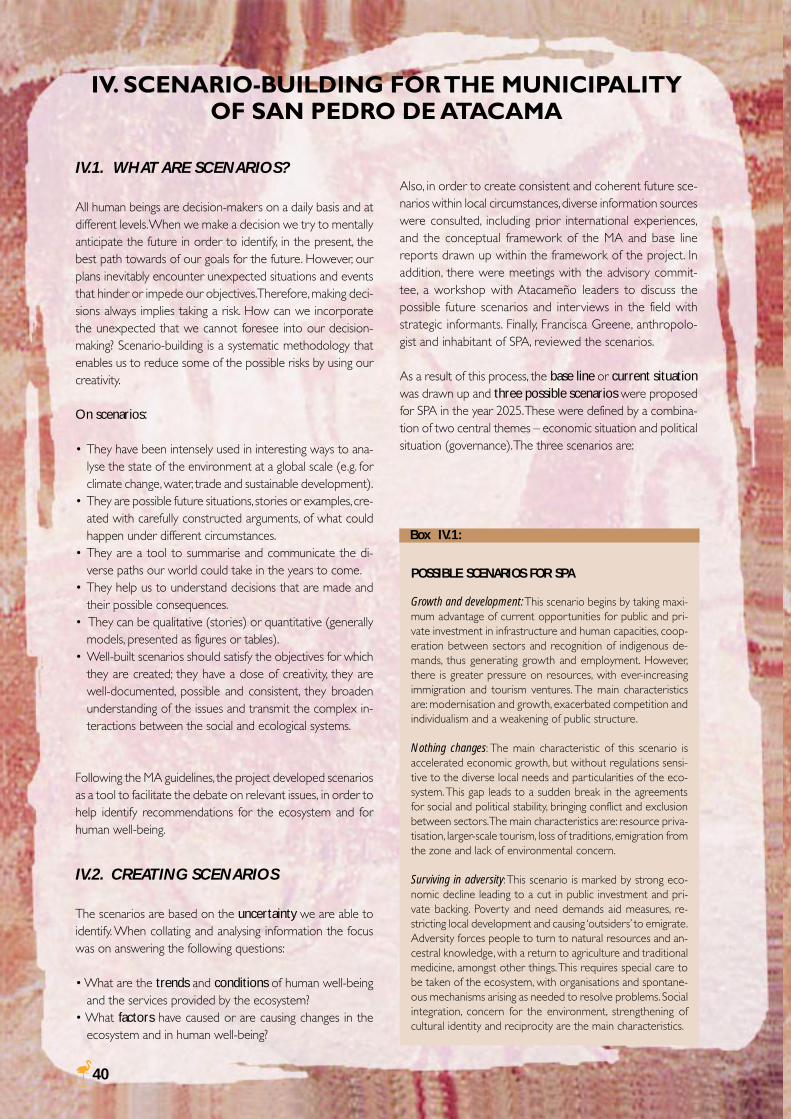
40
Also, in order to create consistent and coherent future sce-narios within local circumstances, diverse information sourceswere consulted, including prior international experiences,and the conceptual framework of the MA and base linereports drawn up within the framework of the project. Inaddition, there were meetings with the advisory commit-tee, a workshop with Atacameño leaders to discuss thepossible future scenarios and interviews in the field withstrategic informants. Finally, Francisca Greene, anthropolo-gist and inhabitant of SPA, reviewed the scenarios.
As a result of this process, the base line or current situationwas drawn up and three possible scenarios were proposedfor SPA in the year 2025. These were defined by a combina-tion of two central themes – economic situation and politicalsituation (governance). The three scenarios are:
IV. SCENARIO-BUILDING FOR THE MUNICIPALITYOF SAN PEDRO DE ATACAMA
IV.1. WHAT ARE SCENARIOS?
All human beings are decision-makers on a daily basis and atdifferent levels. When we make a decision we try to mentallyanticipate the future in order to identify, in the present, thebest path towards of our goals for the future. However, ourplans inevitably encounter unexpected situations and eventsthat hinder or impede our objectives. Therefore, making deci-sions always implies taking a risk. How can we incorporatethe unexpected that we cannot foresee into our decision-making? Scenario-building is a systematic methodology thatenables us to reduce some of the possible risks by using ourcreativity.
On scenarios:
• They have been intensely used in interesting ways to ana-lyse the state of the environment at a global scale (e.g. forclimate change, water, trade and sustainable development).
• They are possible future situations, stories or examples, cre-ated with carefully constructed arguments, of what couldhappen under different circumstances.
• They are a tool to summarise and communicate the di-verse paths our world could take in the years to come.
• They help us to understand decisions that are made andtheir possible consequences.
• They can be qualitative (stories) or quantitative (generallymodels, presented as figures or tables).
• Well-built scenarios should satisfy the objectives for whichthey are created; they have a dose of creativity, they arewell-documented, possible and consistent, they broadenunderstanding of the issues and transmit the complex in-teractions between the social and ecological systems.
Following the MA guidelines, the project developed scenariosas a tool to facilitate the debate on relevant issues, in order tohelp identify recommendations for the ecosystem and forhuman well-being.
IV.2. CREATING SCENARIOS
The scenarios are based on the uncertainty we are able toidentify. When collating and analysing information the focuswas on answering the following questions:
• What are the trends and conditions of human well-beingand the services provided by the ecosystem?
• What factors have caused or are causing changes in theecosystem and in human well-being?
POSSIBLE SCENARIOS FOR SPA
Growth and development: This scenario begins by taking maxi-mum advantage of current opportunities for public and pri-vate investment in infrastructure and human capacities, coop-eration between sectors and recognition of indigenous de-mands, thus generating growth and employment. However,there is greater pressure on resources, with ever-increasingimmigration and tourism ventures. The main characteristicsare: modernisation and growth, exacerbated competition andindividualism and a weakening of public structure.
Nothing changes: The main characteristic of this scenario isaccelerated economic growth, but without regulations sensi-tive to the diverse local needs and particularities of the eco-system. This gap leads to a sudden break in the agreementsfor social and political stability, bringing conflict and exclusionbetween sectors. The main characteristics are: resource priva-tisation, larger-scale tourism, loss of traditions, emigration fromthe zone and lack of environmental concern.
Surviving in adversity: This scenario is marked by strong eco-nomic decline leading to a cut in public investment and pri-vate backing. Poverty and need demands aid measures, re-stricting local development and causing ‘outsiders’ to emigrate.Adversity forces people to turn to natural resources and an-cestral knowledge, with a return to agriculture and traditionalmedicine, amongst other things. This requires special care tobe taken of the ecosystem, with organisations and spontane-ous mechanisms arising as needed to resolve problems. Socialintegration, concern for the environment, strengthening ofcultural identity and reciprocity are the main characteristics.
Box IV.1:
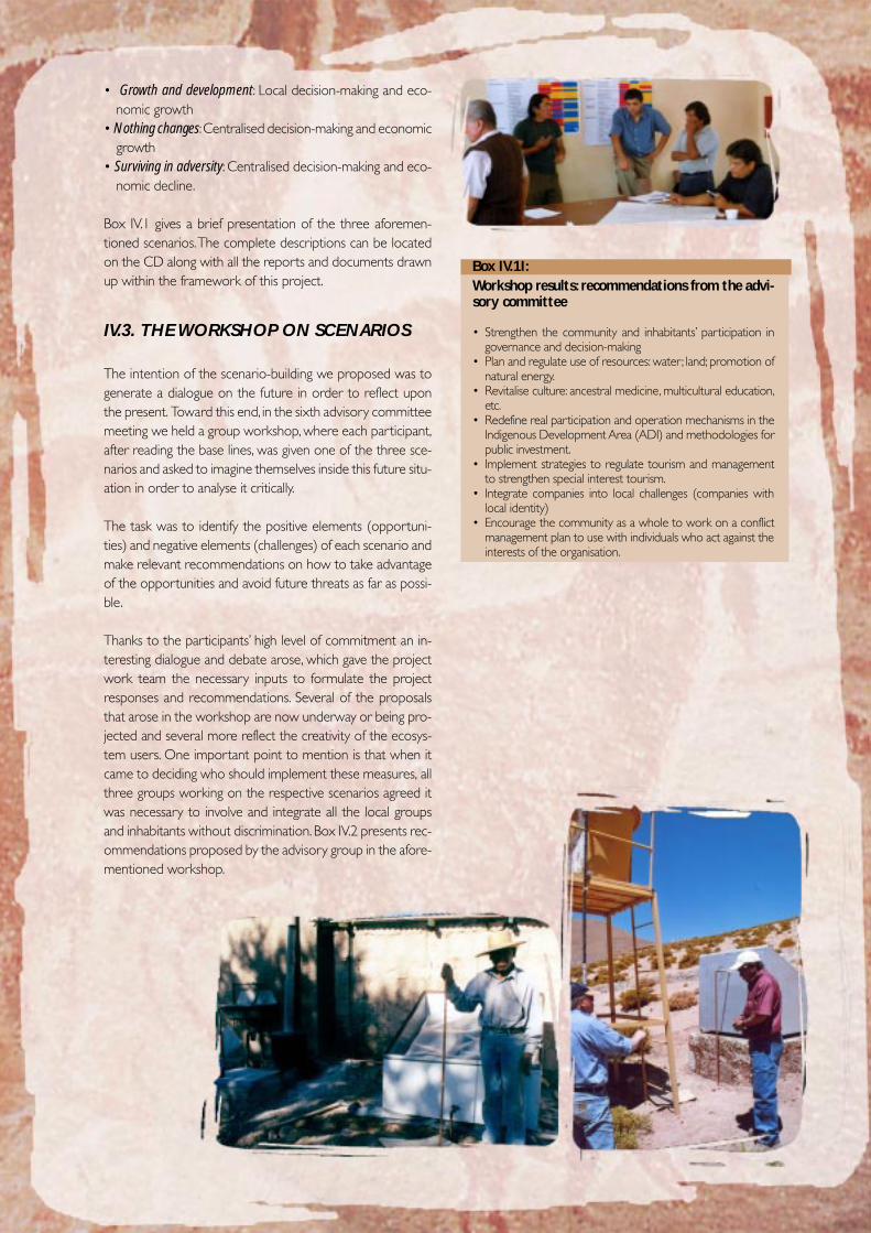
41
Workshop results: recommendations from the advi-sory committee
• Strengthen the community and inhabitants’ participation ingovernance and decision-making
• Plan and regulate use of resources: water; land; promotion ofnatural energy.
• Revitalise culture: ancestral medicine, multicultural education,etc.
• Redefine real participation and operation mechanisms in theIndigenous Development Area (ADI) and methodologies forpublic investment.
• Implement strategies to regulate tourism and managementto strengthen special interest tourism.
• Integrate companies into local challenges (companies withlocal identity)
• Encourage the community as a whole to work on a conflictmanagement plan to use with individuals who act against theinterests of the organisation.
• Growth and development: Local decision-making and eco-nomic growth
• Nothing changes: Centralised decision-making and economicgrowth
• Surviving in adversity: Centralised decision-making and eco-nomic decline.
Box IV.1 gives a brief presentation of the three aforemen-tioned scenarios. The complete descriptions can be locatedon the CD along with all the reports and documents drawnup within the framework of this project.
IV.3. THE WORKSHOP ON SCENARIOS
The intention of the scenario-building we proposed was togenerate a dialogue on the future in order to reflect uponthe present. Toward this end, in the sixth advisory committeemeeting we held a group workshop, where each participant,after reading the base lines, was given one of the three sce-narios and asked to imagine themselves inside this future situ-ation in order to analyse it critically.
The task was to identify the positive elements (opportuni-ties) and negative elements (challenges) of each scenario andmake relevant recommendations on how to take advantageof the opportunities and avoid future threats as far as possi-ble.
Thanks to the participants’ high level of commitment an in-teresting dialogue and debate arose, which gave the projectwork team the necessary inputs to formulate the projectresponses and recommendations. Several of the proposalsthat arose in the workshop are now underway or being pro-jected and several more reflect the creativity of the ecosys-tem users. One important point to mention is that when itcame to deciding who should implement these measures, allthree groups working on the respective scenarios agreed itwas necessary to involve and integrate all the local groupsand inhabitants without discrimination. Box IV.2 presents rec-ommendations proposed by the advisory group in the afore-mentioned workshop.
Box IV.1I:
42
Responses are seen as recommendations, made by the workteam and the advisory committee, to enable the differentecosystem users and decision-makers to tackle the challengesfacing the sustainable management of ecosystems and hu-man well-being in SPA.
This product is the result of the research and participationprocess, and as such it integrates the information obtainedfrom diverse sources, including:
• Base lines on ecosystem services and human well-beingdrawn up for this project.
• Scenario development and workshop held with the advi-sory committee.
• Preliminary MA reports.• Sustainability criteria defined by the project work team (Box
V.1).• Interaction between the work team and institutions and
individuals of SPA.
A series of proposals were thus drawn up that were dis-cussed and added to in the final advisory committee meetingand are presented below. The tables give a general descrip-tion of the recommendations, each group’s objective, possi-ble executors of the measures, time period or scale and geo-graphical reach or scale implied.
The recommendations are grouped into two main intercon-nected issues. Those recommendations relating directly tosocial or administrative issues are listed first, followed by thosereferring to specific ecosystem services. The final section in-cludes recommendations arising from the lessons learnt bythe project team over the course of the project, which couldbe helpful for similar experiences in Chile or the rest of theworld in the future.
V. RESPONSES FOR SUSTAINABLE MANAGE-MENT AND HUMAN WELL-BEING
CRITERIA FOR SUSTAINABILITY RECOMMENDATIONS
1) Integrate values of ecosystem services into the deci-sions
2) Belonging and cultural diversity (non-discrimination)
3) Coordination, organisation, collaboration, participation,conflict resolution
4) Integrated/holistic focus (coordination between actions,long-term view)
5) Precautionary principle in decision-making, always lookat alternatives
6) Education and knowledge dissemination
7) Equality between all the sectors
8) Deal with uncertainty
9) Encourage initiatives for sustainable markets and con-solidate (individual and collective) property rights
Box V.1:
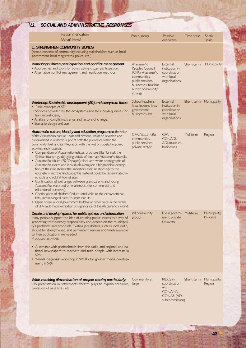
43
V.1. SOCIAL AND ADMINISTRATIVE RESPONSES
RecommendationWhat? How?
Focus group Possible Time scale Spatial executors scale
AtacameñoPeoples Council(CPA), Atacameñocommunities,public services,businesses, tourismsector, communityat large.
School teachers,local leaders, localgovernment,businesses, etc.
CPA, Atacameñocommunities,public services,private sector
All communitygroups
Community atlarge
Externalinstitution incoordinationwith localorganisations
Externalinstitution incoordinationwith localorganisations
CPA,CONADI,ADI, museum,businesses
Local govern-ment, privateinitiatives
RIDES incoordinationwithCONAMA,CONAF (ADIsubcommission)
Municipality
Municipality
Region
Municipality,Province
Municipality,Region
Short-term
Short-term
Mid-term
Mid-term
Short-term
1. STRENGTHEN COMMUNITY BONDS(broad concept of community, including stakeholders such as localgovernment, local magistrates, police, etc.)
Workshop: Citizen participation and conflict management• Approaches and tools for constructive citizen participation.• Alternative conflict management and resolution methods.
Workshop: Sustainable development (SD) and ecosystem focus• Basic concepts of SD.• Services provided by the ecosystems and their consequences for
human well-being.• Analysis of conditions, trends and factors of change.• Scenario design and use.
Atacameño culture, identity and education programme: the valueof the Atacameño culture –past and present– must be revealed anddisseminated in order to support both the processes within thecommunity itself and its integration with the rest of society. Proposedactivities and materials:• Compendium of Atacameño festivals: brochure (like ‘Turistel’, the
Chilean tourism guide) giving details of the main Atacameño festivals.• Atacameño album (20-30 pages): black and white photographs of
Atacameño elders and individuals, alongside a biographical descrip-tion of their life stories; the ancestors, their relationship to theecosystem and the landscape; this material could be disseminated inschools and sold at tourist sites.
• Continuation of exchanges between grandparents and youngAtacameños recorded on multimedia (for commercial andeducational purposes).
• Continuation of children’s’ educational visits to the ecosystem: saltflats, archaeological ruins, tourism circuits.
• Open house in local government building or other place in the centreof SPA: multimedia exhibition on significance of the Atacameño´s world.
Create and develop ‘spaces’ for public opinion and information:Many people support the idea of creating public spaces as a way ofgenerating transparency, responsibility and debate on the municipali-ty’s problems and proposals. Existing possibilities, such as local radio,should be strengthened, and permanent, serious and freely availablewritten publications are needed.Proposed activities:
• A seminar with professionals from the radio and regional and na-tional newspapers to motivate and train people with interests inSPA.
• ‘Needs diagnosis’ workshop (SWOT) for greater media develop-ment in SPA.
Wide-reaching dissemination of project results; particularly:GIS presentation in settlements, theatre plays to explain scenarios,validation of base lines, etc.
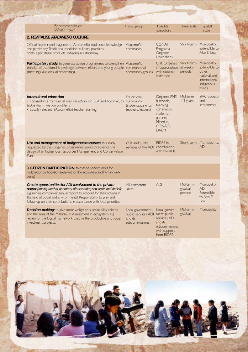
44
CONAFProgramaOrígenesUniversities
CPA, Orígenes,in coordinationwith externalinstitution
Orígenes, FME,8 schools,teachingcommunity,students,parents.Mineduc,CONADI,DAEM
RIDES incoordinationwith the ADI
ADI
Local govern-ment, publicservices, ADIand itssubcommissions,with supportfrom RIDES
Municipality,extendible toAlto El Loa
Municipality,extendible toothernational andinternationalindigenouszones
SPA, Toconaoandsettlements
Municipality,ADI
Municipality,ADIExtendibleto Alto ElLoa
Municipality
Short-term
Short-termat weeklyperiods
Mid-term1-3 years
Short-term
Mid-term,gradualprocess
Mid-term,gradual
2. REVITALISE ATACAMEÑO CULTURE
Official register and diagnosis of Atacameño traditional knowledgeand patrimony: Traditional medicine, culinary practices,crafts, agricultural products, indigenous astronomy.
Participatory study: to generate action programmes to strengthentransfer of traditional knowledge between elders and young people(meetings, audiovisual recordings).
Intercultural education• Focused in a transversal way on schools in SPA and Toconao, totackle discrimination problems.• Locally relevant (Atacameño) teacher training.
Use and management of indigenous resources: this study,requested by the Orígenes programme, seeks to advance thedesign of an Indigenous Resources Management and ConservationPlan.
3. CITIZEN PARTICIPATION: to extend opportunities formultisector participation (relevant for the ecosystem and human well-being)
Create opportunities for ADI involvement in the privatesector (mining, tourism operators, observatories; new rights and duties):e.g. mining companies’ annual report to account for their actions inthe field of Social and Environmental Responsibility, to plan andfollow up on their contributions in accordance with local priorities.
Decision-making: to give more weight to sustainability criteriaand the aims of the Millennium Assessment in ecosystem: e.g.review of the logical framework used in the productive and socialinvestment projects.
Atacameñocommunity
Atacameñocommunity, allcommunity groups
Educationalcommunity(students, parents,teachers, leaders)
CPA and publicservices of the ADI
All ecosystemusers
Local government,public services, ADIand itssubcommissions
RecommendationWhat? How?
Focus group Possible Time scale Spatial executors scale
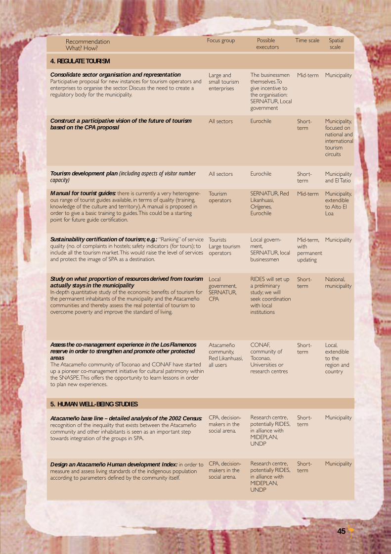
45
4. REGULATE TOURISM
Consolidate sector organisation and representationParticipative proposal for new instances for tourism operators andenterprises to organise the sector. Discuss the need to create aregulatory body for the municipality.
Construct a participative vision of the future of tourismbased on the CPA proposal
Tourism development plan (including aspects of visitor numbercapacity)
Manual for tourist guides: there is currently a very heterogene-ous range of tourist guides available, in terms of quality (training,knowledge of the culture and territory). A manual is proposed inorder to give a basic training to guides. This could be a startingpoint for future guide certification.
Sustainability certification of tourism; e.g.: “Ranking” of servicequality (no. of complaints in hostels; safety indicators (for tours); toinclude all the tourism market. This would raise the level of servicesand protect the image of SPA as a destination.
Study on what proportion of resources derived from tourismactually stays in the municipalityIn-depth quantitative study of the economic benefits of tourism forthe permanent inhabitants of the municipality and the Atacameñocommunities and thereby assess the real potential of tourism toovercome poverty and improve the standard of living.
Assess the co-management experience in the Los Flamencosreserve in order to strengthen and promote other protectedareasThe Atacameño community of Toconao and CONAF have startedup a pioneer co-management initiative for cultural patrimony withinthe SNASPE. This offers the opportunity to learn lessons in orderto plan new experiences.
5. HUMAN WELL-BEING STUDIES
Atacameño base line – detailed analysis of the 2002 Census:recognition of the inequality that exists between the Atacameñocommunity and other inhabitants is seen as an important steptowards integration of the groups in SPA.
Design an Atacameño Human development Index: in order tomeasure and assess living standards of the indigenous populationaccording to parameters defined by the community itself.
RecommendationWhat? How?
Focus group Possible Time scale Spatial executors scale
Large andsmall tourismenterprises
All sectors
All sectors
Tourismoperators
TouristsLarge tourismoperators
Localgovernment,SERNATUR,CPA
Atacameñocommunity,Red Likanhuasi,all users
CPA, decision-makers in thesocial arena.
CPA, decision-makers in thesocial arena.
The businessmenthemselves.Togive incentive tothe organisation:SERNATUR, Localgovernment
Eurochile
Eurochile
SERNATUR, RedLikanhuasi,Orígenes,Eurochile
Local govern-ment,SERNATUR, localbusinessmen
RIDES will set upa preliminarystudy; we willseek coordinationwith localinstitutions
CONAF,community ofToconao,Universities orresearch centres
Research centre,potentially RIDES,in alliance withMIDEPLAN,UNDP
Research centre,potentially RIDES,in alliance withMIDEPLAN,UNDP
Mid-term
Short-term
Short-term
Mid-term
Mid-term,withpermanentupdating
Short-term
Short-term
Short-term
Short-term
Municipality
Municipality,focused onnational andinternationaltourismcircuits
Municipalityand El Tatio
Municipality,extendibleto Alto ElLoa
Municipality
National,municipality
Local,extendibleto theregion andcountry
Municipality
Municipality
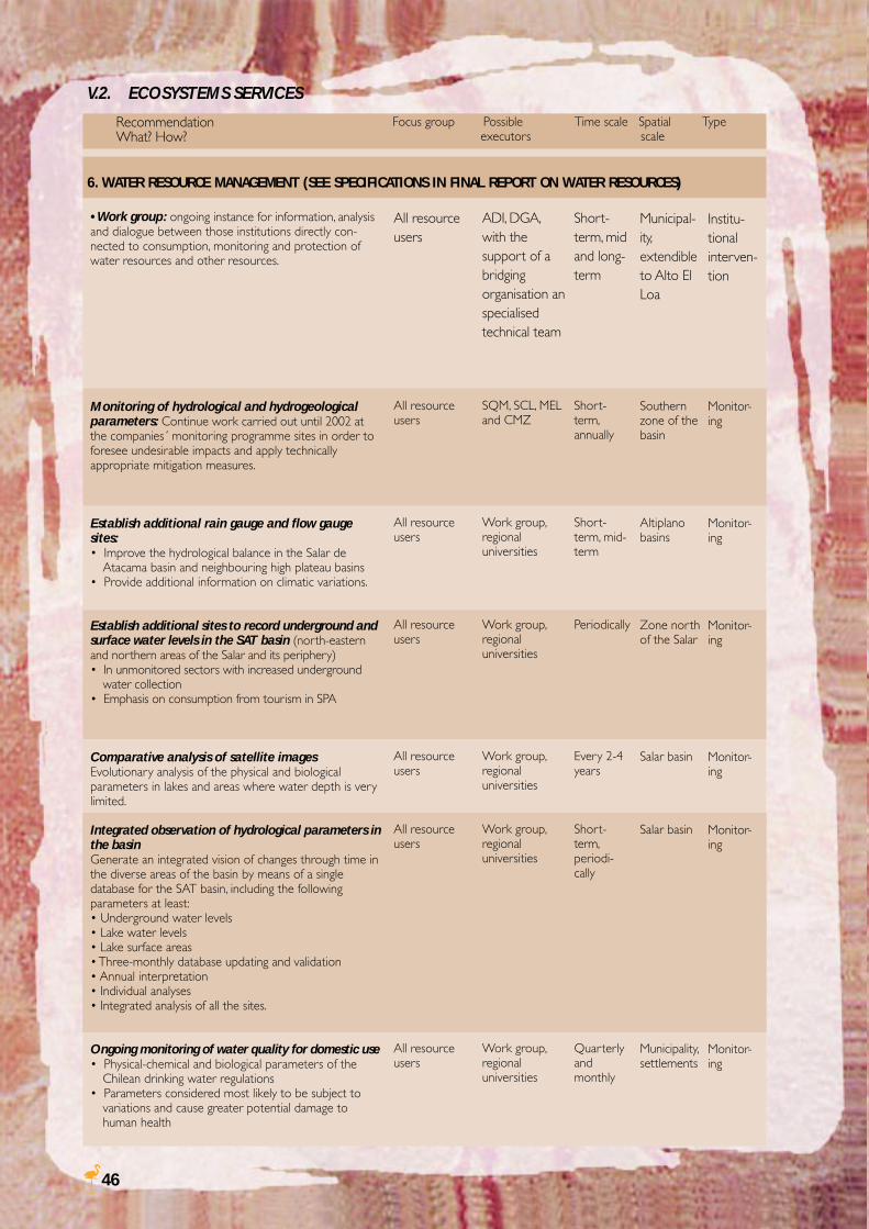
46
• Work group: ongoing instance for information, analysisand dialogue between those institutions directly con-nected to consumption, monitoring and protection ofwater resources and other resources.
Monitoring of hydrological and hydrogeologicalparameters: Continue work carried out until 2002 atthe companies´ monitoring programme sites in order toforesee undesirable impacts and apply technicallyappropriate mitigation measures.
Establish additional rain gauge and flow gaugesites:• Improve the hydrological balance in the Salar de
Atacama basin and neighbouring high plateau basins• Provide additional information on climatic variations.
Establish additional sites to record underground andsurface water levels in the SAT basin (north-easternand northern areas of the Salar and its periphery)• In unmonitored sectors with increased underground
water collection• Emphasis on consumption from tourism in SPA
Comparative analysis of satellite imagesEvolutionary analysis of the physical and biologicalparameters in lakes and areas where water depth is verylimited.
Integrated observation of hydrological parameters inthe basinGenerate an integrated vision of changes through time inthe diverse areas of the basin by means of a singledatabase for the SAT basin, including the followingparameters at least:• Underground water levels• Lake water levels• Lake surface areas• Three-monthly database updating and validation• Annual interpretation• Individual analyses• Integrated analysis of all the sites.
Ongoing monitoring of water quality for domestic use• Physical-chemical and biological parameters of the
Chilean drinking water regulations• Parameters considered most likely to be subject to
variations and cause greater potential damage tohuman health
V.2. ECOSYSTEMS SERVICES
6. WATER RESOURCE MANAGEMENT (SEE SPECIFICATIONS IN FINAL REPORT ON WATER RESOURCES)
RecommendationWhat? How?
Focus group Possible Time scale Spatial Type executors scale
All resourceusers
All resourceusers
All resourceusers
All resourceusers
All resourceusers
All resourceusers
All resourceusers
ADI, DGA,with thesupport of abridgingorganisation anspecialisedtechnical team
SQM, SCL, MELand CMZ
Work group,regionaluniversities
Work group,regionaluniversities
Work group,regionaluniversities
Work group,regionaluniversities
Work group,regionaluniversities
Short-term, midand long-term
Short-term,annually
Short-term, mid-term
Periodically
Every 2-4years
Short-term,periodi-cally
Quarterlyandmonthly
Municipal-ity,extendibleto Alto ElLoa
Southernzone of thebasin
Altiplanobasins
Zone northof the Salar
Salar basin
Salar basin
Municipality,settlements
Institu-tionalinterven-tion
Monitor-ing
Monitor-ing
Monitor-ing
Monitor-ing
Monitor-ing
Monitor-ing
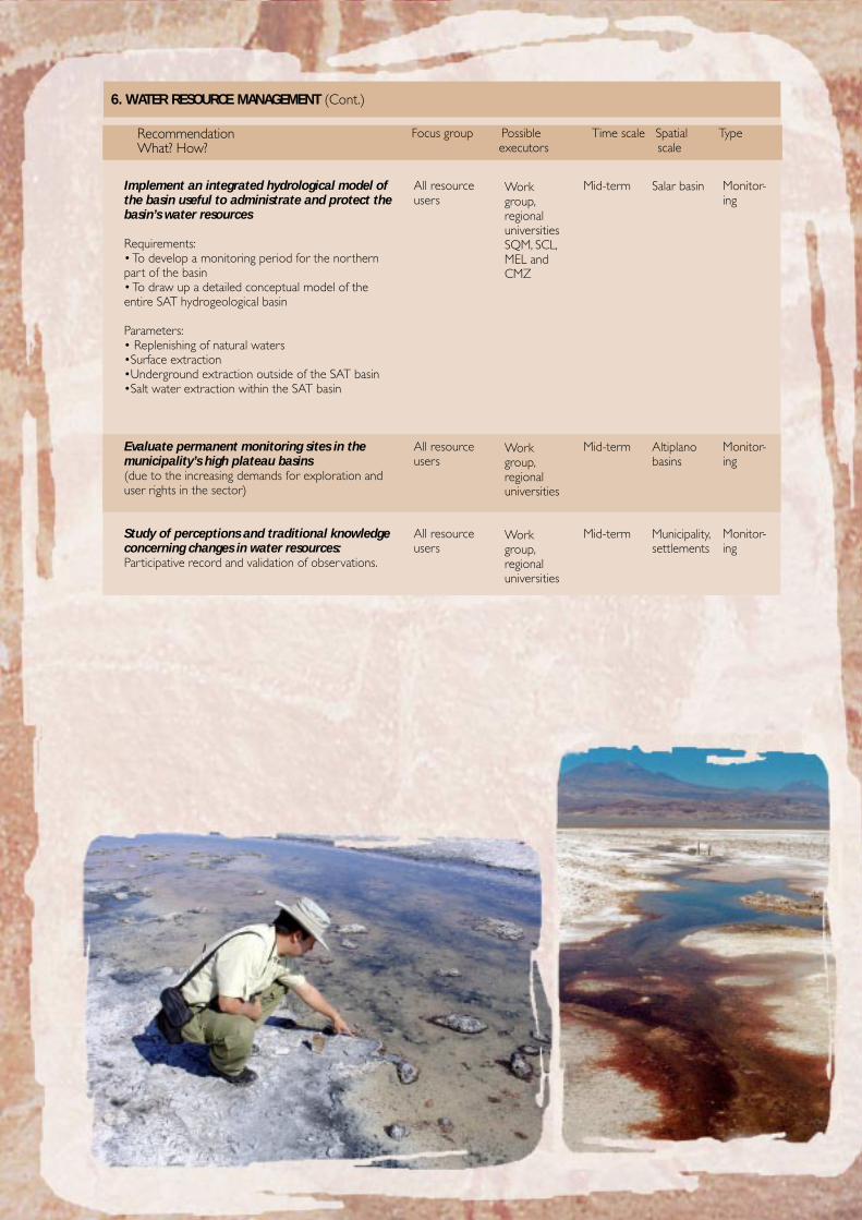
47
Implement an integrated hydrological model ofthe basin useful to administrate and protect thebasin’s water resources
Requirements:• To develop a monitoring period for the northernpart of the basin• To draw up a detailed conceptual model of theentire SAT hydrogeological basin
Parameters:• Replenishing of natural waters•Surface extraction•Underground extraction outside of the SAT basin•Salt water extraction within the SAT basin
Evaluate permanent monitoring sites in themunicipality’s high plateau basins(due to the increasing demands for exploration anduser rights in the sector)
Study of perceptions and traditional knowledgeconcerning changes in water resources:Participative record and validation of observations.
6. WATER RESOURCE MANAGEMENT (Cont.)
RecommendationWhat? How?
Focus group Possible Time scale Spatial Type executors scale
All resourceusers
All resourceusers
All resourceusers
Workgroup,regionaluniversitiesSQM, SCL,MEL andCMZ
Workgroup,regionaluniversities
Workgroup,regionaluniversities
Mid-term
Mid-term
Mid-term
Monitor-ing
Monitor-ing
Monitor-ing
Salar basin
Altiplanobasins
Municipality,settlements
48
Determine which elements constitute biodiversityin the municipality of SPA (completing base lines).• Review of species list, adding species not included
and including common names of species.
Incorporate taxonomical groups not included inthe PIEB study• Information review and update for taxonomical
groups not included in the PIEB repor t
In-depth review of “use of biodiversity”• A list of native species with patents on the commercialuse of their genetic resources
Updating of the biogeographical base of the SPAmunicipality• Documentation of most up-to-date thoughts and knowl-edge on the historical evolution of the landscape, and thecurrent distribution of flora and fauna in the municipalityof SPA
Development of a conceptual model of relation-ships between the components of biodiversity inthe Salar• Creation of a model of relationships between the
biotic and physical environments in the Salar
Development of a Geographical InformationSystem• Updating of the GIS carried out by RIDES (e.g.
vegetation formations and associations, and collec-tion priority sites).
7. BIODIVERSITY
RecommendationWhat? How?
Focus group Possible Time scale Spatial Type executors scale
CPA,Atacameñocommunities,community atlarge
CPA,Atacameñocommunities,community atlarge
CPA,Atacameñocommunities,community atlarge
CPA,Atacameñocommunities,community atlarge
CPA,Atacameñocommunities,community atlarge
CPA,Atacameñocommunities,community atlarge
RIDES, with thesupport ofCONAMA,CONAF, SAG,regional universi-ties and miningcompanies
RIDES, with thesupport ofCONAMA,CONAF, SAG,regional universi-ties and miningcompanies
RIDES, with thesupport ofOrígenes andregional universi-ties
RIDES, with thesupport ofCONAMA,CONAF, SAG,regional universi-ties and miningcompanies
RIDES, with thesupport ofCONAMA,CONAF, SAG,regional universi-ties and miningcompanies
RIDES, with thesupport ofCONAMA,CONAF, SAG,regional universi-ties and miningcompanies
Short-term
Short-term
Short-term
Short-term
Short-term
Short-term
Municipality
Municipality
Municipality
Municipality
Municipality
Municipality
Records
Records
Records
Records
Records
Records
49
Alternative energy: solar, wind powerProspective studies on strengths, weaknesses, threats andopportunities.
Water recyclingProspective studies on strengths, weaknesses, threats andopportunities.
Reverse osmosis to reduce arsenic levels in the water:Prospective studies on strengths, weaknesses, threats andopportunities of existing alternative technologies.
Organic and inorganic domestic waste recycling
8. OTHER ECOSYSTEM SERVICES
RecommendationWhat? How?
Focus group Possible Time scale Spatial Type executors scale
Local commu-nity, tourismoperators
Local commu-nity, tourismoperators
All resourceusers
All inhabitantsof the munici-pality
Departmentof MechanicalEngineeringUniversidadTécnicaFedericoSanta María(UTFSM)
Specialisedconsultant
Jack Stern -TeknoAgua
Localgovernment
Mid-term
Mid-term
Mid-term
Mid-term
Technologytransfer
Technologytransfer
Technologytransfer
Interven-tion
Municipality,settlements
Municipality,settlements
Municipality,settlements
Municipality
50
V.3. LESSONS AND RECOMMENDATIONS FOR FUTURE INITIATIVES
• There are advantages and disadvantages when intervening as an external agent. On the one hand, being an externalagent allows the team to take an impartial position in the face of the diverse interests and perceptions of local actors.However, being physically distant from the assessment area can introduce obstacles. Therefore, the identification ofa key local contact is essential.
• The creation of an advisory group is strongly recommended. This creates space for the sharing of information andfor confidence and trust building within and between government institutions and local groups.
• The personal involvement of experts throughout the participatory process positively enhances the contribution ofthese experts - as in the case of the team that worked on the water issues.
• The level of public participation is highly variable over time, and depends to a large extent on the perception thatindividuals have of the concrete benefits of their invested effort. In a project of this nature however the results areless tangible in the short term, which makes participation and its continuity difficult.
• The dissemination of preliminary assessment results amongst the stakeholders was highly valued, as was the team’sdedication to respect commitments agreed upon throughout the assessment process.
• A key question in this type of assessment is how much emphasis should be placed on the process of participation, andhow much on ‘hard’ research. The answer is situation dependent; in our case, we opted for the former, placing most ofthe emphasis on the participatory process as a platform for dialogue and a subsequent deepening of the latter.
• Extension activities proved to be successful complements to the central assessment process. These activities helpedto generate trust and confidence, and to build networks of support at the local level.
• The international exchange of experiences – such as that between South Africa and Chile for the development ofscenarios – was taken advantage of during the assessment process, and was highly valued by the participants.
• The participation of local authorities is essential to ensure the impact of the results. In our case, for both internalthan external reasons, the project lacked the necessary commitment of these actors.
• It proved difficult to translate complicated terms and concepts around ecosystems to local people. In addition, it isessential that accessible language is used, and that the entire assessment process is framed in this way.
• Taking an analysis beyond a consideration of provisioning services, by including an analysis of supporting, regulatingand cultural services, is very difficult because many of these services are intangible and therefore difficult to measure.
• A conclusive evaluation is difficult to achieve at finer scales due to the lack of adequate and accurate data at the locallevel. Therefore, a conclusive local level assessment would usually require original research.
• Although the effort to carry out an integrated assessment was cornerstone throughout the assessment process,expert training and common mental constructs still seem to be inadequate to fully capture the complex nature ofthe system under analysis.
51
VI. REFERENCES
Aquaconsult (2005). Informe final de recursos hídricos, Proyecto Bienestar Humano y Manejo Sustentable en San Pedro de Atacama (Final waterresource report, Project on Human Well-being and Sustainable Management in San Pedro de Atacama). Aquaconsult: Santiago, Chile.
Bustos, B. and H. Blanco (2004). Patta hoiri and Likanantay people: rescuing the knowledge of the land. Document prepared for the conference onepistemologies of the MA, Alexandria, Egypt. Santiago: RIDES.
Cavieres L.A., M.T.K. Arroyo, P. Posadas, C. Marticorena, O. Matthei, R. Rodriguez, F.A. Squeo & G. Aarancio (2002). Identification of priority areas forconservation in an arid zone: application of parsimony analysis of endemicity in the vascular flora of the Antofagasta region, northern Chile.Biodiversity and Conservation 11: 1.303-1.311.
Compañía Minera Zaldívar (2002). Informe de Sustentabilidad 2002.
CONAF - CONAMA – BIRF (1997). Catastro y Evaluación de los Recursos Vegetacionales Nativos de Chile (Record and Assessment of NativeVegetation Resources of Chile). Corporación Nacional Forestal, Santiago, Chile.
CONAMA (1999). Primera Comunicación Nacional bajo la Convención Marco de las Naciones Unidas sobre el Cambio Climático (FirstNational Communication within the United Nations Framework Convention of Climate Change).
Contreras, J.P. (CONAF) y M. Parada (Minera Escondida) (2004). Personal com.
MMSD South America team (2002). Minería, Minerales y Desarrollo Sustentable en América del Sur (Mining, Minerals and Sustainable Develop-ment in South America). CIPMA and MPRI: Santiago, Chile.
Government of Chile (2004). Política de Nuevo Trato con los Pueblos Indígenas. Derechos Indígenas, Desarrollo con Identidad y DiversidadCultural (Policy for New Treatment of Indigenous Peoples, Development with Identity and Cultural Diversity).
Gundermann, H. (2000). Las organizaciones étnicas y el discurso de la identidad en el norte de Chile, 1980-2000 (Ethnic organisations and thedebate on identity in the north of Chile, 1980-2000). In Estudios Atacameños no.19. Universidad Católica del Norte.
Instituto Nacional de Estadísticas – INE (National Statistic Institute) (2002). Municipality of San Pedro de Atacama, 2002 Census. Santiago, Chile.
Instituto Nacional de Estadísticas - INE (National Statistic Institute) (1998). Supplementary Income Survey. Santiago, Chile.
Instituto Nacional de Estadísticas - INE (National Statistic Institute) (1997). National Employment Survey. Corporación para el Desarrollo Productivo(Productive Development Corporation), Region of Antofagasta.
Instituto Nacional de Estadísticas - INE (National Statistic Institute) (1997). VI Agriculture and Fishing Census, 1997.
IPCC (2001). The scientific basis. Summary for policy makers. IPCC WGI Third assessment report.
Millennium Ecosystem Assessment (2003). Ecosystems and human well being: a framework for assessment. Island Press.
Minera Escondida (2003). Memoria Anual.
Ministerio de Planificación y Cooperación – MIDEPLAN (Ministry for Planning and Cooperation) (1996). Encuesta de CaracterizaciónSocioeconómica Nacional CASEN (CASEN Survey on National Socioeconomic Characteristics). www.mideplan.cl
Ministerio de Planificación y Cooperación – MIDEPLAN (Ministry for Planning and Cooperation) (1998). Encuesta de CaracterizaciónSocioeconómica Nacional CASEN (CASEN Survey on National Socioeconomic Characteristics). www.mideplan.cl
Ministerio de Planificación y Cooperación – MIDEPLAN (Ministry for Planning and Cooperation) (2000). Encuesta de CaracterizaciónSocioeconómica Nacional CASEN (CASEN Survey on National Socioeconomic Characteristics). www.mideplan.cl
Ministerio de Planificación y Cooperación – MIDEPLAN (Ministry for Planning and Cooperation) (2002). Etnias y pobreza en Chile. Análisis de laVIII Encuesta de Caracterización Socioeconómica Nacional (Ethnic groups and Poverty in Chile. Analysis of the VIII National SocioeconomicCharacteristics Survey (Casen 2000) Document no.14.
United Nations Development Programme - UNDP (2000). Desarrollo Humano en las Comunas de Chile (Human Development in thecommunes of Chile). MIDEPLAN.
SERNAGEOMIN (National Geology and Mining Service) (2003). Compendio de la minería chilena 2003 (2003 Chilean Mining Compendium).Editec Limitada.
Sernatur (National Tourism Service) (2002). Compendio Estadístico 1997-2001.
Sistema Nacional de Indicadores Municipales SINIM (National System of Municipal Indicators). Ministerio del Interior (Home Office), SUBDEREwww.sinim.cl
SQM (2005). Sitio web: http://www.sqm.cl/espanol/NC recursos. htm
Valenzuela, R. (2003). Inequidad, ciudadanía y pueblos indígenas en Chile (Inequality, citizenship and indigenous peoples in Chile). CEPAL – SocialDevelopment Division. Social Policy Series no.76.
Villagrán, C., Castro, V., Sanchéz, G., Romo, M., Latorre, C. and Hinojosa, L.F. 1998. La tradición surandina del desierto: Etnobotánica del Salar deAtacama (Provincia de El Loa, Región de Antofagasta, Chile), Estudios Atacameños 16
The following products and results were developed within the framework of the project “Human well-being and sustainable management in San Pedro de Atacama”:
• Publications and documents
- Final executive report (the present document; so available in Spanish).- Base line reports on water resources, tourism, biodiversity, agriculture, mining, astronomical observato-ries and human well-being.- Article presented at the Alexandria Conference on traditional knowledge: “Patta hoiri and Likanantaypeople: rescuing the knowledge of the land” Beatriz Bustos and Hernán Blanco, 2004.- Multimedia CD with reports, presentation and video.
• Geographical Information System for the municipality of SPA
The GIS contains a series of specialised information collated for the project base lines. It thereforerepresents a full presentation of factors such as water resources, tourist sites, agriculture, protected areasand mining in the municipality. This product will be supplied in CD form, along with a user manual andfree visualisation software. Access to the information will be free, in the hope it will be a useful tool fordecision-making and territorial planning in both public and private initiatives.
• Geographical Information System on irrigation in SPA and nearby settlements (ayllus)
This GIS was developed in cooperation with the Comisión Nacional de Riego (National Irrigation Com-mission) in SPA as part of the report on water resources. It integrates all available information onirrigation in the town of San Pedro de Atacama and its surroundings.
• Video “Patta hoiri and Likanantay people: rescuing the knowledge of the land”
This video is an approach towards the traditional knowledge of the Atacameño people on the ecosys-tem and its riches, carefully held in the memories of the elders. It contains a record of the two meetingsheld in San Pedro de Atacama and Toconao, when the elders shared their memories, legends and tradi-tions on the sky, the volcanoes, the water and the land with children and adolescents from the commu-nity. This material was given to all the schools in the municipality, the participating communities, theauthorities and regional and national institutions, for educational purposes.
• Use of solar energy
The project helped channel the donation of two solar water heating systems by the Universidad TécnicaFederico Santa María to a community tourism venture hostel in Machuca and a large low-income familyin Camar. A follow-up investigation was carried out to assess the social, environmental and economicimpacts of the use of these systems and evaluate their receptivity and possible replication in the zone.
• International exchanges
Over the course of the project, we had diverse visitors from abroad linked with the MA: Marcus Lee andCiara Raudsepp-Hearne, from the MA General Secretariat; Georgina Cundill, from the South Africansubglobal assessment (SAfMA); and Tian Xiang Yue and Zhan Jingyan, from the Eastern China subglobalassessment (MAWEC). The visitors travelled to the municipality and participated in advisory committeemeetings, sharing their work and experiences with the participants.
The documents drawn up within the framework of the project can be viewed at our web page:www.rides.cl or requested by post at the following address:
Andrés Marín Project CoordinatorRIDES - Andrés de Fuenzalida 22, Oficina 801, Providencia, Santiago, Chile
Tel: 56-2-2317565 - Fax: 56-2-2300616Email: [email protected]