crÉditos - surdoc
TRANSCRIPT


CRÉDITOS
DIRECCIÓN DE BIBLIOTECAS, ARCHIVOS Y MUSEOS (DIBAM) 2011
DIRECTORA Y RESPONSABLE LEGAL: Magdalena Krebs Kaulen
MUSEO HISTÓRICO NACIONAL
Director: Diego Matte P.
ISBN: 978-956-7297-13-9
Propiedad Intelectual Nº 210.755
INVESTIGACIÓN Y TEXTOS: Juan Manuel Martínez
EDICIÓN DE TEXTOS: Isabel Alvarado, Leonardo Mellado, Elizabeth Shaeffer.
COLABORACIÓN REVISIÓN DE TEXTOS: Carolina Barra, Grace Standen.
FOTOGRAFÍAS: Juan César Astudillo, Marina Molina.
DISEÑO, DIAGRAMACIÓN Y EDICIÓN DE FOTOGRAFÍAS: Incubo
IMPRESIÓN: Editora e Imprenta MAVAL Ltda.
PROYECTO
Financiamiento: Acciones Culturales DIBAM 2011
Coordinación General: Isabel Alvarado
Administración: Marta López
MUSEO HISTÓRICO NACIONAL
Plaza de Armas 951, Santiago de Chile
www.museohistoriconacional.cl
IMAGEN PORTADADetalle de litografía A Series of Panoramic Views of Santiago, The Capital of Chili. Vistas Panorámicas de Santiago, la Capital de Chile. Dibujo de William Waldegrave, litografía de Agostino Aglio. John Boosey, Londres 1823.Colección Museo Histórico Nacional
EL PAISAJE CHILENOITINERARIO DE UNA MIRADAColección de Dibujos y Estampas del Museo Histórico Nacional

La presente publicación: “El paisaje chileno.
Itinerario de una mirada”, se realiza en el
contexto de la celebración de los cien años de
la creación del Museo Histórico Nacional. Esta
importante conmemoración, busca mostrar a
la comunidad las diversas labores que realiza
el museo, como lo son la documentación,
investigación, conservación y difusión
del patrimonio que resguarda. Lo cual, se
logra a través de las distintas exposiciones,
publicaciones y actividades de extensión, que
realiza permanentemente.
Las colecciones del Museo, constituyen
una fuente inagotable para la investigación
de diversas disciplinas, ya que cada uno
de los objetos que las componen, contiene
información que puede ser analizada, desde
distintos puntos de vista. Así, es posible
estudiar procesos y desarrollos históricos,
científicos, tecnológicos y artísticos, entre otros.
La mirada del artista, del científico y del viajero,
es lo que encontraremos en este libro. Un
interesante estudio del paisaje, de nuestro
territorio, y de su construcción cultural, a través
de una delicada y exhaustiva selección de
dibujos, grabados y mapas, pertenecientes a
la Colección de Dibujos y Estampas del Museo
Histórico Nacional.
Los llamados “artistas viajeros”, recorrieron
el actual territorio nacional acompañados
por expediciones de carácter eminentemente
científico. En sus viajes, realizaron dibujos,
bocetos y grabados de los paisajes, los que les
permitieron registrar las distintas costumbres
de los aborígenes, sus fiestas y ceremonias.
De este modo, entonces, se realizaba una
labor documental, además de artística. Cabe
mencionar, que estas obras, son producto del
interés de estudiosos europeos, que motivados
por el espíritu “romántico”, imperante en
la época - a fines del siglo XVIII y XIX -
se sentían especialmente atraídos por las
exploraciones y las particularidades de los
territorios. En especial, si estos eran nuevos y
de carácter “exótico”.
Esta publicación, posee un formato
especialmente atractivo, a nivel de imágenes y
contenidos, lo que le permite ser un material de
divulgación y difusión masiva. Concordando,
así, con las políticas institucionales,
desarrolladas por el Museo Histórico Nacional.
Con esta investigación, se busca cum- plir
diversos objetivos. Por una parte, el deleite
estético del lector, al contemplar estas
notables imágenes y, por otra, ser un aporte al
conocimiento, tanto de la historia, como de las
representaciones artísticas, de la identidad de
nuestro país.
Isabel Alvarado Perales
Directora (S)
Museo Histórico Nacional
FOREWORD
This publication, The chilean landscape. Itinerary of a perspective, was written as part of the celebration of the hundredth anniversary of the Museo Histórico Nacional’s founding. This important commemoration seeks to showcase the museum’s diverse missions, including documentation, investigation, conservation, and public outreach. These aims are achieved through expositions, publications and other cultural activities that the museum sponsors throughout each year.
The collection of the Museo constitutes an inexhaustible resource for the investigation of a diversity of disciplines, since each of the objects contains information that can be analyzed from distinct points of view. Thus, it is possible to study a wide range of processes and developments, spanning the historical, scientific, technological, and artistic.
The perspectives of the artist, the scientist and the traveler are interpreted in this book. It is an interesting study of landscape, of our territory, and of its cultural construction, through a delicate and exhaustive selection of drawings, prints and maps that form part of the Collection of Drawings and Prints of the Museo Histórico Nacional.
The so-called “traveler artists” explored the national territory accompanied by expeditions that were primarily scientific in nature. On
their voyages, they made drawings, sketches and prints of the landscapes, along with the different customs of the native inhabitants, their festivals and ceremonies. In this way, their work was documentary in addition to being artistic. It is worth mentioning that these pieces are the result of interest by studious Europeans, who motivated by the “romantic” spirit that prevailed in the late 18th and 19th centuries, felt attracted to the explorations and details of the territories, especially if these were new and “exotic” in nature.
This publication possesses an attractive format, in terms of images and content, that endows it with the ability to serve as a tool for effectively spreading and diffusing knowledge and information, in concordance with the institutional policies developed by the Museo Histórico Nacional.
With this investigation, we hope to accomplish a number of objectives. On the one hand, to provoke the aesthetic delight of the reader upon contemplating these remarkable images, and on the other, to contribute to the understanding, both of the history and of the artistic representations, of the identity of our country.
Isabel Alvarado PeralesInterin Director
Museo Histórico Nacional
2 3
PRESENTACIÓN
EL PAISAJE CHILENOITINERARIO DE UNA MIRADA
INTRODUCCIÓN pag. 7
CAPÍTULO IEl reconocimiento del paisaje en la historia visual de Chilepag. 11
CAPÍTULO IICiencia y arte, el despertar de la exploración de la naturaleza remotapag. 39
CAPÍTULO IIIItinerario de la mirada, la descripción de un nuevo territorio pag. 67
CAPÍTULO IVLos pintores viajeros, entre la visión científica y la perspectiva artísticapag. 95
CAPITULO V Cartografía y paisaje, la medida de la naciónpag. 123
CAPÍTULO VI El triunfo del paisajepag. 160
THE CHILEAN LANDSCAPETINERARY OF A PERSPECTIVE
INTRODUCTIONpg. 9
CHAPTER IRecognizing the landscape in Chilean visual history pg. 14
CHAPTER II Science and art, the exploration of remote nature awakenspg. 45
CHAPTER IIIItinerary of a perspective, the description of a new territorypg. 72
CHAPTER IVTraveling painters, between scientific vision and artistic perspectivepg. 100
CHAPTER VCartography and landscape, the measure of the nationpg. 128
CHAPTER VIThe triumph of landscape pg. 168
ÍNDICE INDEX
5
EL PAISAJE CHILENOITINERARIO DE UNA MIRADAColección de Dibujos y Estampas del Museo Histórico Nacional

INTRODUCCIÓN
El contexto histórico y cultural de la irrupción
del paisaje en la historia del arte en nuestro
país, correspondió al proceso de conocimiento
y dominio de un territorio, que lentamente
ocupado por parte del Imperio español, a partir
del siglo XVI, no terminó de conocerse sino
hasta los últimos decenios del siglo XIX. (Fig.1)
Dibujos, mapas y grabados dieron origen a un
corpus de obras que comenzó a dar cuenta de
un nuevo territorio, como también de un modo
de explicarlo. El desarrollo tecnológico en las
técnicas artísticas, como el grabado en sus
diferentes aplicaciones, en especial la litografía,
junto con la instalación definitiva5 del manejo de
la perspectiva en el dibujo y la pintura, otorgaron
mayor verosimilitud a las visiones del paisaje.
En la historia del arte, el paisaje estuvo
enmarcado en la denominada pintura de género,
un arte menor en comparación a los temas
mitológicos o históricos, considerados éstos
como un arte mayor. No obstante, en el siglo
XVIII, con el fenómeno de las expediciones
científicas y la expansión comercial imperial
europea, se valoró la temática del paisaje,
especialmente basada en una ilustración
descriptiva de la mirada de viajeros y de
artistas que participaban en ellas, las que
r Fig. 1Observatoire de Port Famine (Detroit de Magellan)Observatorio de Puerto de Hambre (Estrecho de Magallanes)París, 1846Litografía/Huella 225 x 378 mm/Hoja 306 x 454 mmMHN 3-2763Dibujo de Louis Lebreton, con figuras de Juan Bautista Bayot, lito-grafía de León Baptiste Sabatier e impreso por Lemercier.
posteriormente se publicaron. Relaciones de
viajes y atlas, con cartografías más exactas,
contribuyeron a la representación de estos
nuevos territorios. El arte se puso al servicio de
la ciencia, a fin de divulgar imágenes inéditas
de un continente, que para Europa era remoto.
El colapso y ocaso del Imperio español en
América se hizo evidente en el segundo
decenio del siglo XIX. Las nuevas naciones,
en las que se incluía Chile, después de
lograr su independencia, buscaron definir
sus nuevos ámbitos geográficos y políticos.
La emancipación política trajo consigo una
apertura comercial, aprovechada por europeos
y norteamericanos, la que determinó un
flujo continuo de expediciones científicas y
comerciales. Debido a la posición geográfica
de Chile, en referencia a las rutas del Estrecho
de Magallanes, el país se convirtió en destino y
visita obligada de estas exploraciones.
Las imágenes producidas como resultado
de ellas, fueron realizadas por una variedad
de autores, algunos de ellos, parte de las
tripulaciones a bordo de las expediciones,
en otros casos por hombres de ciencias,
especialmente botánicos y por supuesto por
pintores, dibujantes y grabadores, contratados
7
especialmente para generar representaciones
de los diferentes lugares recorridos en las
diversas exploraciones. A éstos se sumaron
los artistas viajeros, hombres influídos por
el romanticismo decimonónico, arriesgados
aventureros que fueron seducidos por la belleza
y lo monumental del paisaje local, entre los que
se encontraron Borget y Rugendas.
Pero, el naciente estado chileno, también se
hizo responsable de reconocer su territorio, por
lo que contrató a Claude Gay y Amado Pissis,
quienes nos legaron obras fundamentales sobre
nuestra nación. Finalmente, la autonomía del
género del paisaje, se puede visualizar en la
obra del artista nacional Antonio Smith, quien
abrió un nuevo ciclo en la relación del paisaje
con las Bellas Artes.
La imagen, en la era de la reproductibilidad,
fue fundamental para que el público europeo
y norteamericano, conociera paisajes, pueblos
y costumbres remotas. Esto determinó un
tipo de imagen convencional, basada en
apuntes y bocetos presenciales, donde se
entregaba una información visual. Sin duda,
algunas imágenes, fueron realizadas desde
una visión eurocéntrica, donde se mezclaban
realidades de otras latitudes. En cambio otras,

nos entregan una valiosa información sobre el
entorno cultural de una época pasada.
Resulta interesante constatar que la temática
del paisaje esté siendo, actualmente, motivo de
reflexión para el mundo de la filosofía y de las
ciencias sociales, en general. Como por ejemplo
la obra de Mathieu Kessler1 o en el caso de la
cartografía con la obra La nueva naturaleza de
los mapas, sobre el pensamiento de J.B. Harley.2
Se debe hacer una mención especial a la
obra de Simon Schama,3 en el ámbito de
los estudios históricos-culturales, donde se
plantea, que a través de un viaje en el tiempo
y el espacio, se puede examinar la relación del
hombre con el paisaje y el impacto que tiene
esta imagen en la cultura y en la construcción
del imaginario de una comunidad. La naturaleza
y la percepción humana se unen, al constituirse
el paisaje como un producto de la mente, el
que se construye a partir de los diferentes
estratos de la memoria. Es así, como el paisaje
es la expresión visible de un orden (natural
y geográfico), el que comprende al hombre.
No es sólo un monumento natural, sino que
expresa, fisonómicamente, una organización
donde el hombre formó parte de todo ello.
Se plantea que éste es un discurso de la
memoria, es el juego de las relaciones entre
paisaje, historia e identidad, que se integran
en el concepto del paisajismo geográfico
moderno, iniciado por Humboldt y continuado
por geógrafos del siglo XIX.4
Lo que se propone en esta lectura, es la
revisión de ciertos hitos, a través de la
colección de dibujos, grabados y mapas del
Museo Histórico Nacional, que nos plantea una
interpretación sobre el rol de la imagen, como
un discurso.5 Donde la representación del
paisaje, no sólo evolucionó hacia un realismo,
sino hacia una interpretación artística, que hoy
nos la apropiamos constituyéndose en una
memoria de identidad.
INTRODUCTION
The historical and cultural context for the emergence of landscape in the history of art in Chile is linked with the process of exploration and control of territory that was gradually occupied by the Spanish Empire. Although these discoveries began in the 16th century, they were not completed until the last decades of the 19th century. (Fig. 1)
Drawings, maps and engravings became part of a body of work that revealed and explained a new territory. The technological development of artistic techniques such as engraving (in its different applications, especially lithography) and the definitive establishment of the use of perspective for drawing and painting endowed these landscape scenes with greater verisimilitude.
In the history of art, landscape had always been part of so-called genre painting, a lesser form of art in comparison with mythological or historical themes, which were considered “great art.” However, during the 18th century, a time of scientific expeditions and European commercial and imperial expansion, the field of landscape art began to acquire value as a descriptive illustration of the scenes observed by the travelers and artists who participated in these expeditions, and who went on to publish their
works. Accounts of journeys and atlases with more accurate cartographies contributed to the visual representation of these new territories. Art was put to the service of science as a way to share unprecedented images of a continent far distant from Europe.
The collapse and demise of the Spanish Empire in America occurred during the second half of the 19th century. After achieving their independence, the young nations –including Chile– sought to establish new geographic and political frontiers. Political emancipation also opened up commercial routes that were used by Europeans and North Americans, and which produced a continuous flow of scientific and commercial expeditions. Due to its geographic position in relation to the routes through the Straight of Magellan, Chile was a mandatory destination for these expeditions.
The images produced as a result were created by a variety of authors, some of them part of the crews on board the expeditions, others men of science (especially botanists), and of course painters, draftsmen and engravers who were hired to generate representations of different aspects of these expeditions. These men were joined by
8 9

CAPITULO I
EL RECONOCIMIENTO DEL PAISAJE EN LA HISTORIA VISUAL DE CHILE
La construcción visual del paisaje en Chile, sin
duda, se debe a las obras que realizaron los
viajeros y expedicionarios científicos que visitaron
el país, básicamente en los siglos XVIII y XIX.
El resultado de estos viajes, se plasmó
en dibujos y grabados que se publicaron
en las diversas relaciones y atlas sobre
viajes y expediciones. Este corpus de
dibujos y grabados, que fué la base de las
investigaciones de Eugenio Pereira Salas, abró
un rico y denso repertorio de obras y autores,
que dió cuenta del paisaje del país. Pereira,
tanto en su obra Historia del Arte del Reino de Chile,6 donde se centró principalmente en
los artistas de la expedición de Malaspina,
como en su obra póstuma, Estudios sobre la historia del arte en Chile republicano,7 en
la cual se explayó sobre la temática de los
artistas viajeros, logró revisar gran parte de
las obras de estos artistas. Específicamente,
en el capítulo La iconografía de Chile en el siglo XIX,8 Pereira Salas, se centró en la formación
de una nueva iconografía en Chile del siglo
XIX, que fue resultado de las expediciones
científicas que llegaron a nuestro país, y
los artistas oficiales participantes en ellas,
o los viajeros que contribuyeron al cambio
iconográfico en esa época. (Fig. 2)
Para este autor la curiosidad científica, sumada
a la búsqueda de nuevos mercados comerciales,
son los aspectos esenciales para el éxito de
la literatura de viajes. Los responsables de
estas publicaciones, son generalmente, los
encargados de las expediciones que, al regreso
de sus viajes, editaban textos científicos y
descripciones geográficas en Europa y Estados
Unidos. Para una mayor comprensión de estas
publicaciones, por parte del lector, se incluían
grabados litográficos realizados por los artistas
oficiales (pintores, bocetistas, dibujantes y
grabadores) que formaban parte de estas
expediciones. (Fig.3)
Pereira analizó otras investigaciones,9 donde
se afirmaba que entre las representaciones
realizadas por los artistas viajeros en el siglo
XIX, se hizo presente una gran variedad
de paisajes y representaciones, como los
panoramas a la inglesa, paisajes artísticos,
vistas, view o veduta, paisajes desérticos,
mediterráneos, andinos, antárticos y
australes. No solo fue la escenificación de
un paisaje exento de algún otro elemento, ya
que se les sumó la representación de tipos
humanos, escenas costumbristas y paisajes
urbanos.10(Fig.4)
De esta forma, los artistas oficiales que
recorrieron tanto Chile, como otros países en
el continente americano, así como Australia,
Oceanía y Asia, realizaron dibujos, bocetos
y grabados de los paisajes, costumbres de
aborígenes y aspectos de la vida cotidiana de
la población. Fue en los primeros decenios
del siglo XIX que las representaciones
iconográficas vigentes hasta la época, fueron
cambian5do desde el exotismo barroco y
elegancia neoclásica a representaciones de
los rasgos etnográficos de los habitantes y su
entorno de manera más exacta; cambiando
el sentido de la representación del buen salvaje de Rousseau, tan propios de fines del
siglo XVIII y comienzos del siglo XIX, en las
representaciones humanas.11
A esta visión iconográfica del país, se sumó
un tema de gran novedad para la época en
la representación de paisajes, el llamado
ciclo antártico, (Fig.5) basado en las nuevas
visiones y formas de representación con
paisajes y fauna de la Antártida, territorio
antes desconocido. También la representación
del ciclo polinésico, en las que se incluyó la
Isla de Pascua.
El viaje realizado y relatado por Dumont
D’Urville en las naves Zelée y Astrolabe
(1837–1840), (Fig.6) cierra el ciclo de la
pintura etnográfica: con la idea romántica,
traveling artists who were influenced by 19th century Romanticism, risky adventurers who were seduced by the beauty and monumental scale of the local landscape; these included Borget and Rugendas.
But the nascent Chilean state also took responsibility for discovering its own territory and hired Claude Gay and Amado Pissis, who created works that were essential to the nation’s origins. Finally, the autonomy of the landscape genre may be appreciated in the work of national artist Antonio Smith, who began a new cycle in the relationship between landscape and fine arts.In the age of reproduction, the image was essential for European and North American audiences to learn about remote landscapes, peoples and customs. This led to the development of a conventional type of image, based on personal notes and sketches, which served to provide visual information. Undoubtedly, some images were produced from a Eurocentric perspective, mixing that which was observed with realities from other latitudes. Other artists, on the other hand, provided valuable information regarding the cultural surroundings of a past era.
It is interesting that the topic of landscape has only recently become an issue on which the world of philosophy and social science has begun to reflect. This is illustrated, for
10 11
example, in the work of Mathieu Kessler1 and in the case of cartography, the book La nueva naturaleza de los mapas, about the ideas of J.B. Harley.2
The work of Simon Schama3 in the field of historical-cultural studies must be mentioned; he claimed that by traveling through time and space, one may examine mankind’s relationship with the landscape and the impact this image has had on culture and the construction of the community and collective mind. Nature and human perception are combined, since landscape is a product of the mind, built using different layers of memory. Thus, landscape is the visible expression of a natural and geographic order that includes mankind. It is not only a natural monument, but also expresses physiognomic ally an organization in which mankind forms part of a whole. This is thought to be a discourse of memory, an interplay of relationships between landscape, history and identity, which was integrated into the concept of modern geographic landscape initiated by Humboldt and continued by 19th century geographers.4
What this text proposes is to review certain historical events through a collection of drawings, engravings and maps belonging to the Museo Histórico Nacional, with an interpretation of the role of the image as a
discourse.5 The representation of the landscape not only evolved towards realism, but towards an artistic interpretation which today is assumed as part of our identity and memory.

que destacó el exotismo, avanzando así hacia
la transcripción de la naturaleza de manera
más fiel y detallada.12 (Figs.7, 8) Sin duda un
elemento que ayudó a esta fidelidad al modelo,
fue que estos artistas hicieron uso de la cámara
lúcida durante su producción, como una
ayuda técnica para mejorar la representación
de sus dibujos. (Figs.9, 10) Entre los artistas
de esta expedición, se cuenta a; A. Legrand,
Ernest Auguste Le Goupil (1814–1840) y Louis
Lebreton (1818-1861). Le Goupil fue uno de los
artistas más destacados en la representación
iconográfica de la Antártida, Patagonia y parte
de Tierra del Fuego. (Fig. 11)
En oposición al naturalismo y fidelidad
científica13 se encuentra la obra de los
grabadores Giovanni Batista Cipriani (1720–
1785) y Francesco Bartolozzi (1730–1813)
(Fig.12), que con sus representaciones de
los habitantes de las diversas regiones
visitadas, desfiguraron la realidad, al vestir a
los indios con ropajes neoclásicos. Motivo
que hace sostener, como un ejemplo, que
en las ilustraciones de la Colección de Viajes,
del editor de libros inglés John Hawkesworth,
se mantuvo ciertamente, la idea de la
representación del buen salvaje, propias del
siglo XVIII.
De la expedición científica de Hyacynthe de
Bouganville en la fragata Thetis, se destacó el
oficial, Vizconde Edmond Bigot de la Touanne
(1796-1882), un artista topográfico que
contribuyó a la iconografía con 34 ilustraciones
y viñetas para el Journal de Navigation o en la
publicación realizada posteriormente, en 1828,14
en cuyas litografías se representó los paisajes
y sus habitantes de diferentes zonas del litoral
como los paisajes entre Valparaíso y Santiago y
sus alrededores.15 (Fig.13, 14)
En 1831, en la expedición científica de la
Favorite, (Fig.15) se destacó al pintor bocetista
e ilustrador francés, Barthélemy Lauvergne
(1805-1871), (Fig.16) quien reflejó en sus
representaciones los paisajes de la región
con detalladas características topográficas,
y representaciones de habitantes de las
ciudades visitadas.
Ilustrativas son las vistas de los alrededores
de Valparaíso, realizadas en el contexto de
la expedición al mando del capitán Auguste-
Nicolas Vaillant (1793-1858), quien realizó un
periplo alrededor del mundo, recorriendo la
costa americana del Pacifico de sur a norte,
cruzando el océano Pacífico desde California
a las Filipinas, China y la India. Los dibujos
fueron publicados en Voyage autor du monde exécute pendant les années 1836 a 1837 sur la corvette La Bonite, por Nicolas Vaillant en
Paris, 1841. A esto se sumaron los dibujos de
Theodore Auguste Fisquet, que luego pasaron
a la litografía de Joly, con figuras de Adolphe
Jean Baptiste Bayot e impreso por Lemercier,
Benard y Cie en París. (Fig.17), como también
los dibujos de Barthélemy Lauvergne (1805-
1871). (Figs.18,19)
Además de las expediciones científicas de
países europeos, también hubo expediciones
que venían desde Estados Unidos de
América, siendo la del Comodoro Charles
Wilkes, entre los años 1838 y 1842, la
primera en visitar el país. En su publicación
Narrative to the United States Exploring Expedition, uno de los artistas americanos
que acompañó esta expedición científica fue
Joseph Drayton (1795 - 1856), el cual era
en su país un destacado grabador, impresor,
ilustrador y pintor. En esta expedición fue
acompañado por otro artista norteamericano,
el pintor y miniaturista Alfred Thomas Agate
(1812 – 1846).16
Una segunda expedición norteamericana visitó
el país entre 1849 y 1852, y tuvo la finalidad
de realizar observaciones astronómicas de
Marte y Venus. La expedición partió del puerto
de Baltimore en junio de 1849 con destino a
Valparaíso, bajo el mando del teniente James
Melville Gilliss, y fue publicada en Washington
en 1855.17
En Santiago, Gilliss fue recibido por el
entonces ministro de Relaciones Exteriores
José Joaquín Pérez, a quien solicitó le
indicara un lugar donde poder instalar todo
el equipamiento técnico para el trabajo
científico. El lugar elegido fue el costado
norte del Cerro Santa Lucía. (Fig. 20) de lo
que hay testimonio en un grabado en el que
aparece el rocoso cerro, con el observatorio
en su cumbre, y la vista de una ciudad con
exuberante vegetación, dibujo de James
Queen, dibujante y litógrafo norteamericano
(1824 - c. 1877), quien se formó trabajando
para Duval & Lehman de Filadelfia. El grabado
fue realizado por la casa P.S Duval & Co., de
propiedad de Peter S. Duval, litógrafo francés
(1804-1886), quien se instaló en Filadelfia,
primero como grabador y luego creando una
gran imprenta litográfica.
De esta expedición, hay una imagen tomada de
una obra pictórica de Juan Mauricio Rugendas,
Lago de Aculeo, grabada por James Queen
(Fig.21). No sólo se tomaron vistas de Chile
Central, sino también del Norte, como es el caso
de una vista del puerto de Caldera. (Fig. 22).
En esta expedición se utilizó la naciente
técnica de la fotografía para capturar
imágenes y luego, a través del daguerrotipo,
realizar una ilustración y reproducirla. Un
ejemplo de ello es la obra de John Mix
Stanley (1814-1872) quien fue uno de los
artistas-exploradores más destacados de la
escena artística y editorial norteamericana,
cuya obra se centró en el paisaje del
oeste y la representación de los nativos
12 13
norteamericanos en las grandes praderas. En
el caso de Chile se posee una extraordinaria
representación de un jefe mapuche, con una
detallada indumentaria, en un contexto de
paisaje local. (Fig.23)
Pereira analyzed other investigations9 which claimed that the representations created by traveling artists during the 19th century included a great variety of landscapes including English-style panoramas, artistic landscapes, vedutas or “views”, desert, Mediterranean, Andean, Antarctic, and southern landscapes. These were not however, only descriptions of landscape, lacking in other elements. They also included the human figures, costumbrista scenes and urban landscapes.10 (Fig. 4)
Thus, the official artists traveling throughout both Chile and other countries in the Americas, as well as Australia, Oceania and Asia, created drawings, sketches and engravings of the landscapes, indigenous customs and aspects of the populations’ daily lives. In the first decades of the 19th century, the popular iconographic representations shifted from baroque exoticism and neoclassical elegance to more exact representations of the ethnographic features of the inhabitants and their surroundings; changing the sense of the representation of Rousseau’s noble savage, so common among human representations of the late 18th century and early 19th century. 11
This iconographic vision of the country was joined by a very novel theme for the period, in terms of the representation of landscapes: the so-called Antarctic cycle, (Fig. 5) based
on new ideas and forms of representation with landscapes and fauna from Antarctica, a formerly unknown territory, as well as the representation of the Polynesian cycle, which included Easter Island.
The journey made and related by Dumont D’Urville on the ships Zelée and Astrolabe (1837-1840) (Fig. 6) closes the cycle of ethnographic painting: the romantic ideal, which highlighted exoticism, advanced towards the transcription of nature in the most faithful and detailed manner.12 (Figs. 7, 8) Without doubt, a factor that contributed to the fidelity of this model was that these artists used the camera lucida as a technical aid for improving the representations in their drawings. (Figs. 9,10) The artists on this expedition included A. Legrand, Ernest Auguste Le Goupil (1814-1840) and Louis Lebreton (1818-1861). Le Goupil was one of the most prominent artists in the iconographic representation of the Antarctic, Patagonia and part of Tierra del Fuego. (Fig. 11)
In opposition to this naturalism and scientific fidelity13 were the works of the engravers Giovanni Batista Cipriani (1720-1785) and Francesco Bartolozzi (1730-1813) (Fig. 12), whose representa- tions of the inhabitants of diverse regions included natives dressed in neoclassical clothing, distorting reality. This suggests, for example, that the illustrations in the Colección de Viajes, by the English
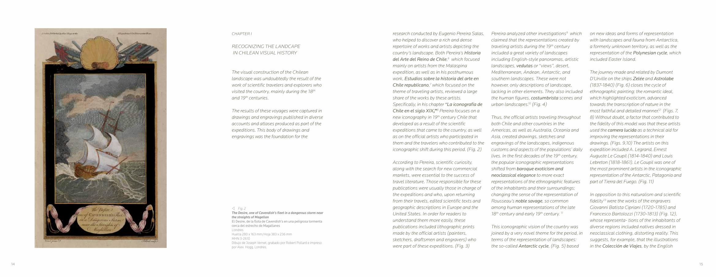
v Fig. 2 The Desire, one of Cavendish’s fleet in a dangerous storm near the straights of MagellanEl Desire, de la flota de Cavendish’s en una peligrosa tormenta cerca del estrecho de MagallanesLondres Huella 280 x 163 mm/Hoja 383 x 236 mmMHN 3-2610Dibujo de Joseph Vernet, grabado por Robert Pollard e impreso por Alex Hogg, Londres.
CHAPTER I
RECOGNIZING THE LANDCAPE IN CHILEAN VISUAL HISTORY
The visual construction of the Chilean landscape was undoubtedly the result of the work of scientific travelers and explorers who visited the country, mainly during the 18th and 19th centuries.
The results of these voyages were captured in drawings and engravings published in diverse accounts and atlases produced as part of the expeditions. This body of drawings and engravings was the foundation for the
research conducted by Eugenio Pereira Salas, who helped to discover a rich and dense repertoire of works and artists depicting the country’s landscape. Both Pereira’s Historia del Arte del Reino de Chile,6 which focused mainly on artists from the Malaspina expedition, as well as in his posthumous work, Estudios sobre la historia del arte en Chile republicano,7 which focused on the theme of traveling artists, reviewed a large share of the works by these artists. Specifically, in his chapter “La iconografía de Chile en el siglo XIX,”8 Pereira focuses on a new iconography in 19th century Chile that developed as a result of the scientific expeditions that came to the country, as well as on the official artists who participated in them and the travelers who contributed to the iconographic shift during this period. (Fig. 2)
According to Pereira, scientific curiosity, along with the search for new commercial markets, were essential to the success of travel literature. Those responsible for these publications were usually those in charge of the expeditions and who, upon returning from their travels, edited scientific texts and geographic descriptions in Europe and the United States. In order for readers to understand them more easily, these publications included lithographic prints made by the official artists (painters, sketchers, draftsmen and engravers) who were part of these expeditions. (Fig. 3)
14 15

editor John Hawkesworth, maintained the 18th century idea of the representation of the noble savage.
The scientific expedition of Hyacynthe de Bouganville on the frigate Thetis featured the Viscount Edmond Bigot de la Touanne (1796-1882), a topographical artist who contributed to this iconography with 34 illustrations and vignettes for the Journal de Navigation and a later publication from 1828,14 in which his lithographs represented the landscapes and inhabitants of the different coastal zones, including the landscapes between Valparaíso and Santiago and their surroundings.15 (Fig. 13,14)
In 1831, the scientific expedition aboard the corvette La Favorite (Fig. 15) included the French painter, sketcher and illustrator, Barthélemy Lauvergne (1805-1871), (Fig. 16) whose works reflected the landscapes of the region with detailed topographical characteristics and representations of the inhabitants of the cities visited.
Scenes of Valparaiso’s surroundings are particularly illustrative, made during the expedition commanded by Captain Auguste-Nicolas Vaillant (1793-1858), who made a long voyage around the world, exploring the Pacific coast of the Americas from south to north, crossing the Pacific Ocean from California, and then went on to the
Philippines, China and India. These drawings were published in Paris by Nicolas Vaillant in 1841, in Voyage author du monde exécute pendant les années 1836 a 1837 sur la corvette La Bonite. This was complemented by the drawings of Theodore Auguste Fisquet, which were later included in the lithographs of Joly, with figures by Adolphe Jean Baptiste Bayot, and printed by Lemercier, Benard et al in Paris, (Fig. 17), as well as by the drawings of Barthélemy Lauvergne (1805-1871). (Fig.18, 19)
Besides the scientific expeditions from European countries, there were also expeditions arriving from the United States. The first of these to visit the country was headed by Commodore Charles Wilkes between 1838 and 1842. In his publication, Narrative to the United States Exploring Expedition, one of the American artists on the scientific expedition was Joseph Drayton (1795-1856), a prominent engraver, printer, illustrator, and painter. On this expedition, he was accompanied by another North American artist, the painter and miniaturist Alfred Thomas Agate (1812 – 1846).16
A second U.S. expedition visited the country between 1849 and 1852, aiming to conduct astronomical observations of Mars and Venus. The expedition set sail from the port of Baltimore in June 1849 towards
Valparaíso, under the command of Lieutenant James Melville Gilliss, and the documentation was published in Washington D.C. in 1855.17
In Santiago, Gilliss was received by then-Minister of Foreign Affairs José Joaquín Pérez, whom he asked to suggest a place to install the technical equipment for his scientific work. The chosen place was the northern side of Santa Lucía Hill. (Fig. 20) This is confirmed by an engraving that shows the rocky hill with an observatory on the summit overlooking a city with exuberant vegetation, a drawing by James Queen, an American draftsman and lithographer (1824-c.1877) who received training while working for Duval & Lehman in Philadelphia. The engraving was made by the P.S Duval & Co., owned by Peter S. Duval, a French lithographer (1804-1886) who settled in Philadelphia as an engraver and who later founded a lithographic printing press.
From this expedition, there is an image copied from a painting by Juan Mauricio Rugendas, Lago de Aculeo, which was engraved by James Queen (Fig. 21). The scenes were not limited to Central Chile however, but also depicted the North, as is the case with a view of the port of Caldera. (Fig. 22)
This expedition used the newly invented technique of photography to capture images
w Fig. 3 M. Bougainville hoisting french colours on a small rock in Magellan streightsM.Bougainville izando los colores franceses en una pequeña roca en el Estrecho de MagallanesLondres Calcografía/Huella 285 x 162 mm/Hoja 385 x 228 mmMHN 3-2609Dibujo de Vangro, grabado en cobre de Royce e impreso por Alex Hogg, Londres.
and later, using a daguerreotype, make a print and reproduce it. One example of this is a piece by John Mix Stanley (1814-1872), who was one of the most distinguished artist-explorers on the U.S. artistic and editorial scene, whose work focused on Western landscapes and Native North Americans of the Great Plains. In Chile, he was responsible for producing an extraordinary representation of a Mapuche chief with detailed clothing in the context of a local landscape. (Fig. 23)
16 17

r Fig. 4 La Corbeta Atrevida entre bancos de nieveMadrid, 1798Litografía/Huella 335 x 513 mm/Hoja 475 x 630 mmMHN 3-2740Dibujo y grabado por Fernando Brambila
w Fig. 5Las fragatas Astrolabe y Zelee en los hielos antárticos, 1838Louis LebretonSepia sobre papel: 100 x 150 mmMHN 3-1723
18 19

r Fig.6Mouillage des corvettes sur la baie Saint-Nicolás (Detroit de Magellan)Fondeadero de las corbetas en la bahía de San Nicolás (Estre-cho de Magallanes)París, 1846Litografía/Hoja 354 x 547 mmMHN 3-2781Dibujo de Louis Lebreton, litografía de Louis Philippe Alphon-se Bichebois y Auguste Etienne François Meyer e impreso por Lemercier, Benard et Co.
w Fig. 7 Fond du Port Galant (Détroit de Magellan)Fondeadero del Puerto Galant (Estrecho de Magallanes)París, 1846Litografía/Huella 217 x 308 mm/Hoja 355 x 545 mmMHN 3-2745Dibujo de Louis Lebreton, litografía de León Jean Baptiste Saba-tier e impreso por Lemercier, Benard et Co.
20 21
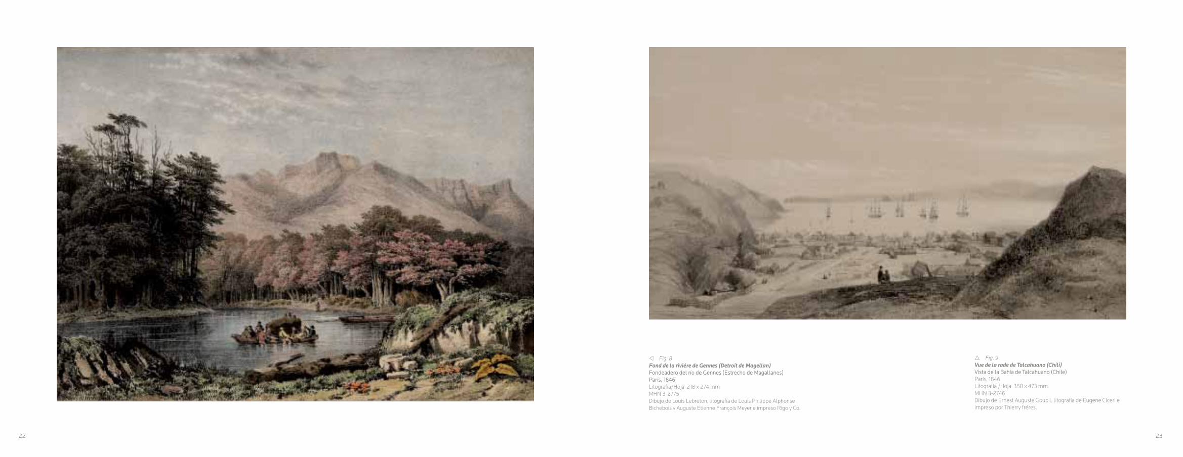
v Fig. 8Fond de la riviére de Gennes (Detroit de Magellan)Fondeadero del río de Gennes (Estrecho de Magallanes)París, 1846Litografía/Hoja 218 x 274 mmMHN 3-2775Dibujo de Louis Lebreton, litografía de Louis Philippe Alphonse Bichebois y Auguste Etienne François Meyer e impreso Rigo y Co.
r Fig. 9 Vue de la rade de Talcahuano (Chili)Vista de la Bahía de Talcahuano (Chile)París, 1846Litografía /Hoja 358 x 473 mmMHN 3-2746Dibujo de Ernest Auguste Goupil, litografía de Eugene Ciceri e impreso por Thierry fréres.
22 23

r Fig. 10 Pont de Santiago sur le río Mapocho (Chili)Puente de Santiago sobre el río Mapocho (Chile)Paris, 1828Litografía /Huella 193 x 277 mm/Hoja 345 x 472 mmMHN 3-2748Dibujo de Edmond Bigot de la Touanne, figuras por Víctor Jean Adam, litografía de León Jean Baptista Sabatier e impreso por Benard y Frey.
w Fig. 11Navire baleinier en appareillage dans un havre du Detroit de MagellanBarco ballenero en franquia en una ensenada del Estrecho de MagallanesLitografía /Hoja 400 x 540 mmMHN 3-2756Dibujo de Louis Lebreton, litografía de Turgis
24 25
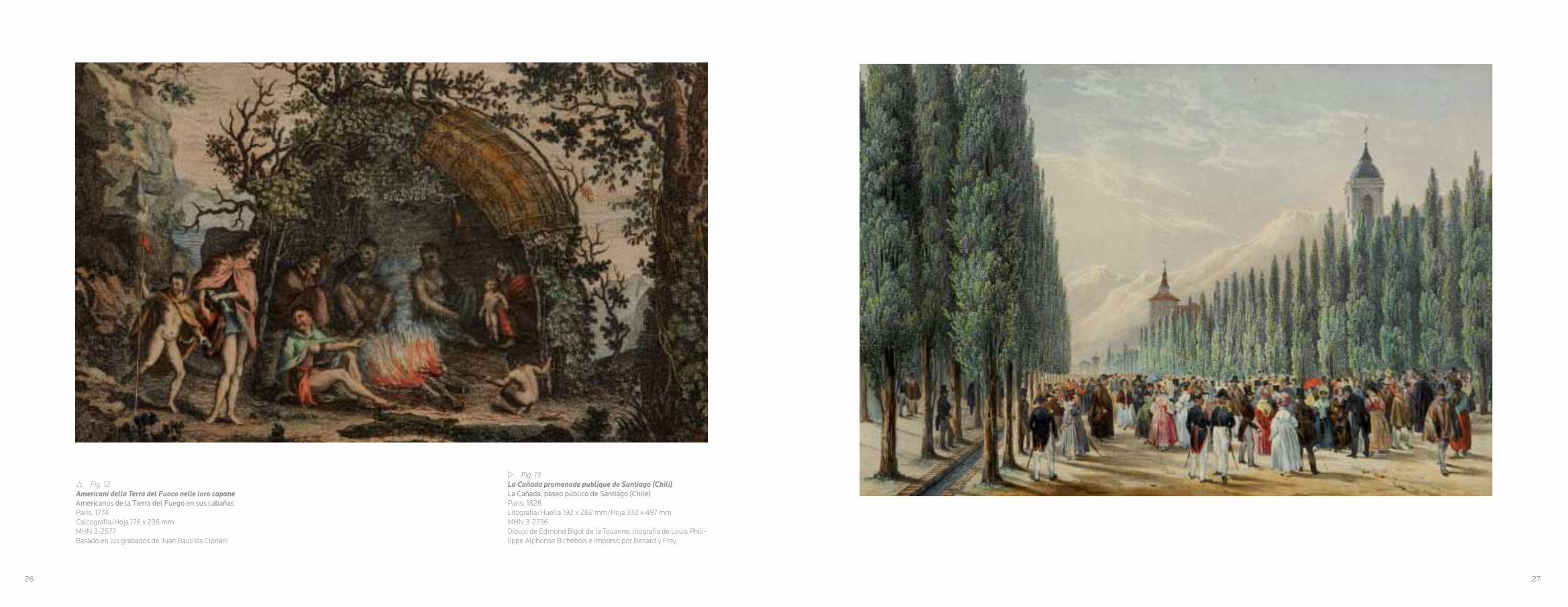
r Fig. 12 Americani della Terra del Fuoco nelle loro capaneAmericanos de la Tierra del Fuego en sus cabañasParís, 1774 Calcografía/Hoja 176 x 236 mmMHN 3-2577Basado en los grabados de Juan Bautista Cipriani
w Fig. 13La Cañada promenade publique de Santiago (Chili)La Cañada, paseo público de Santiago (Chile)Paris, 1828Litografía/Huella 192 x 282 mm/Hoja 332 x 497 mm MHN 3-2736Dibujo de Edmond Bigot de la Touanne, litografía de Louis Phili-lippe Alphonse Bichebois e impreso por Benard y Frey.
26 27

v Fig. 14Guasos des environs de Valparaiso et Santiago (Chili)Huasos de los alrededores de Valparaíso y Santiago (Chile)París, 1828Litografía/Huella 192 x 272 mm/Hoja 335 x 490 mmMHN 3-2770Dibujo de Edmond Bigot de la Touanne, figuras por Víctor Jean Adam, litografía de León Jean Baptista Sabatier e impreso por Benard y Frey.
r Fig. 15La Favorite (en route pour Valparaíso)La Favorite (en ruta a Valparaíso)Paris, 1835Litografía/Hoja 270 x 365 mmMHN 3-2742Dibujo de Barthélemy Lauvergne, litografía Sigismond Himely, e impreso por Finot.
28 29

r Fig. 16ValparaísoParis, 1835Litografía/Huella 293 x 380 mm/Hoja 310 x 470 mmMHN 3-2754Dibujo de Barthélemy Lauvergne, litografía Sigismond Himely, e impreso por Finot.
w Fig. 17Environs de Valparaíso (Chili)Alrededores de Valparaíso (Chile)Paris, 1841Litografía/Huella 250 x 330 mm/Hoja 318 x 485 mmMHN 3-3738Dibujo de Theodore Auguste Fisquet, litografía de Joly con fi-guras de Adolphe Jean Baptiste Bayot e impreso por Lemercier, Benard y Cie.
30 31
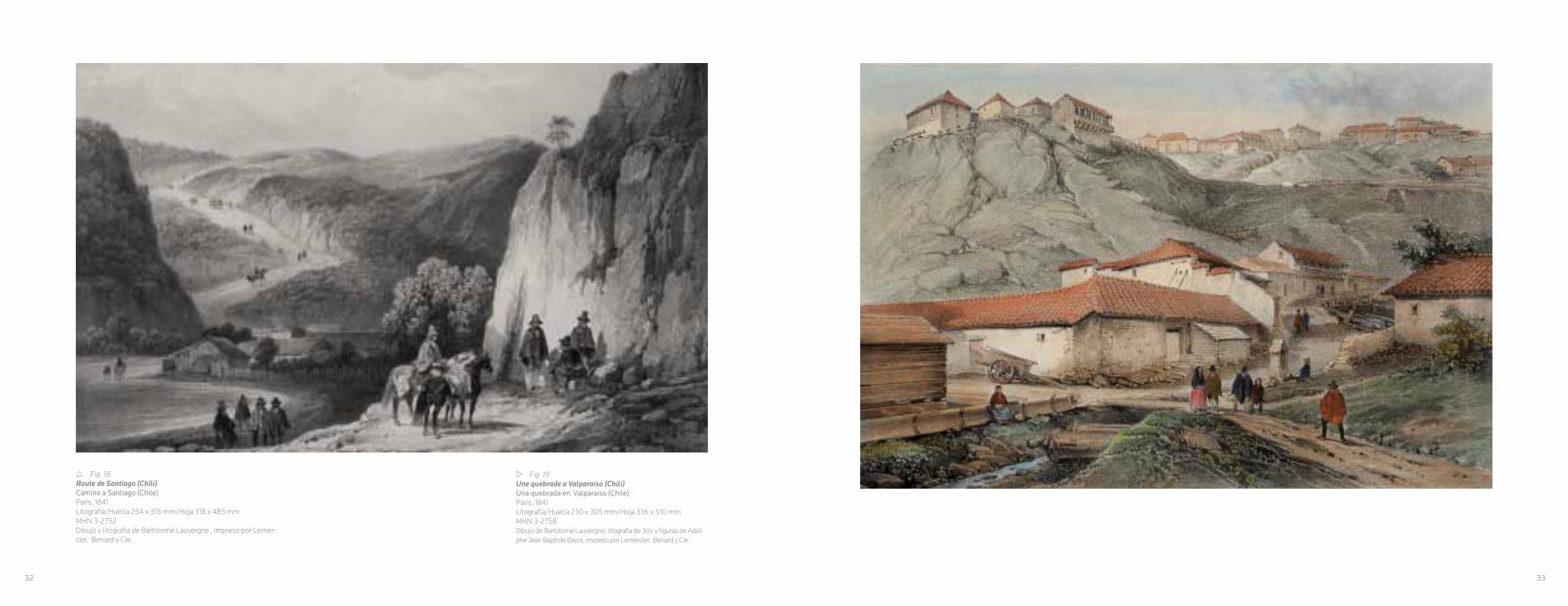
r Fig. 18Route de Santiago (Chili)Camino a Santiago (Chile)Paris, 1841Litografía/Huella 254 x 315 mm/Hoja 318 x 485 mmMHN 3-2752Dibujo y litografía de Bartolomé Lauvergne , impreso por Lemer-cier, Benard y Cie.
w Fig. 19Une quebrade a Valparaíso (Chili)Una quebrada en Valparaíso (Chile)Paris, 1841Litografía/Huella 230 x 305 mm/Hoja 336 x 510 mmMHN 3-2758Dibujo de Bartolomé Lauvergne, litografía de Joly y figuras de Adol-phe Jean Baptiste Bayot, impreso por Lemercier, Benard y Cie.
32 33

r Fig. 20Santa LucíaFiladelfia, 1855Grabado/Hoja 217 x 292 mmMHN 3-36902Dibujo de James Queen, litografía de P.S. Duval & Co., Filadelfia
w Fig. 21Lake AculeoLago AculeoFiladelfia, 1855Grabado/Hoja 220 x 285 mmMHN 3-36900Dibujo de James Queen, litografía de P.S. Duval & Co., Filadelfia
34 35

v Fig. 22Caldera in 1852Caldera en 1852Filadelfia, 1855Grabado/Hoja 285 x 227 mmMHN 3-36901Litografía P.S. Duval & Co., Filadelfia
w Fig. 23Araucanian ChiefJefe AraucanoFiladelfia, 1855Grabado/Hoja 285 x 227 mmMHN 3-36899Pintura de John Mix Stanley de un daguerrotipo, litografía de P.S. Duval & Co., Filadelfia
36 37

CAPITULO II
CIENCIA Y ARTE, EL DESPERTAR DE LA EXPLORACIÓN DE LA NATURALEZA REMOTA
Desde la cima de la cuesta de Prado el panorama es muy interesante. A la derecha se extiende el gran valle donde está Santiago, el cual termina en los Andes, montañas de prodigiosa altura y cuya cima está cubierta de nieves eternas. Al frente, la región no es menos digna de verse; distinguíamos gran número de casas…18
El siglo XVIII, fue el epicentro del inicio de
las grandes empresas exploratorias, como
fue el caso de George Vancouver19, quien
entre los años 1790 a 1795 organizó y realizó
un gran periplo por el Océano Pacífico.
Poseía una gran experiencia en estos
viajes, debido a su participación anterior en
otros que realizó alrededor del mundo con
James Cook. Sintetizó sus experiencias de
Pozo, realizado en el marco de la expedición
de Malaspina, un autorretrato del artista en su
tarea de registrar a través del dibujo, el entorno
paisajista y a los habitantes patagones. (Fig.24)
La mirada imperial europea, frente a la realidad
del mundo americano, usó sus parámetros
culturales para leer e interpretar las costumbres
locales. (Figs. 25, 26,27)
Pero sin duda, fue en el contexto del Siglo de las luces, donde el mundo europeo comenzó
con las exploraciones científicas y su desarrollo
a gran escala. En este sentido, la Academia
de las Ciencias de París, organizó en 1735 una
expedición para examinar la verdadera forma y
dimensión de la Tierra. Esta pretendía resolver
si la Tierra era una esfera, según la cartografía
cartesiana francesa, o una esfera achatada
en sus polos, según lo planteaba Newton.21
En el contexto de la unidad dinástica entre
Francia y España, se solicitó permiso a Felipe
V para poder recorrer los territorios imperiales
españoles en América, ante lo cual dos
científicos fueron incorporados a la expedición
al mando de Charles Marie de la Condamine,
ellos fueron Jorge Juan y Antonio de Ulloa.
Esta expedición científica, fue un reflejo de
lo que se vivía en el siglo XVIII, motivada en
ciertos aspectos, por la rectificación de los
mapas, debido al desarrollo científico de los
instrumentos de navegación y por el desafío
v Fig. 24 Autorretrato en Magallanes, 1790José del PozoTinta y sepia sobre papel/180 x 260 mmMHN 3-1733
viaje, las que se publicaron en Londres en
1798. Vancouver no vio su obra impresa,
sino que fue su hermano John con otros
compañeros de travesía, quienes finalizaron
su compilación y edición. En su último viaje,
en 1795, visitó Valparaíso y Santiago, en
momentos en que el Reino de Chile tenía
como gobernador a Ambrosio O’Higgins.
Al respecto, la experiencia visual de Vancouver,
no se alejaba de las visiones de sus
contemporáneos, al sintetizar elementos de las
visiones convencionales de los modelos europeos
sobre el paisaje. Como también, una manera de
reunir en una imagen, diferentes aspectos de una
región, que en muchos casos, tiene su correlato
en una narración del texto de dichas expediciones
científicas. La descripción del paisaje estaba
supeditada a la asociación entre el clima y su
relación con la producción del lugar. Por esa
razón las ilustraciones de estos viajes cumplieron
un papel fundamental, ya que las imágenes:
…fueron consideradas como medios privilegiados para cumplir una función ordenadora y normativa, por su capacidad de recoger y organizar la experiencia visual.20
Estos relatos tienen un hilo común: la
descripción del territorio y sus habitantes,
siguiendo la lógica del diario de viaje, lo que se
ve reflejado en los grabados, dibujos y mapas.
Un ejemplo de ello, es el dibujo de José del
38 39

v Fig. 25Habitants du Detroit de Magellan, nommes patagons; leurs barques, leurs chaumines.Habitantes del Estrecho de Magallanes, llamados patagones: sus barcas, sus cabañas.Grabado/Huella 201 x 155 mm/Hoja 272 x 195 mmMHN 3-2602Dibujo de Charles Nicolas Cochin Le Jeune, grabado por Jacques Jean Pasquier, en la segunda mitad del siglo XVIII, sin referencias.
de fijar rutas. Especialmente, en el área del
Estrecho de Magallanes,22 para abrir vías
comerciales y nuevos mercados. El abate Juan
Ignacio Molina, dio cuenta de la importancia de
estas expediciones en su obra “Compendio de la historia geográfica natural y civil del Reyno de Chile”, publicado en Madrid en 1788:
La Europa vuelve al presente toda su atención hacia la América, deseando conocer con erudita curiosidad la diversidad de sus climas, la estructura de sus montes, la naturaleza de sus fósiles, la forma de sus vegetales y de sus animales y en suma, todo lo que puede empeñar su atención en aquellas varias regiones. 23
Fundamentalmente la razón de esta expansión
fue la necesidad de las grandes potencias
imperiales, de expandir sus dominios coloniales,
pero se sumó a ésto la idea de conocer
científicamente, un mundo remoto y exótico,
poblados de paisajes de una fauna y flora que
Europa no terminaba de dominar.(Fig. 28)
En este estilo de imagen, estructurada en
el marco de una representación clásica de
la exploración imperial, se encuentran las
imágenes publicadas en 1748, en el relato de la
travesía a cargo de Richard Walter, capellán del
Centurión, de la expedición de George Anson,24
(Fig. 29) la que incluía 42 láminas grabadas,
que fueron publicadas en Londres. La imagen:
Vista de la tienda de campaña del comodoro en la isla Juan Fernández, del grabador inglés
J.Mason, da cuenta de un paisaje de la isla de
Juan Fernández, siguiendo un modelo inglés,
en el sentido de la perspectiva, no obstante
haciendo notar un fondo montañoso y el detalle
del campamento, como la avanzada científica
en un territorio ignoto. Estas imágenes se
volvieron populares, realizándose posteriormente
ediciones en otros idiomas.(Figs. 30,31)
La expedición francesa, a cargo de Jean
François Galaup, conde de La Pérouse (1741-
1788), quien por disposición del rey Luis XVI,
realizó un viaje de circunnavegación, para
completar los descubrimientos realizados por
James Cook en el área del Océano Pacifico. La
Pérouse zarpó de Brest en 1785 con dos navíos;
la Boussole y l’Astrolabe, en cuya tripulación
figuraban científicos y artistas. El resultado de
esta expedición, se vio reflejada en el Atlas de la
Relation du Voyage autour du monde, publicado
en París en 1797. En esta publicación aparece la
imagen Trajes de los habitantes de La Concepción,
un trabajo de Gaspar Duche de Vancy, dibujante,
pintor y grabador, contratado en 1785 para la
expedición y de Jean Michel Moreau Le Jeune.
La imagen sintetiza la presencia de los diferentes
grupos sociales de Chile. (Fig. 32) En un primer
plano se aprecia la elite: hombres y mujeres,
denominados en esa época, Españoles de Chile,
marcando una diferencia con el peninsular.
Este estamento de la elite criolla, según esta
representación; se vestía con ciertas prendas
locales, como son el poncho, en el caso de los
hombres y vestidos cortos, medias, mantillas y
accesorios, en el tocado del vestuario femenino.
En el segundo plano tipos populares con un
vestuario más simple y de fondo, la cita al
paisaje de la bahía de Concepción. Estas
láminas se volvieron muy populares, y en el caso
de ésta, tuvo réplicas posteriores, creando un
estereotipo iconográfico local. (Fig.33)
A fines del siglo XVIII, la actividad comercial y
de exploraciones en el Océano Pacífico, tanto
de Inglaterra como Francia, se fueron haciendo
más hegemónicas, el Imperio español miró
con preocupación este fenómeno, ya que sus
dominios: las Filipinas por el oriente y las
costas americanas por el poniente, eran parte
de su imperio, donde la monarquía hispana
considera este mar como suyo.
En otro aspecto, la Ilustración española veía
los resultados de las expediciones científicas,
especialmente la de James Cook y la francesa
de La Pérouse, en torno al incremento de las
En este ámbito expedicionario, aparecieron
grandes repertorios de imágenes sobre los
habitantes de los territorios australes del
imperio español. Un ejemplo de ello es la
imagen: Modo de hacer las matanzas en Chile, españoles en el traje de Chile, publicado
en la Relación histórica del viaje hecho por
orden de Su Majestad a la América Meridional, Madrid 1748, de Jorge Juan y Antonio de
Ulloa. En ella, podemos apreciar el paisaje,
marco referencial permanente para todas las
expediciones europeas, con una escena de
trabajo ganadero y la visión de lobos marinos
y otros pájaros, además de las “minas de concha”, que se refiere a los conchales, lugares
donde existieron asentamientos humanos
prehispánicos. En un sector de la imagen,
aparecen dos personajes vestidos como
europeos, pero con los tradicionales ponchos,
indumentaria muy popular en el Chile del siglo
XVIII. Esta representación respondió a ciertos
convencionalismos, ya que es una manera de
reunir en una imagen, diferentes aspectos de
una región, como una narración similar al texto,
resultado de las exploraciones científicas.
Por esa razón, el papel que cumplieron
las ilustraciones de estos viajes fueron
fundamentales, ya que permitieron resumir
la experiencia visual de un recorrido
expedicionario. La imagen fue realizada
por Diego de Villanueva y grabado por
Juan Peña, grabador de las Reales Casas
de Moneda de España.
40 41

w Fig. 26Roggeween (Idole dans L’Ile des Paques)Roggenween (Ídolo en la isla de Pascua)Grabado/Hoja 163 x 260 mmMHN 3-2729Grabado por Bayalus y Descartes, sin referencias.
ciencias naturales y en definitiva del desarrollo
económico del Imperio, como también la
construcción de nuevas cartas y mapas.
Con este sentido, bajo el reinado de Carlos
III, zarparon del puerto de Cádiz, en 1789,
las naves Atrevida y Descubierta, al mando
del marino de origen napolitano Alejandro
Malaspina y José Bustamante y Guerra.
Expedición que se extendió hasta su regreso
en 1794, entonces bajo el reinado de Carlos IV.
Los resultados de la exploración, se conocieron
por el informe realizado por Malaspina, con el
título;Viaje político-científico alrededor del mundo,
donde se entregaron dibujos, pinturas y mapas,
como también lo recolectado en la expedición,25
publicándose definitivamente en 1885.26 (Fig. 34)
De esta expedición se debe resaltar la calidad
plástica de las imágenes, en especial las
realizadas por el italiano Ferdinando Brambilla,
cuyo nombre se españolizó por el de Fernando
Brambila (1763-1832), (Fig. 35) quien participó
en la expedición, embarcándose en el puerto
de Acapulco. A su regreso a España, colaboró
en la realización de una serie de grabados en
base a los apuntes y pinturas hechos por él y los
otros artistas, específicamente los realizados por
Felipe Bauzá. En 1798, Brambila fue nombrado
pintor de cámara de Carlos IV. (Fig.36)
Durante la guerra contra los franceses,
Brambila realizó la renombrada serie de
la destrucción de la ciudad de Zaragoza.
Luego fue pintor de cámara de Fernando
VII y se integró como académico a la Real
Academia de San Fernando, donde fue
nombrado Director de Perspectiva y del Adorno,
publicando en 1817 el Tratado de principios elementales de perspectiva. Desarrolló en
su obra la perspectiva, lo que se denota en
la construcción plástica de sus paisajes,
escorzos, contraste de luces y claroscuros,
construyendo composiciones más elaboradas.
En una de sus imágenes, Vista del Callejón de la Guardia en la falda Occidental de la Cordillera de los Andes, (Fig.37) se aprecia el trabajo de
la perspectiva y valorización de claroscuros
aplicados al paisaje, (Fig.38), a diferencia de la
opinión de Pereira, sobre cierta monotonía en
su composición.27
En el ocaso del Imperio español en América,
Chile recibió a la expedición dirigida por el
capitán Otto von Kotzebue (1787-1846),
auspiciada por el canciller del Imperio Ruso,
conde Nikolai P. Romanzof, cuyo objetivo era
buscar un paso por el Mar de Bering, lo que
significó estudiar las costas del Pacífico Sur
y de Alaska. De esta expedición se puede
destacar una vista de la ciudad de Concepción
en 1816, en cuyo primer plano se ven los
tipos humanos, elemento característico de las
imágenes producidas por las expediciones
científicas. Tomada de un dibujo de Louis
Choris, litografía de de Bode, e impreso bajo la
dirección de Noel y Cía. (Fig.39)
Con la Independencia, las barreras impuestas
por la monarquía hispana desaparecieron,
por lo que Chile fue visitado por sucesivas
expediciones científicas europeas. Una de
las expediciones francesas, fue la que estuvo
al mando de los capitanes, Hyacinthe Yves
Philippe Florentin de Bougainville (1781-1846) al
mando de Le Thétis y de Paul Anne Nourquer-
Ducamper, de la L’Esperance, cuyos relatos
y litografías fueron publicados en París, en
1828. En sus litografías, se percibe la idea de
un paisaje con una mirada científica, pero a la
misma vez artística, (Fig. 40) donde se desarrolló
una espacialidad, a través de la perspectiva.
Acercándose a la mitad del siglo XIX, las
expediciones francesas se hicieron frecuentes,
una de ellas fue la realizada entre 1836 y 1837,
a bordo de La Bonite, comandada por Auguste-
Nicolas Vaillant (1793-1858). Una expedición
que visitó las costas del Pacífico, produciendo
imágenes de extraordinaria calidad pictórica,
como fueron las realizadas en las vistas de la
bahía de Cobija. (Figs. 41,42)
42 43

v Fig. 27Entrevue du Commodore Byron avec les Patagons Entrevista del Comodoro Byron con los PatagonesParís, 1774Calcografía/Hoja 203 x 360 mmMHN 3-2578Grabado por R. de Launay. sin referencias.
CHAPTER II
SCIENCE AND ART, THE EXPLORATION OF REMOTE NATURE AWAKENS
The view from the top of Cuesta de Prado is very interesting. To the right, the great valley that contains Santiago stretches all the way to the Andes range, whose phenomenally high mountains are covered with eternal snows. Straight ahead, the view of the region is no less impressive; we spotted a great number of houses…
The 18th century marked the beginning of the great exploratory expeditions. This was the case with George Vancouver,19 who organized and directed a long voyage on the Pacific Ocean between 1790 and 1795. Vancouver had gained experience in these types of voyages by participating in other journeys around the world with James Cook. He synthesized his travel experience in three large volumes and an atlas called “A voyage of discovery to the North Pacific Ocean and round the world in which the coast of north-west America has been carefully examined and accurately surveyed,” which was published in London in 1798. Vancouver however, did not live to see his work published. The compilation and editing of these volumes was completed by his brother
John and two travel companions. On his last journey in 1795, Vancouver visited Valparaíso and Santiago at a time when the Reino de Chile was governed by Ambrosio O’Higgins.
In many respects, Vancouver’s visual expe- rience was similar to that of his contemporaries. He used the conventional vision of European landscape models to synthetize elements, portraying different aspects of a specific region in a single image often to complement the textual narration of these scientific expeditions. His description of the landscape and its details was associated with the climate and its relationship to production. For this reason, the illustrations made during these journeys played a fundamental role, since images:
…were considered effective means for perfor- ming an organizational and normative function, as they were capable of depicting and arranging the visual experience.20
These narratives share a common thread: the description of the land and its inhabitants following the logic of the travel journal, which is reflected in engravings, drawings and maps. One example of this is a drawing by José del Pozo, made during the Malaspina expedition. It is a self-portrait of the artist as he records the inhabitants of Patagonia and surrounding landscape in his drawing. (Fig. 24)
44 45
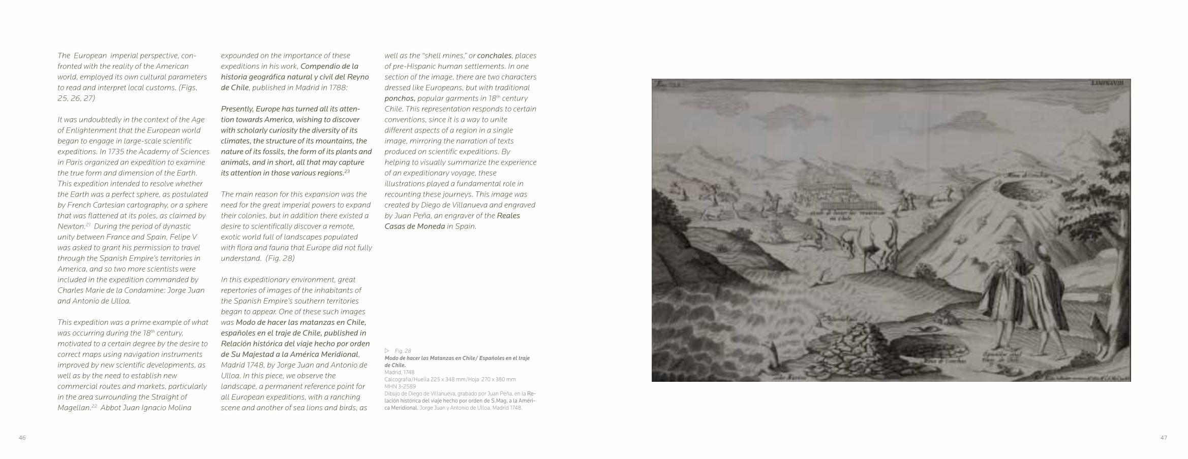
w Fig. 28Modo de hacer las Matanzas en Chile/ Españoles en el traje de Chile.Madrid, 1748Calcografía/Huella 225 x 348 mm/Hoja 270 x 380 mmMHN 3-2589Dibujo de Diego de Villanueva, grabado por Juan Peña, en la Re-lación histórica del viaje hecho por orden de S.Mag. a la Améri-ca Meridional. Jorge Juan y Antonio de Ulloa, Madrid 1748.
expounded on the importance of these expeditions in his work, Compendio de la historia geográfica natural y civil del Reyno de Chile, published in Madrid in 1788:
Presently, Europe has turned all its atten- tion towards America, wishing to discover with scholarly curiosity the diversity of its climates, the structure of its mountains, the nature of its fossils, the form of its plants and animals, and in short, all that may capture its attention in those various regions.23
The main reason for this expansion was the need for the great imperial powers to expand their colonies, but in addition there existed a desire to scientifically discover a remote, exotic world full of landscapes populated with flora and fauna that Europe did not fully understand. (Fig. 28)
In this expeditionary environment, great repertories of images of the inhabitants of the Spanish Empire’s southern territories began to appear. One of these such images was Modo de hacer las matanzas en Chile, españoles en el traje de Chile, published in Relación histórica del viaje hecho por orden de Su Majestad a la América Meridional, Madrid 1748, by Jorge Juan and Antonio de Ulloa. In this piece, we observe the landscape, a permanent reference point for all European expeditions, with a ranching scene and another of sea lions and birds, as
well as the “shell mines,” or conchales, places of pre-Hispanic human settlements. In one section of the image, there are two characters dressed like Europeans, but with traditional ponchos, popular garments in 18th century Chile. This representation responds to certain conventions, since it is a way to unite different aspects of a region in a single image, mirroring the narration of texts produced on scientific expeditions. By helping to visually summarize the experience of an expeditionary voyage, these illustrations played a fundamental role in recounting these journeys. This image was created by Diego de Villanueva and engraved by Juan Peña, an engraver of the Reales Casas de Moneda in Spain.
The European imperial perspective, con-fronted with the reality of the American world, employed its own cultural parameters to read and interpret local customs. (Figs. 25, 26, 27)
It was undoubtedly in the context of the Age of Enlightenment that the European world began to engage in large-scale scientific expeditions. In 1735 the Academy of Sciences in Paris organized an expedition to examine the true form and dimension of the Earth. This expedition intended to resolve whether the Earth was a perfect sphere, as postulated by French Cartesian cartography, or a sphere that was flattened at its poles, as claimed by Newton.21 During the period of dynastic unity between France and Spain, Felipe V was asked to grant his permission to travel through the Spanish Empire’s territories in America, and so two more scientists were included in the expedition commanded by Charles Marie de la Condamine: Jorge Juan and Antonio de Ulloa.
This expedition was a prime example of what was occurring during the 18th century, motivated to a certain degree by the desire to correct maps using navigation instruments improved by new scientific developments, as well as by the need to establish new commercial routes and markets, particularly in the area surrounding the Straight of Magellan.22 Abbot Juan Ignacio Molina
46 47

This style of image, structured within the framework of classical representations of imperial expeditions, is reflected in the 42 engraved plates published in 1748 in London as illustrations for the account written by Richard Walter, chaplain of the Centurión, of the expedition commanded by George Anson.24 (Fig.29) The image A view of the Commodores Tent at the island of Juan Fernandes, by the English engraver J. Mason, portrays the landscape of Juan Fernández Island according to the English model of perspective. It also shows mountains in the background and details of the camp as a scientific foray into an unknown territory. These images became popular, and subsequent editions were published in other languages. (Fig. 30, 31)
A French circumnavigatory expedition headed by Jean François Galaup, Count of La Pérouse (1741-1788), was made at the behest of King Louis XVI, in order to complete the discoveries made by James Cook in the Pacific Ocean. La Pérouse set sail from Brest in 1785 with two ships, la Boussole and l’Astrolabe, with crews that included scientists and artists. The results of this expedition were recorded in the Atlas de la Relation du Voyage autour du monde, published in Paris in 1797. This publication includes the image Trajes de los habitantes de La Concepción, a work by Jean Michel Moreau Le Jeune and by Gaspar Duche de Vancy, a draftsman, painter and engraver,
r Fig. 29A view of the Commodores Tent at the island of Juan Fernan-des Vista de la tienda de campaña del comodoro en la isla Juan Fernández), Londres, 1748Calcografía/Huella 240 x 355 mm/Hoja 250 x 435 mmMHN 3-2755De un dibujo de Richard Walter, grabado de J.Mason, publicado en Voyage round the world in the years MDCCXL, I,II,III,IV by George Anson, Londres 1748.
48 49
hired in 1785 for the expedition. The image synthesizes the presence of Chile’s different social groups. (Fig. 32) In the foreground, we can observe the elite: men and women known in those times as Españoles de Chile, marking them as distinct from peninsular-born Spaniards. According to this representation, this segment of the Creole elite wore certain local garments, including the poncho for men, and short dresses, stockings, mantillas, and hairpiece accessories for women. In the background, we see the general public with a simpler wardrobe, and behind all this, the landscape of the bay of Concepción. These prints became very popular, and were subsequently replicated, creating a local iconographic stereotype. (Fig. 33)
In the late 18th century, commercial activity and expeditions on the Pacific Ocean by both England and France gradually became more hegemonic. The Spanish Empire observed this phenomenon with great concern, since its empire stretched from the Philippines in the east to the American coast in the west, and the Spanish monarchy considered this ocean as part of its domain.
In another respect, the Spanish Enlighten- ment saw the results of the scientific expeditions, especially those of James Cook and La Pérouse, as a means to increase scientific knowledge and ultimately the
economic development of the empire, as well as an opportunity to generate new charts and maps. For this reason, under the reign of Carlos III, the ships Atrevida and Descubierta set sail from the port of Cádiz in 1789 under the command of the Neapolitan sailor Alejandro Malaspina and José Bustamante y Guerra. This expedition lasted until their return in 1794, under the reign of Carlos IV. The results of the voyage were recorded in a report made by Malaspina, under the title Viaje político-científico alrededor del mundo, which included drawings, paintings and maps, as well as items collected during the expedition.25 It was finally published more than 90 years later in 1885. (Fig. 34)
The artistic quality of the images from this expedition is noteworthy, particularly those made by the Italian Ferdinando Brambilla, whose name was translated into Spanish as Fernando Brambila (1763-1832), (Fig.35) who joined the expedition after embarking in the port of Acapulco. Upon his return to Spain, he collaborated in a series of engravings based on the notes and paintings made by himself and the other artists, specifically those made by Felipe Bauzá. In 1798, Brambila was named chamber painter by Carlos IV. (Fig. 36)
During the war against the French, Brambila created the renowned series depicting the destruction of the city of Zaragoza. He was

w Fig. 30Vue du coté Oriental de ‘I’ Ile de Juan Fernandes Vista de la costa oriental de la Isla de Juan Fernández Vue de la Baye de Cumberland dans I’ Ile de Juan Fernandes Vista de la bahía de Cumberland en la Isla de Juan FernándezAmsterdam y Lepzig, 1750Grabado/Huella 225 x 380 mm/Hoja 253 x 413 mmMHN 3-2743Grabado de Franz van Bakker, 1750. Publicado en Voyage autour du monde faite dans les années MDCCXL, I, II, III, IV. George Anson, Amsterdam y Leipzig 1751.
later chamber painter for Fernando VII and joined the Real Academia de San Fernando, where he was named Director de Perspec- tiva y del Adorno, publishing his Tratado de principios elementales de perspectiva in 1817. His work developed the concept of perspective, which is apparent in the artistic construction of his landscapes, foreshortenings, use of chiaroscuro, and elaborate compositions. In one of his images, Vista del Callejón de la Guardia en la falda Occidental de la Cordillera de los Andes, (Fig. 37) we can appreciate his skill with perspective and the contrasting values of chiaroscuro applied to landscape, (Fig. 38) in opposition to Pereira’s preference for a certain monotony in his compositions.27
During the twilight of the Spanish Empire in the Americas, Chile played host to an expedition led by captain Otto von Kotzebue (1787-1846), sponsored by the chancellor of the Russian Empire, count Nikolai P. Romanzof, whose goal was to discover a pass through the Bering Sea, necessitating the study of the South Pacific and Alaskan coasts. This voyage produced a view of the city of Concepción in 1816, with human figures in the foreground, an element characteristic of the images produced by scientific expeditions. Taken from a drawing by Louis Choris, the lithograph was made by de Bode and was printed under the direction of Noel & Co. (Fig. 39)
50 51
After its independence, the obstacles imposed by the Spanish monarchy disappeared and Chile was visited by successive European scientific expeditions. One of the French expeditions was under the command of Hyacinthe Yves Philippe Florentin de Bougainville (1781-1846), who captained Le Thétis, and Paul Anne Nourquer-Ducamper, who captained L’Esperance. Their accounts and lithographs were published in Paris in 1828. In their lithographs, we can appreciate the idea of a landscape with a scientific, but at the same time artistic, aspects (Fig. 40), where perspective is used to communicate a sense of space.
Towards the middle of the 19th century, French expeditions became more and more frequent. One of them, made between 1836 and 1837 on board the La Bonite, commanded by Auguste-Nicolas Vaillant (1793-1858), visited the Pacific coasts, producing images of extraordinary pictorial quality, as demonstrated by the views of the bay of Cobija. (Figs.41, 42)
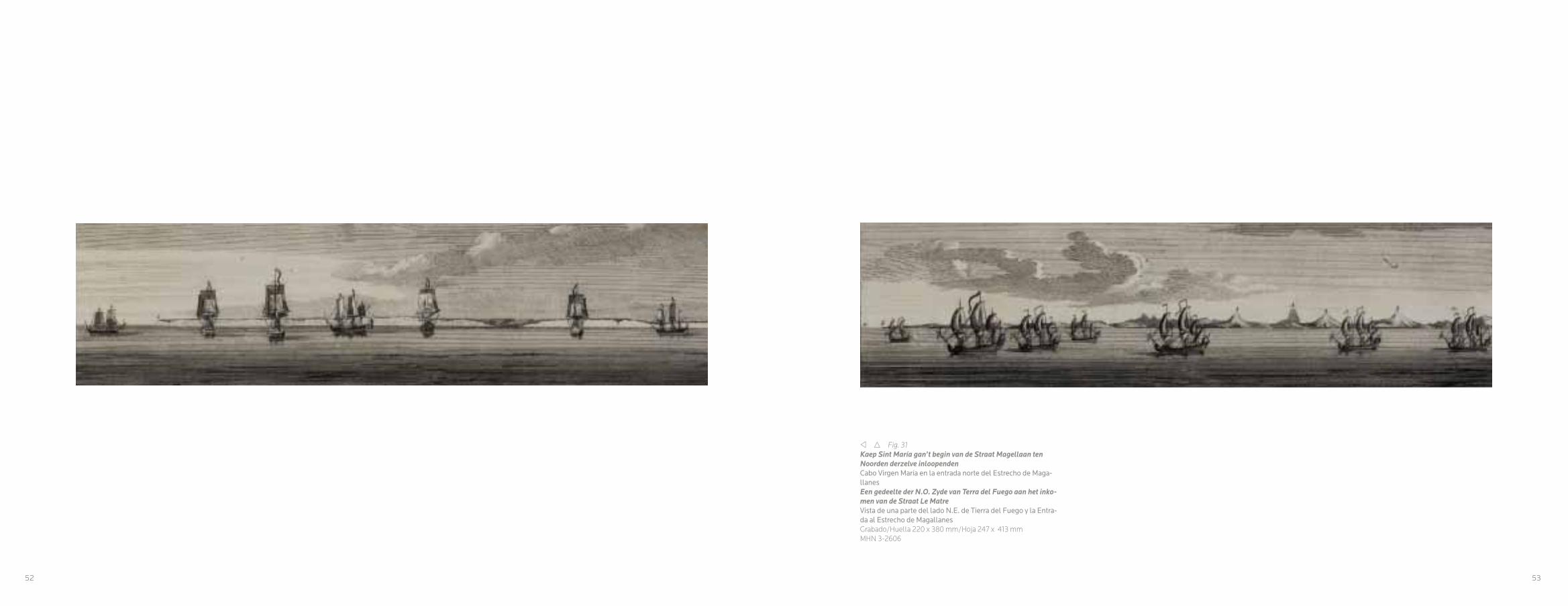
v r Fig. 31Kaep Sint María gan’t begin van de Straat Magellaan ten Noorden derzelve inloopendenCabo Virgen María en la entrada norte del Estrecho de Maga-llanesEen gedeelte der N.O. Zyde van Terra del Fuego aan het inko-men van de Straat Le Matre Vista de una parte del lado N.E. de Tierra del Fuego y la Entra-da al Estrecho de MagallanesGrabado/Huella 220 x 380 mm/Hoja 247 x 413 mmMHN 3-2606
52 53
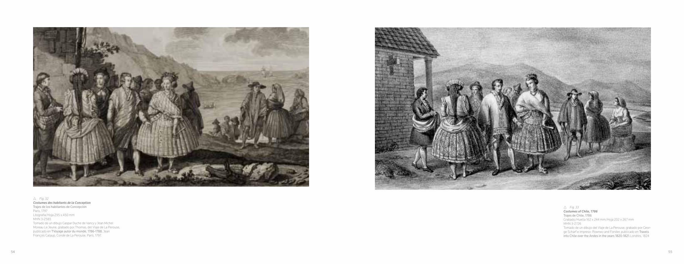
r Fig. 32Costumes des habitants de la ConceptionTrajes de los habitantes de ConcepciónParis, 1797Litografía/Hoja 295 x 450 mmMHN 3-2585Tomado de un dibujo Gaspar Duche de Vancy y Jean Michel Moreau Le Jeune, grabado por Thomas, del Viaje de La Perouse, publicado en TVoyage autor du monde, 1786-1788. Jean François Galaup, Conde de La Perouse, París, 1797.
r Fig. 33Costumes of Chile, 1786Trajes de Chile, 1786Grabado/Huella 162 x 244 mm/Hoja 202 x 267 mmMHN 3-2726Tomado de un dibujo del Viaje de La Perouse, grabado por Geor-ge Scharf e impreso: Rownwy and Forster, publicado en Travels into Chile over the Andes in the years 1820-1821.Londres, 1824
54 55
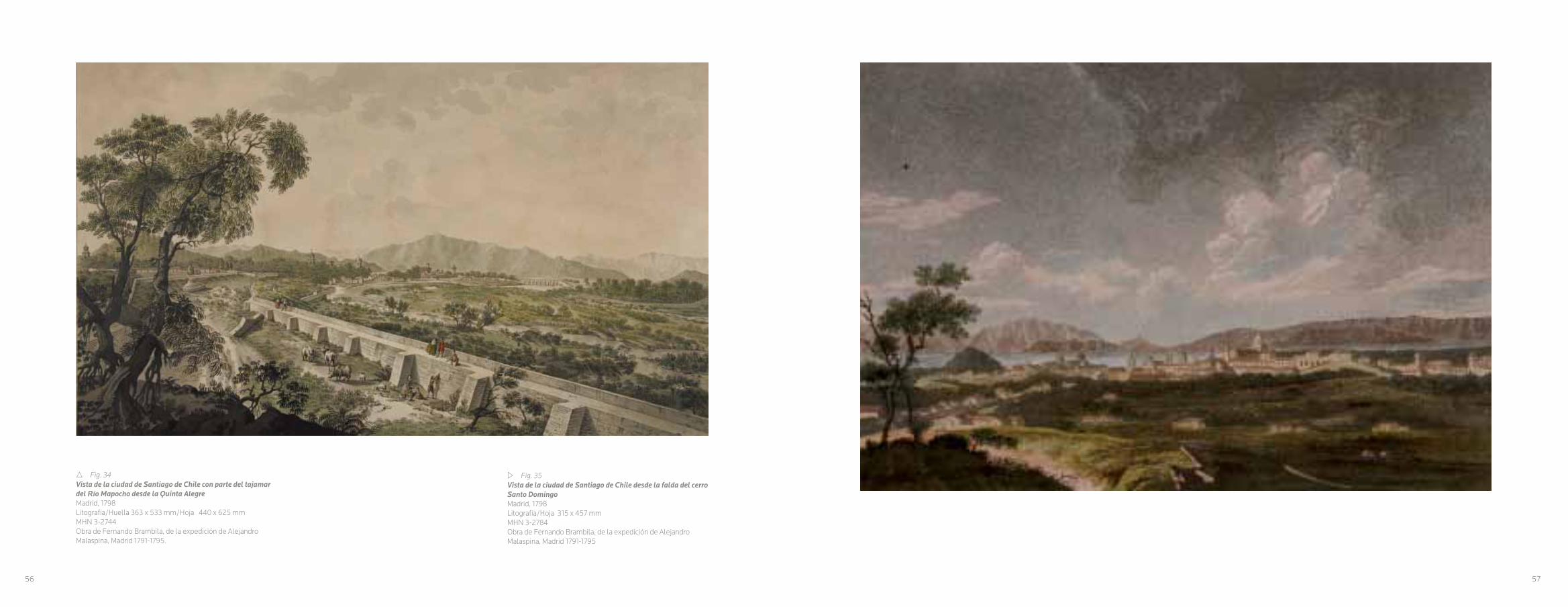
r Fig. 34Vista de la ciudad de Santiago de Chile con parte del tajamar del Río Mapocho desde la Quinta AlegreMadrid, 1798Litografía/Huella 363 x 533 mm/Hoja 440 x 625 mmMHN 3-2744Obra de Fernando Brambila, de la expedición de Alejandro Malaspina, Madrid 1791-1795.
w Fig. 35Vista de la ciudad de Santiago de Chile desde la falda del cerro Santo DomingoMadrid, 1798Litografía/Hoja 315 x 457 mmMHN 3-2784Obra de Fernando Brambila, de la expedición de Alejandro Malaspina, Madrid 1791-1795
56 57
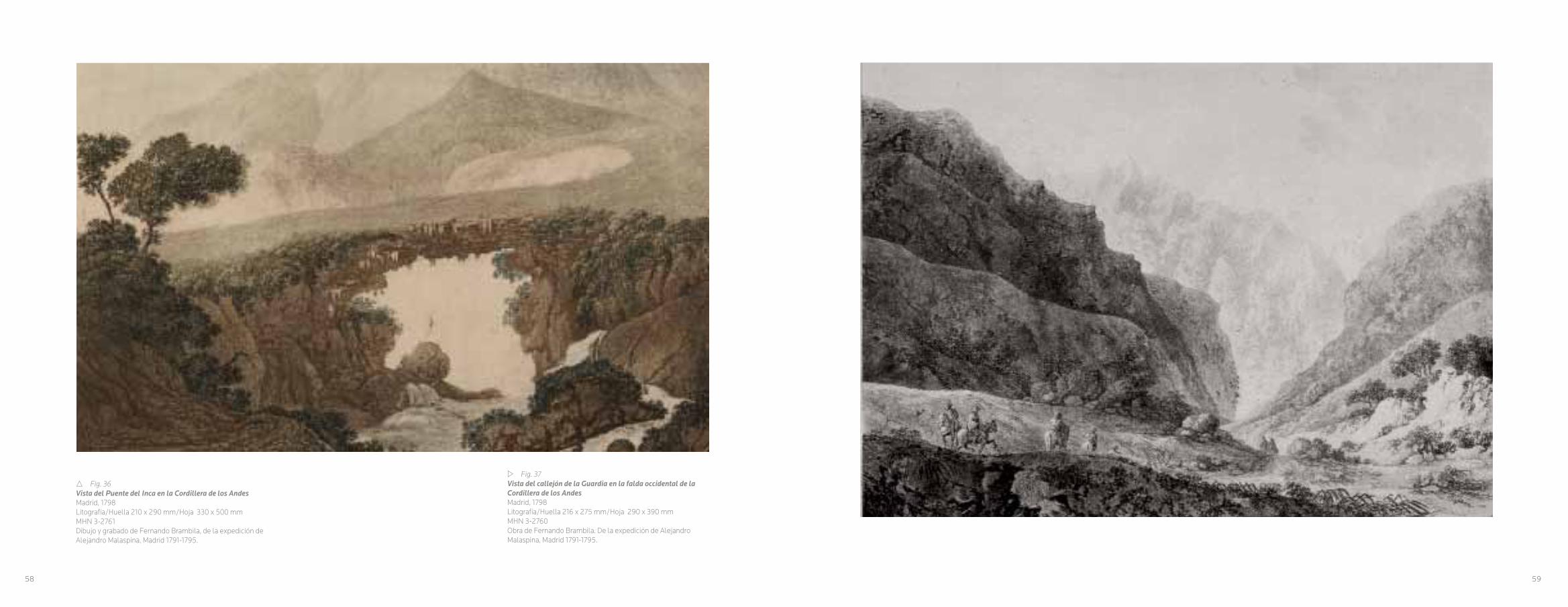
r Fig. 36Vista del Puente del Inca en la Cordillera de los AndesMadrid, 1798Litografía/Huella 210 x 290 mm/Hoja 330 x 500 mmMHN 3-2761Dibujo y grabado de Fernando Brambila, de la expedición de Alejandro Malaspina, Madrid 1791-1795.
w Fig. 37Vista del callejón de la Guardia en la falda occidental de la Cordillera de los AndesMadrid, 1798Litografía/Huella 216 x 275 mm/Hoja 290 x 390 mmMHN 3-2760Obra de Fernando Brambila. De la expedición de Alejandro Malaspina, Madrid 1791-1795.
58 59

w Fig. 38La casa de la cumbre en el camino principal de la Cordillera de los Andes/ 1984. Toesas sobre el nivel del marMadrid, 1798Litografía/Huella 213 x 294 mm/Hoja 328 x 390 mmMHN 3-2759Dibujo y grabado por Fernando Brambila, de la expedición de Alejandro Malaspina, Madrid 1791-1795
60 61

w Fig. 40Station entre la ladera cortadera et celle de Caule (Andes du Chili)Parada entre la ladera Cortadera y la de Caule (Andes de Chile)Paris, 1828 Litografía/Hoja 295 x 380 mmMHN 3-2771 Dibujo de Edmond Bigot de la Touanne, litografía a León Jean Baptiste Sabatier, figuras de Víctor Jean Adam e impreso por Benard y Frey en París, bajo la publicación Album Pittoresque de la fregate La Thetis et de la corvette L’Esperance. Baron Hyacinthe de Bougainville, París 1828.
r Fig. 39Vue de la ville de la Conception (Chili)Vista de la ciudad de La Concepción (Chile)París, 1822Litografía/Huella 209 x 262 mm/Hoja 284 x 349 mmMHN 3-2733Dibujo de Louis Choris, litografía de de Bode, e impreso bajo la dirección de Noel y Cía, publicado en Voyage Pittoresque autuor du monde avec de portrait de sauvages de Amerique. Otto von Kotzebue.París, 1822
62 63

w Fig. 42Rade de CobijaBahía de CobijaParis, 1841Litografía/Huella 248 x 336 mm/Hoja 337 x 570 mmMHN 3-2774Dibujo de Touchard, litografía de Louis Philippe Alphonse Biche-bois, figuras de Víctor Jean Adam e impreso por Lemercier,Benard y CiePublicado en Voyage autor du monde pendant les années 1836 a 1837 sur la corvette La Bonite, Nicolas Vaillant, Paris, 1841.
r Fig. 41Rade de CobijaBahía de CobijaParis, 1841Litografía/Huella 223 x 335 mm/Hoja 335 x 510 mmMHN 3-2773Dibujo Barthélemy Lauvergne, litografía de Louis Philippe Alphonse Bichebois e impreso por Lemercier. Publicado en Voyage autor du monde pendant les années 1836 a 1837 sur la corvette La Bonite, Nicolas Vaillant, Paris, 1841.
64 65

v Fig. 43Tajamar or Public WalkTajamar o paseo públicoLondres, 1824Grabado/Huella 163 x 248 mm/Hoja 198 x 268 mm.MHN 3-2718Dibujo de Peter Schmidtmeyer, grabado Agostino Aglio, impre-so por Rowney and Forster.
CAPITULO III
ITINERARIO DE LA MIRADA, LA DESCRIPCIÓN DE UN NUEVO TERRITORIO
Con la independencia de las nuevas
naciones americanas, se hizo presente una
gran escalada de expediciones europeas y
norteamericanas. En dichas incursiones venían
dibujantes, botánicos y científicos en general,
interesados por los temas geográficos de
rutas, mapas y cartas, como también la flora y
fauna americanas.28 Las imágenes del paisaje
y los habitantes, tomados desde un punto
de vista costumbrista, fueron muy populares
en Europa. Los dibujos eran traspasados a
grabados, los que se imprimían acompañando
los textos, mostrando a un público europeo
imágenes de las nuevas tierras. En este
contexto, se encuentran aquellas imágenes
publicadas en Into Chile over the Andes in the years 1820-1821, del viajero Peter
Schmidtmeyer, impreso por Rowney and
Forster en Londres, en 1824.
A Schmidtmeyer le correspondió junto a John
Miers, publicar en cada una de sus obras los
primeros planos de la ciudad de Santiago en
la época republicana, el de Schmidtmeyer se
publicó en 1824 y el de Miers en 1826. 29
La obra de Peter Schmidtmeyer, es interesante
en cuanto a registro visual, pero mantiene una
estructura convencional en la representación,
lo que se puede apreciar en las imágenes que
acompañan el libro que relata su expedición,
como son el cruce de los Andes o las vistas de
Santiago; sus paseos o edificios emblemáticos,
donde aparecen, junto con el paisaje, los
diferentes tipos humanos que representaban a
la variedad de grupos sociales que integraba
esta nueva nación americana. Todo lo cual,
para el mundo europeo no hispánico, eran
prácticamente desconocidos. (Fig. 43)
Schmidtmeyer, convocó a grabadores
importantes en la escena británica de los
primeros decenios del siglo XIX, uno de ellos
fue Agostino Aglio, (1777-1857) quien fue
pintor, grabador y decorador, de origen italiano,
formado en la Academia de Milán y que en 1803
llegó a Inglaterra para asistir a la publicación de
Antiquities Magna Gracvia, del arquitecto William
Wilkins, publicada en 1807. También utilizó
los dibujos de Juan Diego Paroissien, cuyo
nombre era James Paroissien (1781-1827),
médico inglés que participó en las guerras de
la independencia de Chile y Perú. Cuyo dibujo
de la Casa de Moneda de Santiago fue grabado
por George Scharf (1788-1860), ilustrador y
grabador alemán, especialista litográfico, quien
trabajó en Londres en ilustraciones de edificios
y de la vida cotidiana inglesa. (Fig. 44)
66 67

En el caso de John Miers (1789-1879), éste fue
un botánico e ingeniero británico que exploró
y trabajó en América del Sur entre los años
1819 a 1838. En 1825 volvió a Inglaterra para
publicar su relato en Travel in Chile and La Plata,
donde se da cuenta de especies botánicas no
conocidas en Europa, como también una de las
primeras imágenes del Santiago republicano.
Plaza or great Square of Santiago with different national costumes, representa una imagen de la
Plaza de Armas de Santiago, en ese entonces
llamada de la Independencia. En el grabado
se aprecian los edificios más emblemáticos de
la ciudad; la Casa del Presidente, el Palacio
de la Independencia (edificio que hoy alberga
al Museo Histórico Nacional) y el Cabildo. En
este caso, el dibujo fue de John Miers, y la
litografía de Thomas Mann Baynes (1794–1876)
acuarelista y grabador inglés, especializado
en vistas de edificios y paisajes, e impreso en
Londres por Hullmandel en 1826. (Fig. 45)
De este período, existe un número importante
de imágenes anónimas, una de ellas, es una
acuarela que grafica un puente, calificado de
indígena, sobre el río Maipo, con fecha de
1821, (Fig. 46) probablemente fue hecho por
un viajero norteamericano o inglés, quien en el
reverso describe el dibujo y el año en que fue
realizado, una acuarela descriptiva, donde se
refuerza lo agreste del territorio. Un puente que
no dejó de llamar la atención a Charles Darwin,
quien en septiembre de 1834, daba cuenta:
Llegamos a eso del mediodía a uno de los puentes colgantes hechos con pieles, puentes que atraviesan el río Maipo de caudalosa corriente rápida, que discurre a algunas leguas al sur de Santiago. ¡Triste cosa son esos puentes! El tablero o piso, que se presta a todos los movimientos de las cuerdas que lo sostienen, consiste en trozos de madera colocados unos al lado de los otros…30
Otro aspecto interesante que recogieron
los primeros exploradores científicos en
Chile, fueron los efectos de los terremotos,
especialmente en las áreas urbanas. Las
imágenes de las ruinas de Valparaíso y de
Concepción son elocuentes, en especial en el
contexto que estas fueron dirigidas a un público
europeo, quien no tenía una noción de estas
catástrofes naturales. El grabado de Stanislas
Marie César Famin (1799 – 1853) con el
terremoto de Valparaíso de 1822 (Fig. 47) o las
imágenes de la expedición de exploración de
Jules Sébastian César Dumont d’Urville (1790-
1842), trasuntan cierto exotismo. Lo mismo
ocurre con las imágenes donde aparecen las
chozas en la playa de Talcahuano y las ruinas
de la iglesia de Santo Domingo en Concepción
y otra litografía mostrando las ruinas de una
iglesia en la misma ciudad. (Figs. 48,49)
Las imágenes de los puertos fueron también
un tema explotado y recurrente. Era necesaria
su representación en el contexto de la febril
actividad comercial que dinamizaba las
w Fig. 44The Mint of SantiagoLa Casa de Moneda de SantiagoLondres, 1824Grabado/Huella 160 x 245 mm/Hoja 175 x 252 mmDibujado por Juan Diego Parossien, grabado por George Scharf e impreso por Rowney and ForsterMHN 3-2708
rutas navieras, eran puntos de contacto y se
necesitaba conocer su morfología urbana y
sus adelantos portuarios. Vistas de Valparaíso
y Talcahuano fueron ampliamente descritas
en diferentes imágenes para grabados que
ilustraban los libros de viajes. (Figs. 50, 51, 52).
Son representaciones más objetivas que las
imágenes del interior del país, que en algunos
casos, como son en las ilustraciones de Cesar
Famin, desarrollaron un exotismo que no
correspondía a la tipología del paisaje local.
(Figs. 53, 54). A diferencia de las visiones
exóticas de Famin, nos encontramos con las
representaciones realizadas para la expedición
de Jules Sébastian César Dumont d’Urville. Las
naves de su expedición, la Zelée y Astrolabe,
navegaron por el Estrecho de Magallanes hacia
1837, entregando imágenes inéditas de la
geografía austral de Chile, con una naturaleza
remota, que no impidió la representación
detallada del medio natural, con un estilo
pictórico. (Fig. 55).
68 69

Las imágenes del sur de Chile, no estuvieron
ausentes. Los dibujos de Rodulfo Philippi son
notables a la hora de mostrar un territorio en
explotación como era el de Valdivia. (Fig.56) En la segunda mitad del siglo XIX, otra
imagen muestra un paisaje que se aleja de
lo exuberante y no dominado por el hombre,
en ellos se ve campos agrícolas mostrando
progreso. (Fig.57).
Fue común el tema de las vistas de las
ciudades, tanto de Valparaíso mostrando su
bahía, como de Santiago. Un ejemplo de ello es
el caso de José Selleny, artista de la expedición
austriaca que vino en la fragata Novara en
1859. (Fig.58). Los dibujos y acuarelas de la
Plaza de la Independencia en Santiago y de
la vista de Valparaíso de ese año, muestran
la ciudad siguiendo el tema de la veduta,
con perspectivas áreas, dando cuenta de los
detalles urbanos. (Figs. 59, 60). A esto se suma
la obra Valparaíso desde el cerro Concepción,
obra anónima cercana a 1860. (Fig. 61).
En esta línea, a partir del siglo XVIII, en el
ámbito del género pictórico del paisaje se
aplicó la veduta, desarrollado principalmente
en la ciudad de Venecia, consistente en
vistas urbanas, basadas en la perspectiva
y con una mirada panorámica, pero de la
misma forma con descripciones minuciosas.
Ya en el siglo XVI, los grabadores
flamencos habían desarrollado la impresión
de imágenes aéreas de ciudades o
levantamientos con perspectivas. En el caso
de Chile, las vistas fueron desarrolladas
por viajeros, como una suerte de postal
panorámica. Esta práctica estaba enmarcada
en un acercamiento científico al paisaje,
por su descripción informada y detallada.
Para ello se utilizaron instrumentos que
posibilitaran la representación fiel de la
naturaleza, como fue la cámara oscura y
posteriormente la fotografía.
Uno de los primeros ejemplos de esta técnica,
fue lo realizado en cinco litografías por
Agostino Aglio, según el dibujo de William
Waldegrave (1796-1838). Realizadas en 1821
cuando Waldegrave, marino inglés, estuvo
en Santiago. Es una vista en 360 grados, las
que se publicaron como A series of panoramic views of Sant Jago, the capital of Chili, editadas
en Londres por John Boosey en 1823. Es un
documento extraordinario para la historia urbana
de Santiago, ya que con precisión y con gran
calidad artística se muestra la ciudad. (Fig. 62)
En el contexto de la expedición norteamericana
Astronómica en el Hemisferio Sur, en 1849,
a cargo del teniente James Melville Gilliss
(1811-1865), vino a Chile Edmond Reuel Smith
(1829-1911), quien fuera parte del equipo
de la expedición de Gilliss, trabajando con él
en la medición astronómica y recolección de
especímenes y datos. Smith vivió en Santiago
desde 1849 hasta 1852, lapso de tiempo donde
realizó los dibujos en base a un daguerrotipo
de una vista de Santiago en 360 grados, desde
el cerro Santa Lucía, la que se denominó
Panoramic View From Summit of Santa Lucia, Santiago. Publicada en Washington en 1855,31
la litografía de la imagen corresponde a Thomas
S. Sinclaire (1805-1881). Al igual que la obra
de Waldegrave, la obra de Smith entrega una
valiosa información sobre el estado de la urbe a
mediados del siglo XIX.32 (Fig. 63)
En 1863, T.H. Harvey realizó una vista
panorámica de 180 grados, a partir del cerro
Santa Lucía, con un especial detalle en las
construcciones cercanas al cerro, una vista que
sigue la temática de las dos anteriores, en esta
última con detalles pictóricos. (Fig. 64)
v Fig. 45Plaza or great Square of Santiago with different national costumesGran plaza de Santiago con diferentes trajes nacionalesLondres, 1826Litografía/Huella 154 x 337 mm/Hoja 221 x 375 mmMHN 3-2739Dibujo de John Miers, litografía de Thomas Mann Baynes e impreso por Hullmandel.
70 71

CHAPTER III
ITINERARY OF A PERSPECTIVE, THE DESCRIPTION OF A NEW TERRITORY
With the independence of the new American nations, a large number of European and North American expeditions arrived. These incursions included draftsmen, botanists and scientists, interested in geographic issues of routes, maps and charts, as well as South American flora and fauna.28 Images of landscapes and their inhabitants from a costumbrista perspective were very popular in Europe. The drawings were made into engravings, which were then printed to complement the texts, exposing the European public to images of the new lands. It was in this context that in 1824, traveler Peter Schmidtmeyer’s images were published in Into Chile over the Andes in the years 1820-1821, printed by Rowney and Forster, London.
Schmidtmeyer, and later John Miers published, in their respective works, the first maps of the city of Santiago during the Republican period. Schmidtmeyer’s was published in 1824 and Miers’ followed in 1826.29
The work by Peter Schmidtmeyer is inte-resting as a visual record, but its representation follows a conventional
structure, as can be observed in the illustrations in the book relating his expedition, such as the crossing of the Andes or the scenes of Santiago. The prints of the city document its esplanades and emblematic buildings, which appear alongside the landscape and different types of human figures that represent the diverse social groups that were part of this new American nation. All this was practically unknown to the non-Hispanic European world. (Fig. 43)
Schmidtmeyer brought together important English engravers from the first decades of the 19th century, one of whom was Agostino Aglio, (1777-1857) a painter, engraver and decorator, born in Italy and trained in the Academy of Milan who arrived in England in 1803 to assist with the publication of Antiquities Magna Gracvia by the architect William Wilkins in 1807. He also used the drawings of Juan Diego Paroissien, whose original name was James Paroissien, (1781-1827), an English physician who took part in the wars of Chilean and Peruvian independence. His drawing of the Casa de Moneda in Santiago was engraved by George Scharf (1788-1860), a German illustrator, engraver and lithographer who worked in London on illustrations of buildings and everyday English life. (Fig. 44)
John Miers (1789-1879) was an English botanist and engineer who explored and
w Fig. 46Puente indígena sobre el río Maipo, ChileAnónimo1821Tinta y acuarela sobre papel/114 x 188 mmMHN 3-1606
72 73
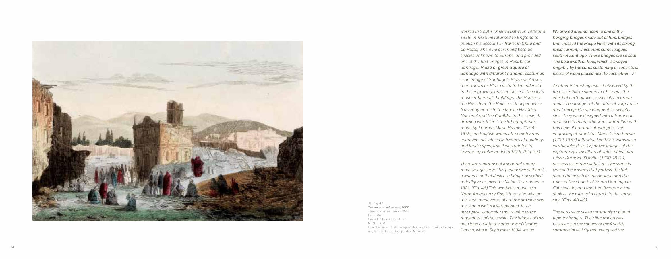
worked in South America between 1819 and 1838. In 1825 he returned to England to publish his account in Travel in Chile and La Plata, where he described botanic species unknown to Europe, and provided one of the first images of Republican Santiago. Plaza or great Square of Santiago with different national costumes is an image of Santiago’s Plaza de Armas, then known as Plaza de la Independencia. In the engraving, one can observe the city’s most emblematic buildings: the House of the President, the Palace of Independence (currently home to the Museo Histórico Nacional and the Cabildo. In this case, the drawing was Miers’, the lithograph was made by Thomas Mann Baynes (1794–1876), an English watercolor painter and engraver specialized in images of buildings and landscapes, and it was printed in London by Hullmandel in 1826. (Fig. 45)
There are a number of important anony-mous images from this period; one of them is a watercolor that depicts a bridge, described as indigenous, over the Maipo River, dated to 1821. (Fig. 46) This was likely made by a North American or English traveler, who on the verso made notes about the drawing and the year in which it was painted. It is a descriptive watercolor that reinforces the ruggedness of the terrain. The bridges of this area later caught the attention of Charles Darwin, who in September 1834, wrote:
We arrived around noon to one of the hanging bridges made out of furs, bridges that crossed the Maipo River with its strong, rapid current, which runs some leagues south of Santiago. These bridges are so sad! The boardwalk or floor, which is swayed mightily by the cords sustaining it, consists of pieces of wood placed next to each other …30
Another interesting aspect observed by the first scientific explorers in Chile was the effect of earthquakes, especially in urban areas. The images of the ruins of Valparaíso and Concepción are eloquent, especially since they were designed with a European audience in mind, who were unfamiliar with this type of natural catastrophe. The engraving of Stanislas Marie César Famin (1799-1853) following the 1822 Valparaíso earthquake (Fig. 47) or the images of the exploratory expedition of Jules Sébastian César Dumont d’Urville (1790-1842), possess a certain exoticism. The same is true of the images that portray the huts along the beach in Talcahuano and the ruins of the church of Santo Domingo in Concepción, and another lithograph that depicts the ruins of a church in the same city. (Figs. 48,49)
The ports were also a commonly explored topic for images. Their illustration was necessary in the context of the feverish commercial activity that energized the
v Fig. 47Terremoto a Valparaíso, 1822Terremoto en Valparaíso, 1822Paris. 1840Grabado/Hoja 140 x 213 mmMHN 3-2618César Famin, en Chili, Paraguay, Uruguay, Buenos Aires, Patago-nie, Terre du Feu et Archipel des Malouines.
74 75

w Fig. 48Casses sur la plage de Talcahuano (Chili)Chozas en la playa de Talcahuano (Chile)Ruines de l ‘Eglise de Santo Domingo a Concepción(Chili)Ruinas de la iglesia de Santo Domingo en Concepción (Chile)París, 1846Litografía /Huella 290 x 265 mm/Hoja 440 x 385 mmMHN 3-2765Dibujo de Louis Lebreton, grabado por Delaplante, impreso por Lemercier.
shipping routes. These places were contact points and it was important to understand their urban morphology and port developments. Scenes of Valparaíso and Talcahuano were pictured often in engravings that illustrated travel books. (Figs. 50, 51, 52 )
These representations are more objective than the images from the interior of the country, which, in some cases, such as the illustrations by Cesar Famin, developed an exoticism that did not correspond to the typology of the local landscape. (Fig. 53, 54) Departing from the exotic visions of Famin, we may observe the representations made for the expedition of Jules Sébastian César Dumont d’Urville. The ships of this expedition, Zelée and Astrolabe, navigated through the Straights of Magellan circa 1837, providing unprecedented images of Chile’s Patagonian geography, which although alien and remote, did not prevent the detailed illustration of the natural scenery with a pictorial style. (Fig. 55)
Images of Chile’s near south were also made. The drawings of Rodulfo Philippi are noteworthy examples that portray the exploitation of terrain, such as that of Valdivia. (Fig. 56) In the second half of the 19th century, another image shows a landscape that is far removed from the exuberant and the untamed, capturing
agricultural fields and demonstrating the progress in the area. (Fig. 57)
The theme of city views was very common, both of Valparaíso, showing its bay, and of Santiago. José Selleny, an artist with the Austrian expedition that arrived on the frigate Novara in 1859, produced pictures in this vein. (Fig. 58) His drawings and watercolors of the Plaza de la Independencia in Santiago, as well as his view of Valparaíso from the same year, show the cities following the veduta style, with perspectives showing off the urban details. (Figs. 59, 60) Similar images include Valparaíso desde el cerro Concepción, an anonymous work circa 1860. (Fig. 61)
Beginning in the 18th century, the pictorial landscape genre began to employ the veduta, a style developed in the city of Venice, which consisted of urban scenes based on perspective and a panoramic gaze, also including highly descriptive details. Already in the 16th century, Flemish engravers had been developing the printing of aerial images of cities and drafting with perspective. In Chile, these images were developed by travelers as a kind of panoramic postcard. This practice was framed as a scientific approach to landscape, attempting to describe it with detailed information. This process used instruments that made it possible to produce a faithful representation of nature, such as the camera obscura and later photography.
One of the first examples of this technique can be observed in five lithographs by Agostino Aglio, based on the drawings of William Waldegrave (1796-1838). Created in 1821, when Waldegrave, an English sailor, was in Santiago, together they produce a 360-degree view of the city that was published as A series of panoramic views of Sant Jago, the capital of Chili, edited in London by John Boosey in 1823. It is an extraordinary document for the urban history of Santiago, since it depicts the city with great precision and high artistic quality. (Fig. 62)
As part of the team led by Lieutenant James Melville Gilliss (1811-1865) on a North American astronomical expedition in the southern hemisphere in 1849, Edmond Reuel Smith (1829-1911) came to Chile, taking astronomical measurements and collecting specimens and data. Smith lived in Santiago from 1849 to 1852, during which time he produced drawings based on a daguerreotype of a 360-degree view of Santiago as seen from Santa Lucía Hill, which he called Panoramic View from Summit of Santa Lucia, Santiago. Published in Washington D.C. in 1855,31 the lithograph of this image was made by Thomas S. Sinclaire (1805-1881). Like the work by Waldegrave, Smith’s work provides valuable information on the state of the city during the mid-1900s.32 (Fig. 63)
In 1863, T. H Harvey produced a 180-degree panoramic view, beginning at Santa Lucía Hill, with special attention paid to the constructions nearby, an image that continues the theme of the previous two, but with great pictorial detail. (Fig. 64)
76 77

r Fig. 49Ruines d’ une eglise a Concepcion (Chili)Ruinas de una iglesia en Concepción (Chile)París, 1846Litografía/Hoja 303 x 437 mmMHN 3-2766Dibujo de Ernest Auguste Goupil, grabado de Henri Pharaond Blanchard e impreso por Tierry fréres
r Fig. 50ValparaísoParis. 1840Grabado/Hoja 141 x 215 mmMHN 3-2619César Famin, Chili, Paraguay, Uruguay, Buenos Aires, Patago-nie, Terre du Feu et Archipel des Malouines.
78 79

r Fig. 51Rade de ValparaísoBahía de ValparaísoParis. 1840Grabado/Hoja 126 x 202 mmMHN 3-2617Dibujo de Petit, grabado de Samuel Jean Joseph Cholet, en Ce-sar Famin, Chili, Paraguay, Uruguay, Buenos Aires, Patagonie, Terre du Feu et Archipel des Malouines.
w Fig. 52Vue de Talcahuano de ChiliVista de Talcahuano de ChileLitografía/Hoja 176 x 265 mmMHN 3-36891
80 81

r Fig.53Passage du rio QuillotaPaso del río QuillotaParis. 1840Grabado/Hoja 125 x 170 mmMHN 3-36086
w Fig. 54Vista del río TorbidoParis. 1840Grabado/Hoja 118 x 160 mmMHN 3-36088Dibujo de Alex, en César Famin, Chili, Paraguay, Uruguay, Bue-nos Aires, Patagonie, Terre du Feu et Archipel des Malouines.
82 83

r Fig. 55Etablissement des Baleiniers sur l’ile Quiriquina (Chili)Establecimiento ballenero en la Isla Quiriquina (Chili)París, 1846Litografía/Huella 244 x 375 mm/Hoja 336 x 490 mmMHN 3-2764Dibujo de Louis Lebreton y figuras de navíos de Mayer, litografía de León Baptiste Sabatier e impreso por Lemercier.
r Fig. 56El molino de San Juan, ValdiviaRodulfo PhilippiGrafito sobre papel/114 x 188 mmMHN 3-1606
84 85
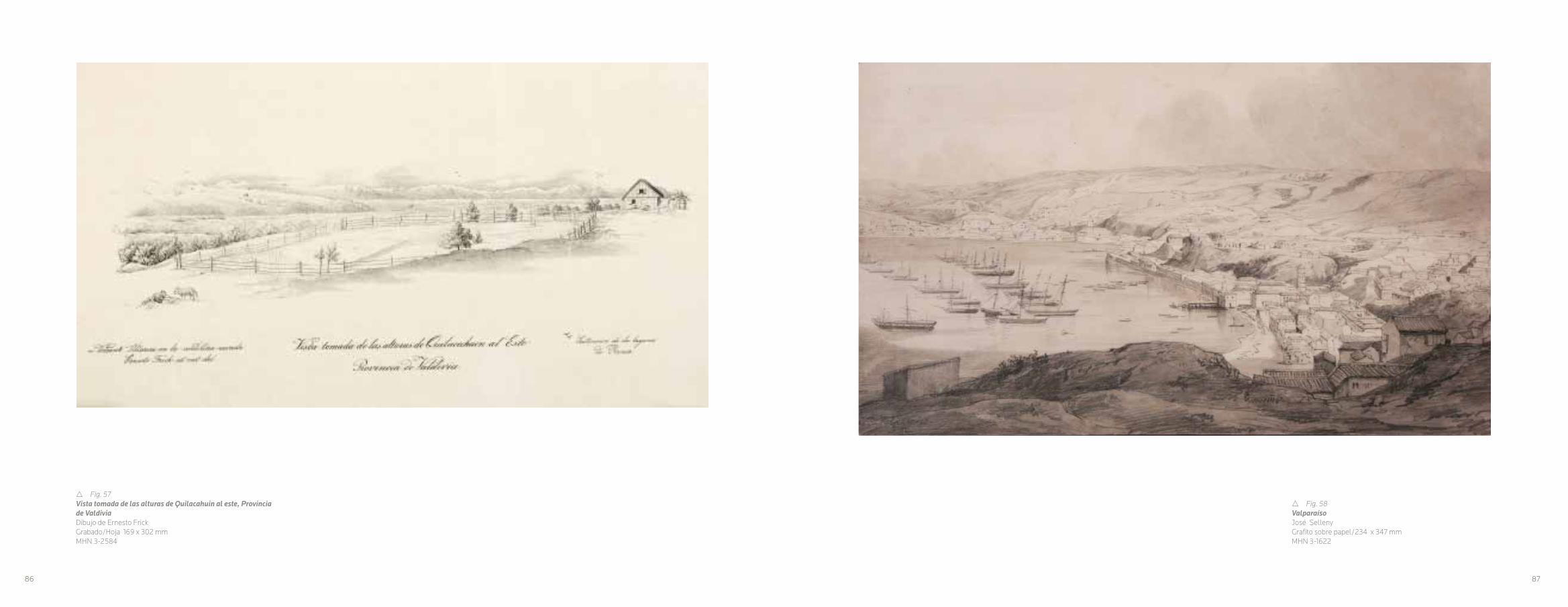
r Fig. 57Vista tomada de las alturas de Quilacahuin al este, Provincia de ValdiviaDibujo de Ernesto FrickGrabado/Hoja 169 x 302 mmMHN 3-2584
r Fig. 58ValparaísoJosé SellenyGrafito sobre papel/234 x 347 mmMHN 3-1622
86 87
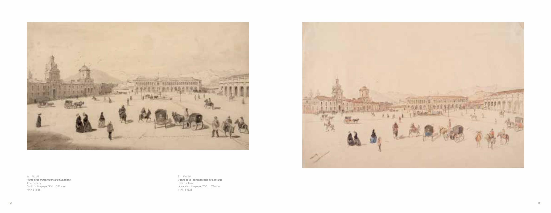
w Fig. 60Plaza de la Independencia de SantiagoJosé SellenyAcuarela sobre papel/350 x 510 mmMHN 3-1623
r Fig. 59Plaza de la Independencia de SantiagoJosé SellenyGrafito sobre papel/234 x 346 mmMHN 3-1565
88 89
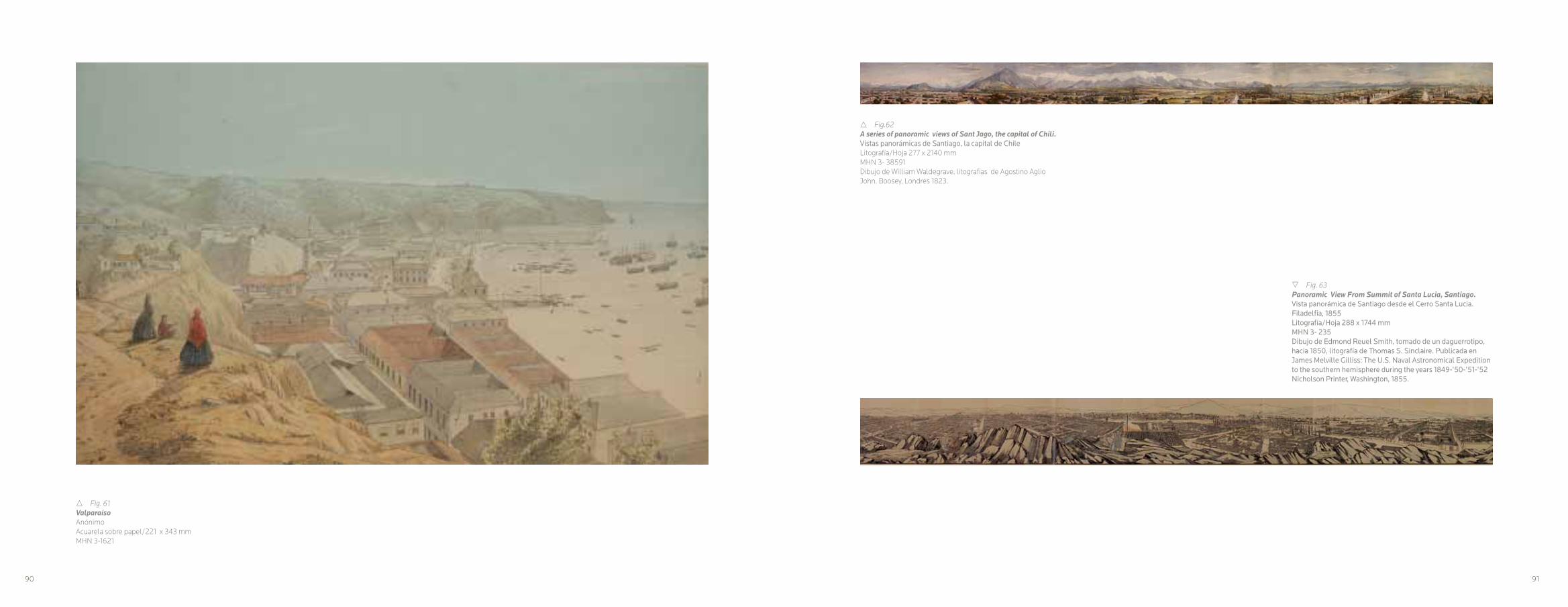
r Fig. 61ValparaísoAnónimoAcuarela sobre papel/221 x 343 mmMHN 3-1621
r Fig.62A series of panoramic views of Sant Jago, the capital of Chili.Vistas panorámicas de Santiago, la capital de ChileLitografía/Hoja 277 x 2140 mmMHN 3- 38591Dibujo de William Waldegrave, litografías de Agostino Aglio John. Boosey, Londres 1823.
s Fig. 63Panoramic View From Summit of Santa Lucia, Santiago.Vista panorámica de Santiago desde el Cerro Santa Lucia.Filadelfia, 1855Litografía/Hoja 288 x 1744 mmMHN 3- 235Dibujo de Edmond Reuel Smith, tomado de un daguerrotipo, hacia 1850, litografía de Thomas S. Sinclaire. Publicada en James Melville Gilliss: The U.S. Naval Astronomical Expedition to the southern hemisphere during the years 1849-’50-’51-’52 Nicholson Printer, Washington, 1855.
90 91

r Fig. 64Vista general de Santiago.Harvey T.H.1863Litografía/Técnica mixta/Hoja 450 x 1850 mmMHN 3-29894
92 93
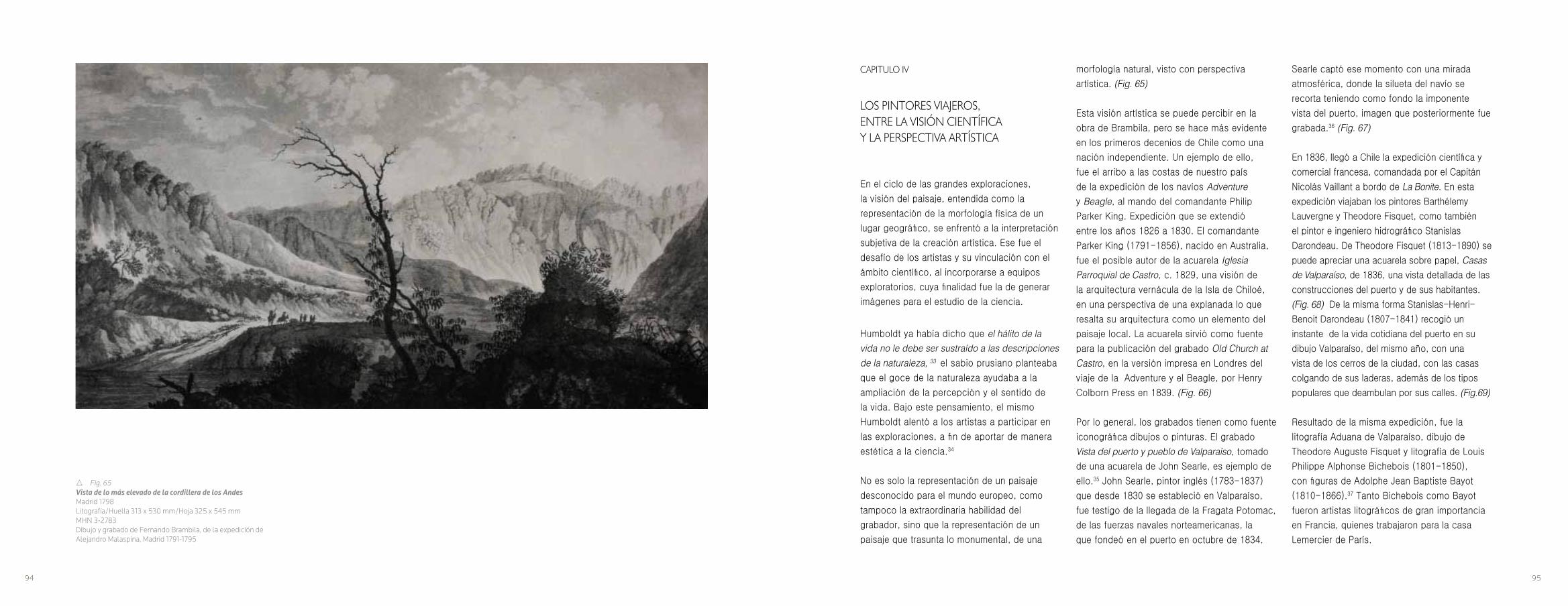
r Fig. 65Vista de lo más elevado de la cordillera de los AndesMadrid 1798Litografía/Huella 313 x 530 mm/Hoja 325 x 545 mmMHN 3-2783Dibujo y grabado de Fernando Brambila, de la expedición de Alejandro Malaspina, Madrid 1791-1795
CAPITULO IV
LOS PINTORES VIAJEROS, ENTRE LA VISIÓN CIENTÍFICA Y LA PERSPECTIVA ARTÍSTICA
En el ciclo de las grandes exploraciones,
la visión del paisaje, entendida como la
representación de la morfología física de un
lugar geográfico, se enfrentó a la interpretación
subjetiva de la creación artística. Ese fue el
desafío de los artistas y su vinculación con el
ámbito científico, al incorporarse a equipos
exploratorios, cuya finalidad fue la de generar
imágenes para el estudio de la ciencia.
Humboldt ya había dicho que el hálito de la vida no le debe ser sustraído a las descripciones de la naturaleza, 33 el sabio prusiano planteaba
que el goce de la naturaleza ayudaba a la
ampliación de la percepción y el sentido de
la vida. Bajo este pensamiento, el mismo
Humboldt alentó a los artistas a participar en
las exploraciones, a fin de aportar de manera
estética a la ciencia.34
No es solo la representación de un paisaje
desconocido para el mundo europeo, como
tampoco la extraordinaria habilidad del
grabador, sino que la representación de un
paisaje que trasunta lo monumental, de una
morfología natural, visto con perspectiva
artística. (Fig. 65)
Esta visión artística se puede percibir en la
obra de Brambila, pero se hace más evidente
en los primeros decenios de Chile como una
nación independiente. Un ejemplo de ello,
fue el arribo a las costas de nuestro país
de la expedición de los navíos Adventure y Beagle, al mando del comandante Philip
Parker King. Expedición que se extendió
entre los años 1826 a 1830. El comandante
Parker King (1791-1856), nacido en Australia,
fue el posible autor de la acuarela Iglesia Parroquial de Castro, c. 1829, una visión de
la arquitectura vernácula de la Isla de Chiloé,
en una perspectiva de una explanada lo que
resalta su arquitectura como un elemento del
paisaje local. La acuarela sirvió como fuente
para la publicación del grabado Old Church at Castro, en la versión impresa en Londres del
viaje de la Adventure y el Beagle, por Henry
Colborn Press en 1839. (Fig. 66)
Por lo general, los grabados tienen como fuente
iconográfica dibujos o pinturas. El grabado
Vista del puerto y pueblo de Valparaíso, tomado
de una acuarela de John Searle, es ejemplo de
ello.35 John Searle, pintor inglés (1783-1837)
que desde 1830 se estableció en Valparaíso,
fue testigo de la llegada de la Fragata Potomac,
de las fuerzas navales norteamericanas, la
que fondeó en el puerto en octubre de 1834.
Searle captó ese momento con una mirada
atmosférica, donde la silueta del navío se
recorta teniendo como fondo la imponente
vista del puerto, imagen que posteriormente fue
grabada.36 (Fig. 67)
En 1836, llegó a Chile la expedición científica y
comercial francesa, comandada por el Capitán
Nicolás Vaillant a bordo de La Bonite. En esta
expedición viajaban los pintores Barthélemy
Lauvergne y Theodore Fisquet, como también
el pintor e ingeniero hidrográfico Stanislas
Darondeau. De Theodore Fisquet (1813-1890) se
puede apreciar una acuarela sobre papel, Casas de Valparaíso, de 1836, una vista detallada de las
construcciones del puerto y de sus habitantes.
(Fig. 68) De la misma forma Stanislas-Henri-
Benoit Darondeau (1807-1841) recogió un
instante de la vida cotidiana del puerto en su
dibujo Valparaíso, del mismo año, con una
vista de los cerros de la ciudad, con las casas
colgando de sus laderas, además de los tipos
populares que deambulan por sus calles. (Fig.69)
Resultado de la misma expedición, fue la
litografía Aduana de Valparaíso, dibujo de
Theodore Auguste Fisquet y litografía de Louis
Philippe Alphonse Bichebois (1801-1850),
con figuras de Adolphe Jean Baptiste Bayot
(1810-1866).37 Tanto Bichebois como Bayot
fueron artistas litográficos de gran importancia
en Francia, quienes trabajaron para la casa
Lemercier de París.
94 95

La litografía de Fisquet muestra en un primer
plano personajes del puerto en sus actividades
y atrás el edificio de la aduana, como telón
de fondo, los cerros y sus construcciones.
Esta representación es una convención, ya
que en una misma imagen se trata de mostrar
varios aspectos. Según la especificación
de la litografía, tanto el edificio como el
paisaje fueron realizados por Fisquet, los
personajes fueron obra de Bayot, por lo
que nos encontramos con un caso de una
obra colectiva, en función de producir una
representación. (Fig.70)
Fisquet y Lauvergne fueron artistas que
formaron parte de las expediciones científicas.
Todos estos artistas, pintores, dibujantes,
bocetistas y grabadores, o artistas aficionados
como se denominaban, se alejan ciertamente,
del sentido que daban a sus obras los pintores
más tradicionales, en términos del concepto
de obra de arte. Los artistas viajeros, que eran
empleados para tales fines, debían darle a sus
representaciones la fidelidad de la naturaleza y
un carácter científico a sus obras, en el sentido
más estricto, sin tener sus trabajos un carácter
de creación artística, ya que debían ajustarse a
las convenciones establecidas.
En este sentido, lo primordial en estos artistas,
fue que sus realizaciones no tenían un fin
de obra de arte, sino de representaciones
científicas del paisaje, donde flora, fauna y
habitantes de los países visitados, están en
sus obras, solo al servicio de publicaciones
de crónicas de viajes y como textos visuales
de estas crónicas exploratorias. Éstas
estaban a cargo de las casas editoriales o
las imprentas. Una de las más importantes a
nivel internacional, fue la que fundó Joseph
Lemercier, quien abrió su imprenta en 1836 en
París. En un reportaje del Semanario Pintoresco
Español de 1851, se describía así el trabajo en
dicha imprenta:
Ocupa a ciento cuarenta operarios, cuyo jornal diario asciende respecto a los impresores desde cinco a quince francos, y en cuanto a los demás, de tres a cuatro. Se encuentra en movimiento incesante noventa prensas de brazo, en las cuales se tiran anualmente más de dos millones de láminas, tanto para cuadros como para libros de exportaciones.38
Sin embargo, desde la invención de la litografía
por el alemán Alois Senefelder en 1789, y su
masiva utilización en el segundo decenio del siglo
XIX, esta técnica se acomodó a los requerimientos
pictóricos de los artistas, que vieron en ella
la posibilidad de masificar sus obras. En este
aspecto, la litografía encontró eco en varios
artistas viajeros, uno de ellos fue Borget.
André-Auguste Borget, fue un dibujante y
pintor francés (1808- 1877). Estudió arte
en París, discípulo de Boichard y del Barón
Jean Antoine Gudin. Participó en el ambiente
de la intelectualidad parisina de la época,
vinculándose con Balzac y George Sand.
Viajó por Asia y Oceanía. En América estuvo
en Nueva York, Rio de Janeiro y Montevideo.
Hacia 1837 se instaló en Buenos Aires, de
donde viajó a Chile, cruzando la cordillera.
En Santiago, estableció amistad con Mauricio
Rugendas, viviendo en el país hasta 1838.
Hacia 1845, en París, publicó el libro Fragment d’un Voyage Autour du Monde, en el que
incorporó una serie de litografías de sus viajes,
donde él mismo se encargó de realizar las
litografías. Una de ellas, Chilenos en descanso en el llano de Santiago, representa una síntesis
pictórica entre el grupo de huasos y el paisaje
y reflejó el aporte de los dibujos de Rugendas
sobre el valle de Santiago. Ambos trabajaron en
conjunto, siendo los que mejor tradujeron en un
lenguaje visual el paisaje de Chile. (Fig.71)
De las expediciones científicas y sus resultados
son especialmente interesantes los registros
visuales de Louis-Auguste De Sainson (1801-
1887). De Sainson, fue el artista oficial en la
expedición del L’Astrolabe, al mando de Dumont
D’Urville. Sus registros son meticulosos y con
muchos detalles, llenos de humor, como es el
caso de los de Robinson Crusoe. Sus grabados
en acero, abordan temáticas de paisaje, pero
básicamente entregan información ilustrativa al
respecto. Es el caso de la vista de la hacienda,
r Fig. 66Iglesia Parroquial de Castro, c. 1830 Philip Parker King (atribuido) Acuarela sobre papel/120 x 260 mmMHN 3-1691
96 97

v Fig. 67View of the Harbour and town of ValparaísoVista del puerto y pueblo de ValparaísoNueva York, 1835Grabado/Hoja 224 x 392 mmMHN 3-37221Tomado de una obra de John Searle, impreso por Harper & Brothers.
donde se resumen aspectos de información
cultural, o la fiesta popular. (Figs. 72, 73).
Como contrapunto a la información que
se entregaba, de manera convencional
se encuentran los dibujos de un autor
desconocido de la expedición de James
Melville Gilliss. Dibujos realizados hacia 1849,
mostrando las actividades rurales, las que no
solo muestran costumbres o la indumentaria
sino que se visualizan en contexto del paisaje.
(Figs. 74,75)
La consolidación de la República, determinó
que ya a mediados de siglo, desde el poder
político chileno, se planteara la necesidad
de realizar investigaciones sobre el país. Es
en este contexto que llegó desde Prusia,
Rudolf Amandus Philippi Krumwiede (1808-
1904). Nacido en Berlín, estudió medicina y
se dedicó a las Ciencias Naturales. En 1851
llegó a Chile huyendo de la persecución
política, recorriendo el territorio desde
el Desierto de Atacama, hasta el sur, en
Valdivia. Su mirada ciertamente científica, no
opacó en nada su sensibilidad artística, al
entregar importantes imágenes sobre varias
zonas de Chile. Algunos de sus trabajos
provienen, debido a su formato, a sus libretas
de apuntes, con trabajos a plein air, que dan
cuenta, sin ninguna pretensión, de un paisaje
con ciertas características propias, esto se
debe a la acuciosidad científica de Philippi.
(Figs. 76, 77, 78 , 79).
En este mismo contexto, en 1830, fue
contratado por el Presidente de Chile, José
Tomás Ovalle y su Ministro Diego Portales,
el científico francés Claude Gay, a fin de
que comenzara investigaciones científicas
diversas sobre el país. Gay (1800-1873) fue
un naturalista y botánico, que llegó a Chile
en 1828, estableciéndose hasta 1841, fecha
en que regresó a Francia, después que el
Presidente José Joaquin Prieto le otorgara la
nacionalidad chilena.
En 1844, comenzó a divulgar los re-sultados
de sus investigaciones y exploraciones, al
publicar el primer tomo de la Historia Física y Política de Chile. Hasta 1871 publicó los
demás 29 volúmenes, uno de ellos el Atlas de la historia física y política de Chile, con
imágenes propias, así como de trabajos de
otros artistas. En los dos tomos del Atlas,
impreso en París por E. Thunot en 1854,
presentó una serie de litografías, de diferentes
aspectos del país, donde el paisaje es un motivo
central. El Incendio de Valparaíso, dibujo de
Mauricio Rugendas, grabado por A.M. Hubert,
corresponde a uno de los dibujos que Gay utilizó
de Rugendas, de gran dramatismo y sugerencia.
(Fig. 80). O los que el mismo dibujó y se llevaron
a la litografía, como son las vistas al Guanta (Valle de Coquimbo) (Fig. 81). grabado por H.
Vanderbug y el Puerto de Huasco, (Fig. 82). grabado por F. Lehnert, que si bien es cierto,
son imágenes más convencionales, entregan
una importante información sobre estos lugares.
Gay también recogió bellas imágenes de los
lugares que, para esa época eran remotos,
como es el caso de Valdivia. (Fig. 83).
Así como Gay utilizó el trabajo de Rugendas,
también recurrió a artistas nacionales como
es el caso de José Gandarillas y su dibujo
de la Laguna de Aculeo, grabado por H.
Vander-Burch, donde se puede apreciar una
monumentalidad en el paisaje concebido por
Gandarillas. (Fig. 84).
98 99

CHAPTER IV
TRAVELING PAINTERS, BETWEEN SCIENTIFIC VISION AND ARTISTIC PERSPECTIVE
During the cycle of great expeditions, the vision of a landscape –understood as the representation of the physical morphology of a geographic place– was left to the subjective interpretation of each artistic creation. That was the challenge for artists and their link to the field of science, upon joining exploratory teams whose goal was to produce images for scientific study.
Humboldt had already said that the breath of life must not be absent from the descriptions of nature;33 the wise Prussian claimed that the enjoyment of nature helped expand the perception and the meaning of life. In this sense, Humboldt himself encouraged artists to participate in these expeditions, in order to contribute aesthetically to science. It is not only the representation of a landscape unknown to the European world, nor the extraordinary skill of the engraver, but the representation of a landscape that reflects the monumental scale of natural morphology, seen through an artistic perspective. (Fig. 65)
w Fig. 68Casas de Valparaíso, 1836 Theodoro Fisquet Acuarela sobre papel/212 x 285 mmMHN 3-1728
This artistic vision may be perceived in the works of Brambila, but is even more evident during the first decades of Chile’s independence as a nation. One example of this were the expeditions made along the country’s coast by the ships the Adventure and the Beagle, led by Admiral Philip Parker King, which lasted from 1826 to 1830. King (1791-1856), born in Australia, may have been the artist responsible for the watercolor Iglesia Parroquial de Castro, c. 1829, a vision of the vernacular architecture of the island of Chiloé through the perspective of an esplanade, which highlights architecture as a feature of the local landscape. This watercolor served as a source for the engraving Old Church at Castro, a version printed in London describing the journeys of the Adventure and the Beagle by Henry Colborn Press in 1839. (Fig. 66)
In general, the engravings used drawings or paintings as an iconographic source. The engraving Vista del puerto y pueblo de Valparaíso, taken from a watercolor by John Searle, is one example of this.35 John Searle, an English painter (1783-1837) who settled in Valparaíso in 1830, was a witness to the arrival of the U.S. Navy’s frigate Potomac, which anchored in the port in October 1834. Searle captured the moment with an atmospheric view, where the silhouette of the ship is cut off, and an impressive view of the
100 101

port is in the background, an image that was later engraved.36 (Fig. 67)
In 1836, a French scientific and commercial expedition commanded by Captain Nicolás Vaillant arrived in Chile on board La Bonite. The painters Barthélemy Lauvergne and Theodore Fisquet were traveling with this expedition, as well as the painter and hydrographical engineer Stanislas Darondeau. In 1836, Theodore Fisquet (1813-1890) produced a watercolor on paper, Casas de Valparaíso, which is a detailed view of the port’s buildings and inhabitants. (Fig.68) In the same manner, Stanislas-Henri-Benoit Darondeau (1807-1841) captured an instant of the port’s daily life in Valparaíso, a drawing produced the same year with a view of Valparaiso’s houses and the steep terrain they are built on –almost hanging off the hills– as well as common people wandering its streets. (Fig 69)
Another creation from this expedition was Aduana de Valparaíso, a drawing by Theodore Auguste Fisquet with lithography by Louis Philippe Alphonse Bichebois (1801-1850) and figures by Adolphe Jean Baptiste Bayot (1810-1866).37 Both Bichebois and Bayot were very important lithographic artists in France, working for the Lemercier house of Paris.
In the foreground, Fisquet’s lithograph shows the port’s characters in their activities in front
publishers. Internationally, one of the most important houses was the one founded by Joseph Lemercier, who opened his printing press in 1836 in Paris. In an article in the Semanario Pintoresco Español in 1851, the work of this printer is described as follows:
It employs one hundred and forty workers, whose daily wage ranges from five to fifteen franks for printers, and three to four franks for all the rest. There are ninety arm presses in constant movement, which produce more than two million sheets each year for both paintings and exported books.38
However, since the invention of lithography by the German Alois Senefelder in 1789 and its extensive use during the second decade of the 19th century, this technique was accommodated to the pictorial requirements of the artists, who saw in it the possibility to distribute their works on a massive scale. Lithography was used by many traveling artists in order to achieve this aim, and one of them was Borget.
André-Auguste Borget was a French draftsman and painter (1808-1877). He studied art in Paris as a disciple of Boichard and the baron Jean Antoine Gudin. He participated in the Parisian intellectual scene of that period, alongside Balzac and George Sand, and traveled throughout Asia and Oceania. In the Americas, he visited New York, Rio de
v Fig. 69Valparaíso, 1836 Henri Darondeau Sepia sobre papel/246 x 172 mmMHN 3-1729
of the customs building, while the background features the city’s hills and buildings. This illustration is a convention, as a single image attempts to portray various aspects of the city. According to the lithograph’s specifications, both the building and the landscape were the work of Fisquet, and the characters were created by Bayot, which reveals that this was a collective piece of art, designed to create a representation. (Fig. 70)
Fisquet and Lauvergne were artists who accompanied scientific expeditions. For all these artists, painters, draftsmen, sketchers, and engravers, or aficionados, as they were called, the purpose of their work was different than that of more traditional painters, in terms of the concept behind their works of art. The traveling artists who were employed for this purpose, had to endow their works and representations with fidelity to nature and a scientific character in the strictest sense, their works were not artistic creations, since they had to conform to established conventions.
In this way, the creations of these artists were not intended to be viewed as works of art, but as scientific representations of the landscape, where the flora, fauna and inhabitants of the countries visited were present only as a complement to the publication of each journey’s chronicles, and as visual texts of these exploratory voyages. These were commissioned by editorial houses or
102 103

w Fig. 70Duane de Valparaíso (Chili)Aduana de Valparaíso (Chile)París, 1841Litografía/Hoja 294 x 370 mmMHN 3-2772Dibujo de Theodore Auguste Fisquet, litografía de Louis Philippe Alphonse Bichebois con figuras de Adolphe Jean Baptiste Bayot, impreso por Lemercier, Bernard y Cie.
Janeiro and Montevideo. Around 1837, he settled in Buenos Aires, and from there he crossed the Andes Mountains to visit Chile. In Santiago, he established a friendship with Mauricio Rugendas, and stayed in the country until 1838.
Around 1845 in Paris, he published the book Fragment d’un Voyage Autour du Monde, which included a series of lithographs of his travels, which he himself had produced. One of these, Chilenos en descanso en el llano de Santiago, creates a pictorial synthesis between a group of huasos (rural Chilean men) and the landscape, and reflects the contribution of Rugendas’ drawings of the valley of Santiago. They both worked together and are among those who were best able to translate Chile’s landscape into a visual language. (Fig.71)
Among the scientific expeditions and their resulting publications, the visual records of Louis-Auguste De Sainson (1801-1887) are especially interesting. De Sainson was the official artist on the expedition of the L’Astrolabe, led by Dumont D’Urville. His records are very detailed and meticulous, full of humor, similar to those of Robinson Crusoe. His steel engravings portray the landscape, but mainly provide illustrative information. This is the case of the hacienda scene, which summarizes cultural aspects and provides a record of popular festivities. (Figs. 72, 73)
As a counterpoint to the above images, there are the conventional drawings made by an unknown artist on the expedition of James Melville Gilliss. These drawings, produced around 1849, depict rural activities, and not only reveal customs and describe clothing, but also show the context of the landscape. (Figs. 74, 75)
After the consolidation of the Republic towards the middle of the century, the Chilean political powers decided they needed to conduct their own research on the country. In this context, Rudolf Amandus Philippi Krumwiede (1808-1904) arrived from Prussia. Born in Berlin, he studied medicine and dedicated his life to the Natural Sciences. In 1851, he came to Chile after fleeing political persecution and traveled extensively, from the Atacama Desert in the north to Valdivia in the south. His perspective as a scientist did not affect his artistic sensibility, and he went on to produce important images of several regions of Chile. Due to their format, it is evident that some of his works came from his notebooks. These are pieces produced en plein air that unpretentiously depict a landscape with certain unique characteristics, due in large part to Philippi’s scientific rigor. (Figs. 76, 77, 78, 79)
In this same context, in 1830 the President of Chile, José Tomás Ovalle, and his Minister Diego Portales, hired the French scientist Claude Gay to initiate several scientific
104 105

v Fig. 71Halte des chiliens dans la plaine de Santiago (Chili)Chilenos en descanso en el llano de SantiagoParís, 1845, Grabado /Hoja 230 x 260 mmMHN 3-2583Dibujo y litografía de Auguste Borget, impreso por C. Desrosiers Moulins
investigations around the country. Gay (1800-1873) was a naturalist and botanist who arrived in Chile in 1828, settling there until 1841, at which point he returned to France after President José Joaquin Prieto granted him Chilean citizenship.
In 1844, Gay began to share the results of his research and expeditions, publishing the first volume of the Historia Física y Política de Chile. He continued publishing 29 more volumes until 1871. One of these was the Atlas de la historia física y política de Chile, with his images and works, as well as those of other artists. In the two volumes of the Atlas printed in Paris by E. Thunot in 1854, he presented a series of lithographs depicting different aspects of the country in which the landscape was a central theme. El Incendio de Valparaíso, a drawing by Mauricio Rugendas and engraving by A.M. Hubert, corresponds to one of Rugendas’ drawings used by Gay, and is very suggestive and dramatic. (Fig. 80) Other drawings of his were converted into lithographs, such as the views of Guanta (Valle de Coquimbo) (Fig. 81), an engraving by H. Vanderbug, and El Puerto de Huasco, (Fig. 82), an engraving by F. Lehnert which, in spite of being more conventional images, provide important information about these places. Gay also compiled beautiful images of places that, at that time, were remote areas, such as the city of Valdivia. (Fig. 83).
Just as Gay used the work of Rugendas, he also turned to national artists such as José Gandarillas and his drawing of the Laguna de Aculeo, engraved by H. Vander-Burch, where one can appreciate the type of monumental landscape conceived by the artist.(Fig. 84)
106 107

r Fig. 72Une Hacienda Métairie au ChiliUna Pequeña Hacienda en ChileGrabado/Hoja 100 x 120 mmMHN 3-27517Dibujo Sainson, grabado por Alp Bailly
w Fig. 73Jeux des Indiens le jours de la fete.DieulJuegos de los indios en días de fiesta. DieulGrabado/Hoja 100 x 120 mmMHN 3-27518Dibujo Sainson, grabado por Alp Bailly
108 109

r Fig. 74Domadura de caballosAnónimo Acuarela sobre papel/110 x 275 mmMHN 3-1685Expedición de James Melville Gilliss, c. 1849
110 111

r Fig. 75Arreando animalesAnónimo Acuarela sobre papel/80 x 270 mmMHN 3-1686Expedición de James Melville Gilliss,c. 1849
w Fig. 76Misión de Daglipulli, febrero de 1852Rodulfo Philippi 1852Acuarela sobre papel/195 x 250 mmMHN 3-1705
112 113
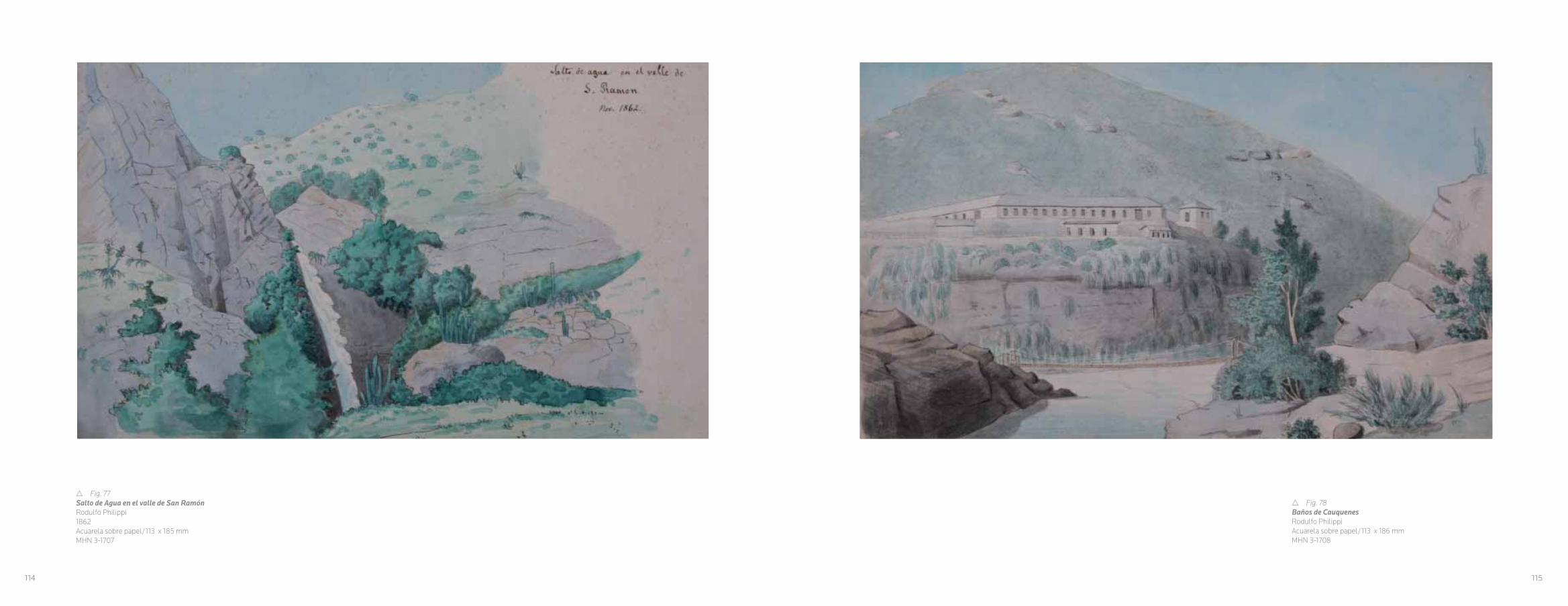
r Fig. 77Salto de Agua en el valle de San RamónRodulfo Philippi 1862Acuarela sobre papel/113 x 185 mmMHN 3-1707
r Fig. 78Baños de Cauquenes Rodulfo Philippi Acuarela sobre papel/113 x 186 mmMHN 3-1708
114 115

r Fig. 79Valle de los cipreses Rodulfo Philippi 1875Tinta sobre papel/113 x 186 mmMHN 3-1704
w Fig. 80Incendio de Valparaíso ( 15 de Marzo 1843)Grabado/Hoja 294 x 370 mmMHN 3-37225Dibujo de Mauricio Rugendas, grabado por A.M. Hubert impreso por Becquet fréres
116 117

v Fig. 81Guanta (Valle de Coquimbo)Grabado/Papel 306 x 420 mmMHN 3-37260Dibujo de Claudio Gay, grabado por H. Vanderbug impreso por Lemercier
r Fig. 82Puerto de HuascoGrabado/Papel 223 x 309 mmMHN 3-37225Dibujo de Claudio Gay, grabado por F. Lehnert impreso por Becquet frères
118 119

r Fig. 83Vue Valdivia prise de l’ile de la TejaVista de Valdivia tomada de la Isla Teja.Grabado/Hoja 316 x 448 mmMHN 3-37307Dibujo de Claudio Gay, grabado por H.Wander- Burch, impreso por Lemercier.
w Fig. 84Laguna de AculeoGrabado Hoja 300 x 374 mmMHN 3-37227Dibujo de José Gandarillas, grabado por H. Vander-Burch, impre-so por Lemercier.
120 121

v Fig. 85Provincia de AtacamaPlano topográfico y geológico de la República de Chile, levantado por orden del Gobierno bajo la dirección de A.Pissis Pedro Amado Pissis – Narcisse DesmadrylLitografía coloreada/Hoja 584 x 975 mm MHN 3-28993Impreso por Charles Chardon Aîné en Paris, 1873.
CAPITULO V
CARTOGRAFÍA Y PAISAJE, LA MEDIDA DE LA NACIÓN
Cuando situado sobre una alta cima el viajero echa sus miradas sobre el conjunto de una región montañosa, lo que llama primero su atención es el desorden que parece reinar en la distribución de estas poderosas moles unidas unas a otras por líneas bizarramente contorneadas; pero insensiblemente desaparece la primera impresión y principia a distinguir en este desorden aparente, algunas líneas que repiten de distancia en distancia y parecen todas llevar el mismo rumbo; unas siguen la dirección de la línea de vertientes, otras vienen a cruzar esta línea formando con ella ángulos más o menos abiertos; y la especie de red que resulta de estas numerosas intersecciones forma el bosquejo de la Serranía.
Amado Pissis, 1875 39
La cartografía fue un punto central en la época
moderna, ya que fue una de las herramientas
del mundo europeo para poder conocer y
dominar el orbe. La ciencia se puso al servicio
de generar instrumentos que facilitaran la visión,
la medición y la clasificación de lo observado,
en el contexto de una mirada estética de la
naturaleza, donde el límite con la ciencia era
difuso. La construcción de una nación se
basa en su afirmación territorial, en sus límites
que conforman su unidad y su identidad. La
cartografía en el siglo XIX se sistematizó como
una ciencia, lo que se desarrolló en el contexto
del surgimiento de los estados nacionales.40
En este sentido, una percepción general
sobre la naturaleza de los mapas, es que son
una representación gráfica de algún aspecto
del mundo real, en definitiva una imagen.
La función de un mapa es la de presentar
una realidad geográfica, con las técnicas
topográficas; y el oficio del cartógrafo, donde
la ciencia ha ganado un terreno que había
ocupado el arte.41 No obstante, la cartografía es
la expresión de una construcción social.42 Las
palabras de Pissis, con las que inició su obra,
la Geografía Física de la República de Chile,
recogen este concepto, al manifestar el deseo
del cartógrafo de ordenar y dar cuenta del
paisaje a trtavés de su trabajo.
En esta línea, desde los inicios de Chile
independiente, se planteó la necesidad de que
la nueva nación contara con un cartografía
clara, cuyo objetivo era no solo delimitar
espacios con las naciones vecinas, sino
verificar una buena explotación de los recursos,
como también lograr una buena administración
del territorio.43
El 14 de septiembre de 1830, Diego
Portales, Ministro de estado, por disposición
122 123
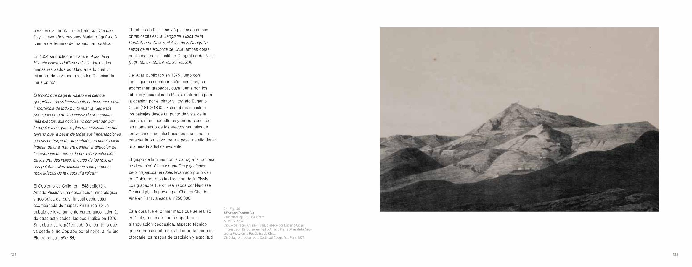
w Fig. 86Minas de ChañarcilloGrabado/Hoja 292 x 416 mmMHN 3-37262Dibujo de Pedro Amado Pissis, grabado por Eugenio Ciceri, impreso por Barousse, en Pedro Amado Pissis: Atlas de la Geo-grafía Física de la República de Chile, Ch Delagrave, editor de la Sociedad Geográfica, París, 1875.
presidencial, firmó un contrato con Claudio
Gay, nueve años después Mariano Egaña dió
cuenta del término del trabajo cartográfico.
En 1854 se publicó en París el Atlas de la Historia Física y Política de Chile, incluía los
mapas realizados por Gay, ante lo cual un
miembro de la Academia de las Ciencias de
París opinó:
El tributo que paga el viajero a la ciencia geográfica, es ordinariamente un bosquejo, cuya importancia de todo punto relativa, depende principalmente de la escasez de documentos más exactos; sus noticias no comprenden por lo regular más que simples reconocimientos del terreno que, a pesar de todas sus imperfecciones, son sin embargo de gran interés, en cuanto ellas indican de una manera general la dirección de las cadenas de cerros, la posición y extensión de los grandes valles, el curso de los ríos; en una palabra, ellas satisfacen a las primeras necesidades de la geografía física.44
El Gobierno de Chile, en 1848 solicitó a
Amado Pissis45, una descripción mineralógica
y geológica del país, la cual debía estar
acompañada de mapas. Pissis realizó un
trabajo de levantamiento cartográfico, además
de otras actividades, las que finalizó en 1876.
Su trabajo cartográfico cubrió el territorio que
va desde el río Copiapó por el norte, al río Bío
Bío por el sur. (Fig. 85).
El trabajo de Pissis se vió plasmada en sus
obras capitales; la Geografía Física de la República de Chile y el Atlas de la Geografía Física de la República de Chile, ambas obras
publicadas por el Instituto Geográfico de París.
(Figs. 86, 87, 88, 89, 90, 91, 92, 93).
Del Atlas publicado en 1875, junto con
los esquemas e información científica, se
acompañan grabados, cuya fuente son los
dibujos y acuarelas de Pissis, realizados para
la ocasión por el pintor y litógrafo Eugenio
Ciceri (1813-1890). Estas obras muestran
los paisajes desde un punto de vista de la
ciencia, marcando alturas y proporciones de
las montañas o de los efectos naturales de
los volcanes, son ilustraciones que tiene un
caracter informativo, pero a pesar de ello tienen
una mirada artística evidente.
El grupo de láminas con la cartografía nacional
se denominó Plano topográfico y geológico de la República de Chile, levantado por orden
del Gobierno, bajo la dirección de A. Pissis.
Los grabados fueron realizados por Narcisse
Desmadryl, e impresos por Charles Chardon
Aîné en Paris, a escala 1:250.000.
Esta obra fue el primer mapa que se realizó
en Chile, teniendo como soporte una
triangulación geodésica, aspecto técnico
que se consideraba de vital importancia para
otorgarle los rasgos de precisión y exactitud
124 125

r Fig. 87Grupo Volcánico de ChillánGrabado/Hoja 292 x 416 mmMHN 3-37269Dibujo de Pedro Amado Pissis, grabado por Eugenio Ciceri, impreso por Barousse, en Pedro Amado Pissis: Atlas de la Geografía Física de la República de Chile, Ch Delagrave, editor de la Sociedad Geográfica, París, 1875.
que debían poseer los levantamientos
topográficos. 46
En términos técnicos de su producción, los
mapas se imprimían a partir de planchas de
cobre, como es el caso de esta serie. La imagen
del mapa se grababa en el cobre al revés,
posteriormente se frotaba la plancha de cobre
con tinta y se limpiaba para que la tinta solo
quedara en las líneas grabadas, a continuación
se colocaba una hoja de papel humedecida y
se presionaba con fuerza contra la plancha de
cobre en la prensa.47 Lo que se condice con el
decreto supremo del 21 de febrero de 1863:
4.º- El Gobierno proporcionará a don Narciso Desmadryl los fondos necesarios para las compras de las planchas de cobre, prensa, papel y tinta que requiere el trabajo, no pudiendo exceder de ochocientos pesos el valor de los artículos, y quedando obligado don Narciso Desmadryl a dar cuenta de la inversión de dichos fondos.48
De estos mapas se realizaron tres ediciones,
la última, coloreada a mano, la que muestra en
toda su plenitud el trabajo cartográfico de Pissis
y el nivel del grabado de Desmadryl.
Resultado de su recorrido a través del país,
Amado Pissis realizó anotaciones y dibujos
sobre el paisaje. Mientras desarrolló el encargo
del gobierno chileno, consistente en ejecutar la
primera carta oficial del territorio, elaboró una
una atmósfera a las vistas. La visión total del
territorio era un desafío para un cartógrafo del
siglo XIX, Amado Pissis asumió ese desafío, a
pesar de que existen zonas en sus mapas que
están vacías, debido a la falta de exploración
de esos extensos territorios, en especial los
que estaban al sur del río Bío Bío y que se
levantaron cartográficamente utilizando mapas
anteriores. No obstante, sus acuarelas nos
adentran a estos territorios, que para los
chilenos de aquella época eran remotos.
Así como el paisaje es una representación
gráfica de un aspecto del mundo real, los
mapas se convierten en lo mismo, ya que
son un tipo de lenguaje, que conlleva signos,
son imágenes con símbolos asociados a la
representación política de un lugar, como es la
nación y son una forma de conocimiento de un
territorio, como los imperativos de un estado
de establecerse como tal.51 En el ámbito del
siglo XIX, la cartografía se convirtió, para las
nuevas naciones americanas, en un elemento
civilizatorio, capaz de superar a la barbarie.
(Figs.107, 108, 109, 110, 111, 112, 113, 114, 115).
serie de acuarelas. Este conjunto de obras49 da
cuenta de la delgada línea que marcaba el límite
entre el arte y la ciencia en el siglo XIX, ya que
un análisis de estas obras da cuenta que:
Pissis demuestra un dominio del color de la composición equilibrada, de la ubicación precisa para construir un espacio de representación. Pissis abandona el modelo explicativo por la mirada del artista que ante el paisaje expresa la soledad, la inmensidad de las cordilleras, el curso de los ríos.50 (Figs. 94, 95, 96, 97, 98, 99, 100, 101, 102, 103, 104).
Sin duda, estas acuarelas sirvieron de fuente
para desarrollar los grabados del Atlas de la Geografía Física de la República de Chile.
Un ejemplo de ello, es la imagen del cerro
Aconcagua, del litógrafo Eugenio Ciceri, la que
está tomada de la acuarela realizada por Pissis
años antes, durante su recorrido por Chile.
(Figs.105, 106).
La lógica de estas acuarelas era mostrar el
paisaje en Chile, desde el desierto de Atacama
hasta la selva valdiviana. La variedad de las
obras, oscilan entre paisajes densos, marcados
por el exotismo y los espacios abiertos de
desiertos, lagos y encumbradas cordilleras.
En algunas de ellas, aparecen personajes y
animales dando cuenta de la proporción y
monumentalidad de los paisajes. La acuarela
como técnica, ayudó a Pissis a conferirle
126 127

CHAPTER V
CARTOGRAPHY AND LANDSCAPE, THE MEASURE OF THE NATION
When standing on a high summit, as the traveler scans a mountainous region, the first thing that captures his attention is the apparently uneven distribution of these powerful giants, linked only among themselves by lines with bizarre shapes; but inexplicably, the first impression disappears and he begins to distinguish amidst this apparent disorder, some lines that are repeated every so often and that appear to point in the same direction; some follow the line of the springs, others surpass it, forming more or less open angles; and the sort of network that results from these numerous intersections forms the sketch of the mountain range.
Amado Pissis, 1875 39
Cartography was of central importance in the modern era, since it was one of the tools that the European world used to understand and dominate the globe. Science was used to generate instruments that facilitated the observation, measurement and classification of what was seen, in the context of an aesthetic outlook on nature, where the frontiers with science were diffuse. The
construction of a nation was based on the affirmation of its territory, on the borders that composed its unity and identity. 19th century cartography was systematized as a science, which developed in the context of the rise of nation states.40
In this sense, a common perception of the nature of maps is that they are graphical representations of some aspect of the real world, basically, an image. The function of a map is to present a geographic reality with topographical techniques. This is the trade of the cartographer, where science invades a territory previously occupied by art.41 However, cartography is the expression of a social construction.42 The words of Pissis, at the beginning of his work Geografía Física de la República de Chile, reveal this concept, manifesting the cartographer’s desire to use his work to organize and account for the landscape.
Thus, from the very beginning of the Chile’s independence, the new nation required a clear cartography of its own, the goal of which was not only to define the borders with its neighboring nations, but also to aid in the exploitation of its resources, as well as the proper administration of its territory.43
On September 14, 1830, Diego Portales, Minister of the State, signed a mapping contract with Claudio Gay by presidential
w Fig. 88Volcán de ChillánPedro Amado Pissis1863Acuarela sobre papel/215 x 300 mmMHN 3-34550
128 129
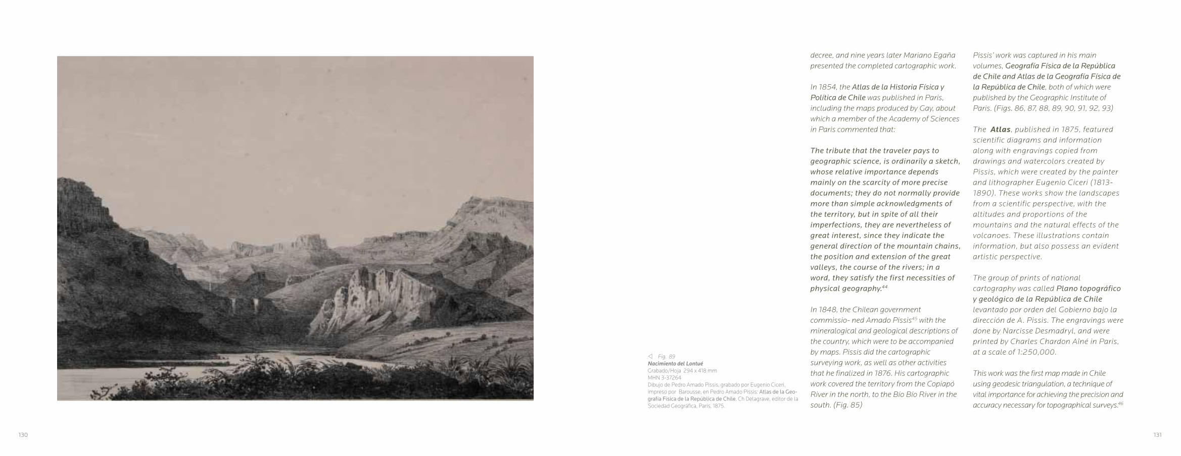
v Fig. 89Nacimiento del LontuéGrabado/Hoja 294 x 418 mmMHN 3-37264Dibujo de Pedro Amado Pissis, grabado por Eugenio Ciceri, impreso por Barousse, en Pedro Amado Pissis: Atlas de la Geo-grafía Física de la República de Chile, Ch Delagrave, editor de la Sociedad Geográfica, París, 1875.
decree, and nine years later Mariano Egaña presented the completed cartographic work.
In 1854, the Atlas de la Historia Física y Política de Chile was published in Paris, including the maps produced by Gay, about which a member of the Academy of Sciences in Paris commented that:
The tribute that the traveler pays to geographic science, is ordinarily a sketch, whose relative importance depends mainly on the scarcity of more precise documents; they do not normally provide more than simple acknowledgments of the territory, but in spite of all their imperfections, they are nevertheless of great interest, since they indicate the general direction of the mountain chains, the position and extension of the great valleys, the course of the rivers; in a word, they satisfy the first necessities of physical geography.44
In 1848, the Chilean government commissio- ned Amado Pissis45 with the mineralogical and geological descriptions of the country, which were to be accompanied by maps. Pissis did the cartographic surveying work, as well as other activities that he finalized in 1876. His cartographic work covered the territory from the Copiapó River in the north, to the Bío Bío River in the south. (Fig. 85)
Pissis’ work was captured in his main volumes, Geografía Física de la República de Chile and Atlas de la Geografía Física de la República de Chile, both of which were published by the Geographic Institute of Paris. (Figs. 86, 87, 88, 89, 90, 91, 92, 93)
The Atlas, published in 1875, featured scientific diagrams and information along with engravings copied from drawings and watercolors created by Pissis, which were created by the painter and lithographer Eugenio Ciceri (1813-1890). These works show the landscapes from a scientific perspective, with the altitudes and proportions of the mountains and the natural effects of the volcanoes. These illustrations contain information, but also possess an evident artistic perspective.
The group of prints of national cartography was called Plano topográfico y geológico de la República de Chile levantado por orden del Gobierno bajo la dirección de A. Pissis. The engravings were done by Narcisse Desmadryl, and were printed by Charles Chardon Aîné in Paris, at a scale of 1:250,000.
This work was the first map made in Chile using geodesic triangulation, a technique of vital importance for achieving the precision and accuracy necessary for topographical surveys.46
130 131

In technical terms, maps were printed from copper plates, as was the case with this series. A mirror image of the desired map was engraved in copper, and then the copper plate was rubbed with ink and wiped so that the ink remained only in the engraved lines. Next, a moist sheet of paper was placed over top of the plate and together they were put through a press where great force was applied.47 This is corroborated by the Supreme Decree issued on February 21, 1863:
4th-The Government shall provide don Narciso Desmadryl with the funds necessary for purchasing the copper plates, press, paper, and ink required for the work, for a value of no more than eight hundred pesos for these items, and don Narciso Desmadryl shall be obliged to account for the investment made with these funds.
Three editions of these maps were made, the last, colored by hand, showed Pissis’ cartographic work in all its splendor, as well as the quality of Desmadryl’s engravings.
As he traveled throughout the country, Amado Pissis took notes and made drawings of the landscape. While he worked on the Chilean government’s commission, which consisted of producing the nation’s first official map, he also created a series of watercolors. This set of pieces49 reveals the fine line between art and science in the 19th
century, since an analysis of these works shows that:
Pissis demonstrates his command of color in a balanced composition, and of the precise placement needed to create space for the representation. Pissis abandoned the explanatory model in favor of the perspective of an artist, who through landscape expresses solitude, the immensity of the mountains, the course of the rivers.50 (Figs. 94 to 104)
Without a doubt, these watercolors were used as sources to develop the engravings of the Atlas de la Geografía Física de la República de Chile. One example of this is the image of Aconcagua Hill by the lithographer Eugenio Ciceri, which was taken from a watercolor done by Pissis years before during his travels in Chile. (Figs. 105, 106)
The idea behind these watercolors was to show the Chilean landscape, from the Atacama Desert to the forests of Valdivia. The variation of these works ranges from dense landscapes marked by exoticism, to open desert spaces, lakes and high mountains. Some of them feature human characters and animals, which are useful for illustrating the proportions and monumentality of the landscapes. The watercolor technique helped Pissis confer an atmosphere to his pictures. Achieving a complete representation of such
a vast territory was a challenge for the 19th century cartographer. However although there remain empty zones on his maps due to limited information available from earlier maps and the lack of exploration of some of the more inaccessible regions, especially those south of the Bio Bio River, Pissis’ watercolors helped illustrate territories that had been remote for Chileans during that era.
Just as the landscape is a graphical repre- sentation of an aspect of the real world, maps became the same thing, since they form a type of symbolic language. These images are symbols associated with the political representation of a place and nation, and are a way of exploring a territory from afar, as well as an imperative for a state to establish itself as such.51 In the 19th century, cartography became a civilizing factor for the new American nations, helping to overcome the unknown. (Figs 107, 108, 109, 110, 111,112,113,114,115)
w Fig. 90Río LontuéPedro Amado PissisAcuarela sobre papel/245 x 180 mmMHN 3-34547
132 133
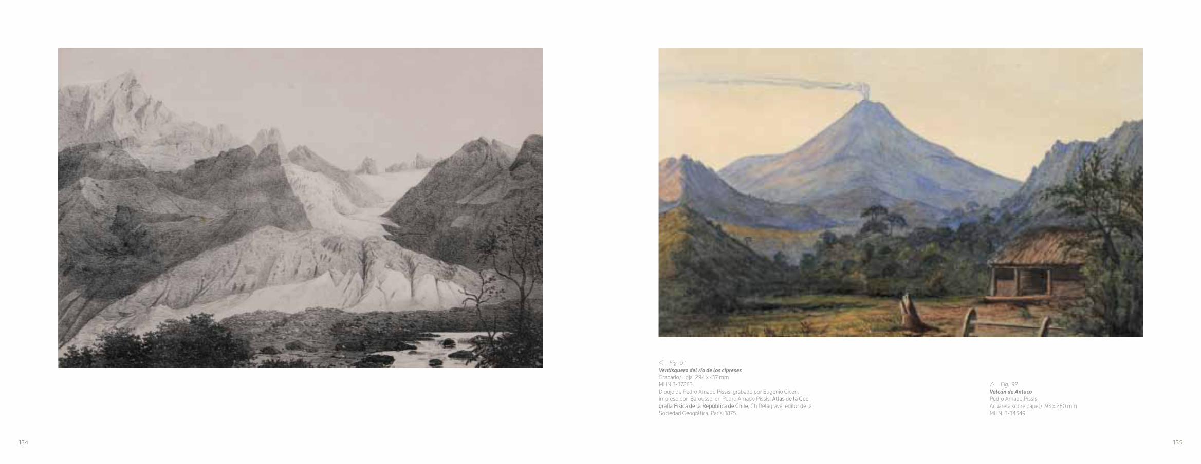
v Fig. 91Ventisquero del río de los cipresesGrabado/Hoja 294 x 417 mmMHN 3-37263Dibujo de Pedro Amado Pissis, grabado por Eugenio Ciceri, impreso por Barousse, en Pedro Amado Pissis: Atlas de la Geo-grafía Física de la República de Chile, Ch Delagrave, editor de la Sociedad Geográfica, París, 1875.
r Fig. 92Volcán de AntucoPedro Amado PissisAcuarela sobre papel/193 x 280 mmMHN 3-34549
134 135

r Fig. 93Interior del cráter del volcán de Antuco, 1869Grabado/Hoja 294 x 414 mmMHN 3-38590Dibujo de Pedro Amado Pissis, grabado por Eugenio Ciceri, impreso por Barousse, en Pedro Amado Pissis: Atlas de la Geo-grafía Física de la República de Chile, Ch Delagrave, editor de la Sociedad Geográfica, París, 1875.
w Fig. 94Desierto de AtacamaPedro Amado Pissis,1870Acuarela sobre papel/230 x 320 mmMHN 3-34527
136 137
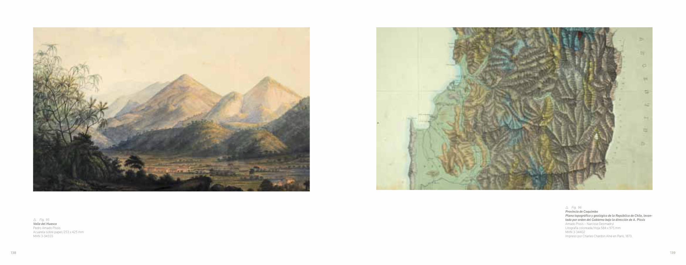
r Fig. 95Valle del HuascoPedro Amado PissisAcuarela sobre papel/253 x 425 mmMHN 3-34555
r Fig. 96Provincia de CoquimboPlano topográfico y geológico de la República de Chile, levan-tado por orden del Gobierno bajo la dirección de A. Pissis Amado Pissis – Narcisse DesmadrylLitografía coloreada/Hoja 584 x 975 mm MHN 3-34402Impreso por Charles Chardon Aîné en Paris, 1873.
138 139

r Fig. 97Río HurtadoPedro Amado Pissis, 1860Acuarela sobre papel/276 x 430 mmMHN 3-34557
w Fig. 98Valle de Aconcagua camino de UspallataPedro Amado Pissi, 1857Acuarela sobre papel/270 x 194 mmMHN 3-345340
140 141

v Fig. 99San FelipePedro Amado PissisAcuarela sobre papel/270 x 420 mmMHN 3-34556
r Fig. 100Provincia de SantiagoPlano topográfico y geológico de la República de Chile levan-tado por orden del Gobierno bajo la dirección de A. Pissis Amado Pissis – Narcisse DesmadrylLitografía coloreada/Hoja 584 x 975 mm MHN 3-34828Impreso por Charles Chardon Aîné en Paris, 1873.
142 143
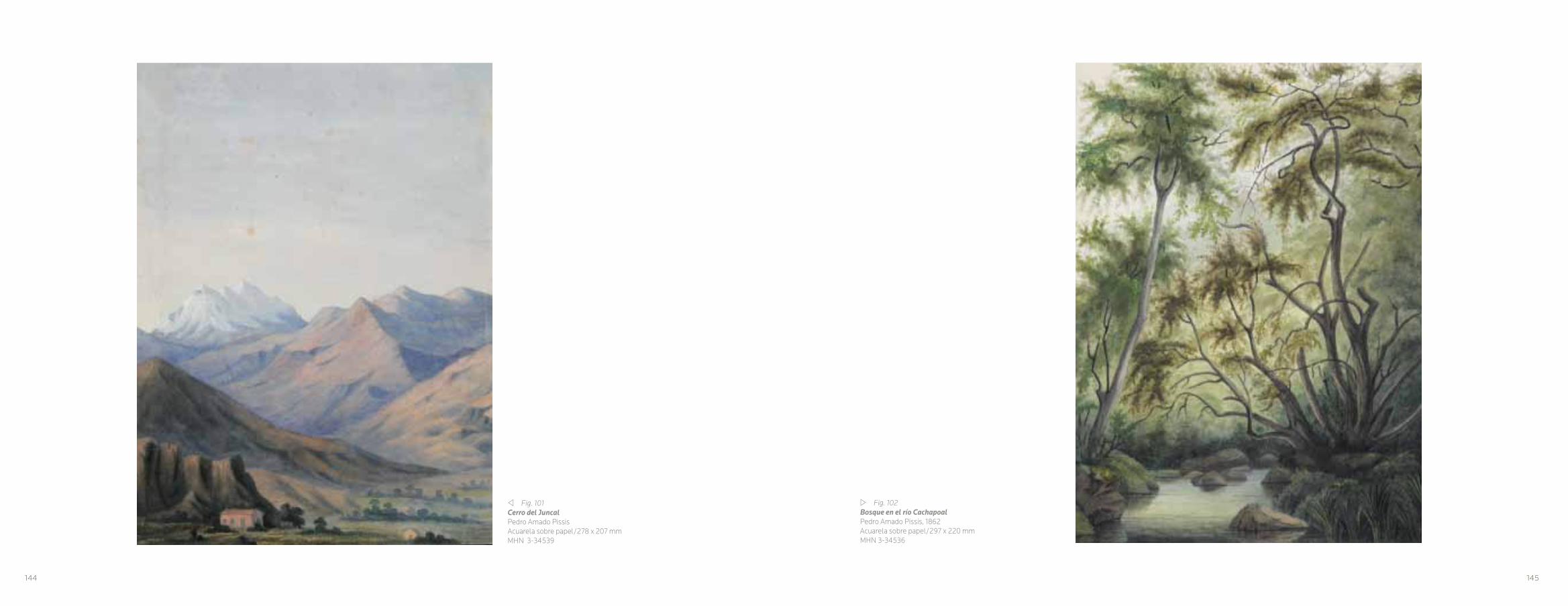
v Fig. 101Cerro del JuncalPedro Amado PissisAcuarela sobre papel/278 x 207 mmMHN 3-34539
w Fig. 102Bosque en el río CachapoalPedro Amado Pissis, 1862Acuarela sobre papel/297 x 220 mmMHN 3-34536
144 145

r Fig. 104Laguna de la LajaPedro Amado Pissis, 1864Acuarela sobre papel/257 x 420 mmMHN 3-34558
r Fig. 103Rocas en Pto. ConstituciónPedro Amado Pissis,1863Acuarela sobre papel/177 x 280 mmMHN 3-34552
146 147

v Fig. 105Volcán de AconcaguaPedro Amado PissisAcuarela sobre papel/282x 211 mmMHN 3-34545
w Fig. 106Cerro de AconcaguaGrabado/Hoja 376 x 290 mmMHN 3-37266Dibujo de Pedro Amado Pissis, grabado por Eugenio Ciceri, impreso por Barousse, en Pedro Amado Pissis: Atlas de la Geo-grafía Física de la República de Chile, Ch Delagrave, editor de la Sociedad Geográfica, París, 1875.
148 149

r Fig. 107Provincia de AraucoPlano topográfico y geológico de la República de Chile levan-tado por orden del Gobierno bajo la dirección de A. Pissis París, 1873Amado Pissis – Narcisse DesmadrylLitografía coloreada/Hoja 584 x 975 mmMHN 3-34832Impreso por Charles Chardon Aîné en Paris, 1873.
r Fig. 108Departamento del ImperialPlano topográfico y geológico de la República de Chile levantado por orden del Gobierno bajo la dirección de A. Pissis París, 1873Amado Pissis – Narcisse DesmadrylLitografía coloreada/Hoja 584 x 975 mm MHN 3-34833Impreso por Charles Chardon Aîné en Paris, 1873.
151150

r Fig. 109Lago de RancoPedro Amado PissisAcuarela sobre papel/210 x 295 mmMHN 3-34558
w Fig. 110Río de ValdiviaPedro Amado PissisAcuarela sobre papel/226 x 310 mmMHN 3-34548
152 153
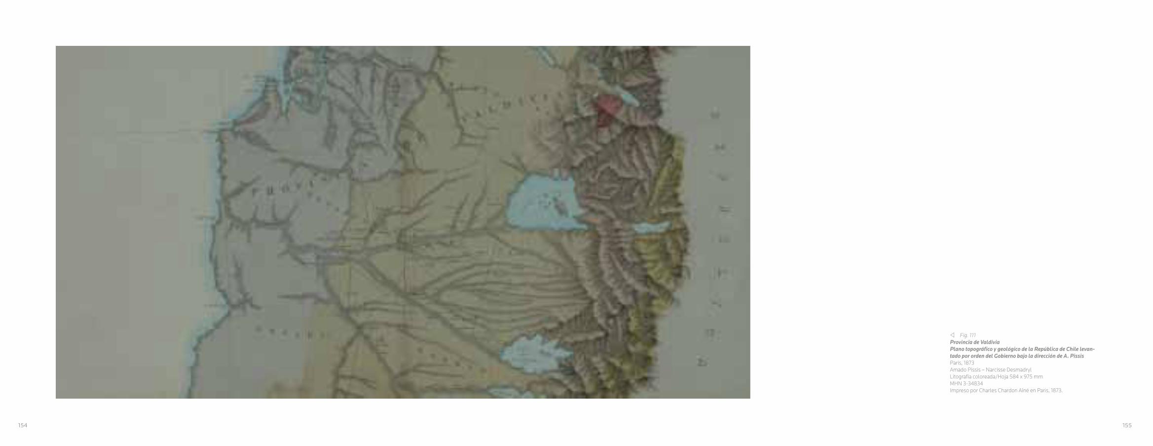
v Fig. 111Provincia de ValdiviaPlano topográfico y geológico de la República de Chile levan-tado por orden del Gobierno bajo la dirección de A. Pissis París, 1873Amado Pissis – Narcisse DesmadrylLitografía coloreada/Hoja 584 x 975 mm MHN 3-34834Impreso por Charles Chardon Aîné en Paris, 1873.
154 155

v Fig. 112Bosques en CorralPedro Amado PissisAcuarela sobre papel/292 x 212 mmMHN 3-34543
w Fig. 113Bosques en Valdivia,Pedro Amado Pissis,Acuarela. sobre papel/300 x 217 mmMHN 3-34537
156 157

r Fig. 114Laguna de LlanquihuePedro Amado Pissis1869Acuarela sobre papel/276 x 428 mmMHN 3-34559
w Fig. 115Paisaje AustralPedro Amado Pissis1857Acuarela sobre papel/315 x 234 mmMHN 3-34533
158 159

CAPITULO VI
EL TRIUNFO DEL PAISAJE
En 1709, Roger de Piles52 escribió su Cours de peinture par príncipes, donde planteó que el
trabajo artístico debía ceñirse con exactitud a
una imitación de la naturaleza. Según de Piles,
para el pintor de paisajes, el mejor modo de
alcanzar tal grado de precisión consistía en
crear pequeños bocetos al óleo al aire libre,
ya que con esta práctica se unía el dibujo
y el color, lo que ayudaba a aumentar el
naturalismo de las pinturas, posteriormente
acabadas en el estudio.53
La teorización propuesta por Roger de
Piles, contribuyó a que la idea del paisaje
construyera una poderosa retórica destinada
a convencer al observador que la práctica
artística de este género pictórico se basara,
en mayor medida, en el contacto directo con
el modelo, a diferencia de otros géneros
artísticos como la pintura de historia o el
retrato, donde el valor de la verosimilitud
podía relativizarse. En este contexto, de Piles
dio una serie de recomendaciones del valor
del arte como una fiel representación de la
realidad, como por ejemplo que los artistas
realizaran un mismo motivo con diferentes
condiciones de luz, a fin de que se pudiera
describir en los dibujos los fenómenos
atmosféricos, un elemento fundamental en las
descripciones científicas.54
Así como la teorización sobre el paisaje como
género artístico, se comenzó a realizar en la
época moderna, su definición, en el caso de
la lengua española es relativamente nueva.
El término paisaje, proveniente del griego
topia, y fue desarrollado posteriormente en
el ámbito latino, como: prospectus, loca amoena, de donde derivó el término italiano
paese, y que por derivación viene paesetto y
paesaggio, traducidos contemporáneamente
del italiano como paisaje. Al igual que el
francés pays y paysage, la raíz latina se
encuentra en el término pagus, definido como:
El distrito determinado de tierras, ó heredades, especialmente de viñas, de donde deriva el
término paganus. 55
En la retórica griega no existe un término que
se acerque al concepto de paisaje, pero sí al
de descripción de lugar; topografía y topotesia,
el lugar real y el lugar ficticio, En el caso de
la retórica latina solo aparece la descritio loci, como el lugar de los hechos.56
En el Diccionario de la Real Academia de
la Lengua Española de 1780, la definición
del paisaje era: Pedazo de país en la pintura,
siguiendo con la definición de país como: la pintura en que están pintados villas, lugares, fortalezas, casas de campo y campañas. Píntase
en lienzos más anchos que altos, para que comprehendiendo mas (sic) horizonte se pueda variar más los objetos.57 Definición que tiene su
correlato en un contexto cultural tributario de la
Ilustración, que permea la definición de paisaje
en la actualidad.58
Desde la perspectiva de los estudios
culturales, entendemos que el paisaje, no
es solo la naturaleza, ni el medio físico que
nos rodea, sino más bien un constructo, una
elaboración mental, un fenómeno cultural que
varía de una cultura a otra.59 Ya Gombrich
lo afirmó al decir que, por paisajismo no se
puede entender la representación de una
escena al aire libre, sino el género artístico
establecido y reconocido como tal.60
En la historia del Arte, los orígenes del arte del
paisaje se habrían desarrollado en los siglos XV
y XVI, en cuyo contexto cultural surgió el interés
por las exploraciones y la descripción de los
territorios, viejos y nuevos. Esto se vio reflejado
en la pintura del entorno natural en que estaba
situado el artista, que como idea surgió en varios
centros artísticos de Europa, de forma gradual a
partir de los comienzos del siglo XV y se volvió
central a los inicios del siguiente siglo.61
En este sentido, fue en las ciudades flamencas,
donde se produjo un foco para el desarrollo del
arte de la pintura del paisaje, como también de
la cartografía.
w Fig. 116Pescador y pintorJean León PalliereTinta sobre papel/247 x 200 mmMHN 3-1677
160 161

r Fig. 117EnsenadaAnónimoAcuarela sobre papel/75 x 277 mmMHN 3-1687
Pintores como Joachim Patinir, Pieter Bruegel
el Viejo, son los iniciadores de un género que
poco a poco logró su autonomía.
Los paisajes se suelen limitar en ese momento a un pequeño espacio en el fondo de las imágenes. Pero una vez iniciado el gusto por este tipo de escenas se desarrollará de forma imparable, hasta convertirse, a partir del siglo XVI, en un género pictórico independiente.62
Un género que se inició en el Renacimiento,
al hacerse evidente la independencia del
fondo de las obras con respecto al motivo
central, logrando una autonomía, que con
el tiempo se institucionalizó, creando un
género exento.63 Para Gombrich, en el
primer lugar donde se comenzó a aplicar el
concepto de paisaje referido a una pintura,
fue en Venecia.64
El desarrollo de este género, fue marcado
por el sello de la subjetividad, si bien hay
una naturaleza como modelo objetivo, los
paisajes se diferencian según el autor. Este
ejercicio pictórico ya lo habría comprobado
Alberti,65 cuando denominó esta operación
como la finestra aperta, (ventana abierta). La
ordenación de los hechos del mundo, vistos
por el artista a través de la perspectiva, cuyo
contenido se puede hacer a través del quadro
(cuadro) como una construcción tridimensional
en apariencia.66
La subjetividad y el realismo se combinaron
a partir del siglo XVIII, esto se debió, a la
importancia que el género paisaje consiguió
entre los artistas Románticos, como es el caso
de Caspar David Friedrich, John Constable,
William Turner y Gustav Courbert, quienes, no
obstante, manifestaron de manera inicial una
ambigüedad en la interpretación del arte del
paisaje.67 Con Courbet, este género se volvió
autónomo, el que después fue consagrado por
los impresionistas.68
Jean León Pallière, tradujo la acción de pintar
un paisaje, como se puede apreciar en su
dibujo, realizado en Chile hacia 1858. Pallière
con su atril frente a una naturaleza es una
cita al asombro de la monumentalidad de la
naturaleza. Paisajes que fueron capturados en
telas, hojas sueltas o libretas de viajes, dando
cuenta del asombro por el inmenso escenario
natural con que se encontraron los artistas
extranjeros, como también los chilenos. (Figs. 116, 117, 118)
Los apuntes y bocetos dan cuenta de la
construcción visual del paisaje, a través de
simples líneas, o aguada de colores que
manifiestan la inmensidad del espectáculo
natural que ofrecía Chile. (Figs. 119, 120)
Esto fue lo que sedujo a Raymond Monvoisin en
sus croquis del campo chileno, como también a
Ernest Goupil, uno de los artistas oficiales de la
expedición de Dumont D’Urville, con las vistas
de la desembocadura del Bío Bío y del puerto de
San Vicente. (Figs. 121, 122, 123, 124)
Un punto de inflexión, en la autonomía del
paisaje en el ámbito nacional, tiene su relación
con la presencia en nuestro país, del pintor
francés Auguste Borget y del bávaro Juan
Mauricio Rugendas, quienes crearon las
imágenes más notables del paisaje de Chile,
desde el punto de vista Romántico.
Borget, quien llegó a Chile en 1837, estaba
adscrito a la corriente romántica, lo que se
puede constatar en sus dibujos a través de
la densidad del claroscuro y las diferentes
valorizaciones de los fondos, cuyo resultado
son paisajes más atmosféricos. La naturaleza,
la agreste cordillera, el valle central, los
alrededores de Santiago y Valparaíso, fueron
los temas que Borget desarrolló a través del
dibujo. Con solo la densidad de sus líneas
y sus espacios en blanco, el artista francés
llegó a crear imágenes diáfanas. Una de
ellas se representa en la litografía Chilenos en descanso en el llano de Santiago, y publicada
posteriormente en 1845 en París en el libro
Fragment d’un Voyage Autour du Monde. Un
trabajo colectivo con Rugendas, ya que se
puede visualizar la mano del pintor bávaro,
tanto en la temática de los huasos, como en
el paisaje de fondo, que representa el valle
de Santiago, tema que fue explotado por
162 163

Rugendas en varias de sus obras pictóricas.
(Figs. 125, 126, 127,128, 129, 130, 131,132, 133)
Con Rugendas, el género del paisaje obtuvo
un reconocimiento, perceptible en la calidad
de sus trabajos de perspectiva, cuyo límite
es la gran cordillera de los Andes, donde
las figuras humanas y el perfil de la ciudad
entregan la verdadera dimensión de un paisaje
monumental. Sus dibujos dieron cuenta de
estos elementos, ligados a su formación
como pintor de las grandes batallas, donde
la tensión de las perspectivas y puntos de
fuga son tributarios de este género. Varios de
sus dibujos, fueron llevados posteriormente
por Claude Gay al Album d’un voyage dans la Republique du Chili, publicado en París en
1854, como son la entrada poniente de la
ciudad de Santiago, o la vista de Valparaíso.
Para Rugendas, su larga permanencia en
Chile, determinó una inmersión en el paisaje
local, a diferencia de los artistas asociados a
las expediciones, los que estaban de paso
por el país y que tenían una dirección en sus
trabajos. Se puede afirmar que Rugendas, se
convirtió en una suerte de bisagra entre el
mandato humboldtiano de percepción científica
y la seducción de caer bajo el dominio de la
naturaleza remota americana.69 (Figs. 134, 135)
Otto Grashof (1812-1876), fue otro de los artistas
que contribuyó con sus obras al repertorio del
paisaje nacional. Estudió arte en Düsseldorf y
Berlín. Inspirado por Humboldt viajó a América.
Llegó a Buenos Aires en 1852, después pasó a
Montevideo. En 1853 decidió viajar a Chile, donde
se quedó hasta 1854. En este lapso de tiempo
captura las imágenes del paisaje, como fue la
Cordillera de los Andes y las visiones del camino
a Valparaíso y las vista de Viña del Mar. Un artista
viajero que en sus trabajos de dibujo, a diferencia
de sus retratos al óleo, presenta una libertad en la
mirada hacia el paisaje con un acento romántico.
(Figs. 136, 137, 138)
En esta línea también se encuentra Ernest
Charton (1816-1877), quien estudió en la
Academia de Bellas Artes de París. Llegó a
Chile en 1843 estableciéndose en Valparaíso y
Santiago. Es uno de los artistas que permaneció
en América, falleciendo en Buenos Aires. Gran
parte de su obra se refiere a lo urbano, pero
tiene dibujos de gran contenido pictórico. A
Charton se le puede definir como un artista
viajero, quienes llegaban a América con la carga
de la búsqueda de lo romántico, a través de lo
exótico y lo pintoresco, de cara a un público
europeo. Además, realizó trabajos de paisajes,
con vistas panorámicas, apropiándose de
manera eficaz de una de las principales claves
románticas del género del paisaje.70
La creación de la Academia de pintura en
1849, fue un punto central en el desarrollo del
paisajismo entre los pintores nacionales. En
estas primeras generaciones se debe destacar
w Fig. 118Volcán Antuco y la Sierra Velluda, 1862Rodulfo Amando PhilippiAcuarela sobre papel/113 x 187 mm.MHN 3-1700
164 165

166
v Fig. 119Croquis de paisajeRaymond MonvoisinGrafito sobre papel/153 x 194 mmMHN 3-1692
la figura de Antonio Smith Irisarri, una suerte de
fundador del arte paisajista nacional, como lo
mencionara Vicente Grez:
Con sus economías de colegial compró telas, pinceles y pinturas, desplegando ardoroso vuelo compuso sus primeros paisajes, consultado mas las aspiraciones de su alma que la verdad de la naturaleza…¡Qué paisajes aquellos! Eran una confusa aglomeración de líneas y colores en que a veces se entrelazaba una gran pincelada maestra que anunciaba al artista.71
Sus obras se basaron en gran parte en el retrato y
el paisaje, su dibujo; Peñalolén, es completamente
atmosférico y personal, lo que rompía la rigidez
de la Academia, la que no consideraba al paisaje
como un género de importancia en la formación
de los alumnos, donde este funcionaba dentro
de una lógica como un buen fondo para motivos
históricos, religiosos y mitológicos, o simplemente,
como copia idéntica de la naturaleza. (Fig. 139)
Esta suerte de negación del paisaje por parte
de la Academia, no anuló el desarrollo de este
género en las Bellas Artes en Chile.72 La pintura fue
utilizada como una herramienta para la formación
de una nueva nación, fomentando una base moral
religiosa y republicana, que generaría un concepto
civilizatorio y moderno. Ya en la segunda mitad del
siglo XIX, la pintura del paisaje se convirtió en una
moda y el Salón la reconoció y le dio una carta de
ciudadanía.
167

CHAPTER VI
THE TRIUMPH OF LANDSCAPE
In 1709, Roger de Piles52 wrote his Cours de peinture par príncipes, where he claimed that artistic work must remain an exact imitation of nature. According to Piles, for the landscape painter, the best way to achieve this degree of precision was to create small outdoor oil sketches, since this practice combined drawing and color, helping to increase the natural feel of the paintings that were later finished in the studio.53
The theory proposed by Roger de Piles contributed to the idea that landscape must build a powerful rhetoric in order to convince the observer that the artistic practice of this pictorial genre was based, to a greater extent, on direct contact with the model, unlike other artistic genres such as history painting or portraiture, where the value of accuracy was relative. In this context, de Piles offered a series of recommendations on the value of art as a faithful representation of reality, such as, for example, that artists should create the same motif with different lighting conditions, so that they could better describe atmospheric phenomena in their drawings, a fundamental aspect of scientific descriptions.54
Just as the theorization regarding landscape as an artistic genre began in the modern era, so too its definition in Spanish is relatively new. Paisaje, the Spanish term for landscape originated as the Greek topia, but was later developed in Latin as prospectus, loca amoena, which led to the Italian term paese. From this derived paesetto and paesaggio, translated from contemporary Italian as landscape. Like the French pays and paysage, the Latin root is also present in the term pagus, defined as a specific district of lands, or estates, particularly vineyards, from which the term paganus is also derived.55
Greek rhetoric has no term similar to the concept of landscape, but it does have some for describing place: topografia and topotesia, the real place and the fictitious place. In the case of Latin, there only exists descritio loci, meaning “the place of the facts.” 56
In the 1780 Dictionary of the Royal Academy of the Spanish Language, the definition of landscape was “piece of country in a painting,” with country then being defined as “the painting that depicts villages, places, forts, country homes and countryside. It is painted on canvases that are wider than they are tall, so that in comprehending more of the horizon, more objects may be included.”57 This definition was created in a cultural context that owed much to the Age
of Enlightenment, and which influenced the current definition of landscape.58
From the perspective of cultural studies, we understand landscape to be not only nature or the physical environment surrounding us, but also a construct, a mental product, a cultural phenomenon that varies from one culture to the next.59 Gombrich has already stated that landscape must not only be understood as the representation of an outdoor scene, but as a fully established and recognized artistic genre.60
Landscape art likely developed in the 15th and 16th centuries, when the cultural context produced an interest in expeditions and the description of old and new lands. This was evident in paintings of the natural surroundings of the artist that gradually became popular in several of Europe’s artistic centers, beginning in the early 15th century and becoming essential by the next century.61
In this vein, it was the Flemish cities that created a hub of artistic development for landscape painting, as well as cartography.
Painters such as Joachim Patinir and Pieter Bruegel the Elder were two of the founders of a genre that slowly gained autonomy.
Landscapes at that moment were often limited to a small space in the background
r Fig. 120Playa de AlgarroboJosé GandarillasGrafito sobre papel/112 x 180 mmMHN 3-1722
168 169

r Fig. 121Bahía de San Vicente, 1838 Ernst GoupilGrafito sobre papel/250 x 432 mmMHN 3-1568
of images. But once it began, the taste for this type of scene began an unstoppable development, until in the early 16th century it became an independent pictorial genre.62
Beginning in the Renaissance as evidenced by the independence of the background from the main motif, this type of scene achieved an autonomy that over time became institutiona- lized, creating a genre with greater freedom.63 For Gombrich, the first place that the concept of landscape began to appear in paintings was in Venice.64
The development of this genre was marked by a seal of subjectivity; although nature is the objective model, landscapes differ according to each author. This pictorial exercise had already been demonstrated by Alberti65 in the operation he called the finestra aperta, or open window. This consists of the organization of the world’s facts, seen by the artist through perspective and produced on the quadro (painting) as a construction with a three-dimensional appearance.66
Subjectivity and realism were combined beginning in the 18th century due to the popularity that the landscape genre enjoyed among Romantic artists such as David Friedrich, John Constable, William Turner, and Gustav Courbert, all of whom manifested an ambiguity in interpreting the art of the landscape.67 With Courbet,
this genre underwent its most radical change, which was later expanded upon by the impressionists.68
Jean León Pallière translated the action of painting a landscape, as can be observed in his drawing, made in Chile around 1858. With his easel facing nature, Pallière’s painting evoked nature’s monumental scale. Landscapes were captured on canvases and loose sheets of paper in travelers’ notebooks, recording the awe of the scenery felt by foreign and Chilean artists. (Fig. 116, 117, 118)
The notes and sketches describe the visual construction of the landscape using simple lines or watercolors, to depict Chile’s immense natural panorama. (Figs. 119, 120)
This was what seduced Raymond Monvoisin in his sketches of the Chilean countryside, as well as Ernest Goupil, one of the official artists on the expedition of Dumont D’Urville, with his scenes of the mouth of the Bio Bio River and the port of San Vicente. (Figs 121, 122, 123, 124)
A turning point for the independence of the landscape genre in Chile was the presence of two foreign artists in the country: the French painter Auguste Borget and the Bavarian Juan Mauricio Rugendas, both of whom created outstanding images of the Chilean landscape from the Romantic perspective.
Borget, who reached Chile in 1837, was a member of the Romantic movement, which is evidenced in his drawings by the density of the chiaroscuro and his emphasis on backgrounds, both of which produced more atmospheric landscapes. Nature, the rugged cordillera, the central valley, the surroundings of Santiago and Valparaíso, were themes that Borget developed in his drawings. With only the density of his lines and blank spaces, the French artist was able to create diaphanous images. One of them is represented in the lithograph Chilenos en descanso en el llano de Santiago, later published in 1845 in Paris in the book Fragment d’un Voyage Autour du Monde. This was a print made in partnership with Rugendas, as we can observe the style of the Bavarian painter both in the huaso theme and the background landscape of the valley of Santiago, a theme explored by Rugendas in several of his pictorial works. (Figs 125, 126, 127,128, 129, 130, 131,132, 133)
With Rugendas, the landscape genre obtai- ned a great talent, perceptible in the quality of his perspective work whose limit was the great cordillera of the Andes, where human figures and the city silhouette provide the true dimensions of a monumental landscape. His drawings highlighted these elements, building on his training as a painter of great battles, where the tension of the perspective and vanishing points are
170 171
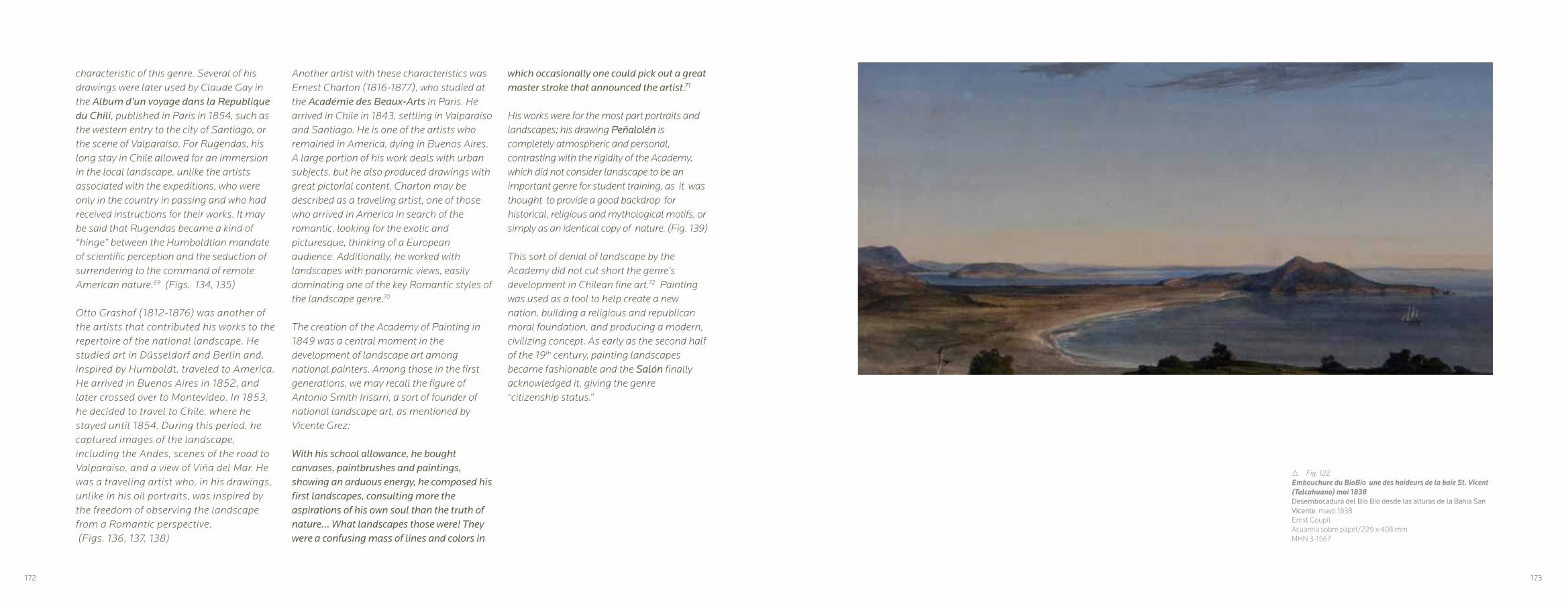
characteristic of this genre. Several of his drawings were later used by Claude Gay in the Album d’un voyage dans la Republique du Chili, published in Paris in 1854, such as the western entry to the city of Santiago, or the scene of Valparaíso. For Rugendas, his long stay in Chile allowed for an immersion in the local landscape, unlike the artists associated with the expeditions, who were only in the country in passing and who had received instructions for their works. It may be said that Rugendas became a kind of “hinge” between the Humboldtian mandate of scientific perception and the seduction of surrendering to the command of remote American nature.69 (Figs. 134, 135)
Otto Grashof (1812-1876) was another of the artists that contributed his works to the repertoire of the national landscape. He studied art in Düsseldorf and Berlin and, inspired by Humboldt, traveled to America. He arrived in Buenos Aires in 1852, and later crossed over to Montevideo. In 1853, he decided to travel to Chile, where he stayed until 1854. During this period, he captured images of the landscape, including the Andes, scenes of the road to Valparaíso, and a view of Viña del Mar. He was a traveling artist who, in his drawings, unlike in his oil portraits, was inspired by the freedom of observing the landscape from a Romantic perspective. (Figs. 136, 137, 138)
Another artist with these characteristics was Ernest Charton (1816-1877), who studied at the Académie des Beaux-Arts in Paris. He arrived in Chile in 1843, settling in Valparaíso and Santiago. He is one of the artists who remained in America, dying in Buenos Aires. A large portion of his work deals with urban subjects, but he also produced drawings with great pictorial content. Charton may be described as a traveling artist, one of those who arrived in America in search of the romantic, looking for the exotic and picturesque, thinking of a European audience. Additionally, he worked with landscapes with panoramic views, easily dominating one of the key Romantic styles of the landscape genre.70
The creation of the Academy of Painting in 1849 was a central moment in the development of landscape art among national painters. Among those in the first generations, we may recall the figure of Antonio Smith Irisarri, a sort of founder of national landscape art, as mentioned by Vicente Grez:
With his school allowance, he bought canvases, paintbrushes and paintings, showing an arduous energy, he composed his first landscapes, consulting more the aspirations of his own soul than the truth of nature… What landscapes those were! They were a confusing mass of lines and colors in
172
which occasionally one could pick out a great master stroke that announced the artist.71
His works were for the most part portraits and landscapes; his drawing Peñalolén is completely atmospheric and personal, contrasting with the rigidity of the Academy, which did not consider landscape to be an important genre for student training, as it was thought to provide a good backdrop for historical, religious and mythological motifs, or simply as an identical copy of nature. (Fig. 139)
This sort of denial of landscape by the Academy did not cut short the genre’s development in Chilean fine art.72 Painting was used as a tool to help create a new nation, building a religious and republican moral foundation, and producing a modern, civilizing concept. As early as the second half of the 19th century, painting landscapes became fashionable and the Salón finally acknowledged it, giving the genre “citizenship status.”
r Fig. 122Embouchure du BioBio une des haideurs de la baie St. Vicent (Talcahuano) mai 1838Desembocadura del Bío Bío desde las alturas de la Bahía San Vicente, mayo 1838 Ernst GoupilAcuarela sobre papel/229 x 408 mmMHN 3-1567
173

w Fig. 124Bajada de cordillera, 1837Auguste BorgetGrafito sobre papel/140 x 160 mmMHN 3-1664
r Fig. 123La alta Cordillera, 16 de julio de 1837Auguste BorgetGrafito sobre papel/210 x 334 mmMHN 3-1666
174 175

r Fig. 125Iglesia de Colina, 1837Auguste BorgetGrafito sobre papel/105 x 200 mmMHN 3-1662
176
r Fig. 126Ranchos en las afueras de Santiago, c.1837Auguste BorgetGrafito sobre papel/160 x 225 mmMHN 3-1663
177

r Fig. 127Laguna de Aculeo, 26 de diciembre 1837Auguste BorgetGrafito sobre papel/231 x 387 mmMHN 3-1724
w Fig. 128Patagual en ChileAuguste BorgetGrafito sobre papel/244 x 305 mmMHN 3-1566
178 179
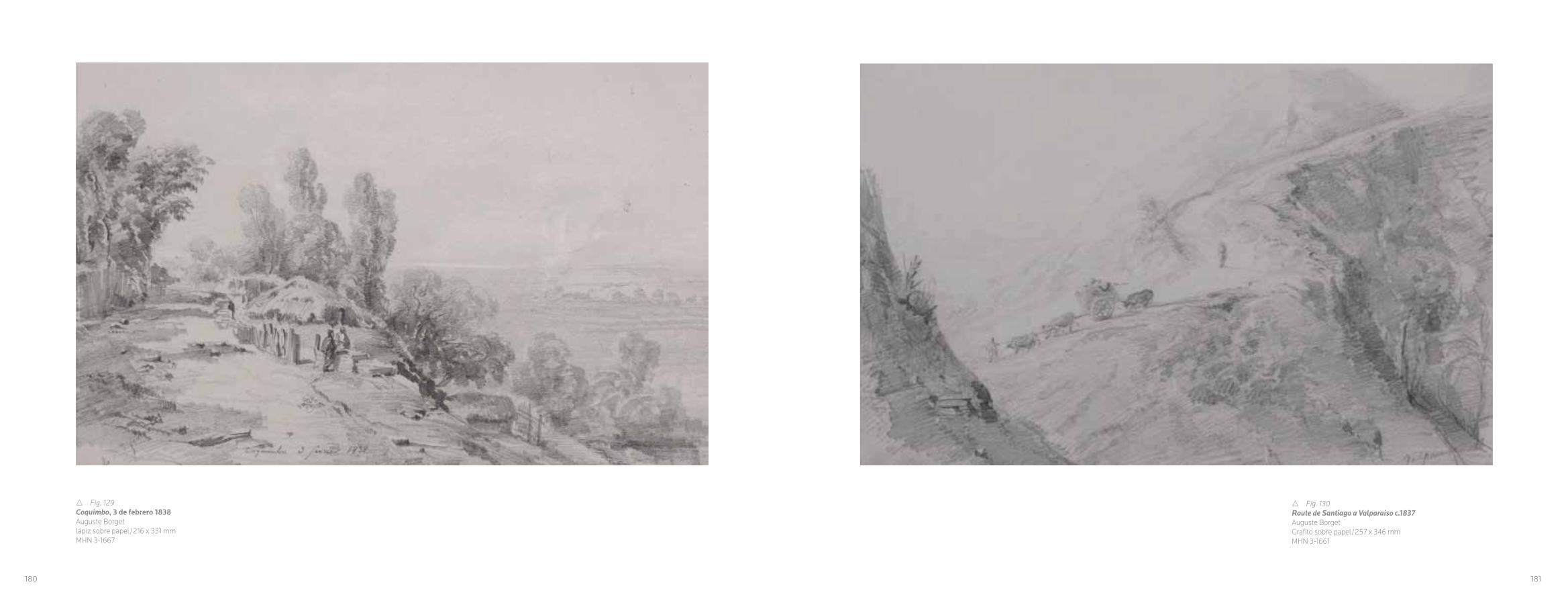
r Fig. 129Coquimbo, 3 de febrero 1838Auguste Borgetlápiz sobre papel/216 x 331 mmMHN 3-1667
180
r Fig. 130Route de Santiago a Valparaiso c.1837Auguste BorgetGrafito sobre papel/257 x 346 mmMHN 3-1661
181
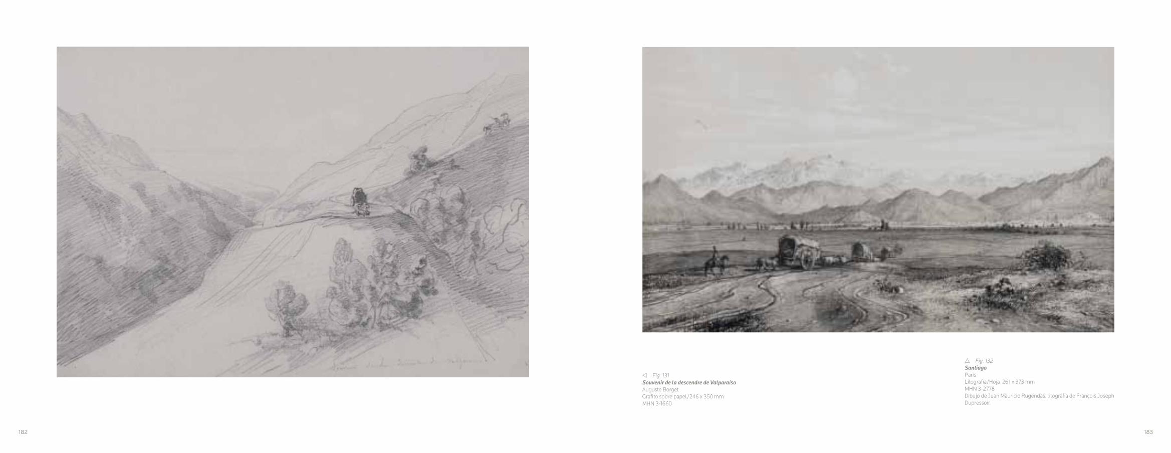
r Fig. 132Santiago París Litografía/Hoja 261 x 373 mmMHN 3-2778Dibujo de Juan Mauricio Rugendas, litografía de François Joseph Dupressoir.
v Fig. 131Souvenir de la descendre de ValparaísoAuguste BorgetGrafito sobre papel/246 x 350 mm MHN 3-1660
182 183

r Fig. 133Valparaíso París Litografía/Hoja 262 x 347 mmMHN 3-27809Dibujo de Juan Mauricio Rugendas, litografía de François Joseph Dupressoir.
w Fig. 134Viña del Mar - Valparaíso, febrero de 1854Otto GrashoffGrafito sobre papel/169 x 268 mmMHN 3-1669
184 185
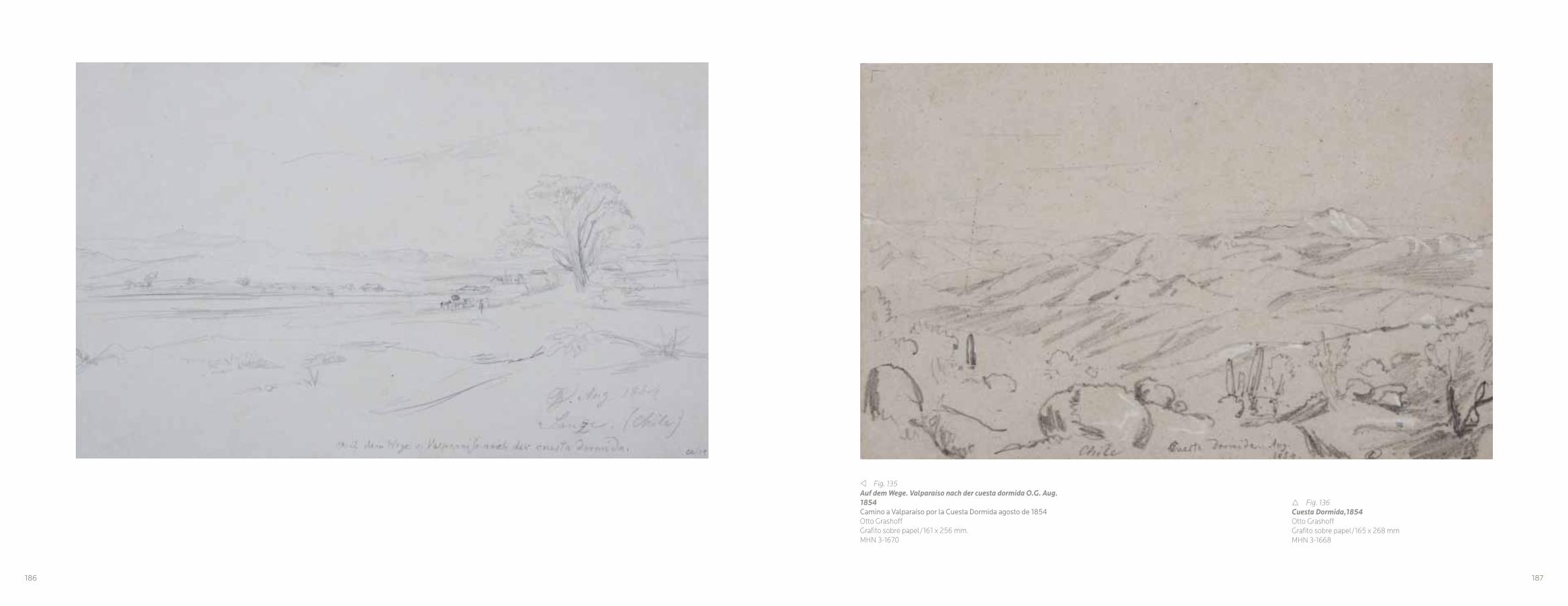
v Fig. 135Auf dem Wege. Valparaíso nach der cuesta dormida O.G. Aug. 1854Camino a Valparaíso por la Cuesta Dormida agosto de 1854Otto GrashoffGrafito sobre papel/161 x 256 mm.MHN 3-1670
r Fig. 136Cuesta Dormida,1854Otto GrashoffGrafito sobre papel/165 x 268 mmMHN 3-1668
186 187
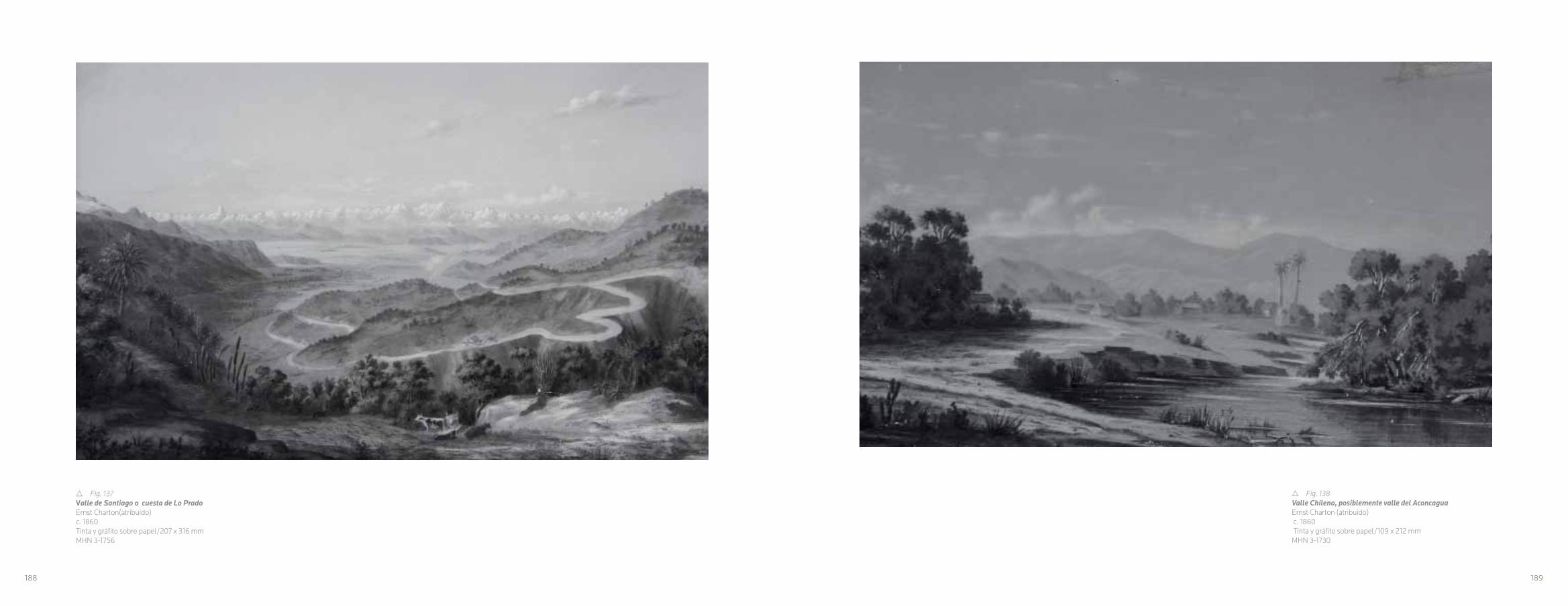
r Fig. 137Valle de Santiago o cuesta de Lo PradoErnst Charton(atribuído)c. 1860Tinta y gráfito sobre papel/207 x 316 mmMHN 3-1756
188
r Fig. 138Valle Chileno, posiblemente valle del AconcaguaErnst Charton (atribuido) c. 1860 Tinta y gráfito sobre papel/109 x 212 mmMHN 3-1730
189

r Fig. 139PeñalolénJosé Smith Irisarri1874Tinta sobre papel/225 x 285 mmMHN 3-1629
190

CITAS
CAPITULO I: EL RECONOCIMIENTO DEL PAISAJE EN LA HISTORIA
VISUAL DE CHILE
1 Mathieu Kessler: El paisaje y su sombra, 2000,p.13.
2 Brian Harley: La nueva naturaleza de los mapas,
Compilación Paul Laxton, 2005.
3 Simon Schama: Landscape and Memory, 1996.
4 Nicolás Ortega Cantero: “Paisaje e identidad. La visión de
Castilla como paisaje nacional (1876-1936)”, en Boletín de la Asociación de Geógrafos Españoles, nº 51, 2009. p. 27.
5 Este trabajo fue parte de la investigación del proyecto
desarrollado en el marco del Fondo de Apoyo a la
Investigación Patrimonial de la Dirección de Bibliotecas,
Archivos y Museos; Construcción y organización del paisaje en Chile, el ordenamiento de un nuevo territorio, dirigido
por Juan Manuel Martínez, Curador del Museo Histórico
Nacional, con la participación de Lina Nagel como co-
investigadora, del Centro de Documentación de Bienes
Patrimoniales de la Subdirección de Museos, proyecto
desarrollado durante el año 2010.
6 Eugenio Pereira Salas: Historia del Arte del Reino de Chile,
1965, pp. 322-324.
7 Eugenio Pereira Salas: Estudios sobre la historia del arte en Chile republicano, 1992.
8 Pereira, 1992, en op. cit.Op. cit. pp.207-233.
9 Miguel Rojas Mix: La Imagen Artística de Chile, Editorial
Universitaria, Santiago de Chile, 1970.
10 Pereira ,1992, p. 209.
11 Op. cit., p. 207.
12 Bernard Smith, citado en op, cit.p. 209.
13 Pereira 1992, pp.
14 Album pittoresque de la fregate La Thetis et de la corvette L’Esperance : collection de dessins relatifs a leur voyage autour du monde en 1824, 1825 et 1826, sous les ordres de M. le baron de Bougainville.París, 1828.
15 Pereira, 1992, pp. 215 – 216.
16 Op. cit., pp. 231- 232.
17 The U.S. Naval Astronomical Expedition to the Southern Hemisphere (La Expedición Astronómica de la Marina de
los Estados Unidos al Hemisferio Sur durante los años
1849, 50, 51 y 52). Consta de tres volúmenes, aunque
antecedentes históricos señalan que, originalmente,
comprendía un total de cinco tomos.
CAPITULO II: CIENCIA Y ARTE, EL DESPERTAR DE LA EXPLORACIÓN DE
LA NATURALEZA REMOTA
18 Viaje a Valparaíso y Santiago de Jorge Vancouver. tomado de los Viajes alrededor del Mundo de Jorge Vancouver, ordenados por el Rey de Inglaterra, en 1790, 1791, 1792, 1793, 1794 y 1795. Traducción de Nicolás Peña M, de la
edición francesa de 1799, Imprenta Mejía, Calle Nataniel
65, Santiago de Chile, 1908, pp. 47-48
19 Nació en Inglaterra en 1757, a los catorce años ingresó
a la marina inglesa. En 1776 participó en los viajes que
James Cook hizo alrededor del mundo. Entre los años 1790
y 1795 realizó un gran periplo de viajes, falleció en 1798.
20 Marta Penhos: Ver, conocer, dominar. Imágenes de
Sudamérica a fines del siglo XVIII, 2005, p. 24.
21 Mary Louise Pratt: Ojos imperiales, Literatura de viajes y transculturización, 2010, p.45.
22 Marisa González Montero de Espinosa: La Ilustración del Hombre Americano, 1992, p 16 ss.
23 Citado González Montero de Espinosa, 1992, p.11.
24 A voyage round the world, in the years MDCCXL, I, II, III, IV,
by George Anson, Esq., commander in chief of a squadron of His Majesty’s ships, sent upon an expedition to the South-Seas / compiled from papers and others materials of the Right Honourable George Lord Anson, and published under the direction by Richard Walter.
25 Gran parte de este material está en la actualidad en el
Museo Naval de Madrid.
26 Viaje político-científico alrededor del mundo de las corbetas Descubierta y Atrevida al mando de los capitanes de navío D. Alejandro Malaspina y D. José Bustamante y Guerra desde 1789 a 1794.
27 Pereira 1965, pp.
CAPITULO IIIITINERARIO DE LA MIRADA, LA DESCRIPCIÓN DE UN
NUEVO TERRITORIO
28 Hernán Rodríguez: Antiguos Grabados de Chile, 1991, p. 6.
29 Leonardo Espinoza Gho, “La cartografía Histórica de
Santiago, desde la colonia hasta Ansart (1541-1875)”en
El catastro Urbano de Santiago, orígenes, desarrollo y aplicaciones, Miguel, Saavedra, editor, 2008, p. 64.
30 Charles Darwin, citado en Darwin en Chile (1832-1835) Viaje de un naturalista alrededor del mundo, edición y prólogo por David Yudilevich, 1995, p. 138.
31 En el libro de Gilliss; The U.S. Naval Astronomical Expedition to the southern hemisphere during the years 1849-’50-’51-’52 Nicholson Printer, Nueva York, 1855.
32 Germán Hidalgo: Vistas panorámicas de Santiago 1790-1910, su desarrollo urbano bajo la mirada de dibujantes, pintores y fotógrafos, 2009, p. 115.
CAPITULO IVLOS PINTORES VIAJEROS, ENTRE LA VISIÓN CIENTÍFICA Y
LA PERSPECTIVA ARTÍSTICA
33 Alexander von Humboldt, citado por Ottmar Ette: “El
Cosmos de la vida: Alexander von Humboldt y su obra
mayor, en Rafael Sagredo (edit) Ciencia-mundo. Orden republicano, arte y nación en América, 2010, p. 328.
34 Ette, 2010, pp. 329 ss.
35 Impreso por Harper & Brothers en Nueva York en 1835,
en el marco de la publicación; Voyage of the United States frigate Potomac : under the command of Commodore John Downes, during the circumnavigation of the globe, in the years 1831, 1832, 1833, and 1834; including a particular account of the engagement at Quallah-Battoo, on the coast of Sumatra; with all the official documents relating to the same. by J. N. Reynolds, impreso en Nueva York en 1835.
36 Pereira, 1992, p.49.
37 Impreso por Lemercier, Bernard y Cie. París, 1841
38 Semanario Pintoresco Español, Madrid, 9 de noviembre
de 1851, p (45) 353.
CAPITULO VCARTOGRAFÍA Y PAISAJE, LA MEDIDA DE
LA NACIÓN
39 Amado Pissis: Geografía Física de la República de Chile,
1875, p. 1.
40 Laura Malosetti Costa: Pampa, ciudad y suburbio, Catá-
logo de la exposición, 2007, pp. 18-19.
41 J.Brian Harley, 2005, p. 60.
42 Op. cit. p. 61.
43 José Ignacio González Leiva: “Primeros levantamientos
cartográficos generales de Chile con base científica: los
mapas de Claudio Gay y Amado Pissis”, en Revista de Geografía Norte Grande, Nº 38, 2007, p. 22.
44 Boussingault, citado por Ernesto Greve: “Don Amado
Pissis y sus trabajos geográficos y geológicos en Chile”, en
Revista Chilena de Historia y Geografía, Nº 107, 1946, p. 79.
45 Pedro José Amado Pissis, nació en 1812 en Francia,
estudio en la Escuela de Minas de París y en la Escuela
Politécnica.
46 González, 2007, p. 36.
47 Peter van der Krogt: Joan Blaeu, Atlas Maior de 1665,
2006, p. 30.
48 Greve, 1946, p. 105.
49 Esta serie de acuarelas fue comprada por el Museo His-
tórico Nacional en 1984.
50 Roberto Amigo: “Relato Curatorial”, en Catálogo de la Trienal de Chile 2009, Ticio Escobar y Nelly Richards (edit),
2009, p. 175.
51 Harley, 1996, pp. 80-81.
CAPITULO VIEL TRIUNFO DEL PAISAJE
52 Roger de Piles, (1635-1709)
53 Ver, Jonathan Clarkson, Constable, 2010, p. 70.
54 Op. cit., p. 72.
55 Javier Maderuelo: El Paisaje, Génesis de un concepto,
2005, p. 16.
56 Maderuelo, 2005, p. 18.
57 Diccionario de la Lengua castellana, compuesto por la
Real Academia Española, reducido a un tomo para su más
fácil uso, 1780, p. 676.
58 Paisaje: Extensión de terreno que se ve desde un
sitio// Extensión de terreno considerada en su aspecto
artístico// Pintura o dibujo que representa cierta extensión
de terreno. En: Diccionario de la Lengua Española, Real
Academia Española, vigésima segunda edición, tomo II,
Espasa Calpe, Madrid, 2001, p.1647.
59 Maderuelo, 2005,p. 17.
60 Ernst. Gombrich: “Teoría del arte renacentista y el
nacimiento del paisajismo, en Norma y forma, estudio
sobre el arte del renacimiento, 1999, p. 107.
61 Alejandro Vergara: Patinir y la invención del Paisaje, 2007, p. 7.
62 Ibíd.
63 Gombrich , 1999, p.109.
64 Ibíd.
65 León Battista Alberti (1404-1472). Sacerdote, arquitecto
y humanista italiano.
66 Werner Hofmann: “Las partes y el todo”, en La abstracción del Paisaje. Del romanticismo nórdico al expresionismo abstracto, Catalogo de la exposición,
Fundación Juan March, 2007, p. 19.
67 Ver la obra de Ariel Denis y Isabelle Julia: L’Art Romantique, 1996.
68 Kessler, 2000, p. 13.
69 Roberto Amigo: “Relato curatorial”, en Ticio Escobar y
Nelly Richard, Catálogo Trienal de Chile, 2009, pp. 173-174.
70 Ver Marta Penhos, Arte siglo XIX, Parte 1, Museo Nacio-
nal de Bellas Artes, Catálogo, Roberto Amigo editor, 2010,
p. 284.
71 Vicente Grez: Antonio Smith, Historia del Paisaje en Chile,
1882, p. 16.
72 Amigo, 2009, p. 171.
192 193

NOTES
CHAPTER I: RECOGNIZING THE LANDSCAPE IN CHILEAN VISUAL HISTORY
1 Mathieu Kessler: El paisaje y su sombra,. 2000, p.13.
2 Brian Harley: La nueva naturaleza de los mapas, Compilación Paul Laxton, 2005.
3 Simon Schama,: Landscape and Memory, 1996.
4 Nicolás Ortega Cantero: “Paisaje e identidad. La visión de Castilla como paisaje nacional (1876-1936)”, in Boletín de la Asociación de Geógrafos Españoles, Nº 51, 2009. pg. 27.
5 This piece belonged to the investigation of the project developed as part of the support fund for heritage research of the Direction of Libraries, Archives and Museums; Construcción y organización del paisaje en Chile, el ordenamiento de un nuevo territorio, directed by Juan 1 1Mathieu Kessler: El paisaje y su sombra,. 2000, p.13.
2 Brian Harley: La nueva naturaleza de los mapas, Compilación Paul Laxton, 2005.
3 Simon Schama,: Landscape and Memory, 1996.
4 Nicolás Ortega Cantero: “Paisaje e identidad. La visión de Castilla como paisaje nacional (1876-1936)”, in Boletín de la Asociación de Geógrafos Españoles, Nº 51, 2009. pg. 27.
5 This piece belonged to the investigation of the project developed as part of the Support Fund for Heritage Research of the Direction of Libraries, Archives and Museums; Construcción y organización del paisaje en Chile, el ordenamiento de un nuevo territorio, direc-ted by Juan Manuel Martínez, Curator of the National Historical Museum, with the participation of Lina Nagel as co-researcher, from the Center of Documentation of Heritage Sites of the Subdi-rection of Museums, a project executed during 2010.
6 Eugenio Pereira Salas: Historia del Arte del Reino de Chile, 1965, pgs. 322-324.
7 Eugenio Pereira Salas: Estudios sobre la historia del arte en Chile republicano, 1992, pgs..207-233.
8 Pereira, 1992, in op. cit.
9 Miguel Rojas Mix: La Imagen Artística de Chile, Editorial Universi-taria, Santiago de Chile, 1970.
10 Pereira ,1992, pg. 209.
11 Op. cit., pg. 207.
12 Bernard Smith, quoted in op, cit., pg. 209.
13 Pereira 1992, pp.
14 Album pittoresque de la fregate La Thetis et de la corvette L’Esperance : collection de dessins relatifs a leur voyage autour du monde en 1824, 1825 et 1826, sous les ordres de M. le baron de Bougainville.París, 1828.
15 Pereira, 1992, pgs. 215 – 216.
16 Op. cit., pgs. 231- 232.
17 The U.S. Naval Astronomical Expedition to the Southern He-misphere (during 1849, 50, 51 and 52). Includes three volumes, although historical data indicates that it originally inclded five volumes.
CHAPTER II: SCIENCE AND ART, THE EXPLORATION OF REMOTE NATURE AWAKENS
18 Viaje a Valparaíso y Santiago de Jorge Vancouver. tomado de los Viajes alrededor del Mundo de Jorge Vancouver, ordenados por el Rey de Inglaterra, en 1790, 1791, 1792, 1793, 1794 y 1795. Transla-ted by Nicolás Peña M, from the French edition of 1799, Imprenta Mejía, Calle Nataniel 65, Santiago de Chile, 1908, pgs. 47-48
19 He was born in England in 1757, and joined the English Navy at the age of fourteen. In 1776, he participated in the journeys of Ja-mes Cook around the world. Between 1790 and 1795 he went on a series of long journeys, and died in 1798.
20 Marta Penhos: Ver, conocer, dominar. Imágenes de Sudamérica a fines del siglo XVIII, 2005, pg. 24.
21 Mary Louise Pratt: Ojos imperiales, Literatura de viajes y transcul-turización, 2010, pg. 45.
22 Marisa González Montero de Espinosa: La Ilustración del Hom-bre Americano, 1992, pg. 16 ss.
23 Citado González Montero de Espinosa, 1992, pg. 11.
24 A voyage round the world, in the years MDCCXL, I, II, III, IV, by George Anson, Esq., commander in chief of a squadron of His Majesty’s ships, sent upon an expedition to the South-Seas / compi-led from papers and others materials of the Right Honourable Geor-ge Lord Anson, and published under the direction by Richard Walter
25 A large part of this material is currently in the Naval Museum of Madrid.
26 Viaje político-científico alrededor del mundo de las corbetas Des-cubierta y Atrevida al mando de los capitanes de navío D. Alejandro Malaspina y D. José Bustamante y Guerra desde 1789 a 1794
27 Pereira 1965, pgs.
CHAPTER III: ITINERARY OF A PERSPECTIVE, THE DESCRIPTION OF A NEW TERRITORY
28 Hernán Rodríguez: Antiguos Grabados de Chile, 1991, pg. 6.
29 Leonardo Espinoza Gho, “La cartografía Histórica de Santia-go, desde la colonia hasta Ansart (1541-1875) “ in El catastro Urbano de Santiago, orígenes, desarrollo y aplicaciones, Mi-guel, Saavedra , editor, 2008, pg. 64.
30 Charles Darwin, quoted in Darwin en Chile (1832-1835) Viaje de un naturalista alrededor del mundo, edition and prologue by David Yudilevich, 1995, pg. 138.
31 In the book by Gilliss: The U.S. Naval Astronomical Expedition to the southern hemisphere during the years 1849-’50-’51-’52 Nichol-son Printer, Nueva York, 1855.
32 Germán Hidalgo: Vistas panorámicas de Santiago 1790-1910, su desarrollo urbano bajo la mirada de dibujantes, pintores y fotógra-fos, 2009, pg. 115.
CHAPTER IV: TRAVELING PAINTERS, BETWEEN SCIENTIFIC VISION AND ARTISTIC PERSPECTIVE
33 Alexander von Humboldt, quoted by Ottmar Ette: “El Cosmos de la vida: Alexander von Humboldt y su obra mayor, en Rafael Sagredo (edit) Ciencia-mundo. Orden republicano, arte y nación en América, 2010, pg. 328.
34 Ette, 2010, pgs. 329 ss.
35 Printed by Harper & Brothers in New York in 1835, as part of the publication; Voyage of the United States frigate Potomac: under the command of Commodore John Downes, during the circumna-vigation of the globe, in the years 1831, 1832, 1833, and 1834; inclu-ding a particular account of the engagement at Quallah-Battoo, on the coast of Sumatra; with all the official documents relating to the same. by J. N. Reynolds, printed in New York in 1835.
36 Pereira, 1992, pg.49.
37 Printed by Lemercier, Bernard et al. París, 1841.
38 Spanish Painting Seminar, Madrid, November 9, 1851, pg. (45) 353.
CHAPTER V: CARTOGRAPHY AND LANDSCAPE, THE MEASURE OF THE NATION
39 Amado Pissis: Geografía Física de la República de Chile, 1875, pg. 1.
40 Laura Malosetti Costa: Pampa, ciudad y suburbio, Catálogo de la exposición, 2007, pgs. 18-19.
41 J.Brian Harley, 2005, pg. 60.
42 Op. cit. pg. 61.
43 José Ignacio González Leiva: “Primeros levantamientos cartográficos generales de Chile con base científica: los mapas de Claudio Gay y Ama-do Pissis”, in Revista de Geografía Norte Grande, Nº 38, 2007, pg. 22.
44 Boussingault, quoted by Ernesto Greve: “Don Amado Pissis y sus trabajos geográficos y geológicos en Chile”, in Revista Chilena de Historia y Geografía, Nº 107, 1946, pg. 79.
45 Pedro José Amado Pissis, born in 1812 in France, studied at the School of Mines in Paris and the Polytechnical School.
46 González , 2007, pg. 36.
47 Peter van der Krogt: Joan Blaeu, Atlas Maior de 1665, 2006, pg. 30.
48 Greve, 1946, pg. 105.
49 This series of watercolors was purchased by the National Histori-cal Museum in 1984.
50 Roberto Amigo: “Relato Curatorial”, in Catalogo de la Trienal de Chile 2009, Ticio Escobar and Nelly Richards (edit), 2009, pg. 175.
51 Harley, 1996, pgs. 80-81.
CHAPTER VI: THE TRIUMPH OF LANDSCAPE
52 Roger de Piles, (1635-1709).
53 Ver, Jonathan Clarkson, Constable, 2010, pg. 70.
54 Op. cit., pg. 72.
55 Javier Maderuelo: El Paisaje, Génesis de un concepto, 2005, pg. 16.
56 Maderuelo, 2005, pg. 18.
57 Diccionario de la Lengua castellana, compuesto por la Real Aca-demia Española, reducido a un tomo para su más fácil uso, 1780, pg. 676.
58 Landscape: extension of land seen from one site // Extension of land considered in its artistic aspect // Painting or drawing repre-senting a certain extension of land. In: Diccionario de la Lengua Española, Real Academia Española, vigésima segunda edición, tomo II, Espasa Calpe, Madrid, 2001, pg.1647.
59 Maderuelo, 2005, pg. 17.
60 Ernst. Gombrich: “Teoría del arte renacentista y el el nacimiento del paisajismo, in Norma y forma, estudio sobre el arte del renaci-miento, 1999, pg. 107.
61 Alejandro Vergara: Patinir y la invención del Paisaje, 2007, pg. 7.
62 Ibíd.
63 Gombrich , 1999, pg.109.
64 Ibíd.
65 León Battista Alberti (1404-1472). Italian priest, architect and humanist.
66 Werner Hofmann “Las partes y el todo”, in La abstracción del Paisaje. Del romanticismo nórdico al expresionismo abstracto, Catalogo de la exposición, Fundación Juan March, 2007, pg. 19.
67 See the work of Ariel Denis and Isabelle Julia: L’Art Romantique, 1996.
68 Kessler, 2000, pg. 13.
69 Roberto Amigo: “Relato curatorial”, in Ticio Escobar and Nelly Richard, Catalogo Trienal de Chile, 2009, pgs. 173-174.
70 See Marta Penhos, Arte siglo XIX, Parte 1, Museo Nacional de Bellas Artes, Catálogo, Roberto Amigo editor, 2010, pg. 284.
71 Vicente Grez: Antonio Smith, Historia del Paisaje en Chile, 1882, pg. 16.
72 Amigo, 2009, pg. 171.
194 195

Penhos, Marta: Ver, conocer, dominar. Imágenes de Sudamérica a fines del siglo XVIII, Siglo XXI Editores,
Buenos Aires, 2005.
Pereira Salas, Eugenio: Historia del Arte del Reino de Chile,
Ediciones de la Universidad de Chile, Santiago de Chile,
1965.
Pereira Salas, Eugenio: Estudios sobre la historia del arte en Chile republicano 1992, Ediciones de la Universidad de
Chile, Santiago de Chile, 1992.
Pissis, Amado: Geografía Física de la República de Chile,
Instituto Geográfico de París, Ch. Delagrave, París, 1875.
Pratt, Mary Louise: Ojos imperiales, Literatura de viajes y transculturización, Fondo de Cultura Económica, México, 2010.
Rodríguez, Hernán: Antiguos Grabados de Chile, Instituto
Cultural de Las Condes, Santiago de Chile, 1991.
Schama, Simon: Landscape and Memory, Vintage Books,
Nueva York, 1996.
Van der Krogt, Peter: Joan Blaeu, Atlas Maior de 1665,
Taschen, Colonia, 2006.
BIBLIOGRAFIA:
Amigo, Roberto:“Relato Curatorial”, en Catálogo de la Trienal de Chile 2009, Ticio Escobar y Nelly Richards (Editores),
Fundación Trienal de Chile, Santiago de Chile, 2009.
Espinoza Gho, Leonardo: “La cartografía Histórica de
Santiago, desde la colonia hasta Ansart (1541-1875)”
en El catastro Urbano de Santiago, orígenes, desarrollo y aplicaciones, Miguel Saavedra (Editor), Dirección de Obras,
Ilustre Municipalidad de Santiago, Santiago de Chile, 2008.
Ette, Ottmar: El Cosmos de la vida: Alexander von
Humboldt y su obra mayor, en Rafael Sagredo (Editor)
Ciencia-mundo. Orden republicano, arte y nación en
América, Centro de Investigaciones Diego Barros Arana,
Editorial Universitaria, Santiago de Chile, 2010.
Darwin, Charles: Darwin en Chile (1832-1835) Viaje de un naturalista alrededor del mundo, David Yudilevich (Edición y
prólogo), Editorial Universitaria, Santiago de Chile, 1995.
Denis, Ariel; Julia, Isabelle: L’Art Romantique, Éditions d’art
Somogy, París, 1996.
Diccionario de la Lengua Castellana, compuesto por la Real
Academia Española, reducido a un tomo para su más fácil
uso, Joaquín Ibarra, Impresor de Cámara de S.M. y de la
Real Academia, Madrid 1780.
Diccionario de la Lengua Española, Real Academia Española,
vigésima segunda edición, tomo II, Espasa Calpe, Madrid,
2001
Gombrich, Ernst: “Teoría del arte renacentista y el
nacimiento del paisajismo, en Norma y forma, estudio sobre el arte del renacimiento, Editorial Debate, Madrid, 1999.
González Montero de Espinosa, Marisa: La Ilustración del Hombre Americano. Consejo Superior de Investigaciones
Científicas, Madrid, 1992.
González Leiva, José Ignacio: “Primeros levantamientos
cartográficos generales de Chile con base científica:
los mapas de Claudio Gay y Amado Pissis”, en Revista de Geografía Norte Grande, Nº 38, Pontificia Universidad
Católica de Chile, Santiago de Chile, 2007.
Greve, Ernesto: “Don Amado Pissis y sus trabajos
geográficos y geológicos en Chile”, en Revista Chilena de Historia y Geografía, Nº 107,
Imprenta Universitaria.
Santiago de Chile, 1946.
Grez, Vicente: Antonio Smith, Historia del Paisaje en Chile,
Establecimiento Tipográfico de La Época, Santiago de
Chile, 1882.
Kessler, Mathieu: El paisaje y su sombra. Idea Books,
Barcelona, 2000.
Harley, Brian: La nueva naturaleza de los mapas, Compilación
Paul Laxton, Fondo de Cultura Económica, México, 2005.
Hidalgo, Germán: Vistas panorámicas de Santiago 1790-1910, su desarrollo urbano bajo la mirada de dibujantes, pintores y fotógrafos, Ediciones de la Universidad Católica de Chile,
Origo Ediciones, Santiago de Chile, 2010.
Hofmann, Werner: “Las partes y el todo”, en La abstracción del Paisaje. Del romanticismo nórdico al expresionismo abstracto, Catálogo de la exposición, Fundación Juan
March, Madrid 2007.
Larkson, Jonathan C.: Constable, Phaidon Press,
Barcelona, 2010.
Maderuelo, Javier: El Paisaje, Génesis de un concepto, Abada
editores, Madrid, 2005.
Malosetti Costa, Laura: Pampa, ciudad y suburbio, Catálogo
de la exposición, Fundación OSDE, Buenos Aires, 2007.
Ortega Cantero, Nicolás: “Paisaje e identidad. La visión de
Castilla como paisaje nacional (1876-1936)”, en Boletín de la Asociación de Geógrafos Españoles, nº 51, 2009.
BIBLIOGRAPHY:
Amigo, Roberto: “Relato Curatorial,” in Catalogo de la Trienal de Chile 2009, Ticio Escobar and Nelly Richards (Editors), Fundación Trienal de Chile, Santiago de Chile, 2009.
Espinoza Gho, Leonardo: “La Cartografía Histórica de Santiago, desde la Colonia hasta Ansart (1541-1875)” in El catastro Urbano de Santiago, orígenes, desarrollo y aplicaciones, Miguel Saavedra (Editor), Dirección de Obras, Ilustre Municipalidad de Santiago, Santiago de Chile, 2008.
Ette, Ottmar: “El Cosmos de la Vida: Alexander von Humboldt y su obra mayor,” in Rafael Sagredo (Editor) “Ciencia-mundo. Orden republicano, arte y nación en America,” Centro de Investigations Diego Barros Arana, Editorial Universitaria, Santiago de Chile, 2010.
Darwin, Charles: Darwin en Chile (1832-1835) Viaje de un naturalista alrededor del mundo, David Yudilevich (Editor and prologue), Editorial Universitaria, Santiago de Chile, 1995.
Denis, Ariel; Julia, Isabelle: L’Art Romantique, Éditions d’art Somogy, Paris, 1996.
“Diccionario de la Lengua castellana, compuesto por la Real Academia Española, reducido a un tomo para su más fácil uso,” Joaquin Ibarra, Impresor de Cámara de S.M. and de la Real Academia, Madrid 1780.
“Diccionario de la Lengua Española, Real Academia Española, vigésima segunda edición, tomo II,” Espasa Calpe, Madrid, 2001.Gombrich, Ernst: “Teoría del art renacentista y el nacimiento del paisajismo,” in Norma y forma, estudio sobre el arte del renacimiento, Editorial debate, Madrid, 1999.
González Montero de Espinosa, Marisa: La Ilustración del Hombre Americano. Consejo Superior de Investigaciones Científicas, Madrid, 1992.
González Leiva, José Ignacio: “Primeros levantamientos cartográficos generales de Chile con base científica: los mapas de Claudio Gay y Amado Pissis,” in Revista de Geografía Norte Grande, Nº 38, Pontificia Universidad Católica de Chile, Santiago de Chile, 2007.
Greve, Ernesto: “Don Amado Pissis y sus trabajos geográficos and geológicos en Chile,” in Revista Chilena de Historia y Geografía, Nº 107, Imprenta Universitaria, Santiago de Chile, 1946.
Grez, Vicente: Antonio Smith, Historia del Paisaje en Chile, Establecimiento Tipográfico de La Época, Santiago de Chile, 1882.Kessler, Mathieu: El landscape and su sombra. Idea Books, Bcn. 2000.
Harley, Brian: La nueva naturaleza de los mapas, Compilación Paul Laxton, Fondo de Cultura Económica, México, 2005.
Hidalgo, Germán: Vistas panorámicas de Santiago 1790-1910, su desarrollo urbano bajo la mirada de dibujantes, pintores y fotógrafos, Ediciones de la Universidad Católica de Chile, Origo Ediciones, Santiago de Chile, 2010.
Hofmann, Werner: “Las partes y el todo,” in La abstracción del Landscape. Del romanticismo nórdico al expresionismo abstracto, Catálogo de la exposición, Fundación Juan March, Madrid 2007.Larkson, Jonathan C: Constable, Phaidon Press, Barcelona, 2010.Maderuelo, Javier: El Paisaje, Génesis de un concepto, Abada editores, Madrid, 2005.
Malosetti Coast, Laura: Pampa, ciudad y suburbio, Catálogo de la exposición, Fundación OSDE, Buenos Aires, 2007.
Ortega Cantero, Nicolás: “Paisaje e identidad. La visión de Castilla como paisaje nacional (1876-1936),” in Boletín de la Asociación de Geógrafos Españoles, Nº 51, 2009.
Penhos, Marta: Ver, conocer, dominar. Imágenes de Sudamérica a fines del siglo XVIII, Century XXI Editores, Buenos Aires, 2005.
Pereira Salas, Eugenio: Historia del Arte del Reino de Chile, Ediciones de la Universidad de Chile, Santiago de Chile, 1965.
Pereira Salas, Eugenio: Estudios sobre la historia del arte en Chile republicano 1992, Ediciones de la Universidad de Chile, Santiago de Chile, 1992.
Pissis, Amado: Geografía Física de la República de Chile, Instituto Geográfico de Paris, Ch. Delagrave, Paris, 1875.
Pratt, Mary Louise: Ojos imperiales, Literatura de viajes y transculturización, Fondo de Cultura Económica, México, 2010.Rodríguez, Hernán: Antiguos Grabados de Chile, Instituto Cultural de Las Condes, Santiago de Chile, 1991.
Schama, Simon: Landscape and Memory, Vintage Books, New York, 1996.
van der Krogt, Peter: Joan Blaeu, Atlas Maior de 1665, Taschen, Colonia, 2006.
196 197

CAPTIONS
INTRODUCTION
Fig.1Observatoire de Port Famine (Detroit de Magellan)Observatory of Port Famine (Straights of Magellan)Paris, 1846Lithograph / Plate mark 225 x 378 mm / Sheet 306 x 454 mmMHN 3-2763Drawing by Louis Lebreton, with figures by Juan Bautista Bayot, lithography by León Baptiste Sabatier, and printing by Lemercier.
CHAPTER IRECOGNIZING THE LANDSCAPE IN CHILEAN VISUAL HISTORY
Fig. 2 The Desire, one of Cavendish’s fleet in a dangerous storm near the Straights of MagellanLondonPlate mark 280 x 163 mm / Sheet 383 x 236 mmMHN 3-2610Drawing by Joseph Vernet, engraved by Robert Pollard and printed by Alex Hogg, London.
Fig. 3 M. Bougainville hoisting french colours on a small rock in straights of Magellan LondonEngraving / Plate mark 285 x 162 mm / Sheet 385 x 228 mmMHN 3-2609Drawing by Vangro, engraved on copper by Royce and printed by Alex Hogg, London.
Fig. 4 La Corbeta Atrevida entre bancos de nieveThe Corvette Atrevida among banks of snowMadrid, 1798Lithograph / Plate mark 335 x 513 mm / Sheet 475 x 630 mmMHN 3-2740Drawing and print by Fernando Brambila.
Fig. 5Las fragatas Astrolabe y Zelee en los hielos antárticos, 1838The frigates Astrolabe and Zelee on the Antarctic ice, 1838Sepia on paper100 x 150 mmMHN 3-1723
Fig.6Mouillage des corvettes sur la baie Saint-Nicolás (Detroit de Magellan)Anchorage of corvettes on the Bay of Saint Nicholas (Straights of Magellan)Paris, 1846Lithograph / Sheet 354 x 547 mmMHN 3-2781Drawing by Louis Lebreton, lithography by Louis Philippe Alphonse Bichebois and Auguste Etienne François Meyer, and printing by Lemercier, Benard & Co.
Fig. 7 Fond du Port Galant (Détroit de Magellan)Ancohrage at Port Galant (Straights of Magellan)Paris, 1846Lithograph / Plate mark 217 x 308 mm / Sheet 355 x 545 mmMHN 3-2745Drawing by Louis Lebreton, lithography by León Jean Baptiste Sabatier and printing by Lemercier, Benard & Co.
Fig. 8Fond de la riviére de Gennes (Detroit de Magellan)Anchorage on the Gennes River (Straights of Magellan)Paris, 1846Lithograph / Sheet 218 x 274 mmMHN 3-2775Drawing by Louis Lebreton, lithography by Louis Philippe Alphonse Bichebois and Auguste Etienne François Meyer, and printing by Rigo & Co.
Fig. 9 Vue de la rade de Talcahuano (Chili)View of the Bay of Talcahuano (Chile)Paris, 1846Lithograph / Sheet 358 x 473 mmMHN 3-2746Drawing by Ernest Auguste Goupil, lithography by Eugene Ciceri and printing by Thierry Fréres.
Fig. 10 Pont de Santiago sur le río Mapocho (Chili)Bridge in Santiago over the Mapocho River (Chile)Paris, 1828Lithograph / Plate mark 193 x 277 mm / Sheet 345 x 472 mmMHN 3-2748Drawing by Edmond Bigot de la Touanne, figures by Víctor Jean Adam, lithography by León Jean Baptista Sabatier, and printing by Benard & Frey.
Fig. 11Navire baleinier en appareillage dans un havre du Detroit de MagellanWhaling boat casting off from an inlet on the Straights of MagellanLithograph / Sheet 400 x 540 mmMHN 3-2756Drawing by Louis Lebreton, lithography by Turgis. Fig. 12 Americani della Terra del Fuoco nelle loro capaneAmericans from Tierra del Fuego in their cabinsParis, 1774Engraving / Sheet 176 x 236 mmMHN 3-2577Based on the engravings of Juan Bautista Cipriani.
Fig. 13La Cañada promenade publique de Santiago (Chili)La Cañada, public promenade in Santiago (Chile)Paris, 1828Lithograph / Plate mark 192 x 282 mm / Sheet 332 x 497 mm MHN 3-2736Drawing by Edmond Bigot de la Touanne, lithography by Louis Phililippe Alphonse Bichebois, and printing by Benard & Frey.
Fig. 14Guasos des environs de Valparaiso et Santiago (Chili)Huasos in the surroundings of Valparaíso and Santiago (Chile)Paris, 1828Lithograph / Plate mark 192 x 272 mm / Sheet 335 x 490 mmMHN 3-2770Drawing by Edmond Bigot de la Touanne, figures by Víctor Jean Adam, lithography by León Jean Baptista Sabatier, and printing by Benard & Frey.
Fig. 15La Favorite (en route pour Valparaíso)La Favorite (en route to Valparaíso)Paris, 1835Lithograph / Sheet 270 x 365 mmMHN 3-2742Drawing by Barthélemy Lauvergne, lithography by Sigismond Himely, and printing by Finot.
Fig. 16ValparaísoParis, 1835Lithograph / Plate mark 293 x 380 mm / Sheet 310 x 470 mmMHN 3-2754Drawing by Barthélemy Lauvergne, lithography by Sigismond Himely, and printing by Finot.
Fig. 17Environs de Valparaíso (Chili)Environs of Valparaíso (Chile)Paris, 1841Lithograph / Plate mark 250 x 330 mm / Sheet 318 x 485 mmMHN 3-3738Drawing by Theodore Auguste Fisquet, lithography by Joly with figures by Adolphe Jean Baptiste Bayot, and printing by Lemercier, Benard & Co.
Fig. 18Route de Santiago (Chili)Route to Santiago (Chile)Paris, 1841Lithograph / Plate mark 254 x 315 mm / Sheet 318 x 485 mmMHN 3-2752Drawing and lithography by Barthélemy Lauvergne, printing by Lemercier, Benard & Co.
Fig. 19Une quebrade a Valparaíso (Chili)A ravine in Valparaíso (Chile)Paris, 1841Lithograph / Plate mark 230 x 305 mm / Sheet 336 x 510 mmMHN 3-2758Drawing by Bartolomé Lauvergne, lithography by Joly and figures by Adolphe Jean Baptiste Bayot, printed by Lemercier, Benard & Co.
Fig. 20Santa LuciaPhiladelphia, 1855Engraving / Sheet 217 x 292 mmMHN 3-36902Drawing by James Queen, lithography by P.S. Duval & Co, Philadelphia.
Fig. 21Lake AculeoPhiladelphia, 1855Engraving / Sheet 220 x 285 mmMHN 3-36900Drawing by James Queen, lithography by P.S. Duval & Co, Philadelphia. Fig. 22Caldera in 1852Philadelphia, 1855Engraving / Sheet 285 x 227 mmMHN 3-36901Lithography by P.S. Duval & Co, Philadelphia.
Fig. 23Araucanian ChiefPhiladelphia, 1855EngravingSheet 285 x 227 mmMHN 3-36899Painting by John Mix Stanley from a daguerreotype, lithography by P.S. Duval & Co, Philadelphia.
CHAPTER IISCIENCE AND ART, THE EXPLORATION OF REMOTE NATURE AWAKENS
Fig. 24Autorretrato en Magallanes, 1790Self-portrait in Magallanes, 1790José del PozoInk and sepia on paper / 180 x 260 mmMHN 3-1733
Fig. 25Habitants du Detroit de Magellan, nommes patagons; leurs barques, leurs chaumines, & Co.Inhabitants of the Straights of Magellan, called Patagonians: their ships, their cabins, & Co. Engraving / Plate mark 201 x 155 mm / Sheet 272 x 195 mmMHN 3-2602Drawing by Charles Nicolas Cochin Le Jeune, engraved by Jacques Jean Pasquier, in the second half of the 18th century, without references.
Fig. 26Roggeween (Idole dans L’Ile des Paques)Roggenween (Idol on Easter Island)Engraving / Sheet 163 x 260 mmMHN 3-2729Engraved by Bayalus and Descartes, without references.
Fig. 27Entrevue du Commodore Byron avec les Patagons Interview with Comodoro Byron with the PatagonesParis, 1774Chalcography / Sheet 203 x 360 mmMHN 3-2578Lithography by R. de Launay, without references.
Fig. 28Modo de hacer las Matanzas en Chile/ Españoles en el traje de Chile.Form of executing Slaughters in Chile / Spaniards with Chilean dressMadrid, 1748Chalcography / Plate mark 225 x 348 mm / Sheet 270 x 380 mmMHN 3-2589Drawing by Diego de Villanueva, lithography by Juan Peña, in the Relación histórica del viaje hecho por orden de S. Mag. a la América Meridional. Jorge Juan and Antonio de Ulloa, Madrid 1748.
Fig. 29A view of the Commodores Tent at the island of Juan Fernandes London, 1748Chalcography / Plate mark 240 x 355 mm / Sheet 250 x 435 mmMHN 3-2755From a drawing by Richard Walter, engraved by J. Mason, published in Voyage round the world in the years MDCCXL, I,II,III,IV by George Anson, London, 1748.
Fig. 30Vue du coté Oriental de ‘I’ Ile de Juan Fernandes View of the eastern coast of Juan Fernandes Island Vue de la Baye de Cumberland dans I’ Ile de Juan Fernandes View of the Bay of Cumberland on Juan Fernandes IslandAmsterdam and Lepzig, 1750Engraving / Plate mark 225 x 380 mm / Sheet 253 x 413 mmMHN 3-2743Engraving by Franz van Bakker, 1750. Published in Voyage autour du monde faite dans les annes MDCCXL, I, II, III, IV. George Anson, Amsterdam and Leipzig, 1751.
Fig. 31Kaep Sint María gan’t begin van de Straat Magellaan ten Noorden derzelve inloopendenCape St. Mary at the northern entrance to the Straights of MagellanEen gedeelte der N.O. Zyde van Terra del Fuego aan het inkomen van de Straat Le Matre View of one part of the NE side of Tierra del Fuego and the entrance to the Straights of MagellanEngraving/ Plate mark 220 x 380 mm / Sheet 247 x 413 mmMHN 3-2606Engraving of the journey by George Anson.
Fig. 32Costumes des habitants de la ConceptionCostumes of the inhabitants of ConcepciónParis, 1797Lithograph / Sheet 295 x 450 mmMHN 3-2585Taken from a drawing by Gaspar Duche de Vancy and Jean Michel Moreau Le Jeune, lithograph by Thomas, from the de La Perouse journey, published in Voyage autor du monde, 1786-1788. Jean François Galaup, Conde de La Perouse, Paris, 1797.
Fig. 33Costumes of Chile, 1786Engraving / Plate mark 162 x 244 mm / Sheet 202 x 267 mmMHN 3-2726Taken from a drawing from the de La Perouse journey, engraved by George Scharf and printed by Rownwy and Forster, published in Travels into Chile over the Andes in the years 1820-1821. London, 1824.
Fig. 34Vista de la ciudad de Santiago de Chile con parte del tajamar del Río Mapocho desde la Quinta AlegreView of the city of Santiago de Chile with part of the retaining wall of the Mapocho River from Quinta AlegreMadrid, 1798Lithograph / Plate mark 363 x 533 mm / Sheet 440 x 625 mmMHN 3-2744Work by Fernando Brambila, from the expedition of Alejandro Malaspina, Madrid 1791-1795.
Fig. 35Vista de la ciudad de Santiago de Chile desde la falda del cerro Santo DomingoView of the city of Santiago de Chile from the foot of Santo Domingo HillMadrid, 1798Lithograph / Sheet 315 x 457 mmMHN 3-2784Work by Fernando Brambila, from the expedition of Alejandro Malaspina, Madrid 1791-1795.
Fig. 36Vista del Puente del Inca en la Cordillera de los AndesView of the Bridge of the Inca in the Andes MountainsMadrid, 1798Lithograph / Plate mark 210 x 290 mm / Sheet 330 x 500 mmMHN 3-2761Drawing and lithograph by Fernando Brambila, from the expedition of Alejandro Malaspina, Madrid 1791-1795.
Fig. 37Vista del callejón de la Guardia en la falda occidental de la Cordillera de los AndesView of the Guardia corridor on the western slope of the Andes MountainsMadrid, 1798Lithograph / Plate mark 216 x 275 mm / Sheet 290 x 390 mmMHN 3-2760Work by Fernando Brambila, from the expedition of Alejandro Malaspina, Madrid 1791-1795.
Fig. 38La casa de la cumbre en el camino principal de la Cordillera de los Andes/ 1984. toesas sobre el nivel del marThe house on the summit of the main road in the Andes Mountains / 1,984 fathoms above sea levelMadrid, 1798Lithograph / Plate mark 213 x 294 mm / Sheet 328 x 390 mmMHN 3-2759Drawing and lithograph by Fernando Brambila, from the expedition of Alejandro Malaspina, Madrid 1791-1795.
Fig. 39Vue de la ville de la Conception (Chili)View of the city of Concepción (Chile)Paris, 1822Lithograph / Plate mark 209 x 262 mm / Sheet 284 x 349 mmMHN 3-2733Drawing by Louis Choris, lithography by de Bode, and printing under the direction of Noel et al, published in Voyage Pittoresque autuor du monde avec de portrait de sauvages de Amerique. Otto von Kotzebue. Paris, 1822.
198 199

Fig. 40Station entre la ladera cortadera et celle de Caule (Andes du Chili)Station between the slope of Cortadera and that of Caule (Chilean Andes)Paris, 1828 Lithograph / Sheet 295 x 380 mmMHN 3-2771 Drawing by Edmond Bigot de la Touanne, lithography by León Jean Baptiste Sabatier, figures by Víctor Jean Adam and printing by Benard y Frey in Paris, published in Album Pittoresque de la fregate La Thetis et de la corvette L’Esperance. Baron Hyacinthe de Bougainville, Paris 1828.
Fig. 41Rade de CobijaBay of CobijaParis, 1841Lithograph / Plate mark 223 x 335 mm / Sheet 335 x 510 mmMHN 3-2773Drawing by Barthélemy Lauvergne, lithography by Louis Philippe Alphonse Bichebois and printing by Lemercier. Published in Voyage autor du monde pendant les années 1836 a 1837 sur la corvette La Bonite, Nicolas Vaillant, Paris, 1841.
Fig. 42Rade de CobijaBay of CobijaParis, 1841Lithograph / Plate mark 248 x 336 mm / Sheet 337 x 570 mmMHN 3-2774Drawing by Touchard, lithography by Louis Philippe Alphonse Bichebois, figures by Víctor Jean Adam, and printing by Lemercier, Benard et al.Published in Voyage autor du monde pendant les années 1836 a 1837 sur la corvette La Bonite, Nicolas Vaillant, Paris, 1841.
CHAPTER IIIITINERARY OF A PERSPECTIVE, THE DESCRIPTION OF A NEW TERRITORY
Fig. 43Tajamar or Public WalkLondon, 1824Engraving /Plate mark 163 x 248 mm / Sheet 198 x 268 mm.Drawing by Peter Schmidtmeyer, engraving by Agostino Aglio, printed by Rowney and Forster.MHN 3-2718
Fig. 44The Mint of SantiagoLondon, 1824Engraving /Plate mark 160 x 245 mm. / Sheet 175 x 252 mmDrawing by Juan Diego Parossien, engraved by George Scharf and printed by Rowney and Forster.MHN 3-2708
Fig. 45Plaza or great Square of Santiago with different national costumesLondon, 1826Lithograph /Plate mark 154 x 337 mm / Sheet 221 x 375 mmMHN 3-2739
Drawing by John Miers, lithography by Thomas Mann Baynes and printing by Hullmandel.
Fig. 46Puente indígena sobre el río Maipo, ChileIndigenous bridge over the Maipo River, Chile1821Ink and watercolor on paper /114 x 188 mmMHN 3-1606
Fig. 47Terremoto a Valparaíso, 1822Earthquake in Valparaíso, 1822Paris, 1840Engraving /Sheet 149 x 213 mmMHN 3-2618Cesar Famin, in Chili, Paraguay, Uruguay, Buenos Aires, Patagonie, Terre du Feu et Archipel des Malouines. Fig. 48Casses sur la plage de Talcahuano (Chili)Huts on the beach of Talcahuano (Chile)Ruines de l ‘Eglise de Santo Domingo a Concepción (Chili)Ruins of the Church of Santo Domingo in Concepción (Chile)Paris, 1846Lithograph / Plate mark 290 x 265 mm / Sheet 440 x 385 mmMHN 3-2765 Drawing by Louis Lebreton, engraving by Delaplante, printed by Lemercier.
Fig. 49Ruines d’ une eglise a Concepcion (Chili)Ruins of a church in Concepción (Chile)Paris, 1846Lithograph /Sheet 303 x 437 mmMHN 3-2766Drawing by Ernest Auguste Goupil, engraving by Henri Pharaond Blanchard and printing by Tierry fréres.
Fig. 50ValparaísoParis, 1840Engraving /Sheet 141 x 215 mmMHN 3-2619Cesar Famin, Chili, Paraguay, Uruguay, Buenos Aires, Patagonie, Terre du Feu et Archipel des Malouines.
Fig. 51Rade de ValparaísoBay of ValparaísoParis, 1840Engraving /Sheet 126 x 202 mmMHN 3-2617Drawing by Petit, engraving by Samuel Jean Joseph Cholet, in Cesar Famin, Chili, Paraguay, Uruguay, Buenos Aires, Patagonie, Terre du Feu et Archipel des Malouines.
Fig. 52Vue de Talcahuano de ChiliView of Talcahuano, ChileLithograph /Sheet 176 x 265 mmMHN 3-36891
Fig.53Passage du rio QuillotaPass over the Quillota RiverParis, 1840Engraving /Sheet 125 x 170 mmMHN 3-36086Drawing by Arnout, in Cesar Famin, Chili, Paraguay, Uruguay, Buenos Aires, Patagonie, Terre du Feu et Archipel des Malouines.
Fig. 54Vista del río TorbidoView of the Torbido RiverParis, 1840Engraving /Sheet 118 x 160 mmMHN 3-36088Drawing by Alex, in Cesar Famin, Chili, Paraguay, Uruguay, Buenos Aires, Patagonie, Terre du Feu et Archipel des Malouines.
Fig. 55Etablissement des Baleiniers sur l’ile Quiriquina (Chili)Whaler settlement on Quiriquina Island (Chile)Paris, 1846Lithography /Plate mark 244 x 375 mm / Sheet 336 x 490 mmMHN 3-2764Drawing by Louis Lebreton and figures of ships by Mayer, lithography by León Baptiste Sabatier and printing by Lemercier.
Fig. 56El Molino de San Juan, ValdiviaThe San Juan Mill, ValdiviaRodulfo PhilippiGraphite on paper114 x 188 mmMHN 3-1606Fig. 57Vista tomada de las alturas de Quilacahuin al este, Provincia de ValdiviaView taken from the heights of Quilacahuin towards the East, Province of ValdiviaDrawing by Ernesto FrickEngraving /Sheet 169 x 302 mmMHN 3-2584
Fig. 58ValparaísoJosé SellenyGraphite on paper234 x 347 mmMHN 3-1622
Fig. 59Plaza de la Independencia de SantiagoPlaza of Independence in SantiagoJosé SellenyGraphite on paper234 x 346 mmMHN 3-1565
Fig. 60Plaza de la Independencia de SantiagoIndependence Plaza in SantiagoJosé SellenyWatercolor on paper
350 x 510 mmMHN 3-1623
Fig. 61ValparaísoAnonymousWatercolor on paper221 x 343 mmMHN 3-1621
Fig.62A series of panoramic views of Sant Jago, the capital of Chili.London, 1823Lithograph /Sheet 277 x 2140 mmMHN 3- 38591Drawing by William Waldegrave, lithographies by Agostino Aglio John. Boosey, London 1823. Fig. 63Panoramic View From Summit of Santa Lucia, Santiago.Philadelphia, 1855Lithograph /Sheet 340 x 2200 mmMHN 3- 235Drawing by Edmond Reuel Smith, taken from a daguerreotype, towards 1850, lithography by Thomas S. Sinclaire. Published in James Melville Gillis: The U.S. Naval Astronomical Expedition to the southern hemisphere during the years 1849-’50-’51-’52 Nicholson Printer, Washington, 1855. Fig. 64Vista general de Santiago.General view of Santiago.Harvey T.H.1863Lithograph, mixed technique. /Sheet 450 x 1850 mmMHN 3-29894
CHAPTER IVTRAVELING PAINTERS, BETWEEN SCIENTIFIC VISION AND ARTISTIC PERSPECTIVE
Fig. 65Vista de lo más elevado de la cordillera de los AndesView from the highest point of the Andes MountainsMadrid 1798Lithograph /Plate mark 313 x 530 mm / Sheet 325 x 545 mmMHN 3-2783Drawing and lithograph by Fernando Brambila, from the expedition of Alejandro Malaspina, Madrid 1791-1795.
Fig. 66Iglesia Parroquial de Castro, c. 1830 Parrochial Church of Castro, c. 1830 Philip Parker King (attributed) Watercolor on paper120 x 260 mmMHN 3-1691
Fig. 67View of the Harbour and town of ValparaísoVista del puerto y pueblo de ValparaísoNueva York, 1835
Grabado/Hoja 224 x 392 mmMHN 3-37221Taken from a work by John Searle, printed by Harper & Brothers.
Fig. 68Casas de Valparaíso, 1836 Houses in Valparaíso, 1836Theodoro Fisquet Watercolor on paper212 x 285 mmMHN 3-1728
Fig. 69Valparaíso, 1836Henri DarondeauSepia on paper/246x172 mmMHN 3-1729
Fig. 70Duane de Valparaíso (Chili)Customs office in Valparaíso (Chile)Paris, 1841Lithograph /Sheet 294 x 370 mmMHN 3-2772Drawing by Theodore Auguste Fisquet, lithography by Louis Philippe Alphonse Bichebois with figures by Adolphe Jean Baptiste Bayot, printed by Lemercier, Bernard & Co.
Fig. 71Halte des chiliens dans la plaine de Santiago (Chili)Chileans resting in the plains of Santiago (Chile)Paris, 1845 Engraving /Sheet 230 x 260 cmMHN 3-2583Drawing and lithography by Auguste Borget, printed by C. Desrosiers Moulins.
Fig. 72Une Hacienda Métairie au ChiliA Small Hacienda in Chile Engraving / Sheet 100 x 120 mmMHN 3-27517Drawing by Sainson, engraved by Alp Bailly.
Fig. 73Jeux des Indiens le jours de la fete.DieuIndian game during religious festivitiesEngraving / Sheet 100 x 120 mmMHN 3-27518Drawing by Sainson, engraved by Alp Bailly.
Fig. 74Domadura de caballosHorse breakingAnonymous Watercolor on paper / 110 x 275 mmMHN 3-1685Expedition by James Melville Gilliss, c. 1849.
Fig. 75Arreando animalesHerding animalsAnonymous
Watercolor on paper80 x 270 mmMHN 3-1686Expedition of James Melville Gilliss, c. 1849.
Fig. 76Misión de Daglipulli, febrero de 1852Daglipulli Mission, February 1852Rodulfo Philippi 1852Watercolor on paper195 x 250 mmMHN 3-1705
Fig. 77Salto de Agua en el valle de San RamónWaterfall in the valley of San RamónRodulfo Philippi 1862Watercolor on paper113 x 185 mmMHN 3-1707
Fig. 78Baños de Cauquenes Cauquenes bathing spotRodulfo Philippi Watercolor on paper113 x 186 mmMHN 3-1708
Fig. 79Valle de los cipreses Valley of the cypressesRodulfo Philippi 1875Ink on paper113 x 186 mmMHN 3-1704
Fig. 80Incendio de Valparaíso (15 de Marzo 1843)Fire in Valparaíso (March 15, 1843)Engraving /Sheet 294 x 370 mmMHN 3-37225Drawing by Mauricio Rugendas, engraved by A.M. Hubert and printed by Becquet fréres.
Fig. 81Guanta (Valle de Coquimbo)Guanta (Valley of Coquimbo)Engraving /Sheet 306 x 420 mmMHN 3-37260Drawing by Claudio Gay, engraved by H. Vanderbug and printed by Lemercier
Fig. 82Puerto de HuascoPort of HuascoEngraving /Sheet 223 x 309 mmMHN 3-37225Drawing by Claudio Gay, engraved by F. Lehnert and printed by Becquet fréres.
200 201

Fig. 83Vue Valdivia prise de l’ile de la TejaView of Valivia taken from the Island of la TejaEngraving /Sheet 316 x 448 mmMHN 3-37307Drawing by Claudio Gay, engraved by H.Wander- Burch, printed by Lemercier.
Fig. 84Laguna de AculeoAculeo LagoonEngraving /Sheet 300 x 374 mmMHN 3-37227Drawing by José Gandarillas, engraved by H. Vander-Burch, printed by Lemercier.
CHAPTER VCARTOGRAPHY AND LANDSCAPE, THE MEASURE OF THE NATION
Fig. 85Provincia de AtacamaPlano topográfico y geológico de la República de Chile, levantado por orden del Gobierno bajo la dirección de A. Pissis Province of AtacamaTopographical and geological map of the Republic of Chile, drafted by order of the government under the direction of A. PissisPedro Amado Pissis – Narcisse DesmadrylColored lithographSheet 584 x 975 mm MHN 3-28993Printed by Charles Chardon Aîné in Paris, 1873.
Fig. 86Minas de ChañarcilloChañarcillo minesEngraving /Sheet 292 x 416 mmMHN 3-37262Drawing by Pedro Amado Pissis, engraved by Eugenio Ciceri, printed by Barousse, in Pedro Amado Pissis: Atlas de la Geografía Física de la República de Chile, Ch Delagrave, editor of the Geographic Society, Paris, 1875.
Fig. 87Grupo Volcánico de ChillánGroup of Volcanos in ChillánEngraving /Sheet 292 x 416 mmMHN 3-37269Drawing by Pedro Amado Pissis, engraved by Eugenio Ciceri, printed by Barousse in Pedro Amado Pissis: Atlas de la Geografía Física de la República de Chile,Ch Delagrave, editor of the Geographic Society, Paris, 1875.
Fig. 88Volcán de ChillánChillán VolcanoPedro Amado Pissis1863Watercolor on paper215 x 300 mmMHN 3-34550
Fig. 89Nacimiento del LontuéBirth of LontuéEngraving /Sheet 294 x 418 mmMHN 3-37264Drawing by Pedro Amado Pissis, engraved by Eugenio Ciceri, printed by Barousse, in Pedro Amado Pissis: Atlas de la Geografía Física de la República de Chile, Ch Delagrave, editor of the Geographical Society, Paris, 1875.
Fig. 90Río LontuéLontué RiverPedro Amado PissisWatercolor on paper245 x 180 mmMHN 3-34547
Fig. 91Ventisquero del río de los cipresesSnowdrift on the river of the cypressesEngraving /Sheet 294 x 417 mmMHN 3-37263Drawing by Pedro Amado Pissis, engraved by Eugenio Ciceri, printed by Barousse, in Pedro Amado Pissis: Atlas de la Geografía Física de la República de Chile, Ch Delagrave, editor of the Geographical Society, Paris, 1875.
Fig. 92Volcán de AntucoAntuco VolcanoPedro Amado PissisWatercolor on paper193 x 280 mmMHN 3-34549
Fig. 93Interior del cráter del volcán de Antuco, 1869Interior of the crater on Antuco Volcano, 1869Engraving /Sheet 294 x 414 mmMHN 3-38590Drawing by Pedro Amado Pissis, engraved by Eugenio Ciceri, printed by Barousse, in Pedro Amado Pissis: Atlas de la Geografía Física de la República de Chile, Ch Delagrave, editor of the Geographical Society, Paris, 1875.
Fig. 94Desierto de AtacamaAtacama DesertPedro Amado Pissis1870Watercolor on paper230 x 320 mmMHN 3-34527
Fig. 95Valle del HuascoValley of HuascoPedro Amado PissisWatercolor on paper253 x 425 cmMHN 3-34555
Fig. 96Provincia de CoquimboPlano topográfico y geológico de la República de Chile, levantado por orden del Gobierno bajo la dirección de A. Pissis Province of CoquimboTopographical and geological map of the Republic of Chile, drafted by orders of the government under the direction of A. PissisAmado Pissis – Narcisse DesmadrylColored lithograph /Sheet 584 x 975 cm MHN 3-34402Printed by Charles Chardon Aîné in Paris, 1873.
Fig. 97Río HurtadoHurtado RiverPedro Amado Pissis1860Watercolor on paper / 276 x 430 mmMHN 3-34557
Fig. 98Valle de Aconcagua camino de UspallataValley of Aconcagua, Uspallata roadPedro Amado Pissi1857Watercolor on paper / 270 x 194 mmMHN 3-345340
Fig. 99San FelipePedro Amado PissisWatercolor on paper / 270 x 420 mmMHN 3-34556
Fig. 100Provincia de SantiagoPlano topográfico y geológico de la República de Chile levantado por orden del Gobierno bajo la dirección de A. Pissis Province of SantiagoTopographical and geological map of the Republic of Chile, drafted by orders of the government under the direction of A. PissisAmado Pissis – Narcisse DesmadrylColored lithograph /Sheet 584 x 975 mm MHN 3-34828Printed by Charles Chardon Aîné in Paris, 1873.
Fig. 101Cerro del JuncalJuncal HillPedro Amado PissisWatercolor on paper / 278 x 207 mmMHN 3-34539
Fig. 102Bosque en el río CachapoalForest on the Cachapoal riverPedro Amado Pissis1862Watercolor on paper / 297 x 220 mmMHN 3-34536
Fig. 103Rocas en Pto. ConstituciónRocks at Port ConstituciónPedro Amado Pissis1863Watercolor on paper / 177 x 280 mmMHN 3-34552
Fig. 104Laguna de la LajaLaja LagoonPedro Amado Pissis1864Watercolor on paper / 257 x 420 mmMHN 3-34558
Fig. 105Volcán de AconcaguaAconcagua VolcanoPedro Amado PissisWatercolor on paper /282 x 211 mmMHN 3-34545
Fig. 106Cerro de AconcaguaAconcagua HillEngraving / Sheet 376 x 293 mmMHN 3-37266Drawing by Pedro Amado Pissis, engraved by Eugenio Ciceri, printed by Barousse, in Pedro Amado Pissis:Atlas de la Geografía Física de la República de Chile, Ch Delagrave, editor of the Geographical Society. Paris, 1875.
Fig. 107Provincia de AraucoPlano topográfico y geológico de la República de Chile levantado por orden del Gobierno bajo la dirección de A. Pissis Province of AraucoTopographical and geological map of the Republic of Chile, drafted by orders of the government under the direction of A. PissisParis, 1873Amado Pissis – Narcisse DesmadrylColored lithograph / Sheet 584 x 975 mm MHN 3-34832Printed by Charles Chardon Aîné in Paris, 1873.
Fig. 108Departamento del ImperialPlano topográfico y geológico de la República de Chile levantado por orden del Gobierno bajo la dirección de A. Pissis Department of ImperialTopographical and geological map of the Republic of Chile, drafted by orders of the government under the direction of A. PissisParis, 1873Amado Pissis – Narcisse DesmadrylColored lithograph / Sheet 584 x 975 mm MHN 3-34833Printed by Charles Chardon Aîné in Paris, 1873.
Fig. 109Lago de RancoLake Ranco Pedro Amado Pissis
Watercolor on paper / 210 x 295 mmMHN 3-34558
Fig. 110Río de ValdiviaValdivia RiverPedro Amado PissisWatercolor on paper / 226 x 310 mmMHN 3-34548
Fig. 111Provincia de ValdiviaPlano topográfico y geológico de la República de Chile levantado por orden del Gobierno bajo la dirección de A. Pissis Province of ValdiviaTopographical and geological map of the Republic of Chile, drafted by orders of the government under the direction of A. PissisParis, 1873Amado Pissis – Narcisse DesmadrylColored lithograph / Sheet 584 x 975 mm MHN 3-34834Printed by Charles Chardon Aîné in Paris, 1873.
Fig. 112Bosques en CorralForests in CorralPedro Amado PissisWatercolor on paper / 292 x 212 mmMHN 3-34543
Fig. 113Bosques en Valdivia,Forests in ValdiviaPedro Amado Pissis,Watercolor on paper / 300 x 217 mmMHN 3-34537
Fig. 114Laguna de LlanquihueLlanquihue LagoonPedro Amado Pissis1869Watercolor on paper / 276 x 428 cmMHN 3-34559
Fig. 115Paisaje AustralSouthern LandscapePedro Amado Pissis, 1857Watercolor on paper / 315 x 234 mmMHN 3-34533
CHAPTER VITHE TRIUMPH OF LANDSCAPE
Fig. 116Pescador y pintorFisherman and painterJean León PalliereInk on paper / 247 x 200 mmMHN 3-1677
Fig. 117EnsenadaRavineAnonymous / Watercolor on paper / 75 x 277 mmMHN 3-1687
Fig. 118Volcán Antuco y la Sierra Velluda, 1862Antuco Volcano and the Sierra Velluda, 1862Rodulfo Amando PhilippiWatercolor on paper113 x 187 mm.MHN 3-1700
Fig. 119Croquis de paisajeLandscape sketchRaymond MonvoisinGraphite on paper / 153 x 194 mm.MHN 3-1692
Fig. 120Playa de AlgarroboAlgarrobo BeachJosé GandarillasGraphite on paper / 112 x 180 mm.MHN 3-1722
Fig. 121Bahía de San Vicente, 1838 Bay of San Vicente, 1838Ernst GoupilGraphite on paper / 250 x 432 mmMHN 3-1568
Fig. 122Embouchure du BioBio une des haideurs de la baie St. Vicent (Talcahuano) mai 1838Mouth of the Bio Bio from the heights of the Bay of San Vicente (Talcahuano), may 1838 Ernst GoupilWatercolor on paper / 229 x 408 mmMHN 3-1567
Fig. 123La alta Cordillera, 16 de julio de 1837Heights of the Cordillera, July 16, 1837Auguste BorgetGraphite on paper / 210 x 334 mmMHN 3-1666
Fig. 124Bajada de cordillera, 1837Descent of the cordillera, 1837Auguste BorgetGraphite on paper / 140 x 160 mmMHN 3-1664
Fig. 125Iglesia de Colina, 1837Church of Colina, 1837Auguste BorgetGraphite on paper / 105 x 200 mmMHN 3-1662
202 203

Fig. 126Ranchos en las afueras de Santiago, c.1837Ranches on the outskirts of Santiago, c. 1837Auguste BorgetGraphite on paper / 160 x 225 mmMHN 3-1663
Fig. 127Laguna de Aculeo, 26 de diciembre 1837Aculeo Lagoon, December 26, 1837Auguste BorgetGraphite on paper / 231 x 387 mmMHN 3-1724
Fig. 128Patagual en ChilePatagual in ChileAuguste BorgetGraphite on paper / 244 x 305 mmMHN 3-1566
Fig. 129Coquimbo, 3 de febrero 1838Coquimbo, February 3, 1838Auguste BorgetGraphite on paper / 216 x 331 mmMHN 3-1667
Fig. 130Route de Santiago a Valparaiso c.1837Route from Santiago to Valparaiso, c. 1837Auguste BorgetGraphite on paper / 257 x 346 mmMHN 3-1661
Fig. 131Souvenir de la descendre de ValparaisoMemory of the descent to ValparaisoAuguste BorgetGraphite on paper / 246 x 350 mm MHN 3-1660
Fig. 132Santiago Paris Lithograph / Sheet 261 x 373 mmMHN 3-2778Drawing by Juan Mauricio Rugendas, lithography by François Joseph Dupressoir.
Fig. 133Valparaíso Paris Lithograph / Sheet 262 x 347 mmMHN 3-27809Drawing by Juan Mauricio Rugendas, lithography by François Joseph Dupressoir.
Fig. 134Viña del Mar - Valparaíso, febrero de 1854Viña del Mar - Valparaíso, February 1854Otto Grashoff
Graphite on paper / 169 x 268 mmMHN 3-1669 Fig. 135Auf dem Wege. Valparaíso nach der cuesta dormida O.G. Aug. 1854Road to Valparaíso through Cuesta Dormida, O.G., August 1854Otto GrashoffGraphite on paper / 161 x 256 mmMHN 3-1670
Fig. 136Cuesta Dormida, 1854Otto GrashoffGraphite on paper / 165 x 268 mmMHN 3-1668
Fig. 137Valle de Santiago o cuesta de Lo PradoValley of Santiago or Cuesta de Lo PradoErnst Charton (attributed)c. 1860Ink and graphite on paper / 207 x 316 mmMHN 3-1756
Fig. 138Valle Chileno, posiblemente valle del AconcaguaChilean Valley, possibly the Valley of AconcaguaErnst Charton (attributed) c. 1860Ink and graphite on paper / 109 x 212 mmMHN 3-1730
Fig. 139PeñalolénJosé Smith Irisarri1874Ink on paper / 225 x 285 mmMHN 3-1629
204
